Ash Routen, Author at Explorersweb
https://explorersweb.com/author/ash/
Sun, 27 Jul 2025 12:45:49 +0000en-US
hourly
1 https://wordpress.org/?v=6.8.1https://s3.amazonaws.com/www.explorersweb.com/wp-content/uploads/2023/07/26115202/cropped-exweb-icon-100x100.pngAsh Routen, Author at Explorersweb
https://explorersweb.com/author/ash/
3232Adventure Links of the Week
https://explorersweb.com/adventure-links-of-the-week-106/
https://explorersweb.com/adventure-links-of-the-week-106/#respondSun, 27 Jul 2025 12:45:49 +0000https://explorersweb.com/?p=106902
When we’re not outdoors, we get our adventure fix by exploring social media and the web. Here are some of the best adventure links we’ve discovered this week.
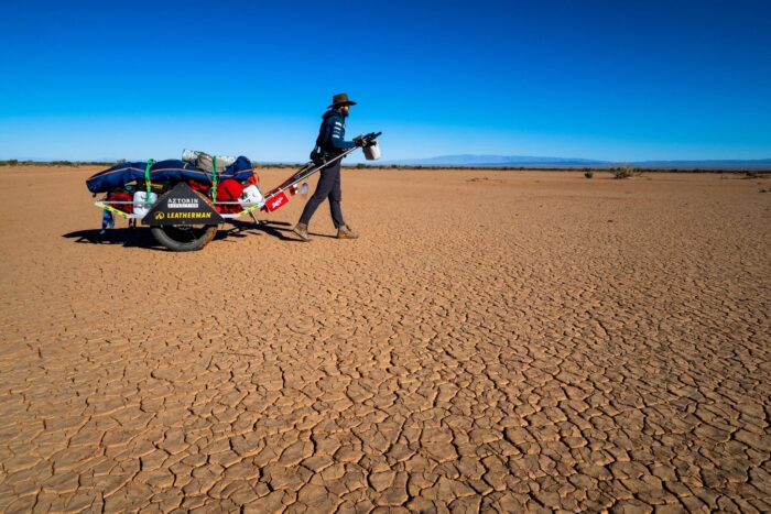
Desert of My Dreams: Vedangi Kulkarni recently set her eyes on a solo unsupported cycle around the globe, aiming to set a women's speed record. Because of the visa difficulties associated with an Indian passport, she followed a non-traditional route, and this brought unexpected logistical challenges. When it became clear the record was out of reach, she shifted her focus. In April 2025, after covering 29,030km over 270 days, Kulkarni completed her second global cycle while still only in her mid-twenties.
Mapping the myth: In search of Homer’s enchanted islands:Although Greek mythology is fictional, some classicists have explored connections between myth and reality. British-American classicist Emily Wilson suggests that "there is some correspondence between the world of Homer and the real world, although the relationship is partial and inexact." This piece traces the islands that may have inspired the travels of Homer’s epic hero, Odysseus.
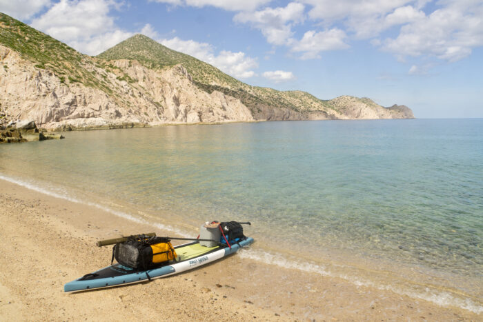
Baja Peninsula in Mexico. Photo: Sean Jansen
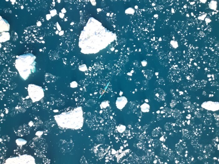
Paddling with porpoise
It Began With a Paddle: At his lowest point, the stark beauty of Mexico’s Baja Peninsula offered Sean Jansen a lifeline, a glimpse into a different kind of life. One rooted in giving back to the environment he had once taken for granted. It was a chance to start over, dedicating his energy to protecting Mexico’s most endangered species. And it all began with a paddle.
Sixty Years Later: Finding -- and Climbing -- the Troll Wall: Sixty years after completing the first ascent of Troll Wall, Europe's highest and steepest cliff, British climber Tony Howard reflects on his experience and shares a short account of how the climb unfolded.
Revelry Collection: It seems there's a fresh digital counterculture in the outdoor world, with new print magazines and zines appearing at a steady rate. This offering from a young American high schooler only publishes original film images. It looks polished and has hooked in well-known outdoor photographers such as Alex Strohl and Taylor Burke.
In 1974, Ed February stands atop one of the Krakadouw peaks in South Africa’s Cederberg Mountains. With Dave Cheesmond, he had just completed the first climb of a new route they named 'Orang-Outang.' Photo: Ed February
Playing His Own Game: Despite climbing during South Africa’s apartheid era, Ed February achieved success both in the mountains and in academia. In this story from Alpinist, Brandon Blackburn explores how February defied racist barriers to follow his passions, always forging his own path.
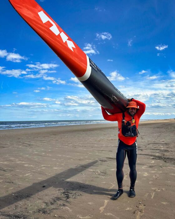
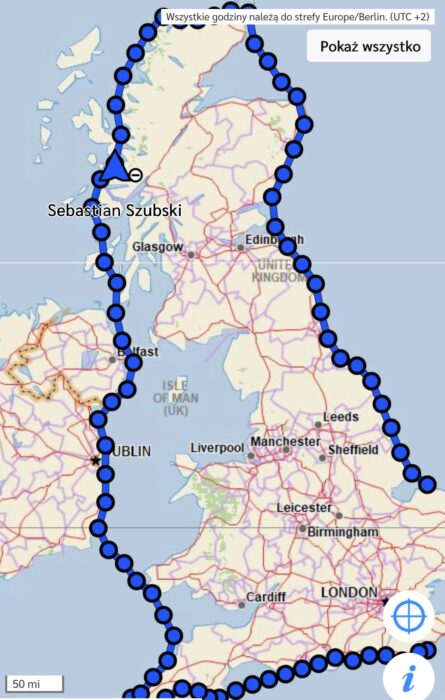
On July 18, Polish paddlesports athlete Sebastian Szubski completed a solo kayak circumnavigation of Great Britain. He covered the 3,000km route in 37 days, finishing three days faster than Dougal Glashier, the previous record holder from 2023.
Szubski began his journey in Western Scotland on June 12 and initially faced challenging waves, fatigue, and changeable weather conditions that are typical of the British coastline. His route led him around Scotland’s rugged coast, down the coasts of England and Wales, across the Bristol Channel, through the Irish Sea, past both Ireland and Northern Ireland, and ultimately back to Scotland.
For much of the route, Szubski was neck-and-neck with Glashier's time, paddling an average of 80km to sustain his target of 40 days.
Key moments
“Scotland welcomed me as if it were paradise on Earth. Beautiful, with seals, views, and no waves because I was hidden among the islands. I decided to start higher than I had planned. It turned out I'd chosen the most beautiful spot in all of Great Britain,” Szubski told Red Bull Poland.
However, on day two, this short-lived idyllic start was replaced by rudder issues, a leak, and rough seas that left him unable to control his boat properly. He narrowly avoided crashing into the cliffs at the famous sea stack of the Old Man of Stoer.
Photo: Sebastian Szubski
From the seventh day, Szubski’s journey settled into its routine of paddling, eating, and sleeping. He often spent up to 16 hours a day in his kayak. The timing of his efforts was frequently dictated by tidal currents, sometimes requiring pre-dawn starts in gnarly weather. These early rises became essential for staying on schedule.
By the eighteenth day, he reached the halfway point. Navigating past Dover under the cover of night helped him avoid the world's busiest shipping traffic, though technical issues left him without lights or radio communication.
A support team followed Szubski the entire way. On land, recovery was the top priority, although each landing also required recording footage for Guinness record documentation, changing into dry clothes, and eating high-calorie meals. He received massages from his support team and slept, at least at times, in a rooftop tent.
Olympic pedigree
When Szubski announced his intention to circumnavigate Britain by Kayak, some in the British paddling community were skeptical. He had reportedly never kayaked at sea, let alone the rugged British coast, which can be technically challenging and dangerous.
In preparation, in July 2024, Szubski and Sebastian Cuattrin paddled a 200km section of the River Thames in England in just under 22 hours. A few months later, that fall, the Pole visited and trained with Mike Lambert, a former British canoe sprinter who completed a 58-day kayak circumnavigation earlier in the year.
Photo: Sebastian Szubski
Although born in Poland, Szubski represented Brazil in the 2004 Summer Olympics in the sprint canoe event and the 500m doubles kayak. He also holds the record for the farthest distance by canoe or kayak on flat water in 24 hours -- an impressive 252km.
Fastest known time
Szubski has claimed his circumnavigation as the fastest kayak journey around Great Britain, and a number of news sources have suggested he has broken a Guinness World Record. How Guinness will ratify this record is unclear, as they do not currently appear to have published a comparable record on their website. Also, for some in the adventure community, they are not a credible record-keeping organization.
Szubski GPS tracks. Image: Sebastian Szubski
Dougal Glashier previously held the fastest known time, although his route was reportedly 3,120km -- slightly longer than the 3,000km initially reported by Szubski. Both Glashier and Szubski had support crews, but details remain unclear regarding how much they relied on them, whether they camped wild or stayed in accommodations, and how similar their routes were.
In 2012, Joe Leach, the previous record holder, completed the journey in 67 days, a benchmark Glashier surpassed by an impressive 27 days.
]]>https://explorersweb.com/pole-claims-fastest-kayak-circumnavigation-of-britain/feed/0Trapped Caver Saved After Rescuers Use Explosives
https://explorersweb.com/trapped-caver-saved-after-rescuers-use-explosives/
https://explorersweb.com/trapped-caver-saved-after-rescuers-use-explosives/#respondThu, 24 Jul 2025 04:30:59 +0000https://explorersweb.com/?p=106867
A 63-year-old speleologist has been rescued from the Abisso Paperino cave system in northern Italy after suffering a head injury approximately 40m below the surface. The incident occurred on Sunday when falling rocks struck the man while he was in the cave with team members.
Specialist emergency responders, including a medical team, reached the injured caver the same day. He received treatment inside a specially installed heated tent within the cave. While the severity of the head injury remains unclear, the man was unable to exit the cave system without assistance.
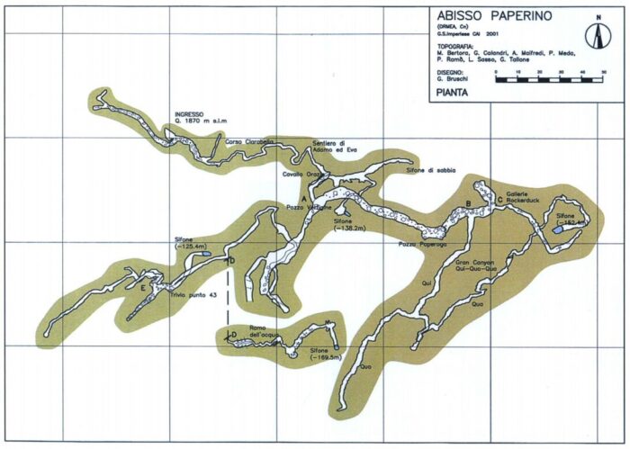
Inside Italy’s Abisso Paperino cave system
The Abisso Paperino cave system in northern Italy reaches depths of up to 154m and is approximately 1,700m long. Accessible via a dirt road, the cave begins with a 28m vertical shaft that opens into a complex labyrinth of underground galleries, shafts, and winding sections. Notable features within the system include the Cavallo Orazio chamber, the central Pozzo Vertigine shaft, and a series of fossil galleries and water-filled siphons, making it an interesting site for speleologists and cavers.
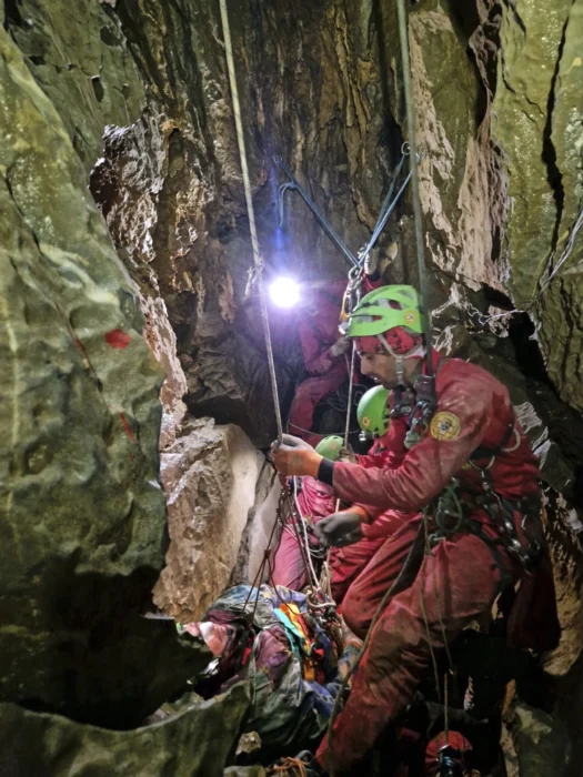
The Abisso Paperino Cave System in Northern Italy. The exact location of the injured caver within the complex underground network remains undisclosed. Photo: Catastogrotte-Piemonte
To extract the injured man from the Abisso Paperino cave system, rescue teams used controlled explosive charges to widen three critical passages. This allowed members of the Italian National Alpine and Speleological Rescue Corps to safely transport the man back to the surface through the narrow, challenging terrain.
Rescue teams attend to the injured caver inside the Abisso Paperino cave system. Photo: National Alpine and Speleological Rescue Corps
The injured speleologist’s ascent to the surface on Monday involved climbing through two vertical shafts, each approximately 15m high. Rescuers also had to navigate a complex maze of tight, winding cave passages to complete the operation successfully.
]]>https://explorersweb.com/trapped-caver-saved-after-rescuers-use-explosives/feed/0Three Ski Lines and the Cassin Ridge, All in One Denali Season
https://explorersweb.com/three-ski-lines-and-the-cassin-ridge-all-in-one-denali-season/
https://explorersweb.com/three-ski-lines-and-the-cassin-ridge-all-in-one-denali-season/#respondWed, 23 Jul 2025 16:00:35 +0000https://explorersweb.com/?p=106757
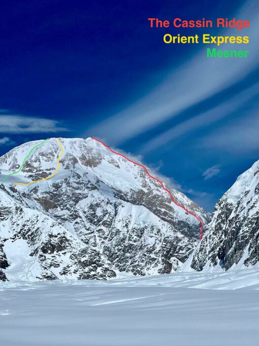
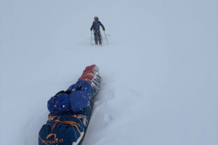
On May 28, Max Kilcoyne stood alone above 6,000m. Below him, clouds swirled over the Kahiltna Glacier. Above him, only the upper ridgeline of McKinley and the summit of Mount Foraker pierced the darkening skies. His hands were cold, his phone had just died, and he was alone. But he clicked into his skis and dropped in anyway.
Kilcoyne had just graduated from the University of Colorado Boulder, and now eight days later, he was nearly 5,000km north on the flanks of North America’s highest peak, solo skiing the Orient Express, a 1,000m couloir that slices straight off Mt. McKinley's upper slopes at angles that touch 50°.
"I don’t have many pictures from this day as I was by myself and my phone died, but I’ll have the memories of that ski forever," said the young American ski mountaineer.
What followed was a series of ski mountaineering linkups. Over 24 days on the mountain, Kilcoyne soloed and skied the Orient Express, climbed and skied down the Messner Couloir, and then climbed the legendary Cassin Ridge, skiing back down Rescue Gully.
In between, there were other forays high on the mountain. He skied nearly every day of the trip, 21 out of 24, and completed the Cassin just a week after finishing the Messner.
A grind to 14,000 Camp
Kilcoyne arrived in Talkeetna on May 18 with American mountain athletes Anna DeMonte and Jack Kuenzle. The goal was for Kilcoyne to support DeMonte and Kuenzle on a fastest known time (FKT) attempt on McKinley, and then, if all went well, climb the Cassin Ridge. After weather delays grounded the many climbers waiting to fly out to the Kahiltna Glacier, Kilcoyne’s team finally flew on May 21 when the clouds broke.
Anna DeMonte, with Max Kilcoyne (left) and Jack Kuenzle in the background. Photo: Anna DeMonte
"The rangers really enjoyed the extra-large bottle of tequila we had given to them the day before," Kilcoyne joked when asked what may have earned them a seat on the flight out of town.
The next three days were spent dragging heavy sleds up the Kahiltna Glacier to 14,000 Camp, which sits at 4,300m on a plateau below the upper slopes of the mountain. "Any amount of incline with that much weight just feels like death," said Kilcoyne.
The three-strong team arrived at 14,000 Camp on May 23. That same week, DeMonte and Kuenzle made an early push toward Denali Pass at 5,500m to get some mileage in. Kilcoyne, feeling tired, stayed behind and dug out the cook tent.
Orient Express Couloir (May 28)
On a day when DeMonte and Kuenzle stayed in their tents, Kilcoyne headed up Orient Express Couloir solo. With no fixed lines, no partner, and no certainty about the conditions above, he pushed through deep snow and low visibility, booting into the white void above. By 5,400m, he was out of food. The wind picked up, and he walked backwards up the hill to protect his face.
Two of the three lines Kilcoyne skied this season. Photo: Max Kilcoyne
Still, he kept climbing. At 6,140m -- just 45m shy of the summit -- he decided to stop. The wind chill temperature had dropped, and he knew he needed working fingers to take off his crampons and clip into his skis. He also planned to summit multiple times later in the season.
What followed was a descent in perfect conditions, skiing steep powder, without another soul on the route. "One of the most euphoric skis of my life," he said. "I got back to camp at 8 pm and couldn’t stop shivering all night but was stoked out of my mind."
Messner Couloir (June 6)
DeMonte and Kuenzle’s speed record attempt ended on May 29 when DeMonte was injured in a fall while skiing at 4,900m. A week later, Kilcoyne joined Wesley Perkins and Emmett Itoi to attempt the Messner Couloir, a direct line that drops 1,500m from just below McKinley’s summit. No one had skied it yet that season.
Max Kilcoyne (left) with his new companions. Photo: Max Kilcoyne
The trio climbed the couloir from 14,000 Camp to 5,900m, where Itoi decided to wait, leaving Kilcoyne and Perkins to summit in strong winds. On the way back, they rejoined Itoi and skied back down the Couloir. The snow was stable, and visibility was excellent. "All of 14,000 Camp was watching us as we opened it for the season," Kilcoyne said.
Kilcoyne, Perkins, and Itoi breaking trail up the Messner Couloir. Photo: Max Kilcoyne
"We picked the most notable features from a photo, and then I got to make the first turns down. It felt committing, not really knowing where you are on such a big face, but it couldn’t have gone better."
Cassin Ridge and Rescue Gully (June 13)
Kilcoyne had long set his sights on the Cassin Ridge. "The Cassin meant the most to me by far. That has been a priority for me for the last two years, and it was amazing to see it come to fruition."
He and Perkins teamed up again and left 14,000 Camp on June 10, skied the Seattle Ramp to access the base of the route, and climbed light and fast. Night one was spent on a narrow ice ledge. Night two was spent tied to an ice screw on a ledge barely wide enough for one person. One of Kilcoyne’s food bags for the next day tumbled off into the void.
"The hardest thing about the linkup of the Cassin and Rescue Gully was probably just how remote you are and how hard it is to manage your gear in those temperatures. I brought three pairs of gloves, and by the end of day one, all of them were completely soaked and frozen solid. Your ski boots get wet and then freeze; pretty much everything gets wet at some point and then freezes solid. Climbing through some of the cruxes with skis on our backs was also quite difficult," Kilcoyne noted.
Kilcoyne leading the crux WI4 pitch on the Japanese Couloir on the Cassin. Photo: Max Kilcoyne
The route tested their mixed climbing skills, with M4/M5 terrain in places, simul-climbing with skis on their backs, and trail breaking in deep snow. On June 13 in the evening, they topped out on the Kahiltna Horn and skied around 1,800m back to 14,000 Camp via Rescue Gully.
"We topped out Kahiltna Horn at 8:33 pm, put on all our layers, put skis on, and ripped down as fast as possible. Neither of us had any interest in going the last 150 feet on the ridge to the true summit."
A skier had died on Rescue Gully in an avalanche a few days beforehand, and the pair were understandably apprehensive about skiing the gully when fatigued. Regardless, they managed the descent without any issues.
A successful first trip
The trip was not without hardship. DeMonte suffered a bad leg injury and had to be evacuated by helicopter. Kuenzle left to assist her. That left Kilcoyne alone, adapting to new partners and plans. But the mountains had more to offer, and he kept skiing.
"I can’t speak to how rare it is to do what I did this season on Denali as I am new to the Alaska scene," he says, before adding he saw "no one else ticking multiple ski lines on Denali this year."
For Kilcoyne, this first trip to McKinley brought together the many alpine tools he has built over time. From trail running and ski mountaineering as a kid in Boulder, to mixed climbing all winter to prepare for McKinley’s alpine terrain, it all came together in one highly productive season.
]]>https://explorersweb.com/three-ski-lines-and-the-cassin-ridge-all-in-one-denali-season/feed/0From the Yukon to the Arctic: 1,700km by Bike and Canoe
https://explorersweb.com/from-the-yukon-to-the-arctic-1700km-by-bike-and-canoe/
https://explorersweb.com/from-the-yukon-to-the-arctic-1700km-by-bike-and-canoe/#respondTue, 22 Jul 2025 05:15:38 +0000https://explorersweb.com/?p=106776
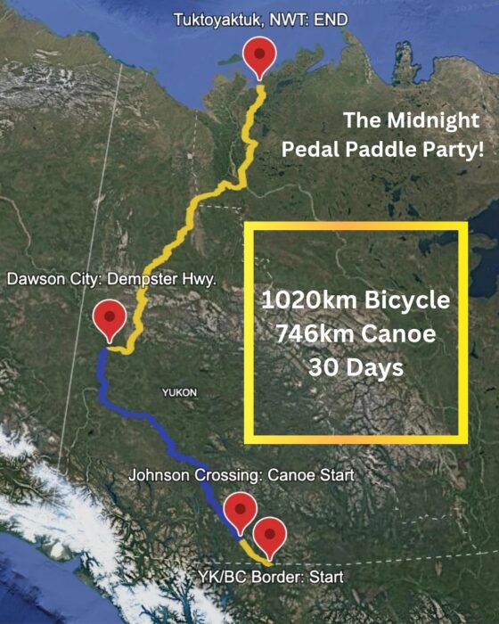
Last month, Canadian adventurers Dave Greene and Gaia Aish completed a 1,725km bike and canoe journey from the British Columbia border to the shores of the Arctic Ocean over 30 days.
The pair started on May 22 from the border of British Columbia and the vast Yukon Territory. To begin, they pedalled around 100km to a small settlement by the Yukon River, where they picked up their pre-stashed Canoes. "It was a good little break into the trip. A little gear shake down, if you will," Greene explained.
From here, Greene and Aish set out on a 746km canoe leg along the river, where they faced no major rapids or portages, but low water levels and snow melt made the journey challenging. As a result, they spent long hours in the boat, with paddling sessions stretching to 12 hours a day.
"We managed to cover significant distance by doing that; we were paddling 60, 70, sometimes 80km in a day," Greene reflected.
Yukon delights
Despite the long days, Greene enjoyed the Yukon River: "It was an incredible part of the trip, maybe the most memorable part for us."
This may have partly been because the two Canadians were treated to a host of wildlife sightings, including both moose and bears with babies, lynx, sheep, wolves, and even a wolverine.
Bikes stashed in the canoe on the Yukon River. Photo: Dave Greene
Greene and Aish carried their bikes in the canoe down the Yukon. When they eventually reached the end of the canoe leg in the historic gold rush town of Dawson City, they left their rented canoes with a company that returned them to the south.
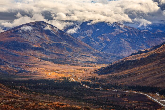
At Dawson, the duo got back on their bikes. On June 12, they headed out onto the Dempster Highway, Canada’s only road north to the Arctic Ocean. The cycle north took twelve days, and the 940km they covered was hard earned.
Greene and Aish pedalled through a summer heatwave, prompting night rides to avoid the intense heat. The gravel road and dry climate made finding drinkable water difficult, as well as turning the ride into a dusty affair.
"The Dempster is a gravel road. So, being as hot as it was, it was also extremely dusty. We had dirt kicked into our faces, in our ears at all times," Greene said.
The Midnight Pedal Paddle Party
A benefit of riding this far north is the extended daylight hours, hence Greene dreaming up the expedition moniker, the "Midnight Pedal Paddle Party."
"We were north of the Arctic Circle for the majority of this bicycle ride, which means that the sun was not setting. So we had 24 hours of daylight, which, after a certain amount of time, one just gets used to. You get tired enough that you can just lie down and sleep, but it also allowed us to ride our bikes whenever we wanted," Greene explained.
Crossing the Arctic Circle. Photo: Dave Greene
To ease some of the weight burden while cycling, Greene and Aish turned to the Dawson City Visitors Center, which allows cyclists to leave food boxes for pickup by drivers heading to Eagle Plains Hotel, a pit-stop 500km into their route. Additionally, they had a friend in the Northwest Territories, so they met with them to collect another box of food. At most, they had to carry seven days of food at a time.
To the ocean
The final 150km from Inuvik to Tuktoyaktuk were the most demanding of the expedition, thanks to the freshly gravelled road.
"It was four to six inches of fresh gravel and we had to push our bikes up all of the hills, because it was simply unrideable," Greene recalls.
Camp for the night. Photo: Dave Greene
Their spirits picked up when they reached the Arctic Ocean and the community of Tuktoyaktuk on June 23, marking the end of their trip.
"Getting to the Arctic Ocean was quite the thrill. The community of Tuktoyaktuk is an Inuit community in Canada, and we happened to arrive the same day they were having their indigenous day, a territorial holiday," Greene said.
Naturally, the weary -- and no doubt sweat-encrusted -- cyclists celebrated by jumping into the Arctic Ocean.
]]>https://explorersweb.com/from-the-yukon-to-the-arctic-1700km-by-bike-and-canoe/feed/0Adventure Links of the Week
https://explorersweb.com/adventure-links-of-the-week-105/
https://explorersweb.com/adventure-links-of-the-week-105/#respondSun, 20 Jul 2025 16:00:47 +0000https://explorersweb.com/?p=106583
When we’re not outdoors, we get our adventure fix by exploring social media and the web. Here are some of the best adventure links we’ve discovered this week.
Soul Mountaineer -- In Conversation with Tamara Lunger: Italian alpinist Tamara Lunger started her journey in the mountains through ski mountaineering, eventually discovering her true calling in high-altitude climbing. She became the youngest woman to summit Lhotse and later reached the top of K2 without supplemental oxygen.
However, her path took a painful turn following the deaths of close climbing partners. Struggling with grief and searching for a new direction, she turned her focus to regeneration, realising she had never allowed herself the time or space to recover.
Does Hiking to Mount Everest Base Camp Make You Want to Reach the Summit?: Ben Ayers, Outside’s basecamp correspondent, explores whether trekking to Mount Everest Base Camp motivates you to attempt the summit. Drawing on his experience living in Nepal for over two decades, he reflects on how common it is for guided Base Camp hikers to feel inspired to climb -- and how guiding outfits leverage this connection by operating both trekking services and summit expeditions.
New Trails in the Middle East
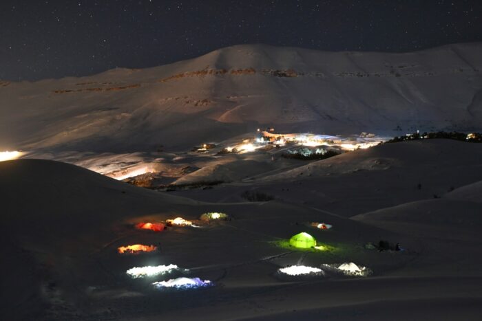
Night-time winter camping in Lebanon’s mountains. Photo: Gilbert Moukheiber
The Hiking Trails Reshaping Lebanese Tourism: Lebanon is developing a 400km network of hiking trails through the Anti-Lebanon and Mount Lebanon ranges to boost rural tourism and support local communities. Led by guide Gilbert Moukheiber, the Boukaat Loubnan Trails project connects around 50 villages, offering hikers cultural experiences, homestays, and local food. Despite challenges from regional instability, the trails aim to revive economies and promote sustainable tourism.
This Hiker Exploded a Can of Fuel Through the Ceiling, Don’t Make the Same Mistake: Backpacker reports that using fuel transfer devices like FlipFuel to consolidate partially used isobutane canisters can save space. But mishandling, especially overheating or overfilling, can cause catastrophic explosions. Users share stories of canisters bursting after they have heated them in boiling water or on stoves, causing severe property damage and injury.
A Departing Legend
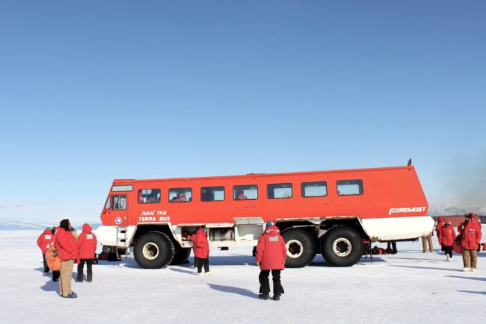
For three decades, Ivan the Terra Bus reliably shuttled passengers between Antarctica’s airfields and research stations. The 2024–25 summer season marked its final journey across the ice. Photo: Eli Duke/CC BY-SA 2.0
The Bus, the Myth, the Legend:This podcast episode pays tribute to "Ivan," the iconic Terra Bus that has ferried researchers and workers between McMurdo Station’s airfield and base for over three decades in Antarctica. Hosts Dylan Thuras and Allegra Rosenberg explore its origins, as well as its distinctive physical presence: massive tires, a wood-paneled interior loaded with stickers, and bright orange-red paint. Drivers recount its quirks, such as the lengthy 30–60 minute engine warm-up, fogged windows, and leisurely 15–20mph pace.
As McMurdo modernised, Ivan symbolised a nostalgic link to Antarctica’s past, complete with songs and fond memories. Facing retirement because of parts shortages and cost, the bus was saved from the scrap heap by a grassroots campaign that relocated it to Christchurch for preservation.
Unpacking a Controversy
Photo: Guardian Design/Jim Wileman
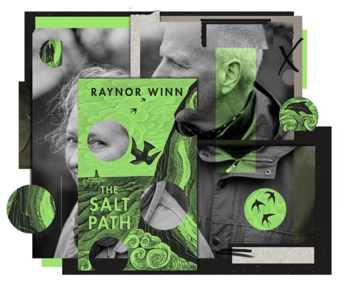
Inside the Salt Path controversy: This Guardian article examines the controversy surrounding Raynor Winn’s bestselling memoir The Salt Path, which chronicles a 1,000km walk along England’s coast. While recent investigative journalism questions elements of Winn’s story, this piece broadens its focus to explore how memoirs, especially those centered on transformative journeys like long-distance walking, often blur fact and narrative. It highlights the genre’s long history of embellishment and the lack of rigorous fact-checking, raising questions about truth, trust, and the responsibility of both writers and publishers.
A new film, Everest Revisited: 1924–2024, invites viewers to look beyond the headlines to consider what Everest has come to mean, both in the past and the present. The film, which was publicly released earlier this week, won the Jury Special Mention Award at the 2024 Kraków Mountain Festival and was runner-up for the Audience Choice Award at the 2024 London Mountain Film Festival.
The 41-minute documentary, produced in association with the Alpine Club and the Mount Everest Foundation, weaves together archival footage with analysis and reflection from some of the UK's leading Everest enthusiasts.
Narrated compellingly by mountaineer Matt Sharman and anchored by the personal connection of Sandy Irvine’s great-niece, Julie Summers, Everest Revisited is less a dramatic retelling of Everest history and more a reflective journey through the mountain’s cultural and spiritual legacy.
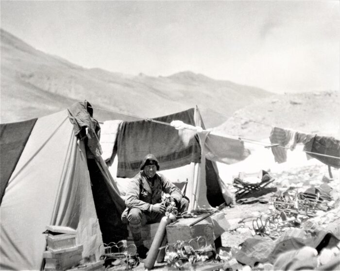
Sandy Irvine working on oxygen equipment in 1924. Photo: Bentley Beetham Collection
At the heart of the documentary are the expeditions of the 1920s, with particular focus on the ill-fated 1924 attempt by George Mallory and Sandy Irvine. With contributions from mountaineers and historians such as Rebecca Stephens, Leo Houlding, Stephen Venables, Chris Bonington, Krish Thapa, and Melanie Windridge, the film explores how these early attempts were shaped as much by imperial ambition and scientific curiosity as they were by the challenge of climbing itself.
A critical examination
Rather than idealise the past, the film examines it critically. It acknowledges the hierarchy embedded in British imperial attitudes, particularly toward the Sherpas and high-altitude porters who made these expeditions possible. The film highlights the essential, and often overlooked, contributions of figures like Karma Paul and Gyalzen Kazi, who bridged very different cultures. Porters like Paul and Kazi quite literally carried early Everest expeditions forward.
Everest Revisited also looks forward. Blending stories from climbers like former Gurkha Krish Thapa, who helped double-amputee Hari Budha Magar summit Everest in 2023, the film draws links between notions of historic heroism and modern questions of easy access and motivations. Despite the growing queues on Everest’s slopes and its increasingly commercial reputation, writer and climber Ed Douglas suggests that modern climbers may not be too dissimilar to those of the past.
"We tend to think that Everest is kind of somehow more complicated, more cynical, and less illustrious than it used to be. I think we need to look back at these expeditions with a more honest eye, because these are not simple, heroic people. These are people with the same motivations and the same, you know, concerns and the same complexities we have. They weren't always honourable. They weren't always perfect," Douglas reflected.
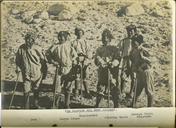
The porters who went to over 27,000ft (8,200m) in June 1924. They established and supplied the high-altitude camps that George Mallory and Sandy Irvine would use to make their attempt on the summit of Everest. They are dressed in wind-proof cotton smocks, woollen helmets, gloves, goggles, boots, and puttees issued to them by the expedition. The expeditions and much of the climbing were only possible due to the huge contribution of Indigenous workers. Photo: The Alpine Club
Emphasizing the unknown
Visually, the film integrates modern and archival footage of Himalayan landscapes with impactful interviews and primary artifacts, such as photos and equipment from early expeditions.
Rather than offering a final verdict on Mallory and Irvine’s fate, the film leaves room for mystery. It emphasizes the unknown. As climber Leo Houlding poignantly tells Irvine's great-niece Julie Summers, "I hope we never find your great uncle and I hope we don't find the camera. I hope that the mystery endures for another century."
Julie Summers and Leo Houlding discuss Mallory and Irvine’s final attempt on the summit. Photo: The Alpine Club
Everest Revisited is a film about more than just mountaineering. It’s about memory and the shifting values we project onto the world's highest mountain. The documentary will intrigue climbers, historians, and anyone drawn in by the enduring allure of the world's highest mountain.
]]>https://explorersweb.com/weekend-warmup-everest-revisited-1924-2024/feed/0Circumnavigating the Globe: An Artist’s Journey by Wind, Foot, and Ski
https://explorersweb.com/circumnavigating-the-globe-an-artists-journey-by-wind-foot-and-ski/
https://explorersweb.com/circumnavigating-the-globe-an-artists-journey-by-wind-foot-and-ski/#respondThu, 17 Jul 2025 10:00:56 +0000https://explorersweb.com/?p=106565
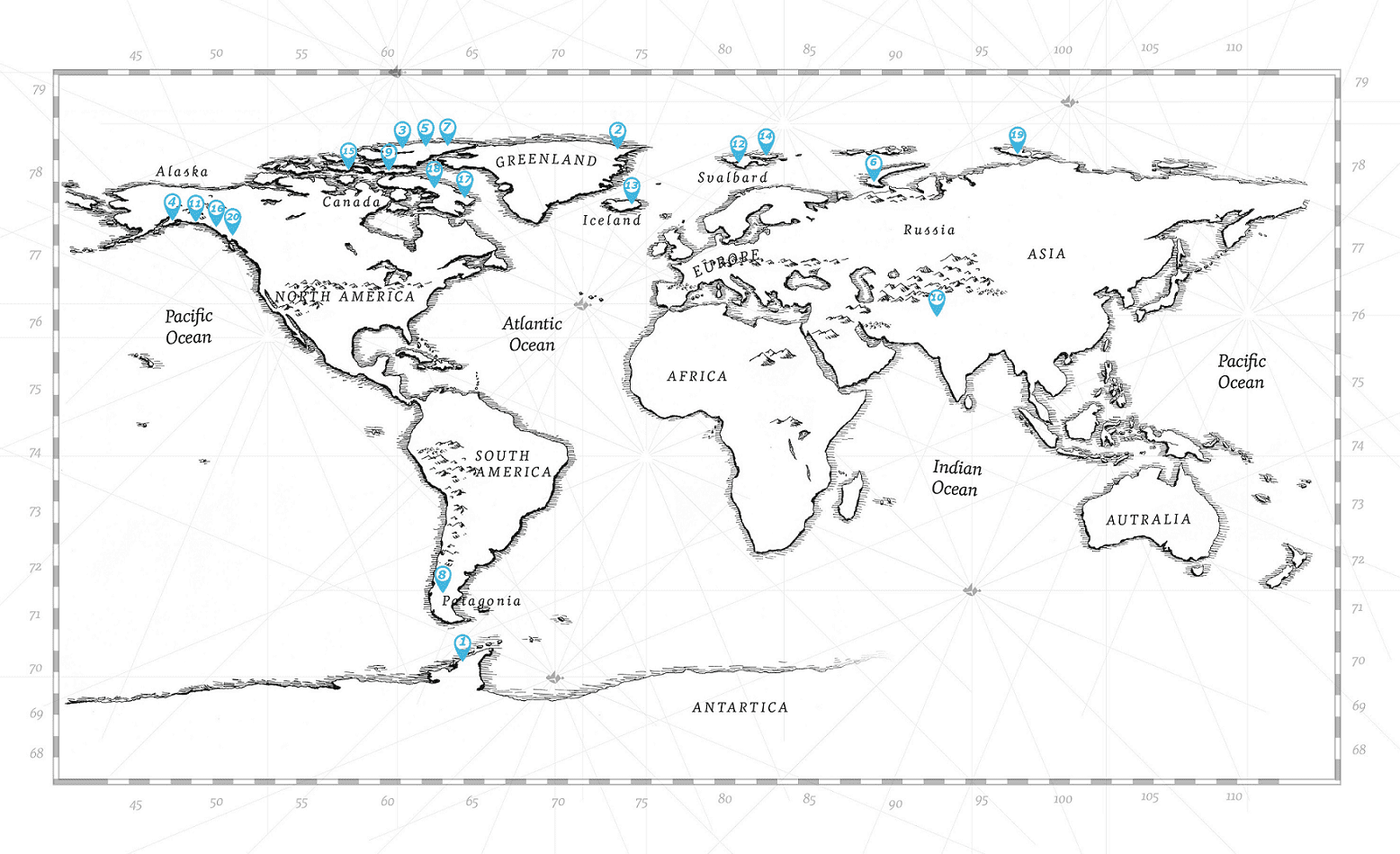
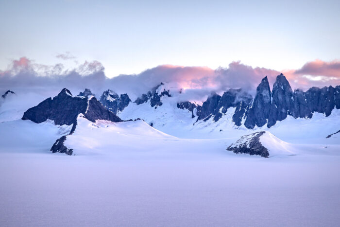
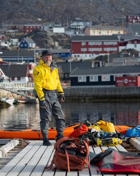
German artist Katharina Kneip is 900 days into an ambitious project to circumnavigate the top of the globe. Kneip started in January 2023 from Münster, Germany, and aims to hike, ski, and sail around the planet back to her starting point without motorized support.
Kneip has been on the road for over two years as part of a project she calls Round:Motion, which is based on the ethos of sustainability, cultural and artistic exchange, and a mindful pace. She aims to avoid competitive metrics often associated with long-distance adventure travel, like distance or records.
Traveling alone or occasionally accompanied by friends, the German artist turned adventurer travels by foot or skis on land, and by sailboat or kayak on water. Kneip relies on a network of sailors and helpful communities encountered along the way.
4,300km from Germany to Norway
Usually, Kneipp provides limited information on distances and the finer details of her journey, but we twisted her arm to reveal more.
The first phase of this multi-year odyssey began on Jan. 23, 2023, with a solo 4,300km hike and kayak leg from Münster to Kirkenes, near Norway’s northern tip. Most of this section was hiking, following well-known trails such as Norway’s Olavsleden and Sweden’s Kungsleden, but there were also short kayak segments between Denmark and Sweden. Kneipp arrived in Kirkenes in early September.
Undaunted by the large backpack. Photo: Katharina Kneip
Along the way, Kneip weaved in artistic collaborations, such as with Norwegian dancer Signe Alexandra Domogalla. The pair explored themes of movement and nature through workshops and exhibitions in Oslo.
Logistically, Kneip keeps things simple: "I don’t send food packages or anything like that ahead, and I don’t hitchhike or take public transport to reach supermarkets. But of course, I’m not carrying food for several months. I plan my route so that I reach a shop from time to time. The most food I carried was for 20 days while hiking, and 25 days in the Pulka [sled] while crossing Iceland."
Winter sledding. Photo: Katharina Kneip
From Kirkenes, where she overwintered, Kneip resumed her journey in March 2024, with a long 900km leg south to Tromsø. She managed 750km on skis, with 150km on foot when snow conditions required detours. For some of this leg, Kneip was joined by two friends.
Crossing the Arctic
Kneip then secured passage by sailboat to Longyearbyen, Svalbard, working as both a guide and crew member during her stay. By late summer 2024, she had sailed to East Greenland, where she continued to Isafjordur, on the far west coast of Iceland. From there, she hiked a 500km route in September 2024, from Isafjordur to a farm near Akureyri, where she spent the next winter.
Careful navigation of closely packed ice has been required at times. Photo: Katharina Kneip
If that wasn't enough, in March of this year, Kneip and companion, Dirk Langer, completed a 350km winter ski crossing of Iceland from near Akureyri in the north to Eyrarbakki in the southwest. Kneip then completed a solo 450km trek from Akureyri to Reykjavik in May and June.
All smiles on the water. Photo: Katharina Kneip
Kneip recently arrived in Labrador after sailing from Iceland to Greenland and then on to Canada. From here, she hopes to continue her journey, pending approval from Canadian authorities, by hiking around 7,000km and skiing another 3,000km before reaching Alaska. From there, she plans to sail across the Bering Strait into Russia. With much of the route still ahead and the unknowns of future travel in Russia, it will be several more years before she sees her finish line back in Germany.
]]>https://explorersweb.com/circumnavigating-the-globe-an-artists-journey-by-wind-foot-and-ski/feed/0The Hudson Bay Girls: Canoeing 1,900km Through the Heart of Canada
https://explorersweb.com/the-hudson-bay-girls-kayaking-1900km-through-the-heart-of-canada/
https://explorersweb.com/the-hudson-bay-girls-kayaking-1900km-through-the-heart-of-canada/#respondTue, 15 Jul 2025 07:00:10 +0000https://explorersweb.com/?p=106555
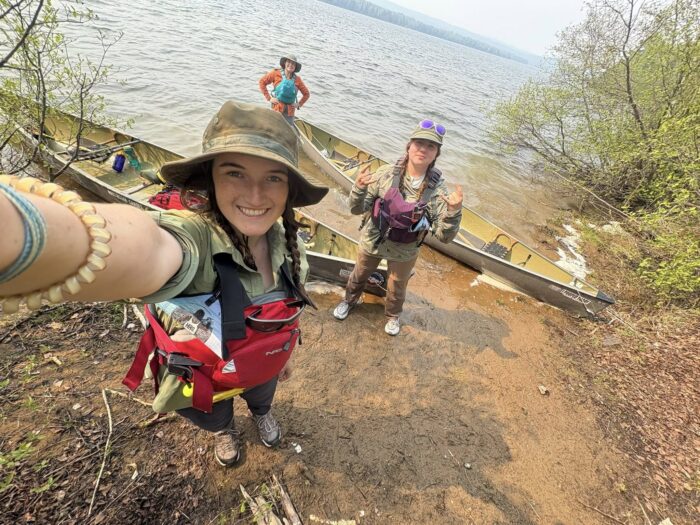
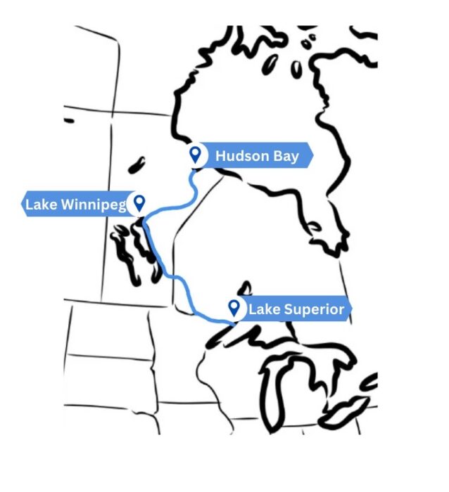
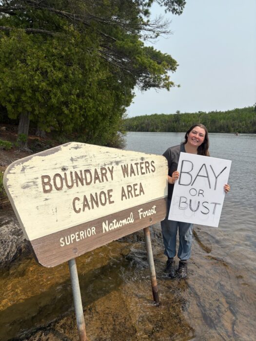
An all-female team known as the "Hudson Bay Girls" is more than a month into a self-supported 1,900km canoeing expedition from Grand Portage on Lake Superior to York Factory on Hudson Bay.
Their route follows traditional waterways first traveled by the Anishinaabe people, and later used by French fur traders in the 18th and 19th centuries to connect remote trading posts across the Canadian wilderness.
The journey, expected to take 85 days, began at the end of May with a challenging 13km portage, known locally as "Grand Portage." From there, the team paddled 400km through the pristine Boundary Waters wilderness area, which is threatened by proposed mining projects.
Paddling in the Boundary Waters. Photo: Hudson Bay Girls
Building on experience
The team has plenty of paddling and wilderness experience, having collectively paddled over 6,400km. The foursome of Olivia Bledsoe, Emma Brackett, Abby Cichocki, and Helena Karlstrom has varied backgrounds, including roles as wilderness canoe guides, wilderness medical technicians, and trail maintenance foremen in the Boundary Waters and Quetico Provincial Park.
Olivia Bedsoe (front), Helena Karlstrom (middle), and Abby Cichoki (back). Photo: Hudson Bay Girls
The Route Ahead
Recently, the expedition passed through Voyageurs National Park. They stopped to resupply at the city of International Falls, Minnesota, which straddles the U.S and Canada border. The next leg of their journey involves paddling north across Lake of the Woods, a vast body of water notable for its thousands of islands and indigenous heritage.
A rough illustration of the route. Image: Hudson Bay Girls
Following Lake of the Woods, the team will navigate the 240km Winnipeg River. From there, they'll paddle along the eastern shores of Lake Winnipeg for three to four weeks, likely contending with shallow waters and large swells.
The Hudson Bay Girls are determined to complete their journey. Photo: Hudson Bay Girls
The expedition's final stretch is the 480km Hayes River, a Canadian Heritage River historically used by the Hudson Bay Company as a key trading route. The river transitions dramatically from boreal forest to sub-arctic tundra and is home to several Cree communities.
All being well, the Hudson Bay Girls' journey will culminate at York Factory -- a historically significant trading post pivotal to Canada's fur trade era -- in Hudson Bay.
York Factory, now a Canadian National Historic Site. Photo: Wikipedia
Last month, Icelanders Hoddi Tryggvason and Halldor Meyer completed a 4,200km circular snowkiting journey on Greenland’s ice sheet. The 50-day expedition began and finished near Tasiilaq on Greenland’s southeastern coast.
Beginning on May 10, the pair was initially accompanied by Danish adventurer Bjorn Lindhardt Wils as they traveled clockwise, passing the historic Cold War radar stations DYE 3 and DYE 2 on their way to Greenland’s west coast.
Early struggles and injury
In the early stages of the all-Scandinavian team’s journey, they contended with poor visibility and heavy snowfall. But the situation worsened when Wils injured himself while kiting, an all-too-common risk in the sport due to the high speeds and unpredictable winds. "Something went terribly wrong with his kite when he was launching it in really strong winds," said Tryggvason.
Wils was evacuated by helicopter due to his injuries. Photo: Hoddi Tryggvason
“He was catapulted several meters up in the air, came crashing down, and hurt himself quite badly,” Tryggvason continued. “He still tried to keep on kiting until it was just pointless.”
All three had previous snowkiting experience on Greenland, having kited 1,800km together from DYE 2 to Qaanaaq in 2022. Tryggvason has also kited from near the South Pole to Hercules Inlet, and Wils kited 2,400km from Narsaq to Qaanaaq in 2016.
The abandoned DYE 2 radar station. Photo: Hoddi Tryggvason
Previous kiting expeditions
Most kiting teams in Greenland travel a linear route from north to south, from Kangerlussuaq to Qaanaaq.“We wanted to do something a bit more challenging…something that not many people do,” said Tryggvason.
Tryggvason's GPS track. Map: Hoddi Tryggvason
Few teams choose longer journeys. However, 2014 saw multiple teams undertake circular snowkiting expeditions around the interior of Greenland. The longest was the "Wings Over Greenland II" expedition by Michael Charavin and Cornelius Strohm. They covered 5,067km in 58 days, completing a loop around the ice cap from Narsaq in the far south.
At the same time, Dixie Dansercoer and Eric McNair-Landry completed a 4,045km loop from Tasiilaq in 56 days. A third team, "Trineo de Viento," used a large wooden wind-powered sled to travel 4,300km in 49 days, starting and ending in Kangerlussuaq.
Reaching the north coast
After Wils was evacuated by helicopter, Halldor and Tryggvason pressed on toward Greenland’s remote north coast, reaching 82˚N near Independence Fiord in Peary Land on June 9. Tryggvason, in particular, was keen to visit this region, which is steeped in exploration history, and rarely visited even by modern Arctic travelers.
Peary Land was named after the infamous American explorer Robert E. Peary, who mapped much of northern Greenland and controversially claimed to reach the North Pole in 1909. His maps included a major error, though: the Peary Channel, a nonexistent waterway thought to separate Peary Land from the mainland.
Peary Land. Photo: www.grida.no/resources/1827
In 1907, the Denmark Expedition set out to chart Greenland’s northeast coast and investigate this supposed channel. Tragically, the Danish team became trapped in the remote interior, and three members perished.
The myth of the Peary Channel was finally put to rest in 1912, when Knud Rasmussen’s First Thule Expedition confirmed Peary Land was a peninsula, not an island, leading to the correction of all future maps.
The home stretch
The final leg of the journey, heading south along Greenland’s eastern edge, brought good weather and favorable winds. For over two weeks, the team pushed through long daily kiting sessions, gradually closing the loop on their 4,200km route.
Photo: Hoddi Tryggvason
The two Icelanders completed the full circuit near Isortoq on the southeast coast, where a boat eventually picked them up. But the adventure didn’t end quietly. The final day demanded 16 hours of manhauling through the rapidly melting, slushy lower slopes of the Ice Sheet, a thorny reminder of the Arctic’s continually shifting conditions.
]]>https://explorersweb.com/a-4200km-snowkiting-expedition-across-greenland/feed/0Netflix’s 'Titan' Documents the Deep-Sea Disaster Many Saw Coming
https://explorersweb.com/netflixs-titan-documents-the-deep-sea-disaster-many-saw-coming/
https://explorersweb.com/netflixs-titan-documents-the-deep-sea-disaster-many-saw-coming/#respondTue, 24 Jun 2025 11:59:50 +0000https://explorersweb.com/?p=106065
"Just watched the Titan submersible documentary, hell isn’t hot enough for Stockton Rush." That was the blunt verdict from one viewer on social media after Netflix’s ‘Titan: The OceanGate Disaster’ premiered recently. It’s a strong opinion, but after watching the new 111-minute film, which unravels a tale of hubris, employee suppression, and regulatory inaction, it’s kind of hard to disagree.
The documentary on the now-infamous Titan submersible implosion, which killed all five on board, is less about the events of the deep-sea tragedy than about a culture of unchecked innovation led by OceanGate's fame-hungry CEO Stockton Rush, who likened safety standards to waste and dissent to heresy. It’s also a portrait of the whistleblower no one backed, and the institutions that didn't (or couldn't) act.
Former OceanGate safety expert David Lochridge. Photo: Netflix
The whistleblower
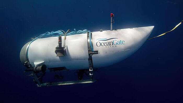
One voice echoes louder than most in this film, that of David Lochridge, the man who tried to stop it all before it began. A former submarine safety expert for the British Navy and a certified diver, Lochridge was brought in to oversee safety and engineering on OceanGate’s experimental deep-sea submersible, Titan. It was made from carbon fiber, a material never used for this kind of extreme-depth vessel.
Titan was marketed as revolutionary. Lochridge joined with the understanding that the sub would be inspected and certified by an independent third party — a process known in maritime engineering as “classing.”
But that assurance quickly dissolved. According to testimony in the documentary, it became clear that OceanGate co-founder and CEO Stockton Rush had little appetite for traditional safety oversight. Testing and caution seemed to take a back seat to being seen as a maverick innovator, and getting paying clients in the water and down to view the wreck of the Titanic.
The warning pings
Throughout the documentary, viewers hear a repeated motif: the high-pitched "ping" of Titan’s acoustic hull monitoring system. Designed to detect strain in the carbon-fiber shell, these sounds are not anomalies -- they're the microscopic fractures of carbon fiber under stress. In one chilling sequence, Rush takes Titan to nearly 4,000m, as the hull groans under pressure. Those pings, we learn, are the sound of the vessel’s structural integrity slowly unraveling.
Conflict between Lochridge and Rush grew, and Lochridge was sidelined from Titan's development following a disagreement over a botched dive piloted by Rush in another more traditional submersible. In 2018, Lochridge was, however, asked to inspect Titan. He then authored an internal report highlighting multiple red flags, such as visual evidence of flaws in the carbon fiber after pressure testing and the absence of essential non-destructive tests.
The Titan submersible. Photo: OceanGate
Authorities' inertia
Lochridge's recommendation was clear: Titan should not dive again until the risks were properly addressed. OceanGate’s response was telling. Lochridge was asked to sign off on the continued use of the sub. When he refused, he was fired and later sued for “revealing confidential information.” Lochridge filed a whistleblower complaint with the U.S. Occupational Safety and Health Administration (OSHA).
The documentary reveals that OSHA did start an investigation. But instead of providing immediate support to Lochridge, the process dragged on for months. As legal fees mounted and pressure from OceanGate grew, Lochridge withdrew his complaint. The OSHA probe then gathered dust in a case file at the agency.
As one expert notes, the case exposed a dangerous loophole. OceanGate’s classification of Titan as an “experimental” submersible in international waters allowed it to operate outside most safety authorities. In effect, there was no one with both the authority and the will to intervene, despite warnings from Lochridge and others. Titan went on to make over 90 dives and had hull replacements before the fatal event in 2023.
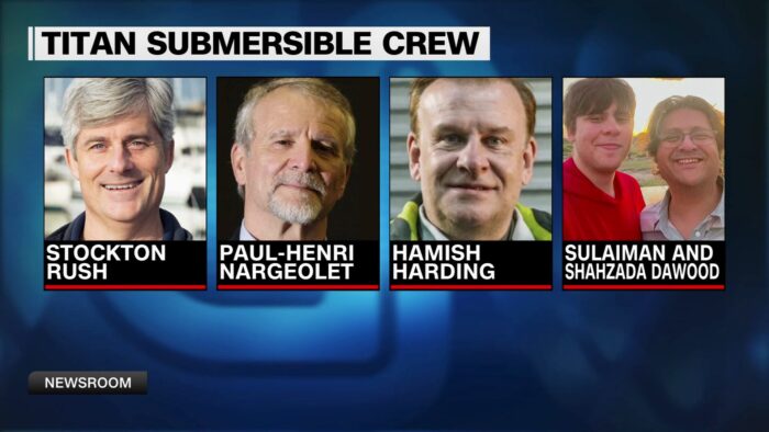
The five who were lost on the Titan. Photo: CNN
Unanswered questions
The film includes moving testimony from Sydney Nargeolet, daughter of veteran deep-sea explorer Paul-Henri Nargeolet, who perished on the vessel. But noticeably absent are the voices of those closest to the other victims, Hamish Harding and Shahzada and Sulaiman Dawood.
It also leaves unanswered how someone as experienced as Nargeolet came to overlook Titan's safety issues, or whether the passengers were ever fully briefed. The documentary also doesn’t include commentary from OceanGate board members or Rush’s wife, both of whom could have added vital context.
Yet while not a complete investigation, it does vividly capture the hubris at OceanGate’s core. In a striking recording, Stockton Rush shrugs off criticism, declaring to his team, "I’m not going to force people to join my religion."
By the time of Titan’s final dive in June 2023, most of the engineering team had either quit or been fired. What remained to hold the submersible’s hull together was, both literally and figuratively, blind faith.
]]>https://explorersweb.com/netflixs-titan-documents-the-deep-sea-disaster-many-saw-coming/feed/0Ousland and Colliard Complete Ellesmere Island Crossing
https://explorersweb.com/ousland-and-colliard-complete-ellesmere-island-crossing/
https://explorersweb.com/ousland-and-colliard-complete-ellesmere-island-crossing/#respondTue, 17 Jun 2025 18:29:06 +0000https://explorersweb.com/?p=105894
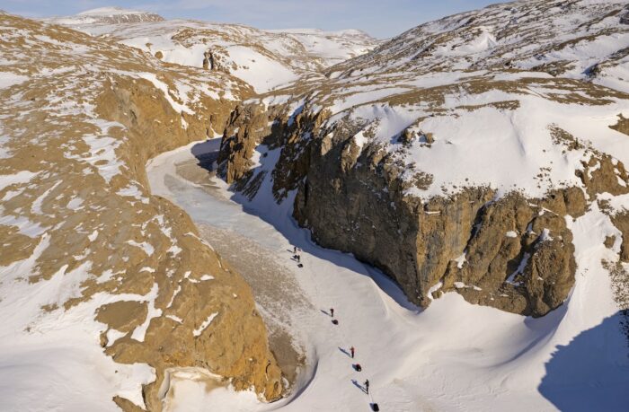
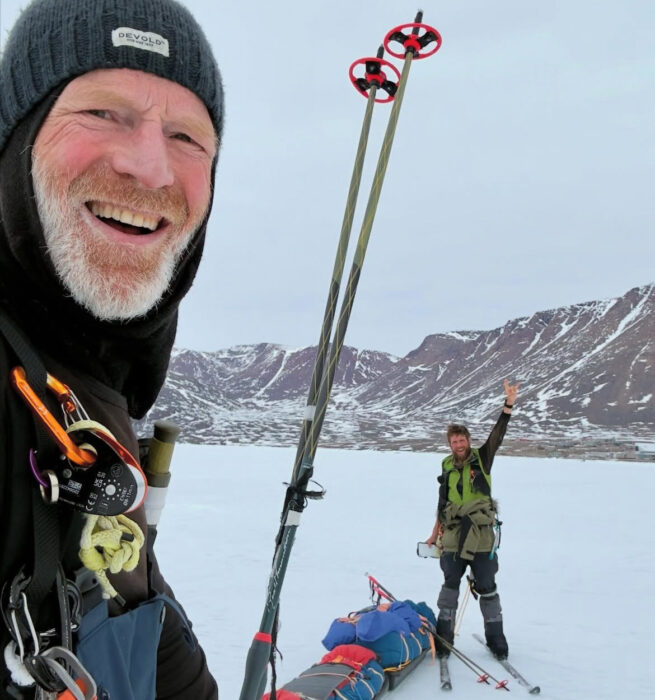
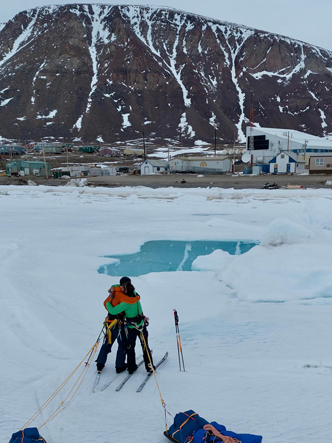
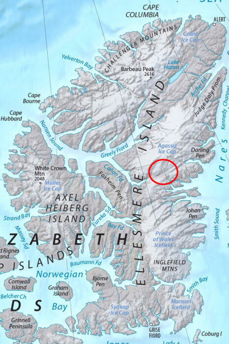
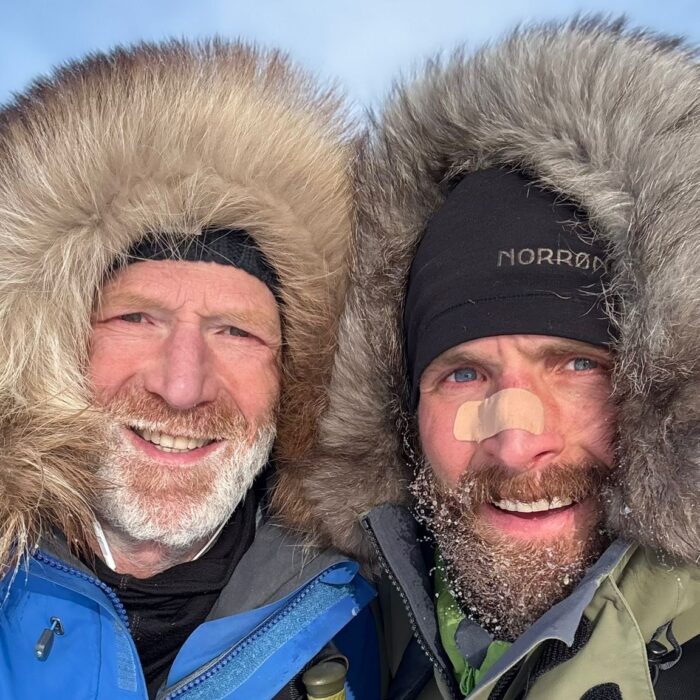
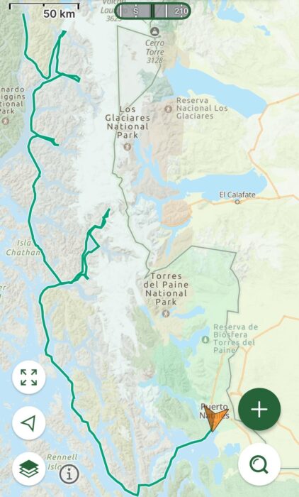
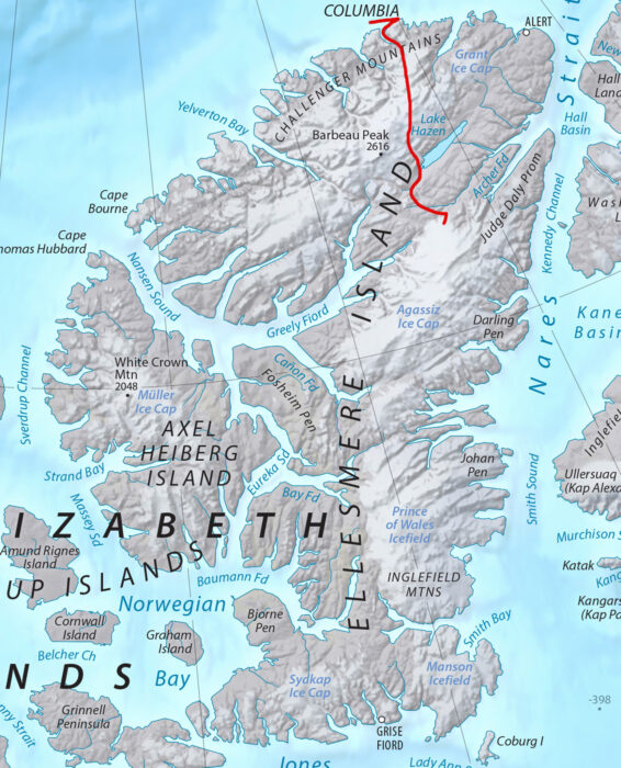
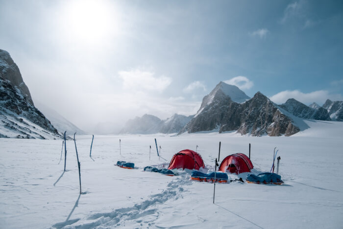
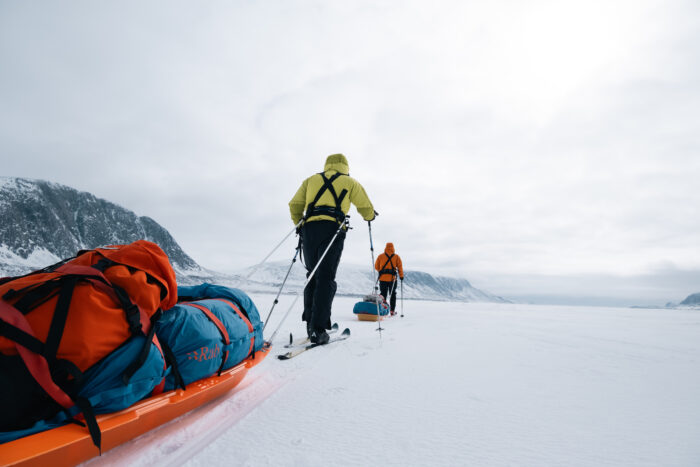
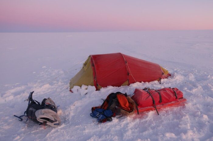
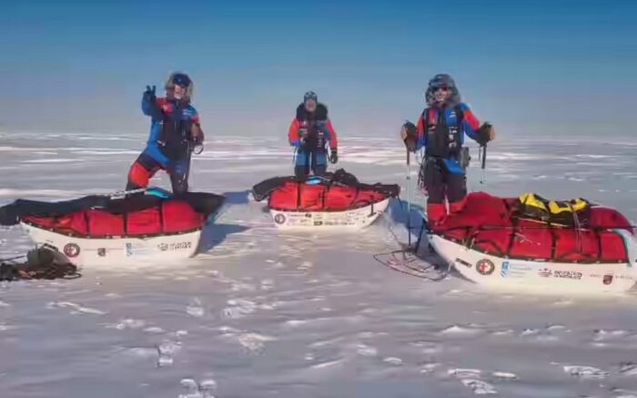
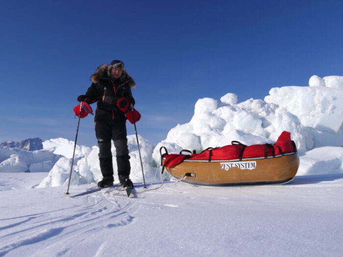
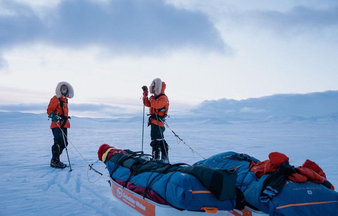
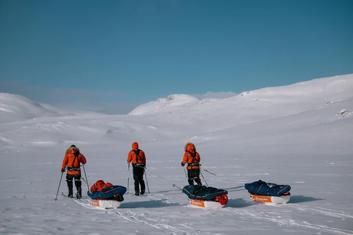
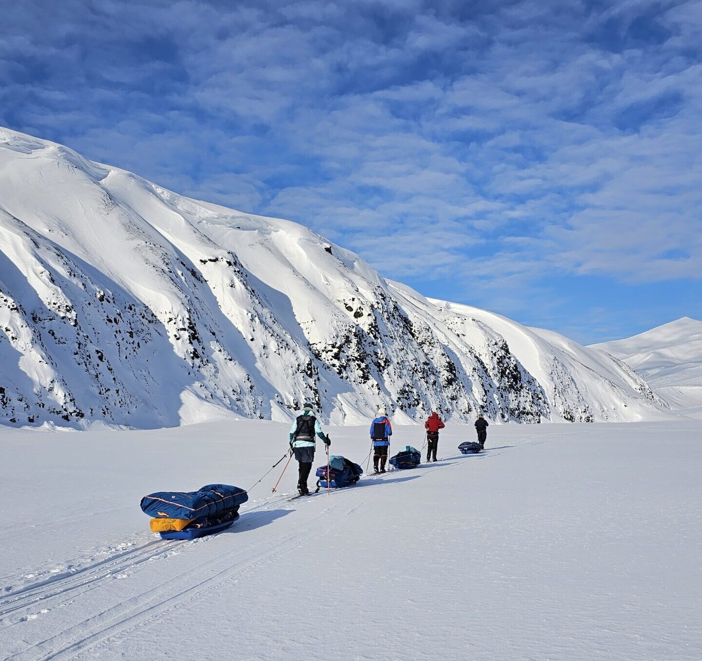
After 49 days and over 1,100km of skiing through Canada’s most remote terrain, Norwegian Borge Ousland and Frenchman Vincent Colliard have completed the first unsupported north-to-south crossing of Ellesmere Island.
The pair reached King Edward Point, the southernmost point on the island and the end of the crossing, on June 13. They then skied for two more days to reach the Inuit community of Grise Fiord on June 15.
The journey was part of the duo’s Ice Legacy project, a long-term initiative to traverse the world’s 20 largest ice caps. On this latest journey, they crossed the Grant, Agassiz, and Prince of Wales Ice Caps, leaving only four ice caps remaining in their global undertaking.
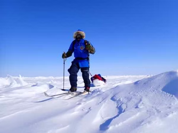
The expedition began on April 27, following a weather delay in Resolute Bay. From Ward Hunt Island, just off Ellesmere's northern coast, Ousland and Colliard skied east to Cape Columbia. This was the official start of the crossing and is the northernmost point of Ellesmere Island and North America. From here, they turned south into the island’s interior, hauling 130kg sleds behind them containing all their food and equipment, and foregoing any resupply or external support.
Early polar bear encounter and heavy loads
Borge Ousland in full flow. Photo: icelegacy.org
The pair's early days included an encounter with a polar bear, which approached within 12m of them, while on sea ice near Cape Columbia. Colliard described the bear as “very curious plus plus” before Ousland used a signal flare to scare it away.
Ousland and Colliard’s feat is a first in the history of Ellesmere Island expeditions. While two vertical traverses have previously been completed -- John Dunn’s in 1990 and Bernard Voyer’s in 1992 -- both had resupplies. In 2011, Jon Turk and Erik Boomer completed a full circumnavigation of Ellesmere by ski and kayak, but also relied on external support. Ousland and Colliard’s expedition is the first to complete a full north-south route unsupported.
Ousland and Colliard's GPS tracks. Map: icelegacy.org
Limited wind assistance
The route offered few flat sections, requiring repeated climbs and descents across glacial domes, riverbeds, canyons, and rocky terrain. Colliard reported persistent headwinds throughout the expedition, limiting their use of Beringer ski sails to just 60km. They thus completed most of the journey under their own power.
Borge Ousland from above. Photo: icelegacy.org
Progress remained steady, despite occasionally difficult conditions. Deep snow on the Grant Ice Cap slowed their early pace to about 14km per day, but once they reached the mostly snowless ground between the Grant and Agassiz Ice Caps, they detoured along the frozen Dodge River to preserve their sleds. There, they managed to increase the pace to 20km a day.
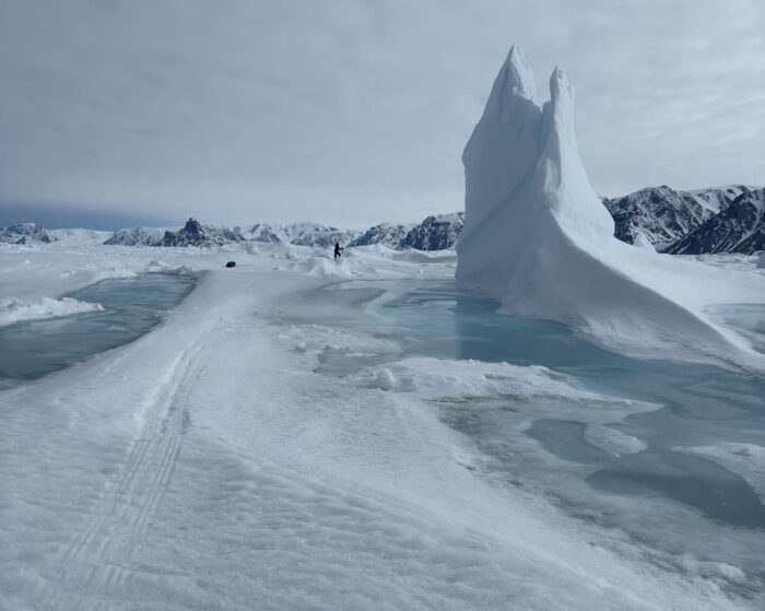
The expedition was not without risk. On day 26, while exiting the Agassiz Ice Cap, Colliard fell into a crevasse. He was uninjured, but later acknowledged that fatigue and overconfidence may have contributed to the incident.
The pass is a ribbon of snow that carves its way through steep slopes and deep canyons. At one point in the early 20th century, a glacier blocked the one route through the pass, and some explorers dubbed it Hell Cleft. Photo: Weber Arctic
Crossing Sverdrup Pass
After finishing the Agassiz Ice Cap, the duo faced a challenging descent and ascent through a steep gorge east of Canon Fiord, and then crossed Sverdrup Pass, named after Norwegian explorer Otto Sverdrup, who overwintered on Ellesmere from 1898-1902. The pass is often rocky and slow going. Ousland and Colliard, however, found it covered in snow, allowing them to continue skiing without having to portage their sleds.
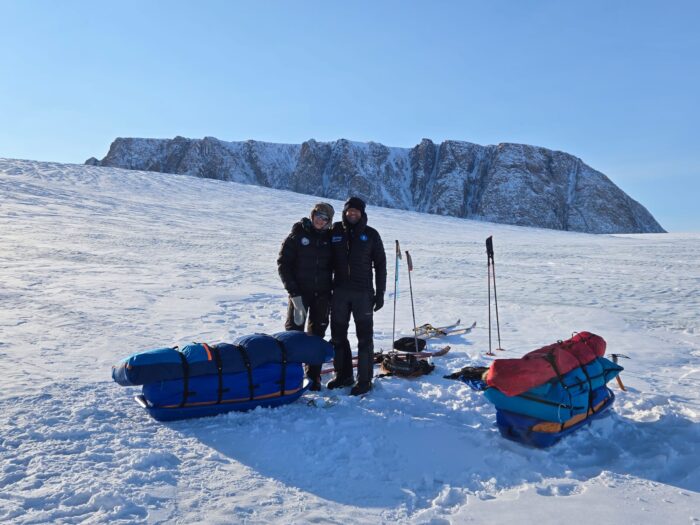
Ousland, left, and Colliard in good spirits as they reach Grise Fiord. Photo: icelegacy.org
After reaching and safely crossing the Prince of Wales Ice Cap, they descended through Makinson Inlet and Bentham Fiord and crossed the Manson Icefield and the Jakeman Glacier. Ousland and Colliard reached King Edward Point on June 13, officially completing the unsupported crossing. They then backtracked west for a final two-day push across sea ice to Grise Fiord, where they can recuperate and fly back out to civilization.
Photo: icelegacy.org
]]>https://explorersweb.com/ousland-and-colliard-complete-ellesmere-island-crossing/feed/0Ousland and Colliard Near Finish of Ellesmere Island Crossing
https://explorersweb.com/ousland-and-colliard-near-finish-of-ellesmere-island-crossing/
https://explorersweb.com/ousland-and-colliard-near-finish-of-ellesmere-island-crossing/#respondFri, 13 Jun 2025 12:02:51 +0000https://explorersweb.com/?p=105794
After 46 days, Borge Ousland and Vincent Colliard are down from the ice caps onto sea ice. They will likely complete the first unsupported north-to-south crossing of the island today by skiing a little east to King Edward Point, the southern tip of Ellesmere Island. They will then turn back west for a couple of days of skiing over the sea ice to the Inuit hamlet of Grise Fiord, the nearest community and airport.
Following their crossing of the Prince of Wales Ice Cap, the last of three major ice caps on their route, the experienced pair descended onto frozen Makinson Inlet, skiing eastward before turning south near Bentham Fiord.
Even in the High Arctic, the melt is now well underway. Photo: Icelegacy.org
Their route then continued across the Manson Icefield and the Jakeman Glacier, where a scientist perished in a crevasse two years ago. It is the only known fatality on an Ellesmere glacier.
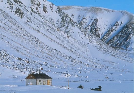
As of today, Ousland and Colliard have reached the coastline near Craig Harbour, a former Royal Canadian Mounted Police post now used as a seasonal hunting cabin. Craig Harbour lies on the north shore of Jones Sound, approximately 55 kilometers southeast of Grise Fiord.
Craig Harbour. Photo: Jerry Kobalenko
Originally established in 1922, the RCMP post at Craig Harbour was named after expedition commander Dr. John D. Craig. It was initially chosen for its protected harbour and proximity to Jones Sound. The post was closed in the 1930s, briefly reopened during the early Cold War in 1951, and has since remained uninhabited.
]]>https://explorersweb.com/ousland-and-colliard-near-finish-of-ellesmere-island-crossing/feed/0Duo Kayaks 720km Through Stormy Alaskan Waters
https://explorersweb.com/duo-kayaks-720km-through-stormy-alaskan-waters/
https://explorersweb.com/duo-kayaks-720km-through-stormy-alaskan-waters/#respondFri, 06 Jun 2025 13:09:15 +0000https://explorersweb.com/?p=105597
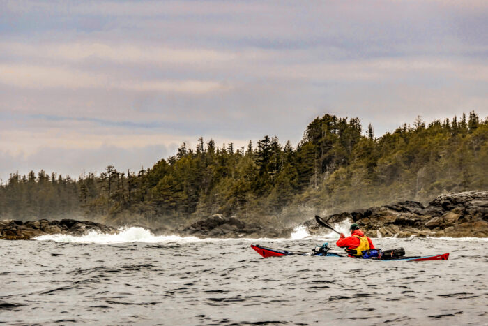
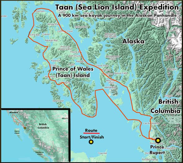
Canadian adventurer Frank Wolf and teammate David Berrisford have finished a 720km sea kayaking expedition through southeastern Alaska. Originally planned as a 900km circumnavigation of Prince of Wales Island, the pair had to change their route due to heavy spring storms.
"We had to sit out two of the first six days due to heavy southeast storms," Wolf reported. "We adjusted to our Plan B route...that would give us more cover for the 25 days we'd budgeted."
The trip marked the first Alaskan kayak expedition for both paddlers. Wolf has extensive experience along the British Columbia coastline, but Alaska was an entirely new challenge.
Photo: Frank Wolf
Their adapted route involved several open water crossings ranging from 8 to 14km, with strong currents and waves.
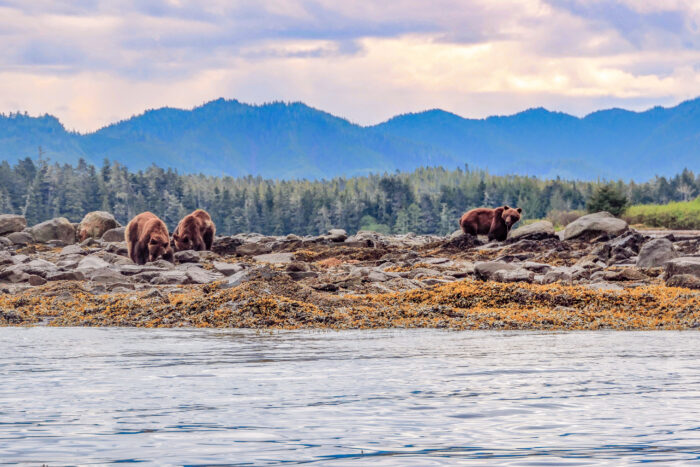
While the route changed, the rewards remained. The team paddled through temperate rainforest coastlines, camped in old-growth forests, and saw brown bears, orcas, humpback whales, porpoises, sea otters, and elk.
Brown bears along the shore. Photo: Frank Wolf
A nine-day storm
As the team neared the end of their journey, a series of powerful storms hit them just 90km from their final destination of Prince Rupert, British Columbia.
“We were pinned in just above Cape Fox in Alaska, where the entire fury of the notorious Hecate Strait slams,” Wolf reported. The strait is known for producing some of the largest waves in the world.
With time running out and no transport options available across the Canada and U.S. maritime border, the pair eventually asked members of the Nisga'a First Nation to pick them up during a brief break in the weather.
The final adjusted route. The team had originally planned to loop around Prince of Wales Island. Map: Frank Wolf
“There is no ferry or other transport service over the border, so in the end only the Nisga'a...could get us,” said Wolf. The Indigenous group has special status, allowing them to move freely over the borders.
Photo: Frank Wolf
]]>https://explorersweb.com/duo-kayaks-720km-through-stormy-alaskan-waters/feed/0Vincent Colliard Escapes Crevasse Fall on Ellesmere Island
https://explorersweb.com/vincent-colliard-escapes-crevasse-fall-on-ellesmere-island/
https://explorersweb.com/vincent-colliard-escapes-crevasse-fall-on-ellesmere-island/#respondThu, 05 Jun 2025 12:05:07 +0000https://explorersweb.com/?p=105556
Ten days ago, while exiting the Agassiz Ice Cap on Canada’s Ellesmere Island, Vincent Colliard fell into a crevasse. He shared details of the incident yesterday on social media. The French polar traveler escaped without injury but described the event as “a scary moment where life’s balance was on the edge."
Colliard is 38 days into a 1,100km unsupported ski traverse of Ellesmere Island, traveling from north to south with Norwegian veteran Børge Ousland. In video footage posted to Instagram, Colliard appears trapped beside his sled in a tight crevasse. As the camera pans upward, the clear blue sky is visible far above, indicating he had fallen a significant distance.
The accident occurred on day 26 of their journey while on a glacial arm at the edge of the ice cap. Reflecting on the fall, Colliard acknowledged a lapse in caution.
"We made big mistakes. We let our guard down as we were tired — 26 days of hard labor on the body — and maybe acted too confidently about what we were doing."
He emphasized that they had been following safety protocols to mitigate crevasse hazards: "We know the drills though... blocking knot connected to the back of the sleds, max tension on the rope, easy access to the crevasse rescue kit...Our guard is right back up with triple precautions."
Many glaciers on Ellesmere Island have few crevasses compared to alpine glaciers, though crevasses are still present. Snow bridges in the frigid, windy High Arctic also tend to be firmer, but at this milder time of year, they would have softened up.
Some small Ellesmere ice caps, like the one above, may have no crevasses, but not all are this benign. Photo: Jerry Kobalenko
While crevasse falls are rare during polar expeditions, they do occur. In 2021, Belgian polar guide Dixie Dansercoer died after falling 25 meters into a crevasse on the Greenland Ice Sheet. And in 2023, University of Alberta professor Maya Bhatia lost her life on the Jakeman Glacier on southern Ellesmere Island when she fell into a moulin while conducting scientific fieldwork. It is the only known death on an Ellesmere ice cap.
Entering the final phase
Despite the near miss, Collaird appears to be in good spirits: "We are still on the way to attempt an unsupported full crossing of Ellesmere Island. It was a magical moment to see the light of the sun again and away from the darkness of that hole.
The approximate site of the fall. Map Source: shadedrelief.com
After successfully crossing Sverdrup Pass, Colliard and Ousland are now traversing the Prince of Wales Ice Cap — the final major ice cap of their expedition. Yet, challenges remain. Once they descend from the ice, their route will take them over the frozen channels of Makinson Inlet and Bentham Fiord. From there, they will navigate a complex system of glaciers and ice fields en route to their final destination: King Edward Point, the southernmost tip of Ellesmere Island.
]]>https://explorersweb.com/vincent-colliard-escapes-crevasse-fall-on-ellesmere-island/feed/0Ousland and Colliard Reach Final Ice Cap
https://explorersweb.com/ousland-and-colliard-reach-final-ice-cap/
https://explorersweb.com/ousland-and-colliard-reach-final-ice-cap/#respondSat, 31 May 2025 16:55:10 +0000https://explorersweb.com/?p=105452
Børge Ousland and Vincent Colliard are closing in on a major milestone in their sled journey across Canada’s northernmost island. Now on Day 33 of their journey, the pair are climbing onto the Prince of Wales Ice Cap -- the third and final ice cap on their 1,100km unsupported ski crossing of Ellesmere Island from north to south.
The expedition, now over a month underway, has challenged their extensive polar experience, first with deep snow and more recently with rugged, rocky terrain. In the past week, a storm on Day 30 brought strong winds and heavy snow, prompting the pair to take their first full rest and repair day. Conditions improved the next day, allowing them to resume the journey south.
It still looks like winter on the high ice caps of Ellesmere Island, although the temperature is warmer. Photo: icelgacy.org
Sverdrup Pass success
The duo had a "very good day,” reported their expedition liaison, Lars Ebbesen. “They passed Sverdrup Pass on a flat and good surface. All the snow lately gave them a good base to ski on.”
Ousland and Colliard are making good progress. Photo: icelegacy.org
Poised at the edge of the Prince of Wales Ice Cap, Ousland and Colliard are steadily advancing toward one of the last great firsts in polar exploration. After descending the ice cap, their planned route will trace the frozen Makinson Inlet and Bentham Fiord, before weaving through a succession of ice fields and glaciers en route to Ellesmere Island’s southernmost tip, King Edward Point.
]]>https://explorersweb.com/ousland-and-colliard-reach-final-ice-cap/feed/0First Ascent of a Big Wall on Baffin Island
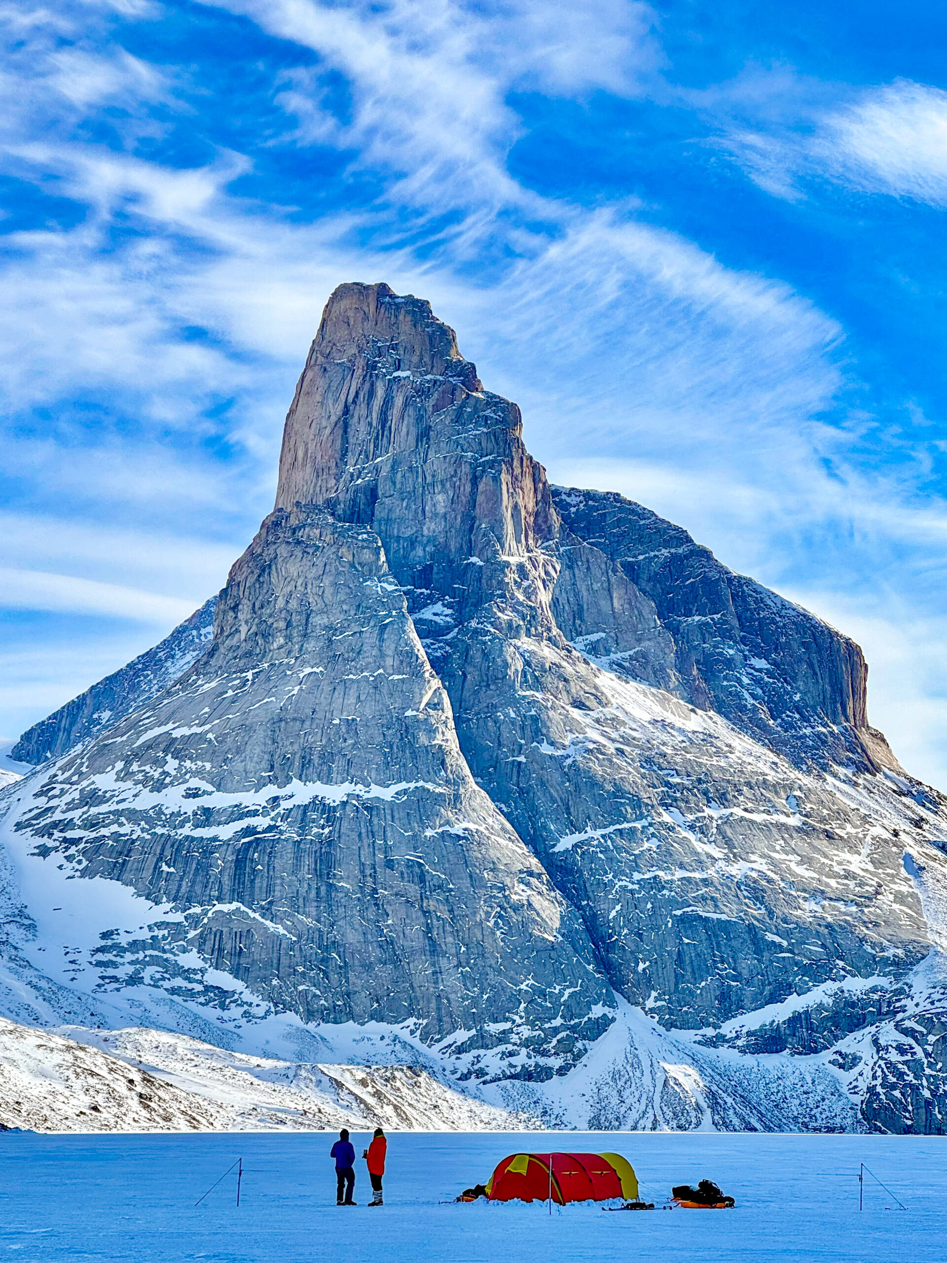
https://explorersweb.com/first-ascent-of-a-big-wall-on-baffin-island/
https://explorersweb.com/first-ascent-of-a-big-wall-on-baffin-island/#respondWed, 28 May 2025 12:03:15 +0000https://explorersweb.com/?p=105371
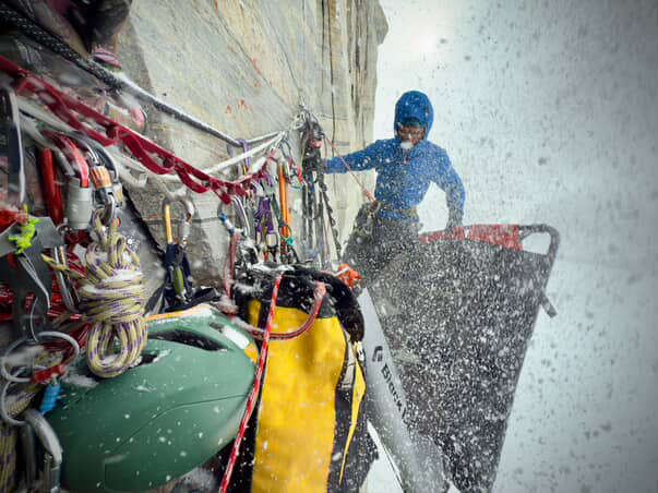
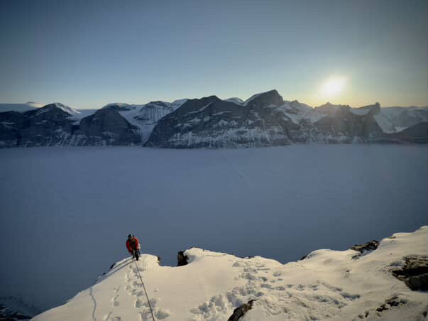
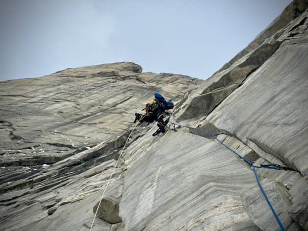
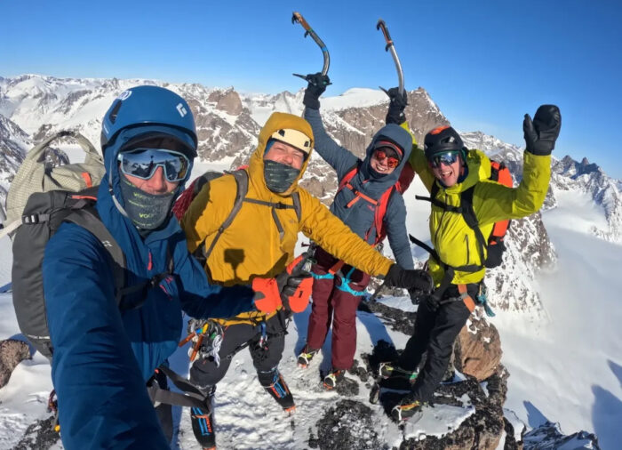
High on the remote granite cliffs of Sam Ford Fiord, Baffin Island, climbers Erik Boomer and Ky Hart have completed a new big wall route in one of Canada’s most isolated regions. The 23-day ascent, which they named Sikunga Express (WI3 M7 5.10 A3+ Grade VII, 975m, 19 pitches), tested their mettle through cold temperatures, storms, and sustained technical difficulties.
Near the top of the climb, with only one usable rope remaining and over 500m of exposure beneath them, the pair were pinned to their portaledge as strong Arctic winds hammered the wall. It was one of the most exposed moments of a trip defined by commitment and the need for well-rounded climbing skills.
Boomer and Hart had traveled to the east coast of Baffin Island in search of unclimbed terrain. They found it on a sweeping face just north of Clyde River on the southwest-facing side of photogenic Sam Ford Fiord, considered the Yosemite Valley of the Canadian Arctic.
Full commitment
Exposure high on the wall. Photo: Erik Boomer/Ky Hart
Their approach was exploratory from the outset.
“We kind of showed up there with a loose plan of climbing something new,” Hart said. “This cliff seemed to have the least amount of [water] runoff and was seemingly steep.”
Temperatures were cold during the early stages of the climb, with daily highs around -7˚C and averages around -15˚C.
“There was a good 60m ice pitch at the very beginning,” Hart recalled. “Those first couple of days, we had a high of seven degrees.”
From that initial ice pitch, the route climbed through increasingly complex terrain, demanding a combination of alpine, mixed, and aid skills. The pair encountered loose rock and challenging aid sections that pushed their skills and gear.
“Every style of aid [climbing], clean to nailing, to copperheads hooking,” said Boomer. The lower pitches were also prone to being loose. “Rampy ledges that would come off in the beginning and, you know, send down some rocks,” Hart added.
Pinned to the wall
The pair faced snow and violent winds while sleeping on the wall. Photo: Erik Boomer/Ky Hart
After a mid-route snowstorm forced a temporary pause, Boomer and Hart pushed higher, only to be caught in severe wind while camped on one of their most exposed bivouacs right near the prow of the face.
“The wind started picking up,” Hart said. “It was funny at first until we got picked up on the ledge and put back down.”
"We were kind of hanging on for dear life in that ledge during that windstorm, just getting tossed around and just hanging onto the straps," Boomer added.
Topping out on Sikunga Express, with frozen Sam Ford Fiord below. Photo: Erik Boomer/Ky Hart
Unable to move safely, the two spent the day pinned to the wall, their portaledge buffeted by strong gusts. As the storm wore on, they took stock of their dwindling equipment.
“We had core shot three out of our four ropes,” said Hart. “The gear was getting thin.”
Despite the conditions, they continued upward and reached the summit just as the weather warmed dramatically.
“It was a huge swing,” Boomer said. “We were definitely dodging a lot of rockfall.”
20 nights
The komatik (Inuit sled) that brought all their equipment into the remote fiord. Photo: Erik Boomer/Ky Hart
In total, Boomer and Hart spent 20 nights on the wall. Including the time spent route finding and establishing the lower pitches, the full expedition spanned 23 days from May 1 to May 23.
With a snowmobile and komatik (wooden sled), they had their own transportation in one of the most remote climbing areas in Canada.
“We were able to insert and extract ourselves,” Boomer explained. “Cruise around and choose our formation a little bit more relaxed.”
Steep terrain ahead. Photo: Erik Boomer/Ky Hart
Their route adds a new line to the vast granite walls in this part of Baffin Island. Despite a reasonable amount of climbing activity in the region in recent decades, it suggests there is still much potential for exploratory climbing. The climb also marks a further step in Boomer's transition from elite whitewater kayaker to Arctic traveler and now big wall climber.
“Overall, it was a sweet trip,” Boomer said. “We wanted to do a new line and we did it.”
]]>https://explorersweb.com/first-ascent-of-a-big-wall-on-baffin-island/feed/0Ousland and Colliard Cross Second Ice Cap, Rocky Terrain Ahead
https://explorersweb.com/ousland-and-colliard-cross-second-ice-cap-rocky-terrain-ahead/
https://explorersweb.com/ousland-and-colliard-cross-second-ice-cap-rocky-terrain-ahead/#respondMon, 26 May 2025 17:40:31 +0000https://explorersweb.com/?p=105283
Borge Ousland and Vincent Colliard are now 28 days into their 1,100km bid to complete the first unsupported north-to-south ski crossing of Ellesmere Island. The pair began their journey from Ward Hunt Island on April 27 after a long weather delay. They have recently finished the Agassiz Ice Cap, the second of three ice caps they must traverse.
Progress has been good despite varied conditions. Early on, they faced broken sea ice along the north coast and a close encounter with a polar bear before reaching Cape Columbia, the northern tip of Ellesmere and their official starting point. They then skied south, moving inland over the Grant Ice Cap. Hauling 130kg sleds at over 1,000m elevation, the experienced arctic travelers managed around 14km per day despite deep, soft snow.
As Ousland and Colliard left the Agassiz Ice Cap, they have two areas of rocky ground to cross, circled in red. The bottom circle shows Sverdrup Pass. The red line traces their approximate route so far. Map Source: Shadedrelief.com
Rocky terrain ahead
More recently, they crossed a 90km stretch of sparsely snow-covered ground between the Grant and Agassiz Ice Caps. To avoid damaging the bottom of their plastic sleds on exposed rocks, they detoured along the frozen Dodge River. Though the riverbed proved ill-defined and rocky, scattered snow patches allowed enough cover for progress. They even increased their pace to around 20km per day.
Ousland and Colliard in good spirits. Photo: icelegacy.org
After finishing the vast Agassiz Ice Cap, Ousland and Colliard must navigate two tricky sections of bare ground that separate the Agassiz from the Prince of Wales Ice Cap. The first, a steep gorge which they skied through yesterday in a 14km day, lies east of Canon Fiord. There was sufficient snow cover not to require portaging of sleds on foot, or the use of ropes and crampons to overcome sections of steeper ground. They descended from 850m down to 350m, and up again to 700m, traveling through the narrow gorge.
File image of Jerry Kobalenko and teammate portaging their sleds on a snowless section between Copes Bay and Canon Fiord, near Ousland and Colliard's current position. Photo: Jerry Kobalenko
Following this, Ousland and Colliard's intended route will follow the Sven Hedin and Benedict Glaciers, before crossing rocky ground across Sverdrup Pass. This pass is named after Ousland's compatriot, Norwegian explorer Otto Sverdrup, who overwintered on Ellesmere between 1898 and 1902. During this period, Sverdrup discovered Axel Heiberg, Amund Ringnes, and Ellef Ringnes Islands, known together as the Sverdrup Islands, and mapped large parts of Ellesmere.
The pass, which acts as a wind tunnel, is a ribbon of snow and ice (or often rock and ice) that carves its way through steep slopes and deep canyons. At one point in the early 20th century, a glacier blocked the one route through the pass, earning it the name Hell Cleft among the explorers of that era. Photo: Weber Arctic
Wally Herbert's struggle
In 1967, Wally Herbert, Roger Tuft, and Allan Gill dogsledded through Sverdrup Pass. The three-month journey from northwest Greenland and across Ellesmere was a shakedown trip for Herbert's Arctic Ocean crossing the following year. In his book Across the Top of the World, Herbert wrote that his Inuit friends had warned that "if there was little snow in the valley, we would run into trouble."
Borge Ousland from above. Photo: icelegacy.org
And that's exactly what Herbert found, as the lack of snow and slow progress in Sverdrup Pass forced them to drastically ration their food. Ousland and Colliard will no doubt hope that they find more snow cover than Herbert did half a century ago.
]]>https://explorersweb.com/ousland-and-colliard-cross-second-ice-cap-rocky-terrain-ahead/feed/0A 32-Day Kayak Journey Through Southern Patagonia
https://explorersweb.com/a-32-day-kayak-journey-through-southern-patagonia/
https://explorersweb.com/a-32-day-kayak-journey-through-southern-patagonia/#respondWed, 21 May 2025 16:33:47 +0000https://explorersweb.com/?p=105170
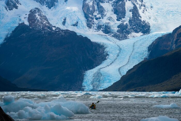
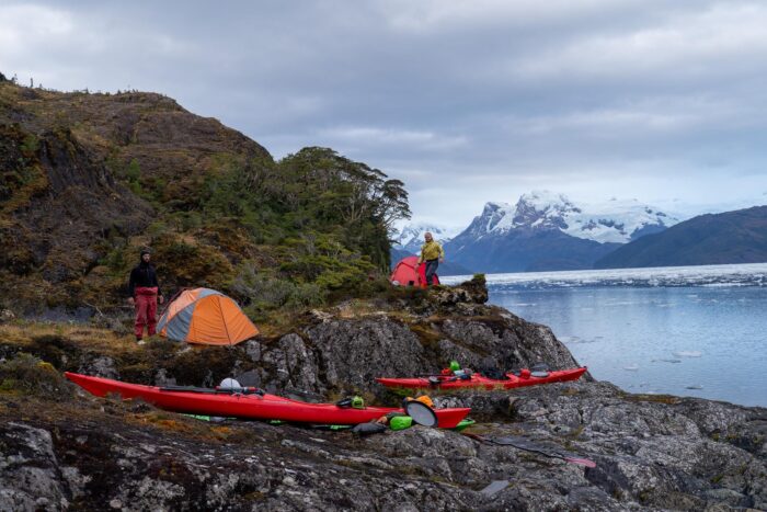
Earlier this month, three kayakers completed a 32-day expedition through remote southern Patagonia. They covered nearly 900km of isolated fiords and rugged coastline.
Mathew Schweizer and Brody Duncan of New Zealand, along with Andy Gill of Scotland, began in Puerto Edén, a remote fishing village in the Magellanes region of Chile.
Before setting out, the group underwent an official gear inspection from the Chilean Navy.
“We had a naval inspection to check all our gear and get signed off… We needed to get permits from the Navy,” said Schweizer.
An outline of the route. Photo: Mathew Schweizer
South America's largest glacier
Before heading south, the team paddled north from Puerto Edén to the Pio Xi, the largest glacier in South America.
“Absolutely huge, about five kilometers wide,” Schweizer noted.
They explored nearby fiords but had to turn back because of dense ice.
“The amount of ice that was coming out was just too much for us to paddle up into. Just big big ice pack.”
Their journey included an overland portage through a lake system.
“It was pretty hard work, unloading all the gear and hiking through some hard terrain, and then carrying kayaks up and over hills and into these lake systems,” Schweizer said.
Later, they entered Peel Fiord, a vast network of channels stretching roughly 70km. At its northern end lies Seno Andrew Fiord, which Schweizer described as a standout moment. “Just amazing. Four or five glaciers running straight down into Seno Andrew [Fiord].”
Seno Andrew Fiord. Photo: Mathew Schweizer
The coastal fiords of Patagonia, located in the Magallanes region of southern Chile, are among the most remote and least inhabited areas of South America. Known for challenging weather and dramatic glacial landscapes, the region is accessible only by boat or on foot.
Rough paddling weather
Adverse weather was a challenge throughout the 32-day trip.
“Probably four-and-a-half-foot waves,” Schweizer recalled of one particularly rough stretch.
The team also faced equipment failures. “Broken holes and tents, broken sleeping mats, well, my broken sleeping mat had fifteen or so puncture repairs on it. It just failed on me.” Strong winds also shredded their tarp.
Camped for the night. Photo: Mathew Schweizer
In total, they covered 850 to 900km, and ended in Puerto Natales, a port city a few hours of Punta Arenas, the jumping off point for flights to Antarctica.
The isolation of the route demanded complete self-reliance.
“Once you start paddling from Puerto, you have no other villages, no other civilization to come across…There's no help. There are no people out there,” said Schweizer.
]]>https://explorersweb.com/a-32-day-kayak-journey-through-southern-patagonia/feed/0Arctic Roundup: A Mythical Quest Ends in Greenland; Ellesmere Trek Continues
https://explorersweb.com/arctic-roundup-end-of-the-trail-for-most-except-on-ellesmere/
https://explorersweb.com/arctic-roundup-end-of-the-trail-for-most-except-on-ellesmere/#respondMon, 19 May 2025 12:00:44 +0000https://explorersweb.com/?p=105033
As snow disappears from the land, even in the High Arctic, most northern ski expeditions have wrapped up. This week’s roundup brings fresh updates from amajor ski crossing still unfolding on Ellesmere, newly named first ascents on Baffin, the end of several Northwest Passage treks, as well as long awaited details on an intriguing journey in northwest Greenland.
Ellesmere Island
Borge Ousland and Vincent Colliard have just reached the second ice cap on their 1,100km attempt at the first unsupported north-to-south ski crossing of Ellesmere Island. Three weeks into the expedition, they are now at the edge of the vast Agassiz Ice Cap on the island’s central eastern side.
As they left the Grant Ice Cap, they spotted muskox in the distance and numerous wolf tracks, and their pace increased to about 20km per day. The 90km stretch between the Grant and Agassiz Ice Caps had minimal snow cover, so to avoid damaging their sleds on exposed rocks, Ousland and Colliard chose a detour along the frozen Dodge River.
They found the river system poorly defined, with a wide riverbed filled with gravel and stones. Scattered snow patches provided just enough coverage for travel.
The route covered by Ousland and Colliard so far. Grise Fiord, at the bottom, is their final destination. Map Source: Shadedrelief.com
Last week, the Royal Geographical Society in London awarded Ousland the 2025 Founder’s Medal in recognition of his "unparalleled contributions to polar exploration." Past winners include adventure giants such as Knud Rasmussen, Douglas Mawson, and Chris Bonington. Ousland will still be out on the ice during the award ceremony in early June, so he will rely on his satellite phone to relay his acceptance speech back to his team in Norway.
Borge Ousland in good spirits. Photo: Ice Legacy
Northwest Passage
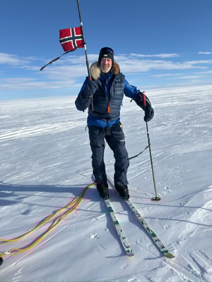
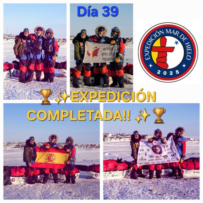
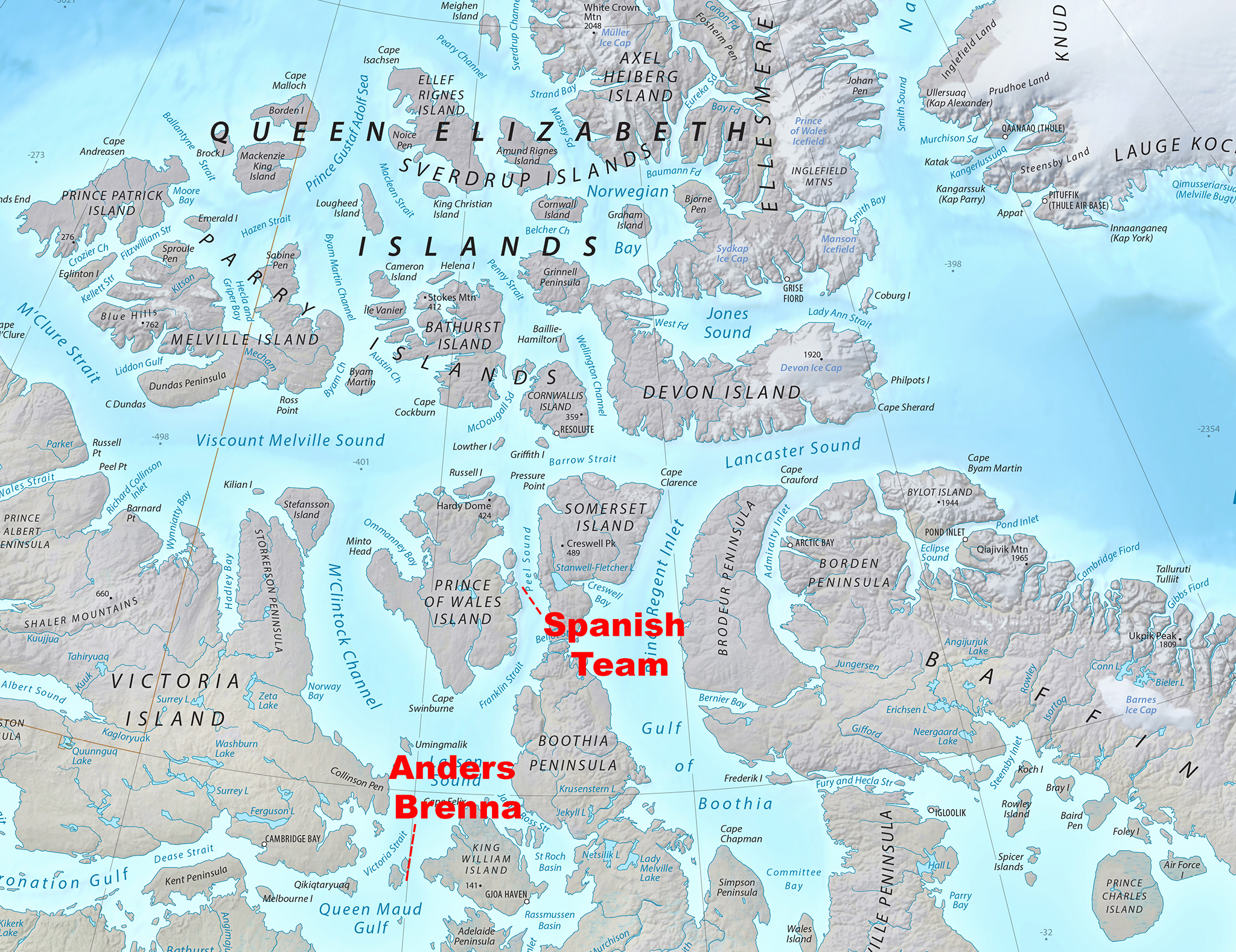
Spaniards Jose Trejo, Sechu Lopez, and Francisco Mira completed their sled journey to Gjoa Haven on May 13. After an initial charter flight to Prince of Wales Island, they skied approximately 600km over 39 days. Despite occasional poor visibility, deep snow and strong winds, the three-man team made light work of their route, covering more than 20km on most days.
The Spanish Northwest Passage team in Gjoa Haven. Photo: https://mardehielo2025.com/
Further east, on May 10, Norwegian Anders Brenna completed his shortened route from Gjoa Haven to Cambridge Bay, racking up around 400km in 50 days. Brenna reported difficult snow and ice conditions along the way, but it's not clear what slowed his progress down to eight kilometers per day.
Baffin Island
Last week, we updated on the British team of Tom Harding, Ben James, Leanne Dyke, and James Hoyes which made seven first ascents on peaks east of Pangnirtung. After consulting with locals, the peaks have now been named as Uppijjuaq (1,823m), Minas Tirith (1,950m), Aqviq (1,860m), Inutuaq (1,637m), Ukaliq (1,532m), Uvingajuq (1,615m), and Atangiljuq (1,600m).
Untrodden peaks. Photo: Ben James
Greenland
Camilla Ringvold’s kite-skiing group reached their finish point in the Bowdoin Fjord near Qaanaaq on May 15. In 23 days, they covered around 1,600km, putting in big days up to 280km in the final week.
The snowkiting team at their finish near Qaanaaq. Photo: Camilla Ringvold
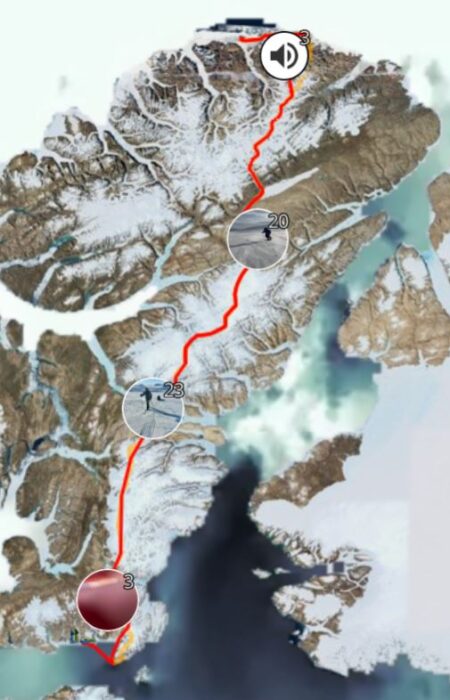
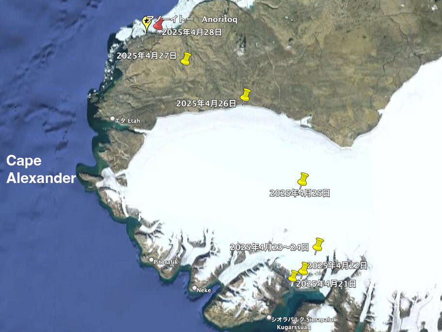
After a long period of radio silence, we have word that Japanese arctic adventurer Yasu Ogita has completed a 15-day, 400km solo ski journey through northwest Greenland to reach a rock near a place known as Anoritoq. The rock is central to an Inuit legend.
Yasu Ogita's route over the Inland Ice from Siorapaluk to Anoritoq. Photo: Yasu Ogita
Ogita set out from Siorapaluk on April 21 after a week-long delay due to transport issues. His route led him up a steep glacier and across a remote section of the Greenland Ice Sheet to an elevation of 1,200m, before descending through deep valleys toward Anoritoq. He took this traditional glacier route to avoid the open water off Cape Alexander.
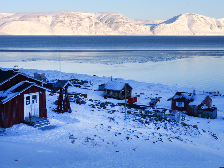
Siorapaluk, the world's northernmost civilian settlement. Photo: Yasu Ogita
Ogita’s main goal was to find the “Mother’s Stone.” Everyone in Greenland knows this legend about the mother and her polar bear son.
A woman who used to live in Anoritoq lost her son, the only provider, so she asked the hunters to give her a polar bear embryo when they killed a pregnant mother bear. So they did, and she raised him as her own son. When he grew, he started to catch seals for his mother. She painted a black spot on his side, but only on one side, because she did not have enough soot.
One day, when the son went far away in search of seals in the middle of a long polar night, a stranger from another settlement did not notice the black spot, because he only saw the other side. He killed the bear.
When the mother learned about her son’s death, she cried so hard that her tears froze on her cheeks, and her body turned into a rock. When Inuit hunters visit, they smear the rock with seal blubber to nourish her spirit and honor her eternal vigil.
On April 29, Ogita reached the Mother’s Stone. “I was deeply moved,” he reported via satellite phone. “I was able to reach my destination, Anoritoq, without any problems, and I...smeared [the rock] with seal blubber.”
Somewhere near Anoritoq. Photo: Yasu Ogita
For Ogita, the expedition was a cultural pilgrimage. With Siorapaluk’s population dwindling to around 40 residents and traditional hunting practices in steep decline due to environmental and regulatory pressures, legends like this risk disappearing forever.
Yasu Ogita enjoys clear weather in camp. Photo: Yasu Ogita
The return journey for Ogita was not straightforward, with deteriorating weather and whiteout conditions. Despite this, Ogita completed the round trip on May 5 without issue, exactly two weeks after departing. He now plans to collaborate with artist Nana Inoue to turn the story of the Mother’s Stone into a picture book.
The legendary rock, as seen earlier by anthropologist Christiane Drieux. Photo: Christiane Drieux
]]>https://explorersweb.com/arctic-roundup-end-of-the-trail-for-most-except-on-ellesmere/feed/0A 1,700km Bike and Canoe Journey Through Northern Canada
https://explorersweb.com/a-1700km-bike-and-canoe-journey-through-northern-canada/
https://explorersweb.com/a-1700km-bike-and-canoe-journey-through-northern-canada/#respondTue, 13 May 2025 12:33:21 +0000https://explorersweb.com/?p=104653
In two weeks, Dave Greene and Gaia Aish will set out on a 1,700km canoe and bike journey through northwestern Canada to the shores of the Arctic Ocean.
The pair, who are life partners as well as teammates, will start biking from the Yukon-British Columbia border. After 100km, they will retrieve their canoe at Johnsons Crossing, a small settlement at the head of the Teslin River.
They then swap pedal power for paddle power, stowing their bikes in the canoe. Over 12 days, they will canoe 750km down the Teslin and Yukon Rivers to Dawson City. From this famed Gold Rush town, the pair will reassemble their bikes and ride 940km north over the Dempster Highway to Tuktoyaktuk in the Northwest Territories.
Photo: Dave Greene
The Dempster Highway is Canada’s only road north to the Arctic Ocean. As they cycle north on this gravel road, Greene and Gaia will cross two mountain ranges -- the Ogilvie and the Richardson -- before descending to the Mackenzie River delta at Inuvik and ending in Tuktoyaktuk. On the first section of the Dempster, the pair will hike in the striking Tombstones range.
The Dempster Highway climbs through the Tombstone Mountains in Canada's Yukon Territory. Photo: Shutterstock
Greene and Gaia are based in Nova Scotia and are currently on sabbatical from their jobs in education. Last month, Greene completed a 400km ski crossing from Akulivik to Kangiqsujuaq in northern Quebec. Before that, he had undertaken nine canoe, ski, or bike journeys. Aish has previously canoed in Labrador. They estimate their trip will take 30 days.
]]>https://explorersweb.com/a-1700km-bike-and-canoe-journey-through-northern-canada/feed/0Arctic Roundup: Passing Magnetic North, Deep Snow, and Siberian Cold
https://explorersweb.com/arctic-roundup-passing-magnetic-north-deep-snow-and-siberian-cold/
https://explorersweb.com/arctic-roundup-passing-magnetic-north-deep-snow-and-siberian-cold/#respondSat, 10 May 2025 14:08:07 +0000https://explorersweb.com/?p=104802
Sled expeditions remain underway on Canada's Ellesmere Island and in the Northwest Passage, while other journeys have recently concluded in Siberia, Iceland, and on Baffin Island. The Arctic spring is at its peak. The long days are brilliantly sunny. You can still get frostbite in a wind, but on a calm day, even just an undershirt may be too warm.
Ellesmere Island
Two weeks into their 1,100km attempt at the first unsupported north-to-south ski crossing of Ellesmere Island, Børge Ousland and Vincent Colliard are now well inland. They traveled south over frozen Markham Fiord to the Grant Ice Cap -- the first of three that they are traversing. Hauling 130kg sleds through deep snow up to the 1,400m-high ice caps of northern Ellesmere, their pace has slowed to a still-impressive 14km on some days.
The experienced pair is currently near the Henrietta Nesmith Glacier, approximately 30km west of Lake Hazen (the world's largest High Arctic lake) and 30km east of 2,616m Barbeau Peak, the highest mountain in North America east of the Rockies.
Above: Barbeau Peak. Below: Henrietta Nesmith Glacier. Both: Jerry Kobalenko
Northwest Passage
The changing location of the North Magnetic Pole. Photo: British Geological Survey
Spaniards Jose Trejo, Sechu Lopez, and Francisco Mira are now 34 days into their sled journey to Gjoa Haven. After an initial charter flight to Prince of Wales Island, they have skied approximately 490km. As of May 8, they are approaching the Tennent Islands, just off the coast of King William Island. They will then navigate around these to their final destination, Gjoa Haven. Despite strong winds and low visibility on some days, they’ve maintained a steady pace of 20–25km per day over the past week.
Notably, on day 29, the trio reached the historic point where James Clark Ross first identified the Magnetic North Pole in 1831. This is the location on Earth where a compass needlepoints straight down, as the planet’s magnetic field enters the ground vertically. This point is not fixed, however, as the Magnetic Pole drifts constantlyand is now located in the Arctic Ocean north of Siberia, an astonishing 15° farther north than it was in Ross’s day.
Further east, Anders Brenna is nearing the end of a long and markedly shortened expedition. Originally aiming to ski 1,100km from Gjoa Haven to Glenelg Bay on northern Victoria Island, he traveled slowly and ultimately hadto adjust course toward Cambridge Bay, trimming the journey to just 400km. He is expected to finishsoon.
Baffin Island
Photo: Ben James
The British team of Tom Harding, Ben James, Leanne Dyke, and James Hoyes began with a false start on April 7, when high winds forced them to abandon their initial snowmobile drop-off at Kingnait Fiord, east of Pangnirtung. They resumed on April 10 from a new point near the park boundary and spent three days hauling gear up to the Nerutusoq Glacier.
From there, they made two first ascents before moving to the Fork Beard Glacier. Here, they completed two more first ascents and attempted a third summit unsuccessfully. They abandoned their original goal, the Gateway Glacier, due to glacial retreat and insufficient snow cover. Instead, they remained on the Fork Beard Glacier, where they climbed three additional peaks, all believed to be previously unclimbed.
Photo: Ben James
In total, the Britons made seven possible first ascents. Some neighboring summits had been climbed on one of those peaks. The rest were located near little-visited glaciers. Access to this part of Eastern Baffin is rare due to logistical challenges, particularly in summer when heavy gear transport is difficult on foot. Winter travel using skis and pulks with good snow cover made these ascents possible. Most visitors focus on well-known peaks like Mount Thor and Mount Asgard to the west.
The team completed its journey with a four-day ski out via the Weasel River Valley and Pangnirtung Fiord, returning to the hamlet of Pangnirtung on April 30. Early temperatures dipped to -25 to -30°C, but the weather was largely favorable, with many blue-sky days and only one and a half days tent-bound due to snow and wind.
Siberia
Camp on the Anabar Plateau. Photo: Maciej Besta
In February, Polish adventurer Maciej Besta completed a solo winter expedition across the Anabar Plateau, one of the most remote and least traveled parts of the Central Siberian Plateau in northern Siberia. The approximately 220km ski journey traversed the plateau's highest regions. Along the way, he made winter ascents of two unnamed peaks, including the plateau’s highest point (908m) and another steeper, unmeasured summit.
Temperatures during the expedition ranged from –40°C to –50°C, with the final days marked by intense purga, fierce Siberian windstorms common to the region. The journey began near the remote village of Saskylakh, located in Russia’s far north above the Arctic Circle, northeast of the Anabar Plateau.
Besta was eventually collected near the southwestern edge of the plateau by a team from Yessey, another isolated village deep in central Siberia. The pickup team required five days of arduous overland travel across snow-covered taiga and frozen rivers to reach him.
Besta experienced extreme cold. Photo: Maciej Besta
Besta has been traveling to Siberia in winter for over a decade and suggests few travelers trek on the Anabar Plateau in winter. It is very inaccessible, and sledders face extreme cold, dense forests, and stony fields.
Iceland
Photo: Niklas Heinecke
At the end of April, Jan Rasmussen, Niklas Heinecke, and Tommaso Fusco completed a 163km unsupported ski crossing of Iceland’s Vatnajökull, Europe’s largest ice cap and an area notorious for volatile weather. The team travelled from east to north, then from north to west, finishing the route after eight days of skiing, with an additional two days spent tentbound due to poor conditions.
Greenland
Camilla Ringvold’s kite-skiing group has crossed the 76th parallel and reached the halfway point of their journey to Qaanaaq on May 6. They are now racing to arrive in time for outbound flights scheduled for either May 15 or May 20. In recent days, the trio has been covering distances ranging from 90 to 170km per day.
Ringvold kiting. Photo: Camilla Ringvold
Still no update on Japanese Arctic adventurer Yasu Ogita, whose last communication came in mid-April from Qaanaaq. At that time, he was waiting for a helicopter transfer to Siorapaluk, the planned starting point for a 400km round-trip to the Cape Inglefield area.
]]>https://explorersweb.com/arctic-roundup-passing-magnetic-north-deep-snow-and-siberian-cold/feed/0Finnish Snowkiter Covers 674km in 24 Hours
https://explorersweb.com/finnish-snowkiter-covers-674km-in-24-hours/
https://explorersweb.com/finnish-snowkiter-covers-674km-in-24-hours/#respondWed, 07 May 2025 12:10:03 +0000https://explorersweb.com/?p=104726
Last month, Finnish skier Ville Mertanen kited 674km in 24 hours across frozen Lake Höytiäinen in southeast Finland. Mertanen was born and lives on the lake’s shore and kites 3,000 to 4,000km each winter.
Mertanen kited with minimal rest, eating on the move, and adapting to changing conditions. The Finn began under moonlight on the evening of April 13 with near-perfect wind and snow, but after 12 hours, the weather deteriorated. Rain melted the snowpack, wind speeds became difficult to manage, and water pooled on the ice.
For several hours, he pushed through ankle-deep water.
“The worst thing was the rising water,” Mertanen said. “For four hours, I kited in 15 centimeters of water on top of the ice. It was just pure waterskiing.”
Later in the day, however, the weather improved.
Mertanen prepares his equipment on the ice. Photo: Risto Takala
Hundreds of 2.4km loops
Mertanen reached top speeds of 70kph while kiting in 2.4km loops between two markers set 1.2km apart on the lake. However, for Guinness World Records to recognize this as a distance record, only the straight-line distance between the markers is counted. As a result, Mertanen lost distance and momentum each time he turned.
The current 24-hour snowkiting distance record stands at 595km, set by Eric McNair-Landry and Sebastian Copeland on June 5, 2010, during a 2,300km expedition across the Greenland Ice Sheet from Narsarsuaq to Qaanaaq.
It is challenging to compare Mertanen's feat to the existing record, as the two occurred under very different circumstances. One was during a polar expedition in a remote location, the other on a frozen lake on a pre-measured route with witnesses and civilization nearby.
Regardless, covering 674km in 24 hours is impressive in a demanding sport that requires significant skill and carries a risk of injury, especially when kiting at speed over extended periods.
]]>https://explorersweb.com/finnish-snowkiter-covers-674km-in-24-hours/feed/0Arctic Roundup: Bears, Summits, and Ice Caps
https://explorersweb.com/arctic-roundup-bears-summits-and-ice-caps/
https://explorersweb.com/arctic-roundup-bears-summits-and-ice-caps/#respondSun, 04 May 2025 08:00:56 +0000https://explorersweb.com/?p=104611
Last week, expeditions finished in northern Quebec and the Northwest Territories. The remaining action focuses on Ellesmere Island, the Northwest Passage and Greenland.
Ellesmere Island
After a long weather delay, a charter plane dropped off Borge Ousland and Vincent Colliard at Ward Hunt Island on April 27. After a couple of days of skiing through rough sea ice along Ellesmere's north coast, the experienced pair reached Cape Columbia (83˚07'). Earlier this week, they encountered a polar bear that Colliard described as "very curious plus plus." The bear approached within 12m of them before Ousland fired a signal flare, scaring it away.
A few days later, Ousland and Colliard camped in the same place where, in March 1990, Ousland, Erling Kagge, and Geir Randy started the first successful unsupported ski trek to the North Pole. Thirty-five years later, Ousland is instead heading south on a 1,100km attempt at the first unsupported north-to-south crossing of Ellesmere.
Northwest Passage
The Spanish Northwest Passage team. Photo: mardehielo2025.com
Spaniards Jose Trejo, Sechu Lopez, and Francisco Mira are 28 days into their sled journey to Gjoa Haven. Following an initial charter flight to Prince of Wales Island, they have skied around 350 km.
As of May 3, they are nearing the end of the Franklin Strait and heading into the M'Clintock Channel. Recently, they have made steady daily progress of 20km or more, despite some areas of broken ice.
The Spaniards spotted polar bear prints on April 28, and later watched a bear pass near their camp before disappearing out of sight. The three men are carrying two firearms for last-resort protection.
Photo: Anders Brenna
Norwegian Anders Brenna is further south and five weeks into a slow and severely shortened journey. He planned to ski 1,100km from Gjoa Haven to Glenelg Bay on northern Victoria Island, but slow progress forced Brenna to head to Cambridge Bay instead, reducing his route to 400km. Brenna is currently halfway across the flattest land in that part of the High Arctic -- Jenny Lin Island.
Devon Island
At the end of last week, Jose Naranjo of Spain and Ingrid Ortlieb of Germany completed a sled expedition on the Devon Ice Cap. Devon Island is the largest uninhabited island in the world and sits between Baffin Island and Ellesmere. Naranjo and Ortlieb were dropped off by snowmobile at the head of the Sverdrup Glacier after crossing frozen Jones Sound.
From there, the pair skied across part of the ice cap, descended an unnamed glacier on the southeastern coast, then skied back to the western edge of the ice cap across the large central plateau. Finally, they returned to their starting point and went back down to sea ice, again using the ramp of the Sverdrup Glacier. In 30 days, they covered around 300km.
Ingrid Ortlieb, left, and Jose Naranjo on Devon Island. Photo: Ingrid Ortlieb
Baffin Island
Photo: Ben James
Britons Tom Harding, Ben James, Leanne Dyke, and James Hoyes have completed their ski and climbing expedition. They skied around 100km to access the mountains east of Akshayuk Pass after being dropped at the Weasel River Valley. The trio report making seven possible first ascents, to be confirmed later.
Greenland
After one of the four kite skiers was evacuated with a knee injury on April 29, Camila Ringold's team has continued north past the 70th parallel on the Greenland Ice Sheet. Whiteouts have slowed progress, and too-strong winds prevented safe kiting on some days. Their goal is a 2,000km crossing from Kangerlussuaq to Qaanaaq.
The injured kite skier is evacuated. Photo: Camila Ringold
Again, there is no news on Japanese Arctic traveler Yasu Ogita, who last updated in mid-April from Qaanaaq. Ogita was awaiting a helicopter ride to Siorapaluk, from which he will ski 400km to the Cape Inglefield region and back.
]]>https://explorersweb.com/arctic-roundup-bears-summits-and-ice-caps/feed/0A 900km Kayak Expedition Through the Alaskan Panhandle
https://explorersweb.com/a-900km-kayak-expedition-through-the-alaskan-panhandle/
https://explorersweb.com/a-900km-kayak-expedition-through-the-alaskan-panhandle/#respondFri, 02 May 2025 15:54:58 +0000https://explorersweb.com/?p=104589
This weekend, Canadian adventurer Frank Wolf and teammate David Berrisford will start a 900km sea kayak journey in the waters between Alaska and British Columbia. Starting and ending at Prince Rupert, B.C., the duo will paddle around Prince of Wales Island, off the Alaskan Panhandle. It is the fourth-largest island in the United States.
The expedition route. Map: Frank Wolf
“I’m not too sure what we’ll find up there - it’s a new zone to us,” said Wolf, who has made many human-powered journeys around North America. “I’ve pretty much paddled the entire British Columbia coastline, so pushing up to explore the Alaska coast is the natural next step. There will be a few big crossings along the way, and outer coast spring conditions to contend with.”
David Berrisford, left, and Frank Wolf. Photo: Frank Wolf
Prince of Wales Island is the home of the indigenous Tlingit peoples and is known locally as Taan, the local Tlingit word for sea lion. In Tlingit culture, sea lions symbolize endurance.
The journey is expected to take Wolf and Berrisford around 25 days.
]]>https://explorersweb.com/a-900km-kayak-expedition-through-the-alaskan-panhandle/feed/0UPDATED: Polar Bear in Baffin Island Attack Was Injured; More Details on Attack
https://explorersweb.com/polar-bear-in-baffin-island-attack-was-injured/
https://explorersweb.com/polar-bear-in-baffin-island-attack-was-injured/#respondThu, 01 May 2025 18:50:10 +0000https://explorersweb.com/?p=104556
A polar bear that attacked a skier in Auyuittuq National Park on Baffin Island last week has been identified as a young female with a broken jaw, an Inuit source told ExplorersWeb. The incident has generated significant discussion online, with some criticizing the decision to kill the animal.
The bear’s injury would have severely impaired its ability to hunt, likely contributing to unusually aggressive behavior. Although specific details of the attack and the skier’s injuries have not been released, the animal was considered a continued threat. Euthanizing it likely prevented further danger to visitors and spared it from prolonged suffering.
The Inuit source emphasized that the decision was rooted in traditional practices and ethical wildlife management: “National parks in Nunavut are co-managed with the nearby Inuit communities. Any safety kills are 99% done by Inuit and they bring others to teach them what to do with the carcass. All the parts are used for clothing and food.”
Locals butcher the bear to ensure there is no waste. Photo: Donald Mearns
“Also, the Inuit worldview sees humans as part of the environment, active users, and part of the food chain. With that comes responsible wildlife management. We’d never leave an injured animal to die painfully,” they continued.
UPDATE: Late on Thursday, a source (name withheld for privacy reasons) contacted ExplorersWeb with this information:
There were four female skiers and one male, traveling as two pairs and one lone female. Two groups, including the lone female, were southbound on the trail. The other group was northbound. By coincidence, all three groups camped near each other that night.
The polar bear dragged the lone female from her tent in the middle of the night. Her shouts awoke the other groups. One individual directly intervened and was able to stop the attack. All five skiers then went to the nearby Summit Lake emergency shelter, where they were able to contact authorities and wait for help.
]]>https://explorersweb.com/polar-bear-in-baffin-island-attack-was-injured/feed/0Polar Bear Attacks Skier on Baffin Island
https://explorersweb.com/polar-bear-attacks-skier-on-baffin-island/
https://explorersweb.com/polar-bear-attacks-skier-on-baffin-island/#respondTue, 29 Apr 2025 19:24:03 +0000https://explorersweb.com/?p=104518
Last Thursday, a polar bear attacked a skier in Auyuittuq National Park on Baffin Island in the Canadian Arctic. Other visitors came to the skier’s aid, administered first aid, and contacted Parks Canada.
After the attack, the group managed to get the injured skier to the Summit Lake emergency shelter in Akshayuk Pass. With low cloud cover ruling out a helicopter evacuation, the skier and four others were transported by snow machine to the nearby community of Pangnirtung.
The victim, whose identity remains unknown, was released following a medical evaluation. Details remain unclear regarding the extent of the skier’s injuries, the circumstances and location of the attack, or how the bear was ultimately driven off.
Auyuittuq National Park is situated on Baffin Island, between the Inuit communities of Pangnirtung and Qikiqtarjuaq. Photo: Shutterstock
Parks Canada has since killed the bear and given the carcass to the local hunters and trappers association. While all visitors to Auyuittuq National Park receive a safety briefing by Parks staff and may carry deterrents such as flares or bear spray, independent travelers are not permitted to carry a firearm.
]]>https://explorersweb.com/polar-bear-attacks-skier-on-baffin-island/feed/0Arctic Roundup: Launches, Finishes, and Struggles in the Far North
https://explorersweb.com/arctic-roundup-launches-finishes-and-struggles-in-the-far-north-2/
https://explorersweb.com/arctic-roundup-launches-finishes-and-struggles-in-the-far-north-2/#respondTue, 29 Apr 2025 11:35:15 +0000https://explorersweb.com/?p=104479
After a long weather delay in Resolute, Borge Ousland and Vincent Colliard flew by charter plane yesterday to Ward Hunt Island. From here, they will ski about 60km east over sea ice to Cape Columbia, the northernmost point of Ellesmere Island. This is the starting point of their 1,100km attempt at the first unsupported north-to-south crossing of the island.
Vincent Colliard, left, and Borge Ousland: underway at last. Photo: Ousland/Colliard
Elsewhere, expeditions are ongoing in the Canadian Arctic, while in Greenland, others are just beginning.
Northwest Passage
Spaniards Jose Trejo, Sechu Lopez, and Francisco Mira are 22 days into their sled journey to Gjoa Haven. To avoid open water in Barrow Strait, they chartered a flight from Resolute and began skiing near Prince of Wales Island.
Since April 6, they’ve covered around 260km on skis. After a stormbound period in mid-April forced them to camp for several days, they resumed steady progress. Broken sea ice and snowdrifts have sometimes slowed their pace, but they’ve recently covered 17 to 20km per day.
A few days ago, the trio passed Cape Eyre on Prince of Wales Island and entered Franklin Strait. As of April 26, they were nearing the Tasman Islands, just off the Boothia Peninsula. Yesterday, they reported pleasant temperatures of -15°C to -17°C, light winds, and a welcome improvement in the snow surface.
Broken sea ice has slowed Anders Brenna’s pace. Photo: Anders Brenna
Further south in the Northwest Passage, Norwegian Anders Brenna is about four and a half weeks into what he hoped would be a solo 1,100km sled journey from Gjoa Haven to Glenelg Bay on northern Victoria Island. But difficult snow and sea ice conditions forced him to change course, as his progress was too slow.
Brenna reached the southeastern side of Royal Geographical Society Island and is now heading southwest toward Jenny Lind Island -- one of the flattest islands in that very flat part of the Arctic -- and ultimately to the town of Cambridge Bay. This will cut his journey significantly short, from 1,100km to just 400km. Even if he had enough food, if Brenna continued on his original course, he couldn't afford the custom charter flight from Glenelg Bay back to Cambridge Bay. He had hoped to be picked up by snowmobile, which is much cheaper, but soon there will be too little snow for overland snowmobile travel.
Baffin Island
Britons Tom Harding, Ben James, Leanne Dyke, and James Hoyes were dropped off by snowmobile in the Weasel River Valley a few weeks back. From there, they hauled their sleds toward the mountains east of Akshayuk Pass. According to their GPS data, they summited two peaks on April 15 and 17. Afterward, the team skied east.
Northwest Territories
Randulf Valle manhauls on open ground in the Northwest Territories. Photo: Bengt Rotmo
With minimal fuss, Norwegian veterans Bengt Rotmo and Randulf Valle have completed their 700km sled journey from near Yellowknife, Northwest Territories, to Kugluktuk in northwest Nunavut. Departing from Great Slave Lake on March 25, they made good progress north through forest, frozen lakes, and open tundra.
The pair contended with a full range of spring conditions, from rain and crusted snow to whiteouts. Along the way, they encountered wolves, foxes, and caribou. On Easter weekend (April 21-22), they reached Napaktulik Lake, a major landmark. After battling strong headwinds, they used snowmobile tracks to guide them west toward Kugluktuk.
Rotmo hauls up a steep slope. Photo: Bengt Rotmo
Persistent cold temperatures and either sastrugi or fine snow slowed their skiing speed, but by April 23, they had less than 100km to go. In the final days of their month-long journey, the weather improved with calmer winds and better glide. They reached Kugluktuk on April 27.
Ungava Peninsula
Photo: Roxanne Chenel
We previously reported that two teams have already completed 400km ski crossings from Akulivik to Kangiqsujuaq. Elsewhere, Kathleen Goulet, Chantal Secours, Julie Gauthier, and Roxanne Chenel undertook a 600+km ski expedition from Schefferville to Kangiqsualujjuaq, tracing a traditional canoe route along the De Pas and George River.
The team set off from Iron Arm Bay near Schefferville on February 7 -- the coldest time of year -- and completed their journey 49 days later. They arrived in Kangiqsualujjuaq on March 27 after covering 614km. Their route followed Attikamagen Lake to the Rivière De Pas, which in turn emptied into the George River. They reported nighttime temperatures as low as -47°C and persistent strong winds.
The cold proved to be both a challenge and an advantage, ensuring solid river ice to Kangiqsualujjuaq. Though they encountered a challenging 15km stretch of jumbled ice blocks from the giant tides near Kangiqsualujjuaq, the solid ice allowed for relatively straightforward travel.
Greenland
There is no update on Japanese Arctic traveler Yasu Ogita, who is due to ski 400km from Siorapaluk, the northernmost village in the world, to the Cape Inglefield region and back. As of April 16, he was in Qaanaq awaiting a helicopter flight to little Siorapaluk.
Further south, polar guide Camilla Ringold leads a team of four on a 2,000km snowkite journey from Kangerlussuaq to Qaanaaq. They were dropped off near Point 660 on April 23 and spent the first few days manhauling through the broken Russell Glacier icefall. During this stretch, Ringold broke through a snow bridge over a crevasse up to her hips but escaped unharmed. After three days, the team reached the inland ice and transitioned to kite-skiing.
Ringold and company in full flow. Photo: Camilla Ringold
Progress then improved sharply, with daily distances reaching up to 100km as they climbed toward their cruising altitude of about 2,300m. In the following days, they adjusted to changing wind conditions, switching between 7m, 11m, and 15m kites. As of yesterday, they have traveled over 200km and are about a day and a half ahead of schedule. However, one of the team has now been evacuated by the Danish Military because of a knee injury after a fall a few days ago.
]]>https://explorersweb.com/arctic-roundup-launches-finishes-and-struggles-in-the-far-north-2/feed/0Arctic Roundup: Some Journeys Wrap Up, Others Begin
https://explorersweb.com/arctic-roundup-some-journeys-wrap-up-others-begin/
https://explorersweb.com/arctic-roundup-some-journeys-wrap-up-others-begin/#respondFri, 18 Apr 2025 18:02:56 +0000https://explorersweb.com/?p=104166
This week, Canadians Ray Zahab and Kevin Vallely finished their 28-day, 500km sled expedition from the little weather station of Eureka to Grise Fiord, the lone village on Ellesmere Island. Their objective was to begin in winter and travel overland as much as they could. Ultimately, they did about 60 percent on land and the rest on sea ice. Along the way, they saw 22 muskoxen, one Arctic hare, and 31 wolves. Some wolves passed directly through their camp.
Zahab and Vallely arrive in Grise Fiord. Photo: Ray Zahab
The most ambitious expedition of this season is Borge Ousland and Vincent Colliard’s attempt at the first unsupported north-to-south crossing of Ellesmere Island. The seasoned duo are in Resolute and waiting for suitable weather to fly to their start point on Ward Hunt Island. The charter flight costs a cool $72,000. From there, they ski about 1,100km over three ice caps to King Edward Point, the southern tip of Ellesmere, then over the sea ice to Grise Fiord.
Northwest Passage
Spaniards Jose Trejo, Sechu Lopez, and Francisco Mira are two weeks into their sled journey to Gjoa Haven. To avoid open water in Barrow Strait, they flew by charter over the channel from Resolute and began skiing near Prince of Wales Island.
Since April 6, the team has covered around 125km. They report cold temperatures, heavy sleds, and soft snow. Early days included poor visibility and one storm-bound day. As they advanced south past Prescott Island, snow conditions varied -- firm in the mornings but soft by midday, slowing travel. They plan to shift course southwest toward the small Tasmania Islands, off the Boothia Peninsula. The team has around 400km to go.
Norwegian Anders Brenna is approximately 27 days into his solo 1,100km sled journey from Gjoa Haven to Glenelg Bay on northern Victoria Island. He is currently located on the southeastern side of the unimaginatively named Royal Geographical Society Island. He reached it over the sea ice from his starting point on King William Island.
Map Source: Shadedrelief.com
Baffin Island
Evening light on Mount Thor in Auyuittuq National Park, Nunavut, Baffin Island. Photo: Shutterstock
The British foursome of Tom Harding, Ben James, Leanne Dyke, and James Hoyes were dropped off in the Weasel River Valley by snowmobile last week. Since then, they have traveled by sled to the mountains east of Akshayuk Pass, near the prominent Mount Thor. They reported reaching a summit on April 17, with GPS tracks also indicating a summit on April 15.
Northwest Territories
Norwegian veterans Bengt Rotmo and Randulf Valle are over three weeks into their 700km sled journey from near Yellowknife, Northwest Territories, to Kugluktuk in northwestern Nunavut. They left from Great Slave Lake on March 25 and have progressed north through forest, frozen lakes, and tundra. In recent days, they reached Point Lake as planned, experiencing variable spring conditions including rain, crusted snow, whiteouts, and drifting snow.
They've encountered wolves, foxes, and caribou along the way. The team noted on April 16 that patches of spruce forest were beginning to show up on the open tundra. As they approach Napaktulik Lake, they may bump into local travelers over the Easter weekend.
Ungava Peninsula
Samuel Lalande-Markon and Marie-France L’Ecuyer. Photo: Marie-France L’Ecuyer
Earlier this week, Samuel Lalande-Markon and Marie-France L’Ecuyer completed a 27-day, 400km ski crossing of Quebec’s Ungava Peninsula. They went from Akulivik to Kangiqsujuaq over 27 days, passing the Puvirnituq River, Qulusuttalik Canyon, and the Pingualuit Crater, while at times contending with strong winds and limited visibility.
Similarly, Canadian Dave Greene and two companions took 25 days to ski a 400km route also from Akulivik to Kangiqsujuaq. Their original intention was to finish in more distant Kangirsuk, but a fuel leak in their sleds spoiled vital food supplies.
Dave Greene, far right, with teammates in Kangiqsujuak. Photo: Dave Greene
Greenland
Japanese Arctic traveler Yasu Ogita has reached Qaanaq and is waiting for a helicopter to take him to Siorapaluk, the northernmost village in Greenland and the world. From there, he will embark on a 400km skiing expedition to the Cape Inglefield region and back.
Ogita gets to know the locals on a previous trip. Photo: Yasu Ogita
]]>https://explorersweb.com/arctic-roundup-some-journeys-wrap-up-others-begin/feed/0Arctic Roundup: Action Across the North
https://explorersweb.com/arctic-roundup-action-across-the-north/
https://explorersweb.com/arctic-roundup-action-across-the-north/#respondWed, 09 Apr 2025 11:41:04 +0000https://explorersweb.com/?p=103893
While the North Pole station of Barneo isn't operating (again), expedition activity hasn't slowed in northern Canada and Greenland. An insurer agreed to meet the Greenland government's new requirements, salvaging the adventure season on the world's largest island.
Ellesmere Island
Borge Ousland and Vincent Colliard are in Iqaluit, getting ready to attempt the first unsupported north-south crossing of Ellesmere Island. They plan to depart from Cape Columbia and head south over the island's three main ice caps in mid-April.
Canadians Ray Zahab and Kevin Vallely are over three weeks into their sled journey from the little weather station of Eureka, on the island’s northwestern side, to the hamlet of Grise Fiord in the south. Their route has been a mixture of overland and sea ice travel, and the pair look to be closing in on Grise Fiord within the next week.
An overland route to Grise Fiord, from a past expedition. Photo: Jerry Kobalenko
Northwest Passage
The Spanish team of Jose Trejo, Sechu Lopez, and Francisco Mira are three days into their sled journey to Gjoa Haven. After spending the last 10 days in Resolute awaiting delayed equipment and gathering advice from locals about crossing the Barrow Strait, they were warned against attempting the crossing due to open water. As a result, the team flew 137km on April 6 to Cape Prince on Prince of Wales Island to start there instead of Resolute. This will presumably reduce their route to around 600km.
The Spanish Northwest Passage teams charter flight is shown in the middle map image, with the now adapted route now shown in the map on the far right, between the second and third circles. Photo: mardehielo2025.com
Norwegian Anders Brenna, from Oslo, is roughly 18 days into his solo 1,100km manhaul from Gjoa Haven to Glenelg Bay on northern Victoria Island. He is currently on the southwestern side of King William Island, having traveled across the sea ice from his starting point on the southeastern side.
Briton Preet Chandi completed her training last month in the Lancaster Sound area, in preparation for a possible solo expedition to the North Pole, depending on future funding. Details on the goals or outcomes of the training remain limited.
Baffin Island
The British team of Tom Harding, Ben James, Leanne Dyke, and James Hoyes are in Pangnirtung, for a skiing and climbing expedition in the region north of the small Inuit community. Their goal is to explore several remote areas, with a focus on two main climbing objectives. A local outfitter is due to transport them 60km by snowmobile, after which they plan to traverse the mountains east of the Weasel River Valley. They had to abort their snowmobile journey yesterday, as bad weather turned them back to Pangnirtung.
Great Slave Lake, the start point for Rotmo and Randulf's journey. Photo: Shutterstock
Northwest Territories
Norwegians Bengt Rotmo and Randulf Valle are 15 days into their 700+ km sled journey from near Yellowknife, Northwest Territories, to Kugluktuk on Nunavut’s western coast. Departing on March 25 from the northwest end of Great Slave Lake, the pair report traveling through forests and frozen lakes along a remote winter road. Early highlights include wolf tracks and steadily improving snow conditions.
Now into the tundra, the snowpack has firmed. The experienced pair are in between Great Slave and the coast, heading north amid mild temperatures above 0˚C.
Ungava Peninsula
Canadian Dave Greene and his partner are now 19 days into their ski expedition across Quebec’s Ungava Peninsula. As of April 7, they have covered 253km, but their original 543km route from Akulivik to Kangirsuk has changed. A fuel leak in their sleds spoiled some of their food, so Greene and partner have shortened their route to 400km and will now finish in Kangiqsujuaq.
The pair report temperatures dropping below -40˚, strong winds, and occasional blizzards. Daily distances have ranged from 16 to 23km.
The village of Kangiqsujuaq. Photo: Shutterstock
Samuel Lalande-Markon and Marie-France L’Ecuyer are 23 days into a 400 km, 30-day ski expedition across Quebec’s Ungava Peninsula from Akulivik to Kangiqsujuaq. After arriving in Akulivik on March 14, the pair began their journey on March 16 despite strong winds and cold temperatures. As they left the coastline and moved into the interior, they encountered rising plateaus and increasingly cold, damp conditions.
Pingualuit Crater. Photo: mybestplace.com
By the second week, they had reached the Puvirnituq River. Along the way, they passed several archaeological sites and took advantage of occasional clear weather to make solid progress. Entering Pingualuit National Park, the team took a short break to explore the area, including the Pingualuit Crater, a striking meteorite impact site. Now well over halfway through their route, Lalande-Markon and L’Ecuyer continue their push east toward Kangiqsujuaq.
Elsewhere, Kathleen Goulet, Chantal Secours, Julie Gauthier, and Roxanne Chenel have successfully finished their 650km ski expedition from Schefferville to Kangiqsualujjuaq, retracing a canoe route along the Rivière de Pas and the George River. Further details about their journey are awaited.
Japanese arctic adventurer Yasu Ogita was in Nuuk yesterday as he prepared for a 400km ski journey from Siorapaluk, the northernmost village in both Greenland and the world to the historically important Cape Inglefield region and back.
Ogita's route will take him near the abandoned outpost of Etah, shown above in summer. Etah was a hub for polar explorers well into the 20th century. The gable is part of the house built by the 1934-5 Oxford University Expedition. Photo: Jerry Kobalenko
Last week, we reported that British adventurer Camilla Hempleman-Adams claimed a questionable Arctic record for her solo ski between the Inuit communities of Qikiqtarjuaq and Pangnirtung on Baffin Island. Hempleman-Adams claimed to be the first woman to solo traverse the Island.
Since then, some Canadian Inuit have pushed back, stating that she did not fully traverse the island and calling her claim and approach disrespectful to the generations of Inuit who have long inhabited Baffin Island and traveled that route.
Gayle Uyagaqi Kabloona, an Ottawa-based Inuit artist and former tourism worker in Qikiqtarjuaq, told ExplorersWeb: "Inuit are tired of white people coming to our lands, calling it desolate and unforgiving and continuing the narrative of 'triumph over the elements.' We all have history here. A generation ago, people were born in tents and spent their lives traversing the Arctic. We have respect for the land for supporting us and the generations who came before us.
"I was aghast that this person was calling a trip from Qikiqtarjuaq to Pangnirtung a traverse of Baffin Island," she added.
Following a news article in Canadian media and scrutiny on social media, Hempleman-Adams has deleted her Instagram account and removed her expedition journal from Substack. Her website now refers to the trip as “a winter attempt to become the first British woman to traverse across Baffin Island.”
Image: https://baffinsolo.com
A well-traveled route
As we previously noted, this route is commonly traveled by both locals and tourists. Uyagaqi Kabloona has hiked the Akshayuk Pass twice, which is the main stretch of Hempleman-Adams’ journey.
"Auyuittuq is Nunavut's most visited national park, and the pass is the reason why. The pass is mostly flat...has emergency shelters every 10-15km with radios, a logbook, bed platforms, and outhouses," says Uyagaqi Kabloona.
Akshayuk Pass has cabins every 10-15km. Photo: Shutterstock
ExplorersWeb also spoke with a French family currently living in Qikiqtarjuaq. The five-strong group, ranging in age from 11 to 65, met Hempleman-Adams at the first shelter on her route while they themselves were skiing Akshayuk Pass. They highlighted the route's relative ease and accessibility.
Gayle Uyagaqi Kabloona has completed the trek from Qikiqtarjuaq to Pangnirtung multiple times. Photo: Gayle Uyagaqi Kabloona
Hempleman-Adams has not publicly responded to or commented on the criticism regarding her claims.
]]>https://explorersweb.com/british-adventurer-faces-inuit-criticism/feed/0New Insurer Will Cover Greenland Expeditions -- At a Price
https://explorersweb.com/new-insurer-will-cover-greenland-expeditions-at-a-price/
https://explorersweb.com/new-insurer-will-cover-greenland-expeditions-at-a-price/#respondThu, 03 Apr 2025 12:38:11 +0000https://explorersweb.com/?p=103745
A solution has emerged for Greenland's strict new insurance rules for adventure travel, which threatened to derail the season. French insurer Groupama will meet the government’s new coverage requirements.
"The insurance premium is much higher...and the company may refuse the application if it deems your experience is not convincing enough," says Eric Bonnem of Lyon-based Expeditions Unlimited.
The Greenland Expedition Office now requires groups to secure $139,000 to cover a potential Search and Rescue. Individuals need $39,000 or $83,000 for evacuation, depending on location. Expeditions north of 78° require the higher amount.
Insurers must also guarantee direct reimbursement to the Danish or Greenland government, covering all evacuations, including those due to negligence. These strict terms have led major insurers, including IF Insurance, to refuse coverage, leaving expeditions scrambling for alternatives.
How to apply
A number of the roughly 40 applicants for 2025 expeditions have used Groupama. The company asks that adventurers seeking coverage give a detailed description of their plans, information on all team members' experience, and a copy of their Greenland expedition permit application. Teams seeking a quote can contact Mr. Regis de Joussineau (rdejoussineau@neaurisk.fr) and submit the required documents in English or French.
The western edge of the Greenland Ice Sheet. Photo: Ash Routen
While this is a solution, it comes at a cost. Bonnem estimates that the cost per team member ranges from $4,300 for a west-east ice sheet crossing to $6,500 for a south-north snowkite journey, depending on the project and group size. Expedition costs decrease with larger groups, since Greenland authorities expect to evacuate entire parties during rescues rather than leave anyone behind.
This added financial burden may deter many from attempting independent crossings in the future.
]]>https://explorersweb.com/new-insurer-will-cover-greenland-expeditions-at-a-price/feed/0British Adventurer Makes Questionable Arctic Record Claim
https://explorersweb.com/british-adventurer-makes-questionable-arctic-record-claim/
https://explorersweb.com/british-adventurer-makes-questionable-arctic-record-claim/#respondMon, 31 Mar 2025 19:55:05 +0000https://explorersweb.com/?p=103675
Last week, British adventurer Camilla Hempleman-Adams completed a 13-day, 241km solo ski journey from Qikiqtarjuaq to Pangnirtung, crossing Auyuittuq National Park on Baffin Island in the Canadian Arctic. British media, including the BBC, reported that she is the first woman to solo traverse Baffin Island.
While any solitary winter ski expedition in polar bear territory is a significant undertaking, this particular route is regularly traveled by local Inuit as well as tourists, both guided and independent. Unlike Hempleman-Adams, most visitors catch a boat or snow machine lift to near the start of photogenic Akshayuk Pass, Auyuittuq National Park's main -- actually, only -- tourist route.
Solo travelers frequently do shakedown tours through the 97km pass as training for more ambitious arctic objectives. For instance, in late summer 2019, Celine Jackard ran the pass solo in under 24 hours. Then, in early winter 2023, Anja Blacha completed a 130km solo route as training for the Northwest Passage.
Akshayuk Pass with Mt. Asgard in the background. Well-visited for decades, Asgard featured in the 1977 James Bond movie, 'The Spy Who Loved Me.' Photo: Shutterstock
A well-worn route
Akshayuk Pass is so commonly visited that traversing it is unremarkable by itself. To claim originality, Hempleman-Adams bypassed the mechanized lift to the trailhead, adding a little extra travel at both ends of her journey by extending her route to the Inuit communities of Qikiqtarjuaq and Pangnirtung. Before the journey, she stated, "Parks Canada has confirmed that there are no historical records of a female solo attempt from Qikiqtarjuaq to Pangnirtung."
The route followed by Camilla Hempleman-Adams. Map Source: Shadedrelief.com
While the originality and value of this claim are debatable, there is a much clearer issue with the claim of being the first female to solo traverse Canada's largest island. Hempleman-Adams did not complete a traverse of Baffin Island as suggested. Instead, she crossed the Cumberland Peninsula on the southeast arm of Baffin. Referring to this as a traverse of such a large island is a significant stretch. There is a long history of marginal record claims in the polar regions, and this latest highly publicized journey indicates that this trend will continue.
]]>https://explorersweb.com/british-adventurer-makes-questionable-arctic-record-claim/feed/0Norwegian Pair to Ski 700km in the Canadian North
https://explorersweb.com/norwegian-pair-to-ski-700km-in-the-canadian-north/
https://explorersweb.com/norwegian-pair-to-ski-700km-in-the-canadian-north/#respondTue, 25 Mar 2025 21:08:12 +0000https://explorersweb.com/?p=103534
Norwegians Bengt Rotmo and Randulf Valle are about to begin a 700+km sled journey from near Yellowknife in Canada's Northwest Territories to Kugluktuk on the west coast of Nunavut.
They were considering two potential routes, but after assessing their options on the ground, they decided to follow the western option. This route passes through the small First Nations community of Wekweètì, then follows the Coppermine River to the coast.
Rotmo and Valle's route takes the left-hand red dotted line. Their 2003 route across the Northwest Passage appears in blue. Photo: Randulf Valle
Footsteps of Franklin
British explorer John Franklin used the Coppermine River during one of his early expeditions in search of the Northwest Passage between 1819 and 1822.
In a fitting narrative twist, Rotmo and Valle are returning to this part of the North 22 years after their 2003 expedition, where they skied 2,500km across the Northwest Passage in 100 days. Since then, Rotmo has become an experienced IPGA polar guide, leading expeditions at both Poles, in Greenland, the Canadian Arctic, and Patagonia. Valle, meanwhile, has continued to undertake various adventures while building a career as an outdoor writer and publisher.
Bengt Rotmo (top) and Randulf Valle (bottom) in 2003. Photo: Bengt Rotmo and Randulf Valle
The Norwegian duo have food for 35 days and estimate their route is between 700 and 800km. Temperatures in Yellowknife are currently a mild -11°C but should drop as they travel further north. Their varied route will take them across tundra, frozen lakes, and rivers.
]]>https://explorersweb.com/norwegian-pair-to-ski-700km-in-the-canadian-north/feed/0Arctic Roundup: Spring Season Underway
https://explorersweb.com/arctic-roundup-spring-season-underway/
https://explorersweb.com/arctic-roundup-spring-season-underway/#respondSun, 23 Mar 2025 11:12:36 +0000https://explorersweb.com/?p=103419
While the Camp Barneo website shows both availability and "sold out" dates for next month, there's still no official word on whether the North Pole season will return for the first time since 2018. In other parts of the Arctic, several expeditions are underway, and the Greenland season is moving forward despite the introduction of strict new insurance regulations.
This year, expeditions are taking place in several locations across the north. Map Source: Shadedrelief.com
Ellesmere Island
Borge Ousland and Vincent Colliard are heading to Ellesmere Island for the next phase of their Ice Legacy project. They intend to make the first unsupported crossing of Ellesmere Island, traveling north to south. They will set off from Cape Columbia in early April.
Meanwhile, Canadians Ray Zahab and Kevin Vallely are six days into their sled journey from Eureka, a small weather station on the island's western side, to the hamlet of Grise Fiord in the south. They report plenty of snow coverage, though they’ve encountered rocky areas, strong winds, and abrasive snow in certain sections of their route. Zahab announced their route as a land crossing, but so far, the pair have been mostly on sea ice, according to their tracker.
Zahab and Vallely's camp on Eureka Sound on March 21. Axel Heiberg Island is in the background on the right. Photo: Kevin Vallely
Baffin Island
The British team of Tom Harding, Ben James, Leanne Dyke, and James Hoyes are two weeks away from flying out to Baffin Island, where they intend to ski into and climb several peaks north of Pangnirtung. The team has previously crossed Iceland and Svalbard together.
A view of Pangnirtung Fiord, from Pangnirtung, Nunavut. Photo: Shutterstock
Northwest Passage
The Spanish trio of Jose Trejo, Sechu Lopez, and Francisco Mira will leave Madrid for Canada this weekend to begin a 760km sled journey from Resolute to Gjoa Haven in the Canadian Arctic. They expect to be on the ice for around 40 days.
Anders Brenna weighing and measuring 60 days worth of food. Photo: Anders Brenna
Norwegian Anders Brenna from Oslo is in Gjoa Haven, preparing for a solo 1,100km manhaul to Glenelg Bay on northern Victoria Island. However, as of four days ago, half of his equipment, including sled and skis, remains stuck in Yellowknife, and blizzards are preventing flights into Gjoa Haven.
Briton Preet Chandi is also currently training in the Lancaster Sound area in preparation for a potential North Pole solo expedition, should she raise sufficient funds in the future.
Ungava Peninsula
Canadian Dave Greene and his partner are currently at the start point of their journey in the Inuit community of Akulivik in Hudson Bay, Nunavik, northern Quebec. They intend to ski 543km across the Ungava Peninsula, traveling from west to east to Kangirsuk.
Near Akulivik in Nunavik, Quebec. Photo: Shutterstock
Similarly, Samuel Lalande-Markon and Marie-France L’Ecuyer are five days into a 400km, 30-day ski expedition across the Ungava Peninsula. Their goal is to travel from Akulivik to Kangiqsujuaq.
Kathleen Goulet, Chantal Secours, Julie Gauthier, and Roxanne Chenel are skiing 650km from Schefferville to Kangiqsualujjuaq, following a canoe route along the Rivière de Pas and the George River. Their journey, which began in January, is ongoing, and their progress remains unknown.
Map Source: Shadedrelief.com
Greenland
Last month, we reported that new insurance regulations could potentially halt expeditions in Greenland this year. However, at the last minute, a French insurance company agreed to underwrite icecap expeditions in compliance with the new rules. While this is a positive development, the premiums are significantly higher than in previous years.
The town of Qaanaaq, Greenland. Photo: Shutterstock
One of the expeditions planned for this year is led by IGPA guide Camilla Ringvold, who will lead a team of five. Starting next month, they intend to kite-ski between 1,600km and 2,000km from Kangerlussuaq to Qaanaaq.
Photo: Yasu Ogita
In addition, next month, veteran Japanese arctic traveler Yasu Ogita plans to ski 400km from Siorapaluk, the northernmost settlement in Greenland (and the world's northernmost village), north to the historically rich Cape Inglefield area and back.
]]>https://explorersweb.com/arctic-roundup-spring-season-underway/feed/0New Regulations Threaten Future of Greenland Expeditions
https://explorersweb.com/new-regulations-threaten-future-of-greenland-expeditions/
https://explorersweb.com/new-regulations-threaten-future-of-greenland-expeditions/#respondTue, 04 Feb 2025 20:23:49 +0000https://explorersweb.com/?p=102221
The Greenland Expedition Office has introduced new insurance requirements that may end the 2025 expedition season before it begins. A separate governmental tourism regulation also imposes new rules on the ownership of companies offering tourism in Greenland.
Under the new insurance rules, skiers, climbers and other adventurers operating on the Ice Sheet and remote areas must secure a high level of guaranteed insurance coverage for potential rescues. Each expedition group will now require a policy providing $139,000 for Search and Rescue operations. Additionally, each expedition member must have evacuation transport coverage (e.g. medivac) of either $39,000 or $83,000, depending on the location.
Expeditions north of 78°, within Northeast Greenland’s National Park, require coverage of $83,000 per person. Expeditions south of 78°, such as west-to-east Ice Sheet crossings, whether inside or outside the park, require a per-person coverage of $39,000.
Northeast Greenland National Park, shaded red. Image: NordNordWest/Creative Commons
Stringent terms
Coverage terms specifying the insured party and reimbursement criteria. Image: www. expeditionsgreenland.gl
The real sticking point in the regulations is that an insurer's statement or equivalent security must be issued directly to the Danish state or the Government of Greenland. Even more, reimbursement should be issued regardless of why search and rescue or evacuation occurs, including accidents or negligence.
While a written bank guarantee of $28,000 may be accepted to cover evacuation, the regulations limit this to cases involving transport without an emergency, such as requesting relocation to the nearest town.
ExplorersWeb has communicated with several International Polar Guides Association members and an adventurer planning an ice sheet expedition this season (names withheld on request). They say insurance companies that have previously insured ski crossings of the Ice Sheet (e.g. IF P & C Insurance) are not willing to meet these new terms.
A recent email to one adventurer seeking coverage from IF P & C Insurance for an expedition on the Ice Sheet. Names are redacted for privacy.
The only option left for adventurers who cannot secure insurance coverage is a written bank guarantee (not transfer of funds) for the full amount, which includes search and rescue ($139,000), any evacuation transport per person ($39,000), and bank guarantee ($28,000). The SAR and bank guarantee are per group, but the evacuation fee is per person, so a four-person team will have to provide $139,000 + $28,000 + $39,000x4 = $323,000.
With such big sums at stake, it is plausible that teams that do manage to find a lender may be reluctant to call for help in an emergency situation, potentially compromising their own bodily survival in the interest of financial survival.
New Tourism Act
Image: www.nuna-law.com
To add to the difficulties, a new tourism act will require businesses offering commercial tourism such as multi-day expeditions to obtain a license unless their annual income is below $7,000. Licenses are available to outfitters with a registered Greenland address and full tax liability, and to companies domiciled in Greenland. At least two-thirds of the company ownership/partnership must be made up of Greenland residents who are tax liable.
The new tourism act came into effect on January 1, 2025, but existing outfitters have until January 1, 2027, to comply. There will no doubt be a great deal of pressure from the wider tourism industry, especially if the act applies to cruise operators.
If applied, these new regulations could spell the end of many commercial adventure and expedition activities in Greenland.
]]>https://explorersweb.com/new-regulations-threaten-future-of-greenland-expeditions/feed/0Polish Adventurer to Cycle Gobi Desert in Winter
https://explorersweb.com/polish-adventurer-to-cycle-gobi-desert-in-winter/
https://explorersweb.com/polish-adventurer-to-cycle-gobi-desert-in-winter/#respondTue, 28 Jan 2025 21:30:44 +0000https://explorersweb.com/?p=102043
Polish adventurer Mateusz Waligora is returning to the Gobi Desert in Mongolia next month. Waligora plans to fat bike from the Altai region in Western Mongolia to the city of Sainshand in the East. The 1,400km journey starts in February when temperatures can drop to -30°C.
In 2018, Waligora walked 1,785km across the Mongolian part of the Gobi while pulling a cart. He has previously climbed Everest from sea level and skied solo to the South Pole via the Hercules Inlet route. His Instagram profile reads, "True adventures, no insta bullshit."
Winters in the Gobi desert can be cold but also snowless. In anticipation, Waligora will be carrying 21 liters of water in insulated flasks to enable him to beeline between known rivers, streams, and wells. The Pole estimates he will have a range of about five days between water sources, assuming he can keep his flasks unfrozen through regular heating.
Crossing cracked ground in the Gobi Desert. Photo: Mateusz Waligora
Fuel challenge
The heating part may be a challenge, as Waligora plans to carry large quantities of butane or butane-propane -- which doesn't work well in the cold -- due to reported difficulties in accessing white gas or clean fuel in Mongolia. His solution is to heat the canisters before use via a heated cover connected to a power bank.
Last time in the Gobi, Waligora suffered punctures to his cart almost daily, and he is not relishing the difficult task of removing tires stiffened and shrunken by the cold.
"If I get a flat, the only option will be to use a blowtorch to heat the tire," says the resourceful Pole. He has also had to source the largest platform pedals on the market, to cater for his size 16.5 (U.S.) winter boots.
Waligora's fat bike and trailer. Photo: Mateusz Waligora
Waligora will carry his food, clothing, and equipment in large panniers, a frame bag, a handlebar bag, and a modified single-wheel Extrawheel trailer. He expects the journey to take between 30-35 days.
]]>https://explorersweb.com/polish-adventurer-to-cycle-gobi-desert-in-winter/feed/0$1 Million to Ski to the North Pole? UK Woman Wants to Try
https://explorersweb.com/1-million-to-ski-to-the-north-pole-uk-woman-wants-to-try/
https://explorersweb.com/1-million-to-ski-to-the-north-pole-uk-woman-wants-to-try/#respondWed, 01 Jan 2025 15:46:51 +0000https://explorersweb.com/?p=101385
Assuming she can raise over a million dollars, British adventurer Preet Chandi wants to ski alone to the North Pole from Canada. In a post seeking funding, Chandi indicated her goal is to become the first woman to complete the journey solo. Other media reports suggest she also aims to travel unsupported, which means no air drops of supplies. She has not provided a timeline for the expedition.
So far, only Borge Ousland and Pen Hadow have made unsupported solo treks to the North Pole from Russia and Canada, respectively. Eric Larsen and Ryan Waters completed the last full-length expedition from land in 2014.
The most recent British woman to attempt the trek was Hannah McKeand in 2018, but she could not start due to a helicopter crash. Rosie Stancer came within 89 nautical miles of the Pole in 2007 before being evacuated after already self-amputating her frostbitten toes.
Logistical challenges
Ward Hunt Island, shown here in summer, lies at the north end of Ellesmere Island, on the edge of the Arctic Ocean. From this former military outpost, it's 768km to the North Pole. Photo: Jerry Kobalenko
Logistically, reaching the North Pole from land is more complicated and costly than the South Pole. Since 2015, Calgary-based Kenn Borek Air has stopped providing drop-off, pickup, and rescue services to North Pole adventurers due to declining ice conditions and unwillingness to take on the liability. This left the floating Barneo ice camp, usually established around 100km from the Pole for a few short weeks every spring, as the primary option for evacuation. It has not opened since 2018, however. In 2023, Vincent Colliard canceled his own North Pole attempt when Barneo failed to operate again.
Chandi has not confirmed her exact start point, but it will likely be either Cape Columbia on Ellesmere Island or Ward Hunt Island, located at 83˚06′. The distance to the Pole from there is 768km. However, the current constantly pushes you back toward land, so skiing north is like going up a down escalator.
Getting to Ward Hunt also requires an expensive six-hour charter flight. A major obstacle for Chandi will be organizing a potential rescue and pickup from the Pole, given that Kenn Borek and Barneo are no longer available. This is likely why she aims to raise an eye-popping $1.2 million for the expedition. So far, she has only collected a few thousand dollars, so with early March, the traditional start time, just two months away, it's unlikely this will happen this year.
A slim chance
Preet Chandi currently holds the Women's speed record to the South Pole and has skied to the South Pole alone and unsupported from Hercules Inlet three times. Photo: Preet Chandi
Chandi estimates her chances of success at 5-10%, a sensible assessment given the unique challenges of the Arctic Ocean. While she has completed three South Pole expeditions, the Arctic Ocean’s thin and broken ice, open water, and towering ice blocks are a different beast from the flat sledding she has experienced to date. As Richard Weber and Misha Malakhov wrote after their own legendary North Pole from Canada and return trek in 1995, “Nothing can prepare you for it; success elsewhere, even in Antarctica, doesn't transpose.”
]]>https://explorersweb.com/1-million-to-ski-to-the-north-pole-uk-woman-wants-to-try/feed/0Top 10 Expeditions of 2024: #9: South Pole Speed Record
https://explorersweb.com/top-10-expeditions-of-2024-9-south-pole-speed-record/
https://explorersweb.com/top-10-expeditions-of-2024-9-south-pole-speed-record/#respondSun, 22 Dec 2024 17:15:06 +0000https://explorersweb.com/?p=100733
For 13 years, Norwegian adventurer Christian Eide held the record for the fastest solo, unsupported ski journey from Hercules Inlet to the South Pole. While some Antarctic records can be seen as "the least slow in a limited pool of competitors," Eide's achievement was considered elite. New contenders attempted to break it every few years, but snow conditions often hindered their efforts.
However, in January, French adventurer Vincent Colliard surpassed Eide’s 2011 time of 24 days, 1 hour, and 13 minutes. Colliard completed the 1,130km journey in 22 days, 6 hours, and 8 minutes.
For the past decade, Colliard has been mentored by renowned Norwegian polar traveler Borge Ousland. Together, they have crossed nine of the world’s 20 largest ice caps. Colliard had also guided last-degree expeditions to the North and South Poles, skied other parts of Antarctica, and made the first unsupported winter crossing of Spitsbergen with his wife, Caroline Cote.
Breaking Eide's time was a tough ask, though. In 2011, Eide was running an expedition company. In the 12 months prior, he had skied across Greenland twice, and just before starting from Hercules Inlet, he climbed Mount Vinson and skied the Last Degree. Like many Norwegians, he had been cross-country skiing since childhood.
Colliard trained hard, too.
"I spent six months training like a professional cross-country skier. South Pole for breakfast, lunch, and dinner," he told Explorersweb.
There was also extra motivation, as his wife was pregnant: "I became a dad upon my return. So I had no choice, now or never. That gave me extra power."
A last-minute competitor
Adding some drama, controversial American adventurer Colin O'Brady announced his bid for the speed record just a day after Colliard flew south.
Colliard began his journey from Hercules Inlet on December 20. In the first week, he averaged around 30km per day, 17km per day behind Eide’s pace. During that same week, O'Brady fell into a crevasse just six kilometers from the start and abandoned his attempt soon after.
Snow conditions were not optimal in the early stages. Photo: Vincent Colliard
By December 28, a determined Colliard was putting in 10 to 11-hour shifts. Despite his efforts, he was still behind schedule, battling through whiteouts and frequently falling. To cope with the big sastrugi, he positioned his two sleds in a catamaran-style formation, side by side, which helped prevent them from overturning.
Fighting the doubts
When the Frenchman passed the Thiel Mountains, he told his expedition coordinator, Lars Ebbesen, that he might abandon the journey if the whiteouts and soft snow persisted. This marked a turning point, however. By the end of the year, Colliard was pushing hard, completing four consecutive 50km+ days. Then he extended the streak to a full week, and by day 15, he was about 37km ahead of Eide's pace.
Although Colliard was now making impressive progress, he was acutely aware of the physical toll.
“I’m really pushing my body to the edge,” he said in an audio update on January 3. "I think it is a fine line between failure and success. I have nine days to reach the South Pole."
The final stretch
A tired-looking Vincent Colliard in camp, with tent markings used for motivation visible. Photo: Vincent Colliard
A week later, Colliard and Eide were neck-and-neck. On day 21, the Frenchman passed the 1,000km mark, pulling ahead by about 40km. But their average speeds were identical, Eide had surged to the finish in 2011, covering 190km in the final three days to storm across the line.
To stay motivated, Colliard wrote Eide's kilometer markers on the inside of his tent. Instead of relying on a final sprint, Colliard’s strategy was to gradually build a small advantage.
"I wrote Christian’s kilometers on the inside of my tent and wrote all my days on the other side so I could compare...I tried to do just a little bit more than him, to accumulate, to get a buffer," Colliard told Explorersweb in a post-expedition interview.
The strategy paid off. Colliard averaged over 50km per day, completing the journey on Jan. 11, 2024. He finished just shy of two days faster than Eide, and the record had finally fallen.
In the Frenchman's mind, it wasn't a done deal until the Amundsen-Scott South Pole station was in sight.
"I had doubts all the way to the end as I thought my body, especially feet and hips, would shut down," Colliard said.
While Antarctic speed records are typically less significant than more exploratory expeditions, the difficulty of Eide's benchmark makes Colliard's new record deserving of a place in our top 10 expeditions of 2024.
]]>https://explorersweb.com/top-10-expeditions-of-2024-9-south-pole-speed-record/feed/0Ousland and Colliard Finish Juneau Icefield Crossing
https://explorersweb.com/ousland-and-colliard-finish-juneau-icefield-crossing/
https://explorersweb.com/ousland-and-colliard-finish-juneau-icefield-crossing/#respondMon, 14 Oct 2024 08:04:18 +0000https://explorersweb.com/?p=99381
Borge Ousland and Vincent Colliard have successfully completed their traverse of the Juneau Icefield in Alaska. This marks the ninth of the world’s 20 largest icecaps that the pair have crossed as part of their long-standing Ice Legacy project.
They were joined on their three-week journey by fellow polar veterans Sarah McNair-Landry and Erik Boomer, who tagged along in a filming capacity.
Beginning from Skagway on September 23, the foursome trekked through dense forest with their sleds strapped to their backs. During the first few days, they navigated through forested areas and across swiftly flowing rivers to the edge of the ice. They then tackled some of the 40 glaciers that feed into the icefield and its flat-topped plateau.
The team found these heavily crevassed glaciers challenging. Progress during these early days, as well as later in the journey, did not exceed 10km per day. This, despite 10-hour travel days.
A stellar team of arctic travelers. Photo: Erik Boomer/Sarah McNair-Landry
On one occasion, amid the labyrinth of crevasses, Colliard broke through a thin snow bridge. Fortunately, the team often traveled roped together, including in camp, so Colliard came to no harm.
Shortly afterward, they reached the main plateau of the icefield, where they expected progress to be easier. However, on day 15, a storm forced them to take a rest day in the tent.
“It’s been challenging, to put it mildly,” Ousland remarked later, referencing both the wet weather and the complex navigation through the Taku Glacier which they used as an exit from the plateau.
Arctic Watch Wilderness Lodge, an arctic tourism destination operated by the Weber family, faced a sudden closure for the 2024 season following the unexpected revocation of its operating license by the Government of Nunavut in December 2023. The Weber family, who have a long-standing presence in High Arctic tourism, expressed shock and dismay at the decision at the time, citing "malicious and untrue accusations" as the basis for the license revocation.
Now, following a successful appeal lodged with the Nunavut Court of Justice, Arctic Watch can reopen for the 2025 season. The fly-in lodge, situated on the northern tip of Somerset Island along the shores of the Northwest Passage, consists of 16 private cabins. Guests can take part in various activities, including kayaking with beluga whales, fishing for arctic char, hiking, riding quad bikes, and watching arctic wildlife like polar bears and muskox. The base also hosts visiting scientists and environmental campaigners.
Founder Richard Weber is a celebrated polar traveler and guide, best known for his 1995 unsupported expedition to the North Pole and back with Mikhail Malakhov. Weber and his family purchased the lodge in 2000 and transformed it into a popular wilderness destination.
Arctic Watch Wilderness Lodge is located around 800km north of the Arctic Circle, and is described as "the world's most northerly fly-in lodge." Visitors fly in from Yellowknife, NWT.
Conflicts with researchers
During the hearing, several complaints were raised against Weber Arctic. The Department of Fisheries and Oceans (DFO) accused the company of sending aggressive emails regarding a research camp on Somerset Island, threatening to monitor DFO staff if they disturbed whales. Another allegation involved a helicopter incident on Aug. 8, 2022, where a Weber Arctic helicopter reportedly landed too close to the DFO team, causing damage and leading to early project termination.
Additionally, a 2019 incident was reported involving a film crew with the Swedish icebreaker Oden, where Weber Arctic ATV operators confronted the crew and fired warning shots. The Resolute Bay Hunters and Trappers Organization (HTO) expressed concerns that Weber Arctic's operations negatively impacted Inuit hunters by making the hunting environment uncomfortable and disrupting wildlife patterns, particularly reducing caribou and beluga populations.
Cleared of allegations
In response, Weber Arctic vigorously contested these allegations, claiming their communications were misrepresented and that they were advocating for wildlife protection. They argued that the helicopter landing was by a separate contractor and that the DFO team was in the wrong (and not permitted) location. They also denied discharging firearms during the Oden incident, asserting that their ATV operators were trying to communicate concerns about the Oden disturbing nursing whales.
No caribou have been sighted on Somerset Island for over 20 years, explained Arctic Watch. These were photographed on Axel Heiberg Island, elsewhere in the High Arctic. Photo: Jerry Kobalenko
Furthermore, they pointed out that no caribou had been sighted on Somerset Island for 23 years, arguing their activities couldn’t scare away non-existent animals. Their position was supported by Aleeasuk Idlout, a local hunter and former HTO President.
Having successfully appealed the allegations, Weber Arctic, which lost millions in potential income due to the license revocation, now faces limited time to prepare for and market the 2025 season.
]]>https://explorersweb.com/arctic-watch-wilderness-lodge-cleared-of-charges/feed/0Ousland and Colliard to Ski Juneau Icefield in Alaska
https://explorersweb.com/ousland-and-colliard-to-ski-juneau-icefield-in-alaska/
https://explorersweb.com/ousland-and-colliard-to-ski-juneau-icefield-in-alaska/#respondTue, 17 Sep 2024 07:30:01 +0000https://explorersweb.com/?p=98798
Renowned polar traveler Borge Ousland and his experienced teammate Vincent Colliard are again joining forces to advance their long-running Ice Legacy project. The pair plan to ski across the expansive Juneau Icefield in Alaska later this month.
Ousland and Colliard have been working their way through the 20 largest ice caps on Earth, drawing attention to their steady disappearance. Starting in 2012, they have skied eight of the ice caps together, while Ousland has covered a further four alone.
The location of the 20 ice caps. Juneau is listed as number 20. Photo: Ice Legacy Project
On their last outing together in 2022, Ousland and Colliard ventured north to Canada to ski the Devon Ice Cap. The Devon Ice Cap spans the eastern half of Devon Island in the Canadian Arctic.
Juneau Icefield
Stretching 140km, the Juneau Icefield covers a vast 3,900 square kilometers, extending across Alaska, British Columbia, and the Coast Mountain Range. The duo plan to ski from north to south, starting in Skagway and finishing in Juneau.
Sunset over Taku Towers, Juneau Ice Field, Alaska. Photo: Shutterstock
]]>https://explorersweb.com/ousland-and-colliard-to-ski-juneau-icefield-in-alaska/feed/0The Paddling Chef: Mike Keen Kayaks 3,200km Along Greenland's West Coast
https://explorersweb.com/the-paddling-chef-mike-keen-kayaks-3200km-along-greenlands-west-coast/
https://explorersweb.com/the-paddling-chef-mike-keen-kayaks-3200km-along-greenlands-west-coast/#respondFri, 06 Sep 2024 15:34:53 +0000https://explorersweb.com/?p=98533
Some of the best adventures are born over a beer, and British chef Mike Keen is a prime example. While chatting with a colleague in a bar in Nuuk, Greenland, Keen mused about the challenging Greenlandic language, especially the abundance of Q's. This casual conversation sparked an ambitious idea: to embark on a kayaking journey from Qaqortoq in the south all along the west coast to Qaanaaq in North West Greenland.
While spending six summers working in Greenland’s restaurants, Keen had dabbled in kayaking during his free time, but he was far from seasoned. He had never combined camping with kayaking. After a divorce and a grueling stint of 100-hour weeks in a British pub, Keen decided to channel his newfound freedom into something big. He poured his energy into raising funds and crafting a unique twist for his ambitious adventure.
Before the coronavirus pandemic, the British chef had been deep into writing a book about fermentation techniques in cooking. Inspired by this project, he decided to blend his kayaking adventure with a culinary experiment. He would eat like traditional Inuit did, solely on sea mammals and fish.
Keen's route in red. Photo: Mike Keen
Barred by ice
Keen started on his adventure from Qaqortoq in April 2023 after a two-week delay due to stubborn sea ice. The spring was colder than usual, dropping at times to about -10°C. Despite his limited experience, the British chef made steady progress along the first third of the coastline. However, the waters around Nuuk presented a new challenge with strong tidal currents and sea ice that he hacked a way through with an ice axe taped to his paddle. He had also previously battled rough seas near Paamiut.
About to leave Qaqortoq. Photo: Mike Keen
Adhering to his Inuit-inspired diet, the British adventurer carried just 5 to 10 days of food at a time, replenishing his supplies in coastal villages. Local hunters often generously donated food, especially big portions of seal meat. He cooked the seal in local kitchens, then packed it along with dried fish and whale meat for the next leg of his journey.
As Greenland TV began to cover his journey, Keen often found himself with a cozy bed for the night. He estimates that during the first leg, he camped just half the time and was graciously hosted by locals for the rest.
Unfortunately, this part of the journey concluded after covering roughly two-thirds of the distance — 95 days and 2,100km — at Upernavik. Locals informed Keen that he couldn’t proceed through the vast expanse of sea ice and iceberg-choked Melville Bay.
The crux: Melville Bay
Unable to bear the cost of waiting in Upernavik for the ice to clear, Keen headed back to the UK to regroup and plan to pick up the following year where he left off. The setback was particularly disheartening because he had collected letters from locals at the journey’s start, with the promise of delivering them further up the coast, a nod to traditional Inuit postal routes.
A drone image of Keen paddling through Melville Bay. Photo: Mike Keen
In July of this year, Keen returned to Upernavik with a renewed determination to reach Qaanaaq. This time, for safety, he arranged for a small support boat to follow him across the vast, open waters of Melville Bay. Fortunately, the sea ice was manageable enough to allow steady progress. For the first two days, Keen covered a strong 60km each day, staying close to the coastline until he was pushed out to sea toward Canada while trying to find a route through the maze of sea ice.
A polar bear crosses sea ice near Savissivik. Photo: Mike Keen
Support boat
Without hesitation, he called in the support boat to tow him back toward the shore for the night, where he slept on the boat. Keen operated on his own terms without the pressure of adhering to notions of support that would count against him if he made claims on the style of journey or sought records.
The next two days beyond Melville Bay were without hazard. Unlike the earlier part of his journey, there were no villages to stop at, forcing the British kayaker to camp wherever he could find somewhere to beach along the rugged coast.
To his surprise, Keen encountered just one polar bear during his journey, though he found himself more worried about potential walrus attacks. He carried a rifle for much of the trip and used a homemade alarm fence a few times but usually didn't bother.
An island in Melville Bay. Photo: Mike Keen
The British chef-turned-kayaker parted ways with his support boat at Savissivik, ready to tackle the rest of the journey solo. Along the way, he often set up camp beside ancient Inuit stone circles, though he never stumbled upon other historical landmarks. One notable stop was at the American Pituffik Space Base, formerly known as Thule Air Base, where Keen treated himself to a night’s rest on an old military spring bed — an unexpected comfort in the midst of the more remote northwest coast. A hunter and his wife used their residents' permissions to allow the Briton to enter the restricted base.
Homecoming in Qaanaaq
After 19 days on this second leg and 114 days in total, Keen finally paddled into Qaanaaq, completing his 3,200km journey. In this remote town, the British adventurer received a hero’s welcome from locals who had been following his adventure in the media. Keen won the hearts of the community by embracing their food and immersing himself in their culture.
Now back in the UK, Keen is already planning his next adventure — a deep dive into the hunter-gatherer lifestyle with a tribe in Ecuador.
The locals came out in droves, shooting off rifles and fireworks and singing traditional songs. Photo: Mike Keen
]]>https://explorersweb.com/the-paddling-chef-mike-keen-kayaks-3200km-along-greenlands-west-coast/feed/0Viking Replica Boat Capsizes, Killing U.S. Woman
https://explorersweb.com/viking-replica-boat-capsizes-killing-u-s-woman/
https://explorersweb.com/viking-replica-boat-capsizes-killing-u-s-woman/#respondFri, 30 Aug 2024 15:45:15 +0000https://explorersweb.com/?p=98433
An Explorers Club member died when a Viking replica boat capsized off the coast of Norway on August 27. Karla Dana, 29, was part of a six-person international crew sailing over 900km from the Faroe Islands to Norway, honoring the Viking navigator Naddodd.
The open-topped wooden vessel, built in the Faroese tradition, faced unexpectedly strong winds and high waves. It capsized near the coastal town of Stad, about 350km from Oslo.
Five of the crew, including expedition leader Andy Fitze, survived by getting into an inflatable life raft and were airlifted to safety. Dana, who was trapped underneath the vessel, drowned. Searchers recovered her body the next day.
Originally from Mexico and a recent member of The Explorers Club's Florida chapter, Dana had a background in technology, cultural preservation, and archaeology. She previously worked on ethnographic research with the Ngobe Indigenous Tribe of Costa Rica and was pursuing graduate studies in archaeology in Scotland.
Karla Dana. Photo: The Explorers Club
Joseph Dituri, Chair of the Florida Chapter, remarked that Dana's fearless approach to life and her pursuit of scientific discovery left a lasting impact.
“Her exploration spirit was evident in everything she did as well as her zest for life," he said. "It is a better world having had her in it.”
]]>https://explorersweb.com/viking-replica-boat-capsizes-killing-u-s-woman/feed/0Louis Loncke Aborts Double Crossing of the Simpson Desert
https://explorersweb.com/louis-loncke-aborts-double-crossing-of-the-simpson-desert/
https://explorersweb.com/louis-loncke-aborts-double-crossing-of-the-simpson-desert/#respondSun, 25 Aug 2024 08:36:29 +0000https://explorersweb.com/?p=98294
Belgian adventurer Louis-Philippe Loncke's attempt to complete a double crossing of the Simpson Desert ended after 21 days. His journey began on July 31 from Andado, southeast of Alice Springs, with a 170kg cart carrying 90 liters of water and 22kg of food.
In the early days, Loncke faced equipment issues and the tough task of pushing his cart through soft sand and dense vegetation. By day 13, he decided to abandon his 1,060km double-crossing due to slow progress and safety concerns. Loncke turned back before reaching Birdsville, his original turnaround point on the eastern side of the desert. Instead, he opted for a self-extraction route toward Alice Springs.
His new route northeast offered easier navigation through lower dunes and onto a rough four-wheel drive track.
On Day 21, Loncke arrived at a cattle station, where he briefly lifted his spirits by enjoying his first beer since March. He was then driven back to Alice Springs.
A truck hauled Loncke and his cart back to Alice Springs. Photo: Louis-Philippe Loncke
Loncke reflects that while his initial goal had failed, it was in his eyes "simply humanly impossible."
]]>https://explorersweb.com/louis-loncke-aborts-double-crossing-of-the-simpson-desert/feed/0Weekend-Warm-Up: Head Above Water
https://explorersweb.com/weekend-warm-up-head-above-water/
https://explorersweb.com/weekend-warm-up-head-above-water/#respondSat, 17 Aug 2024 13:47:16 +0000https://explorersweb.com/?p=98058
British adventurer Alex Staniforth isn't an elite athlete, nor is he the luckiest. Most times, when I log onto social media and see Staniforth is planning an adventure, I half expect it to end with an untimely injury or illness. Altitude sickness on Mera Peak and Cho Oyu, exhaustion on Baruntse, and near death on Everest.
But what Staniforth has faced in misfortune and false steps, he has met with equal force to adapt and overcome. He is what he self-proclaims an adversity adventurer. Aged 14 and beset by bullying, epilepsy, and a stammer, Staniforth set his sights on climbing Everest after a few formative experiences hiking in the mountains.
Just four years later, at 18, Staniforth had raised the funds to tackle Everest, but only made it as far as Base Camp before a huge avalanche killed 16 Sherpas and canceled the climb. He returned the next year, in 2015, and was climbing through the Khumbu Icefall just as a huge earthquake struck Nepal and took the lives of three teammates.
Beyond Everest
Moving away from the big mountains in the ensuing years, the ever-upbeat Staniforth channeled his energies into long-distance endurance events while fighting off the demons of mental ill health and eating issues.
But perhaps the most important part of Staniforth's post-Everest years was the founding of Mind Over Mountains, a charity that provides professional counseling and support while walking out in nature across the UK.
Head Above Water picks up the story with Staniforth trying to overcome the effects of Long Covid and tackle a 65km swim-and-run ultramarathon in the Lake District.
Since this film was screened, Staniforth collapsed with an epileptic seizure during a 300km run across the width of the UK. I'll bet that this plucky adventurer will just keep plowing on to the next challenge.
]]>https://explorersweb.com/weekend-warm-up-head-above-water/feed/0Weekend Warm-Up: Creation Theory
https://explorersweb.com/weekend-warm-up-creation-theory/
https://explorersweb.com/weekend-warm-up-creation-theory/#respondSat, 10 Aug 2024 08:06:09 +0000https://explorersweb.com/?p=97970
Creation Theory is not just a movie about adventure sports, it’s a meditation on how we create meaning from the world around us. Director Ben Sturgulewski connects grand ideas with the experience of wilderness travel and adventure.
The film is set in the Westfjords of Iceland, where towering mountains meet the rough sea. Here, in this dramatic landscape, Creation Theory draws parallels between adventure, music, human creativity, and the natural world.
Whether it’s a surfer catching a wave, a snowboarder carving a line down a peak, or a musician on a stage, the film explores how these acts of creation reflect the natural forces at work around us.
It somewhat grandiosely asks, "Where does creativity come from?" and attempts to answer this through a blend of big, expansive visuals and commentary from a mix of surfers and snowboarders.
Abstract notions
The featured athletes try to articulate their own links between their craft, nature, and creativity. "You can feel the rhythm in your life, you can feel the rhythm in elements, you can feel the waves that come and go in your personal human experience," snowboarder Robin Van Gyn reflects.
That all sounds rather abstract, but anyone who enjoys playing in the outdoors has experienced that feeling of creation -- whether plotting a kayaking route on a map, weaving a route on a jumbled rock face, or picking a line down a mountain bike run.
Just to make it even more theoretical, the film is built around the themes of interstellar creation, space, and time, drawing on concepts from Einstein's general theory of relativity. Like me, you may not be able to connect all the dots, but Creation Theory will leave you thinking.
]]>https://explorersweb.com/weekend-warm-up-creation-theory/feed/0Weekend Warm-Up: 'Alone -- 180 days on Lake Baikal'
https://explorersweb.com/weekend-warm-up-alone-180-days-on-lake-baikal/
https://explorersweb.com/weekend-warm-up-alone-180-days-on-lake-baikal/#respondSat, 03 Aug 2024 08:45:53 +0000https://explorersweb.com/?p=97580
In a world full of digital noise, Sylvain Tesson's film Alone: 180 Days on Lake Baikal offers a refreshing escape. This documentary follows French adventurer and writer Tesson's six-month retreat from civilization in a remote cabin on the shores of Lake Baikal, the world’s oldest and deepest freshwater lake.
Our journey with Tesson starts in February in the dead of Siberian winter, when Baikal is frozen solid and at its most alluring. As winter turns to summer, the film slowly and thoughtfully charts the changing landscape as the ice melts and the surrounding mountains and flora flourish.
Alongside his visual storytelling, Tesson’s honest and thoughtful narration draws you in, and his daily routines, such as fetching water and chopping wood, are oddly satisfying to watch.
To stave off cabin fever, the French writer split his days into two parts. In the morning, Tesson immersed himself in what he calls spiritual acts, such as reading, learning poetry, smoking, and of course, a great deal of staring thoughtfully out of the window. The afternoon is reserved for puritanical physical tasks such as cutting firewood or fetching water.
It must be morning. Photo: Sylvain Tesson
Vodka and cigars
It wasn't entirely spartan, though. Tesson brought along a few luxuries, such as vodka and cigars, as treats. He seemed to enjoy the contrast between simple backcountry living and indulgence. After spending the day trekking through snow and fishing in -30°C temperatures, he later remarked, "It is wonderful to read Chinese poetry while smoking a Havana."
Meeting the Locals
Tesson is alone most of the time but does meet some of the few locals along the shore. He takes long hikes on the ice and in the mountains to visit his neighbors. These brief encounters gently highlight the simple and resilient way of life many in Siberia still live.
One of Tesson’s encounters is with a couple who has manned a lone weather station for the past 20 years. Coincidentally, eight years after Tesson, a friend and I also ran into this same couple when trekking across the lake in winter. They were still at it. I suspect if Tesson returned to Baikal today, he might still find the couple there, unable to escape the allure of unspoiled isolation.
And that is where this film succeeds best, subtly conveying the solace and inspiration of remote wilderness living. As Tesson points out at one point, “Solitude is the only lover who will never leave you.”
Last week, a polar bear attacked a German researcher in East Greenland. The researcher, part of a team on Traill Island, encountered the bear on Friday morning.
According to Greenland police, no one else was injured. The man was evacuated and then transferred to a hospital in Iceland. His condition was stable as of Saturday, July 27.
The bear was shot after the incident, but it is unclear if the researchers or the police took action.
]]>https://explorersweb.com/man-survives-polar-bear-attack-in-greenland/feed/0Louis Loncke Returns to the Simpson Desert
https://explorersweb.com/louis-loncke-returns-to-the-simpson-desert/
https://explorersweb.com/louis-loncke-returns-to-the-simpson-desert/#respondSun, 21 Jul 2024 14:18:14 +0000https://explorersweb.com/?p=97475
Belgian adventurer Louis-Philippe Loncke, who styles himself the Mad Belgian, is set to return to the Simpson Desert in Australia for a third time. Loncke aims to make a double crossing of the desert, covering 1,060km over 55 to 60 days.
Loncke has trekked across the Simpson Desert twice before. His first journey in 2008 involved a north-to-south crossing of 600km in 36 days. He carried his food, water, and gear on a custom-built wheeled cart. In 2016, Loncke attempted a west-to-east route with a heavy backpack. However, he had to abandon the trek after 13 days because he could not carry enough food and water.
For this latest expedition, Loncke has upgraded his cart with a reinforced frame and new wheels to handle a greater payload.
The Simpson is Australia's fourth largest desert, roughly one-third the size of France. It is home to the world's longest parallel sand dunes. There have been at least five known unsupported solo journeys across different parts of the Simpson Desert. Several attempts over the past decade failed to replicate Loncke's 2008 route.
Previous unsupported solo routes across the Simpson Desert, according to Loncke: (1) Lucas Trihey (AUS), West-East, 17 days (2006), 400km; (2) Louis-Philippe Loncke (BEL), North-South, 36 days (2008), 600km; (3) Louis-Philippe Loncke (BEL), West-East, stopped after 13 days (2016). This route was completed in 2023 in 13 days by Belgian Ian Devreese; (4) Michael Giacometti (AUS), East-West, 24 days (2008), 450km. Image: Louis-Philippe Loncke
Second half will be longer, harder
Loncke plans to begin his journey next week from Andado, an old homestead southeast of Alice Springs. He will head east to Birdsville, passing through the center of the Simpson Desert and Poeppel Corner. Starting with 85 liters of water and 20 kilograms of food on his cart, Loncke aims to complete this 430km first leg in 18 to 20 days. He will then resupply in Birdsville.
The return journey, expected to be the most challenging, will take the Belgian from Birdsville back to Alice Springs. This 630km trek will take about 40 days and will require 160 liters of water and 32 kilograms of food.
Loncke expects to return to civilization in late September.
]]>https://explorersweb.com/louis-loncke-returns-to-the-simpson-desert/feed/0Harvard Researchers Propose Odd Theory: Could Aliens Walk Among Us?
https://explorersweb.com/harvard-researchers-propose-theory-could-aliens-walk-among-us/
https://explorersweb.com/harvard-researchers-propose-theory-could-aliens-walk-among-us/#respondSun, 16 Jun 2024 13:20:02 +0000https://explorersweb.com/?p=96572
Some Harvard researchers are considering the possibility that aliens might be living among us undetected. These reports are based on a theoretical paper that is "in press" in the journal Philosophy and Cosmology.
The paper addresses the increasing interest in unidentified aerial phenomena (UAP). In 2017, footage of three U.S. military encounters with UAP was released, drawing global attention to the topic. This led the Department of Defense to confirm the footage's authenticity and establish the All-domain Anomaly Resolution Office (AARO).
Since then, the AARO has investigated over 800 cases, with a small percentage unexplained. Their findings suggest that some UAP exhibit characteristics that cannot be attributed to the U.S. or other nations.
According to the Harvard researchers, explanations for UAP generally fall into two broad categories: human-made technology or advanced extraterrestrial civilizations. However, they also explore a lesser-known theory, the Ultra-terrestrial Hypothesis. This suggests that UAP might be linked to intelligent beings concealed on Earth, possibly in underground environments or nearby locations like the moon. This theory includes the Cryptoterrestrial Hypothesis, which proposes that these beings might live among us disguised as humans.
How most readers will picture unidentified aerial phenomena. Photo: Shutterstock
The Cryptoterrestrial Hypothesis
The Harvard team discusses four possibilities for cryptoterrestrial beings. One theory posits that an advanced ancient human civilization might have survived catastrophic events, such as floods, and continues to exist secretly. Another suggests that a non-human society, evolving from intelligent dinosaurs or ape-like hominids, could dwell underground.
A third theory proposes that aliens might have traveled from the moon or other places and hidden themselves among us. Lastly, the "magical cryptoterrestrials" theory describes beings like "earthbound angels" with magical relationships with humans, akin to folklore creatures like fairies and elves, though this idea is often dismissed due to its perceived oddity.
The authors clarify that this paper is a speculative thought piece reflecting their own interests and ideas. They emphasize that they believe their suggestions to be highly unlikely but stress that they still merit future scientific investigation.
It should be noted that the lead author, Dr. Tim Lomas, also sits on the editorial board of Philosophy and Cosmology and has recently published a similar theoretical paper in the journal. Lomas is a psychologist with a background in well-being research, raising questions about how much credence this paper may garner among the wider scientific community.
While these ideas may seem implausible and are likely to face skepticism from many, the authors argue that the mysterious nature of some UAP incidents warrants serious consideration. The Harvard team calls for an open-minded approach, emphasizing the importance of exploring all possible explanations.
]]>https://explorersweb.com/harvard-researchers-propose-theory-could-aliens-walk-among-us/feed/0Apple iOS 18 Will Allow Satellite Texting for U.S. Users
https://explorersweb.com/apple-ios-18-will-allow-satellite-texting-for-u-s-users/
https://explorersweb.com/apple-ios-18-will-allow-satellite-texting-for-u-s-users/#respondWed, 12 Jun 2024 19:12:56 +0000https://explorersweb.com/?p=96495
Apple's existing Emergency SOS via satellite feature already enables users of newer iPhones to message emergency services and share their location without WiFi or a cellular connection.
This new satellite texting feature will allow messages to be sent directly through the Messages app with iMessage features like emojis and end-to-end encryption. Texts to non-iPhone users will also go by satellite, via SMS.
Apple pioneered satellite connectivity in mainstream smartphones with the launch of the iPhone 14. Apple's development of specialized components, software, and algorithms has enabled iPhone 14 antennas to establish connections with satellites.
This new Apple capability seems unlikely to cover those gap areas soon. However, SpaceX is due to replenish the Globalstar constellation in 2025, with Apple's backing, so this may change in the future.
Globalstar's coverage map for the SPOT messaging device. Note the gaps over most of India and northern Russia. Photo: Globalstar.com
What of InReach?
At present, off-grid adventurers have to rely on bespoke satellite messaging devices like the Garmin InReach Mini or the Motorola Defy. This new functionality from Apple would reduce the need for an additional device.
Like Apple's existing SOS functionality, satellite texting requires being in open areas with an unobstructed view of the sky. Natural barriers like trees and canyons can impede coverage.
Photo: Apple
In addition to messaging, iOS 18 proposes to enrich Apple Maps by adding numerous hiking trails across America's national parks. Users will be able to filter trails by length and elevation, personalize routes, access trails offline, and manage them within a new "Places Library."
Ahead of the official iOS 18 launch, a public beta will be accessible next month via the Apple Beta Software Program. Apple suggested future charges for satellite messaging services, yet specific pricing details remain under wraps. iPhone 14 and 15 users currently enjoy two free years of Emergency SOS via satellite.
There are no details on when or if Apple will expand this new feature beyond the United States.
]]>https://explorersweb.com/apple-ios-18-will-allow-satellite-texting-for-u-s-users/feed/0Ernest Shackleton's Lost Ship Found in Labrador Sea
https://explorersweb.com/ernest-shackletons-lost-ship-found-in-labrador-sea/
https://explorersweb.com/ernest-shackletons-lost-ship-found-in-labrador-sea/#respondWed, 12 Jun 2024 16:47:01 +0000https://explorersweb.com/?p=96493
The Royal Canadian Geographical Society has announced the discovery of Sir Ernest Shackleton’s ship, the Quest, resting at the bottom of the Labrador Sea. The storied British polar explorer died aboard of a heart attack in 1922. The missing vessel was discovered off the coast of Newfoundland and Labrador, Canada on June 9. It is upright and well-preserved at a depth of 390 meters.
The Quest sank on May 5, 1962, after suffering ice damage while hunting seals. It is located in the traditional waters of the Mi'kmaq, Innu, and Inuit people.
Following Shackleton's death, the Quest was used in several polar expeditions, such as the 1930-31 British Arctic Air Route Expedition led by the largely forgotten British adventurer Gino Watkins. It served in World War II and eventually did more routine maritime jobs before its demise as a sealing vessel.
“Finding Quest is one of the final chapters in the extraordinary story of Sir Ernest Shackleton,” said John Geiger, the expedition leader and CEO of the Royal Canadian Geographical Society. “Shackleton was known for his courage and brilliance as a leader in times of crisis. The tragic irony is that his was the only death to take place on any of the ships under his direct command.”
A map illustrates Quest’s final voyage and the search area in the Labrador Sea. Map: Chris Brackley/Can Geo
Painstaking research pinpointed the ship
The search team, led by renowned shipwreck hunter David Mearns, consisted of many international experts. Through meticulous research, including analysis of historical documents, ships’ logs, and weather data, lead researcher Antoine Normandin identified the Quest’s location with impressive precision.
Mearns confirmed the find, stating, “Data from high-resolution side-scan sonar imagery corresponds exactly with the known dimensions and structural features of this special ship and is also consistent with events at the time of the sinking.”
The Quest embarked on the Shackleton-Rowett Expedition from London on September 17, 1921. Shackleton referred to it as his “swan song,” and he died unexpectedly aboard on Jan. 5, 1922, while the ship was anchored at Grytviken Harbour, South Georgia.
In her final voyage, the Quest became trapped and crushed by ice, ultimately sinking after Captain Olav Johannessen and his crew evacuated. Johannessen noted the ship's last recorded coordinates in a telegram.
The search for the Quest was not without its challenges. The team faced mechanical issues and a tight schedule, but persistence paid off. On June 9, after an extensive sonar scan, the Quest was found 2.5km from its last reported position.
The next phase of work will involve a detailed survey of the wreck using remotely operated vehicles. This will hopefully reveal the ship’s name on the wheelhouse and further illuminate Shackleton's enduring legacy.
]]>https://explorersweb.com/ernest-shackletons-lost-ship-found-in-labrador-sea/feed/0Arctic Roundup: Spring Season Ends With a Flurry
https://explorersweb.com/arctic-roundup-spring-season-ends-with-a-flurry/
https://explorersweb.com/arctic-roundup-spring-season-ends-with-a-flurry/#respondTue, 11 Jun 2024 20:01:26 +0000https://explorersweb.com/?p=96465
Despite a slow start to the spring season, May and June saw an increasing number of teams arriving in the far north, particularly on the Greenland ice sheet. Here is the latest and final arctic update.
Baffin Island
In the mild temperatures of early June, an all-Canadian team of seasoned arctic travelers, including Dave Garrow, John McClelland, and Frank Wolf, completed a 325km sled journey in Baffin Island's Clyde River region. Over 18 days, the team skied from Pilattuaq Island to Clyde River. The route bypassed some of the tallest cliffs in the world in Gibbs Fiord and Sam Ford Fiord. They also crossed the Stewart Valley, Revoir Valley, Ayr Pass, and the Naqsaq Glacier.
The trio encountered several interesting moments along their journey, including watching a polar bear eat a seal, dragging sleds over the steep terrain of Ayr Pass, and navigating the rarely traveled Naqsaq Glacier and Valley.
A polar bear alarm fence encircles camp before the impressive Stump Spire in Sam Ford Fiord. Photo: Frank Wolf
A busy Greenland
Danish adventurer Jan Rasmussen successfully led a five-man team on a 32-day crossing of the Greenland ice sheet from Kangerlussuaq to Isortoq. They finished at the beginning of June. The expedition reported no significant incidents, apart from one member falling into a glacial river during the first weeks and an impromptu piano concert at the abandoned DYE2 radar station by a Norwegian team.
Members of the Greenland Project team stop and chat on the ice sheet. Photo: The Greenland Project
The Norwegian team was presumably one of the two Ousland Explorers commercial expeditions that completed a west-to-east crossing this season. Ousland Explorers coordinator Lars Ebbesen told ExplorersWeb that the season was unusually cold, with temperatures 5° to 10°C lower than normal. This led to excellent snow cover and safely bridged crevasses.
Heavy sea ice
Ebbesen also reported that heavy sea ice on the east coast required the use of an older route to Isortoq on the East coast. On this eastern side, strong winds and heavy snowfall posed some challenges for the Ousland teams. Notably, the Isortoq Hut was destroyed by a storm, forcing emergency helicopter evacuations to Tasiliaq.
Earlier in the season, Australians James McAlloon and Henk Morgans completed a fast 20-day west-to-east crossing at the beginning of May. They claim to be the first Australians to traverse the ice sheet unguided.
American climber Eric Gilbertson, best known for his country high points project, has landed on the East coast with Branden Joy. The pair plan to kite ski 2,400km from Isortoq to Qaanaaq in Northwest Greenland, climbing peaks along the way.
In August, American Akshay Nanavati will cross the ice sheet from east to west to prepare for his upcoming solo coast-to-coast crossing of Antarctica.
Elsewhere, the proposed Tour de Ice, a mass-participation bike journey across the ice sheet from Kangerlussuaq to Isortoq, is now scheduled for 2025.
Sledding and packrafting in Iceland
Hauling packrafts on the Vatnajökull icecap Photo: Kyle Sprenger
Finally, in early May, Americans Kyle Sprenger and Chris Burkard completed a 201km crossing of the Vatnajökull icecap in six days. Starting just outside of Jökulheimar, a hut run by the Icelandic Glaciological Society, and finishing at the ocean near Vestrahorn, the journey featured mostly clear weather.
However, the first two days had flat light, and a storm on the fourth day brought heavy, wet snow, forcing a brief halt. Burkard's friend joined the pair to paddle the Skyndidalsa and Jökulsá í Loní rivers to the ocean.
]]>https://explorersweb.com/arctic-roundup-spring-season-ends-with-a-flurry/feed/0Charges Dropped Against Northwest Passage Kayakers
https://explorersweb.com/parks-canada-drops-charges-against-northwest-passage-kayakers/
https://explorersweb.com/parks-canada-drops-charges-against-northwest-passage-kayakers/#respondWed, 08 May 2024 14:13:02 +0000https://explorersweb.com/?p=95316
In an Iqaluit courtroom on Monday, charges against four kayakers accused of breaking national park laws in the Canadian Arctic last year were dismissed.
Edward (West) Hansen, Mark Agnew, Eileen Visser, and Jeffrey Wueste were each confronted with 45 charges for alleged violations in the Bylot Island Migratory Bird Sanctuary and Sirmilik National Park. These charges ranged from possessing a firearm in a bird sanctuary to unlawfully entering a restricted area in a park.
The kayakers completed an unprecedented single-season journey through the Northwest Passage last summer. During this expedition, they were detained and interviewed in August 2023 in Cambridge Bay, a remote hamlet in the Canadian Arctic.
The Crown did not provide further information on its decision to dismiss the charges.
Parks Canada spokesperson Megan Hope stated that visitors “are encouraged to plan ahead and should be aware of relevant rules and laws before visiting a national park in Canada.”
]]>https://explorersweb.com/parks-canada-drops-charges-against-northwest-passage-kayakers/feed/0Arctic Roundup: North Pole Failure, Northwest Passage Success, Antarctic Training
https://explorersweb.com/arctic-roundup/
https://explorersweb.com/arctic-roundup/#respondTue, 23 Apr 2024 20:29:05 +0000https://explorersweb.com/?p=94947
Apart from another failed attempt to open the Barneo ice station for the first time since 2018, various small arctic expeditions have unfolded. Here's the latest update from the far north.
North Pole canceled
For the sixth year in a row, the Barneo ice camp season has been canceled, this time due to an untimely break-up of the ice. The last-minute abort blew a hole in the plans of a number of marathon runners as well as veteran guide Eric Larsen. Larsen was leading five clients on a North Pole last-degree trip. French adventurer Matthieu Tordeur had planned a solo 200km journey to the Pole from Barneo. Wanting to get some use out of the station, three Russians parachuted from the stratosphere and landed close to Barneo.
Northwest Passage
The Ousland Explorers team in Gjoa Haven. Photo: Ousland Explorers
Kathinka Gyllenhammar of Ousland Explorers has successfully led seven clients on a 400km route between Cambridge Bay and Gjoa Haven in the Canadian High Arctic. Encounters with muskoxen enlivened some days, and they also spotted polar bear and fox tracks. On day 11, they enjoyed the solar eclipse, which was partial in that part of the country.
The lowest temperature was -34°C and their longest daily distance was 28km. They arrived in Gjoa Haven after 21 days.
Greenland
The Greenland Project team training. Photo: Niklas Marc Heinecke
Danish adventurer Jan Rasmussen is set to lead five people on a 600km journey across the Greenland ice sheet from Kangerlussuaq to Isortoq. This route traverses the inland ice from west to east. Dr. Adrian McCallum will conduct glaciological measurements along the way. Their departure is scheduled for May 2.
Ousland Explorers will also guide four clients on the Kangerlussuaq-Isortoq route starting May 4. Finally, this summer a team of 64 cyclists from around the world will bike "coast to coast" across Greenland via a 550km route -- presumably also Kangerlussuaq-Isortoq. Dubbed the Tour de Ice, the venture would be the first time anyone has cycled across the inland ice.
Svalbard and Iceland
The 'Polarjentene' ski through spectacular Svalbard. Photo: Gina Johansen
An all-female Scandinavian team (the Polarjentene or Polar Girls) completed a nine-day, 150km sled journey in Svalbard. Starting in Agardhbukta and finishing at Isfjord Radio at Kapp Linné, the team comprised Gina Johansen, Jannicke Øien, Annik Falck, Ragnhild Ongstad, and Hedvig Hjertaker. Maria Philippa Rossi and Karen Malena Kyllesø joined midway.
They encountered temperatures below -35°C at first, later warming to -20°C. Despite poor visibility and high winds at times, they enjoyed mostly sunny, cold conditions. They had no run-ins with polar bears. Johansen aims to break the women’s South Pole Speed record later this year, while Kylesso wants to be the youngest person to ski unsupported and solo to the South Pole.
Nanavati hauled a double-sled setup of around 130kg. Photo: Akshay Nanavati
American Akshay Nanavati completed a 20-day solo sled journey of 200-250km in Iceland to prepare for his upcoming solo coast-to-coast crossing of Antarctica. Starting at the base of Vatnsfell mountain, he skied to the Jokulheimer hut near the Vatnajökull Glacier's west side. Then he did the return leg, focusing on navigation and camp routines. Despite generally clear weather, the American encountered strong headwinds of 70-80kph on some days.
Also In Iceland, Americans Kyle Sprenger and Chris Burkard are set to begin a 150km ski journey across the challenging Vatnajokull icecap starting on May 4.
]]>https://explorersweb.com/arctic-roundup/feed/0Arctic Roundup: Spring Season Begins
https://explorersweb.com/arctic-roundup-spring-season-begins/
https://explorersweb.com/arctic-roundup-spring-season-begins/#respondMon, 01 Apr 2024 21:03:44 +0000https://explorersweb.com/?p=94415
The Barneo ice station will reopen this year for the first time since 2018, and several other expeditions are underway elsewhere in the Arctic. Here, is the latest news from the far north. Note that unlike many past years, there are no major journeys.
In early April, a group of Last Degree skiers is scheduled to depart from the Siberian city of Krasnoyarsk. Athletes preparing for a marathon at the ice station will follow shortly after. They leave Krasnoyarsk for Khatanga on April 8. Around April 15, another batch of Last Degree skiers may or may not arrive via a second plane.
Not all outfitters are taking a risk on this new version of Barneo. Veteran polar guide Eric Philips chose not to play Russian Roulette. "As a western guiding company, there are too many uncertainties for my liking," he said.
Northwest Passage
Kathinka Gyllenhammar of Ousland Explorers is leading a large group of seven skiers on a 400km route between Cambridge Bay and Gjoa Haven. This route takes in a historically rich segment of the Northwest Passage. Gjoa Haven, named after Roald Amundsen's vessel, the Gjoa, is located on King William Island, where Sir John Franklin's two ships met their demise in 1846.
A notable advantage of this route lies in its economic viability as an Arctic destination, as it eliminates the need for charter flights. Small planes service both communities every week.
The guided team left Cambridge Bay a couple of days ago, and experienced temperatures of -34˚ on their second night on the ice.
Stocking up on food in Cambridge Bay is costly. Photo: Ousland Explorers
Greenland
In a month, Danish adventurer Jan Rasmussen is leading a five-person group on a 600km crossing of the Greenland ice sheet from Kangerlussuaq to Isortoq, the standard route across the inland ice. The team includes Dr. Adrian McCallum, who will take glaciological measurements along the journey.
Point 660, the starting place for many Greenland crossings. Photo: Ash Routen
Iceland and Svalbard
Next week, an all-female team will ski a 180-200km route in Svalbard, traveling east to west from Agderbukta to Isfjord. The group includes Gina Johansen, who aims to break the women's South Pole Speed Record this year, and Karen Kylesso, aiming to be the youngest person to ski unsupported and solo to the South Pole.
Gina Johansen training in Norway earlier this winter. Photo: Gina Johansen
Another Antarctic hopeful, Akshay Nanavati, is heading to Iceland this week to continue training for a solo coast-to-coast crossing of Antarctica later this year. Nanavati has spent the past few months training in Alaska and will head into the Highlands on Tuesday for a 400km training route from Vatnsfell Mountain.
Elsewhere in Iceland, Americans Kyle Sprenger and Chris Burkard will ski 150km across the notoriously tempestuous Vatnajokull icecap next month. Once off the ice, they will then packraft 50km.
]]>https://explorersweb.com/arctic-roundup-spring-season-begins/feed/0A Polar Training Site in Northern Norway
https://explorersweb.com/polar-training-norway/
https://explorersweb.com/polar-training-norway/#respondThu, 07 Mar 2024 01:34:47 +0000https://explorersweb.com/?p=93798
A few years ago, I wrote an article for ExplorersWeb about polar training locations in Scandinavia, Canada, and Greenland. Recently, a companion and I ventured to one of these remote spots in northern Norway. The area is gaining popularity among guiding companies as a training ground for polar travel.
Located 400km north of the Arctic Circle, Norway's Finnmarksvidda Plateau, often known simply as the Finnmark Plateau, offers an ideal blend of accessibility and wilderness.
Travelers can conveniently fly from Tromso or Oslo to the nearby town of Alta. Here, they'll find a number of excellent outdoor shops and well-stocked supermarkets to prepare for their time on the trail.
One of the most popular sledding routes runs 100-120km from a hamlet near Alta, on Norway's west coast, to Karasjok, on the Finnish border. This journey follows a historic postal route linking Alta and Karasjok.
The author in low visibility on Finnmark. Frost from cold coats the sled and jacket. Photo: Ash Routen
Most of the route features small birch branches as navigation markers, strategically placed every few hundred meters. These markers guide the snowmobiles that frequently shuttle between mountain huts.
It typically takes novice sledders around a week to cover the route, which passes through forested lowland, crosses a large frozen lake, climbs to barren higher ground, and follows a broad frozen river. The more adventurous can forge off-piste routes across the plateau. The journey can extend into a couple of weeks if you leave the beaten track.
Low temperatures and high winds
While Finnmark is good for sledding from January to April, the optimal time is early February, if you want to train in the coldest temperatures. My partner and I went during the first week of February, and we were fortunate -- if that's the right word -- to encounter sustained temperatures below -20°C. By the end of the journey, it had even dropped into the -30s.
Just days before, a friend experienced winds of 70kph on the trail, and a few weeks earlier, he experienced a -50°C night near Karasjok.
Those temperatures teach would-be polar travelers a lot about dealing with cold.
The plateau serves as an excellent prep for Antarctica. At that time of year, it can be even harsher than Antarctica in summer.
There is plenty of open terrain and wind-hardened snow to practice your sled hauling. Photo: Ash Routen
Sometimes, just a week of deep cold is all you need to get the feel of it. My partner is very experienced in the outdoors but was sledding (and skiing) for the first time. By the end of our journey, he had improved his skiing, refined his clothing system, and grappled with the discomfort of frozen face masks and an ice-covered sleeping bag hood. He also discovered the labor involved in setting up camp, shoveling snow, and melting water. Also the mental difficulty of exiting the cozy confines of a sleeping bag each morning.
Short days, few travelers
In early February, travelers must contend with the trade-off of limited daylight, typically around six hours each day, with a bit of twilight on either end for those eager to ski at dusk. There is admittedly a lot of time in camp.
Pastel skies at both ends of the day light the way for winter travelers in Finnmarksvidda. Photo: Ash Routen
A positive of this early season travel is that you are unlikely to see anyone else on the trail. Many experienced locals enjoy the plateau after the winter harshness abates. So as with most arctic wildernesses in Scandinavia, early is best if you want to replicate an expedition experience.
]]>https://explorersweb.com/polar-training-norway/feed/0Northwest Passage Kayakers Face National Parks Charges
https://explorersweb.com/northwest-passage-kayakers-face-national-parks-charges/
https://explorersweb.com/northwest-passage-kayakers-face-national-parks-charges/#respondWed, 03 Jan 2024 14:00:36 +0000https://explorersweb.wpenginepowered.com/?p=91481
Four kayakers who set a landmark record in a remote corner of Canada have been charged with illegally visiting the area, which is protected as a migratory bird sanctuary.
West Hansen, Jeff Wueste, Eileen Visser, and Mark Agnew completed the first-ever single-season kayak journey through the Northwest Passage this autumn. We ranked it our #2 expedition of 2023.
ExplorersWeb first discovered the potential permit problem during an in-person conversation with a park warden on Baffin Island last summer. It turns out that the group never resolved this issue and so did not have permission to camp on Bylot Island. Each member has since been charged with 45 violations of the Canadian National Parks Act and the Migratory Birds Convention Act. Sirmilk National Park encompasses all of Bylot Island and some of western Baffin Island. Bylot is also a migratory bird sanctuary.
The quartet embarked on their journey in early July, and were immediately blocked by sea ice along Bylot Island's south coast. They waited in a small hunting cabin on the southeast corner of the island for two weeks for the ice to break up. Then they paddled along the north coast for several days.
By allegedly camping on Bylot Island without permission, the Arctic Cowboys ran afoul of several regulations designed to protect migratory birds. Camping on the island without a permit is a key violation, prompting investigations by Parks Canada and Environment and Climate Change Canada.
The sanctuary protects nesting sites of thick-billed murres, black-legged kittiwakes, and greater snow geese. The Canadian Government website states: "For all non-Nunavut Inuit, a permit may be required to access or conduct activities in the MBS, particularly if firearms will be carried and/or migratory birds may be disturbed."
A map of the Bylot Island Migratory Bird Sanctuary. The Arctic Cowboys were holed up for two weeks on the southeast corner of the Island, then paddled along the north coast for several days. The part of Baffin Island immediately west of Bylot Island is also part of Sirmilik National Park. Image: Canada.Ca
Numerous charges
Although not public knowledge at the time, the Arctic Cowboys' journey took an unexpected turn when, over a month into their expedition, they were arrested and interviewed for these contraventions in Cambridge Bay on Aug. 25, 2023. Parks Canada Law Enforcement, assisted by the Royal Canadian Mounted Police, carried out the arrest. The kayakers were subsequently released, allowing them to resume their journey.
The alleged offenses are being examined under the Migratory Birds Convention Act and the Canada National Parks Act, specifically within the Bylot Island Migratory Bird Sanctuary and Sirmilik National Park in Nunavut. The charges against the team include a range of offenses, such as using public lands in a park against the Canada National Parks Act, possessing a firearm in a park contrary to National Parks Wildlife Regulations, and disturbing wildlife in a park, among others.
Legal action against West Hansen and Jeff Wueste of Texas, Eileen Visser of New York, and Mark Agnew of the UK is now underway in Nunavut courts. The outcome of these proceedings remains uncertain, although the National Parks Acts website lists hefty fines for contraventions.
The Arctic Cowboys' journey was one of the most impressive kayak expeditions in recent years. However, the disregard for local laws has overshadowed their success. ExplorersWeb can't condone this any more than we could laud a difficult climb done on a forbidden mountain in Bhutan. The natural world, even in the remote Arctic, isn't just a stage for adventurers to pursue their goals. Though regulations and permits may seem bureaucratic, they play a crucial role in safeguarding the land and wildlife of the Arctic.
We have reached out to leader West Hansen for comment, but have not received a response.
The hearing will take place in early March.
]]>https://explorersweb.com/northwest-passage-kayakers-face-national-parks-charges/feed/0Preet Chandi Breaks Women's South Pole Ski Record
https://explorersweb.com/preet-chandi-breaks-womens-south-pole-ski-record/
https://explorersweb.com/preet-chandi-breaks-womens-south-pole-ski-record/#commentsSat, 30 Dec 2023 12:58:03 +0000https://explorersweb.wpenginepowered.com/?p=91472
British adventurer Preet Chandi has broken Caroline Coté's solo ski record from Hercules Inlet to the South Pole. Chandi reports she covered the 1,130km route in 31 days, 13 hours, and 19 minutes. That bests Coté's time by 1 day, 14 hours, and 34 minutes. She maintained an average of 36km per day.
On sabbatical from the British Army, Chandi left Hercules Inlet on Nov. 26, arriving at the Pole in the early hours of Dec. 29.
Chandi did not announce the record bid and was not known to be in Antarctica. This may be due to criticism of her past Antarctic record claims, which arose during an unsuccessful attempt to make a partial crossing of Antarctica last season.
Speaking from the South Pole, Chandi reflected, "I completely pushed myself to my limits on my last expedition. A speed attempt is completely different. After my last expedition, I knew I could cope well on the ice, which gave me the confidence to tackle this head-on.”
Chandi during her speed record expedition. Photo: Preet Chandi
To keep the record pace going, Chandi skied between 12-13 hours per day. She likely made haste while conditions were good earlier in the season. Vincent Colliard, who is attempting the overall and male speed record on the same route, has faced whiteout conditions in recent days. The current speed record is 24 days, 1 hour, 13 minutes, set by Norwegian Christian Eide back in 2011.
Chandi now intends to log the record time with Guinness, the long-standing but highly problematic officiator of adventure records globally.
]]>https://explorersweb.com/preet-chandi-breaks-womens-south-pole-ski-record/feed/53Colin O'Brady Ends South Pole Record Bid
https://explorersweb.com/breaking-colin-obrady-ends-south-pole-record-bid/
https://explorersweb.com/breaking-colin-obrady-ends-south-pole-record-bid/#commentsThu, 28 Dec 2023 19:55:23 +0000https://explorersweb.wpenginepowered.com/?p=91402
This breaking news comes only a few hours after O'Brady's social media team uploaded an audio diary describing difficult whiteout conditions on the third day of his restarted expedition.
]]>https://explorersweb.com/breaking-colin-obrady-ends-south-pole-record-bid/feed/9Top 10 Expeditions of 2023: #10: 2,800km Across Quebec
https://explorersweb.com/top-10-expeditions-of-2023-10-2800km-across-quebec/
https://explorersweb.com/top-10-expeditions-of-2023-10-2800km-across-quebec/#respondFri, 22 Dec 2023 12:38:23 +0000https://explorersweb.wpenginepowered.com/?p=90839
Most casual readers of adventure would be led to believe there are few worthwhile expeditions beyond the Greater Ranges or Poles. But if you cast your eyes past these honeypots, there is a lifetime of possibilities. With its vast, challenging, and largely empty landscape, Canada provides the perfect backdrop for creative travelers to dream up unique journeys.
And that’s exactly what Canadians Simon-Pierre Goneau and Samuel Lalande-Markon did. Expedition Transboreale was an audacious winter journey to traverse the entire length of Quebec, stretching from the southern to the northern tip at Cape Wolstenholme.
Covering 2,800km, the two Quebeckers plotted a cycling and skiing route through the varied landscapes of Canada's largest province. Quebec is larger than Germany, France, and Spain combined, but except for the southern portion near the U.S. border, is mostly wilderness. It begins as fertile lowlands in the south before transitioning to vast swathes of boreal forest.
Finally, you enter a remote tundra near Hudson Bay in the north. Although subarctic, Quebec's far north, known as Nunavik, plays host to polar bears and all the challenges of travel in the deep cold.
The Transboreal route. Illustration: Expedition Transboreale 2023
"It is not a territory with high mountain ranges, but it has its own character, very northern and very rugged," according to Lalande-Markon.
Beginning on two wheels
Lalande-Markon cycles on the Billy-Diamond road. Photo: Marie France L’Ecuyer
The journey began in February 2023 by bicycle, from Montreal northwest to Val-d'Or before a northward trajectory to the Cree (indigenous) village of Chisasibi. Lalande-Markon, an experienced adventure cyclist, completed this leg alone because Goneau had previously made an aborted attempt to cross Quebec from north to south in 2020 and had already covered that section.
Drawing wisdom from Goneau's earlier attempt, Lalande-Markon took a steel-framed fatbike equipped with an internal Pinion gearbox for the cold. He dispatched the 1,583km journey along the Billy-Diamond road in just 15 days.
Reuniting in Chisasibi, the duo transitioned to skis. They were a little shy of the halfway mark as they headed north. Pulling sleds of around 70kg, the duo struggled in the sections before Hudson Bay because of soft snow and temperatures that hovered around -30°C.
Subarctic skiing
Snow coverage thinned as spring set in. Photo: Marie France L’Ecuyer
When Goneau and Lalande-Markon reached the waters of Hudson Bay they could continue on frozen sea ice. Along the way, they resupplied in Inuit villages. So, while not unsupported, their journey evolved into what was no doubt quite an immersive experience through unique, remote, and fragile communities.
Reaching Hudson Bay, Lalande-Markon reflected, "It was kind of a relief. After that, it wasn’t exactly a vacation, with ice conditions that were sometimes very fractured, but we were now very confident."
Lalande-Markon (and to a lesser extent Goneau) joins a small group of adventurers to venture on human-powered journeys from the southern to the northern reaches of Quebec, and their route was the longest on record.
A human-powered first
In 1980, a quartet led by Andre Laperriere and Louis Craig undertook a more secluded, shorter, inland route from Montreal to Ungava Bay, relying on skis and sleds for the entire journey. Their expedition was later commemorated by a 2014 team that followed a similar path.
Before leaving, Lalande-Markon acknowledged the distinctive challenges of their coastal route, which differed from the Laperriere and Craig expedition. "Our conditions on the coastal route will be different, likely swifter for skiing but more exposed to the wind and home to polar bears," he explained.
Details on the expedition are limited while a documentary is prepared for 2024, but it seems that the duo didn’t run afoul of any bears. They made seemingly fast progress. At times, their documentary team couldn’t keep up with the pace.
The culmination of their winter odyssey was Cape Anaulirvik near the Inuit community of Ivujivik. Lalande-Markon had cycled and skied 2,960km in 68 days, a couple of weeks faster than he had anticipated. Goneau skied just over half of the distance.
Simon-Pierre Goneau and Samuel Lalande-Markon at Cape Anaulirvik, the northernmost point of Quebec, on April 28. Photo: Marie France L’Ecuyer
Lalande-Markon had completed the first known human-powered journey between these two extreme points of Quebec. However, the duo is quick to point out that these geographical points are somewhat arbitrary colonial markers.
While these native Quebeckers may not be the first to cross the province under human power, Expedition Transboreale was a multi-discipline journey of considerable length, through varied, remote terrain, and challenging subarctic conditions. But above all, it was a novel and creative journey carried out without mishap or hubris. For these elements combined, it is worthy of a place in our top 10 expeditions of 2023.
]]>https://explorersweb.com/top-10-expeditions-of-2023-10-2800km-across-quebec/feed/0Colin O’Brady Announces South Pole Speed Record Bid
https://explorersweb.com/colin-obrady-south-pole-speed-record-attempt/
https://explorersweb.com/colin-obrady-south-pole-speed-record-attempt/#respondSat, 16 Dec 2023 12:25:20 +0000https://explorersweb.wpenginepowered.com/?p=90549
At the eleventh hour, controversial American adventurer Colin O’Brady will attempt the unsupported solo ski speed record from Hercules Inlet to the South Pole.
Norwegian Christian Eide currently holds the fastest time in 24 days, 1 hour, and 13 minutes, set back in 2011. It is one of the few truly impressive polar speed records.
O'Brady is publicly well-known but not well-respected in the polar community because of his past exaggerations. With this last-minute announcement, O’Brady has gazumped the attention from French polar veteran Vincent Colliard. Colliard flew out to Antarctica for his own bid on the same record yesterday.
O’Brady is no stranger to keeping his expeditions quiet until the last minute. In 2018, the American announced his Antarctica crossing just five days before Lou Rudd embarked on the same journey. Rudd had openly declared his plans a year earlier.
O’Brady in Antarctica in 2018-19, manhauling beside the well-packed SPOT road. Photo: Colin O’Brady
Another secretive skier
In addition to O’Brady, a secretive female skier, name not yet released, is trying to lay down a fast time on the same Hercules Inlet route. This is presumably an attempt to break Caroline Cote's female speed record from last year.
While the late announcement from O’Brady may reflect a cute move to attract more eyeballs, it could also be a relatively last-minute decision when he learned that Colliard was going for the record. A potential race between the two, as effectively occurred between O’Brady and Rudd in 2018, is a quick way to regain the spotlight. The American has hosted a reality TV show but has otherwise been relatively unheard of since an unsuccessful attempt on Winter K2 in 2021.
Creating a head-to-head race is a gamble for O’Brady unless he has meticulously scoped out Colliard’s strengths and weaknesses. But if neither manages to break Christian Eide's long-standing record, a victory over the other man on the ice is worth the risk of defeat to craft a compelling story for sponsors.
Breaking Eide's record will be a tall order, though. At the time, the Norwegian was running an expedition company and had been training and planning extensively.
“In the year leading up to the attempt, I had skied across Greenland twice, and just before starting from Hercules Inlet, I climbed Mount Vinson and skied the Last Degree,” Eide later recalled.
In addition to this, Eide had been cross-country skiing since the age of two. Unlike most polar shufflers, the Norwegian knew how to get the most out of his boards.
Christian Eide during his record setting expedition in 2011 Photo: Christian Eide
Secrecy not new
Eide remains humble about his peerless record and has encouraging words for Colliard and O'Brady.
"It will be exciting to follow their journey," he told ExplorersWeb. "The main challenge is the mental thing. Keep on skiing even if your body hurts and the weather is poor. One day or another, my record will probably be beaten. I wish them both a great trip south."
Games of secrecy and racing to the South Pole are nothing new, of course. Amundsen started it with Robert Scott in 1910. It appears that this trend is alive and well over 100 years later. Ironically, the secrecy seems to be greatest among those most focused on publicity.