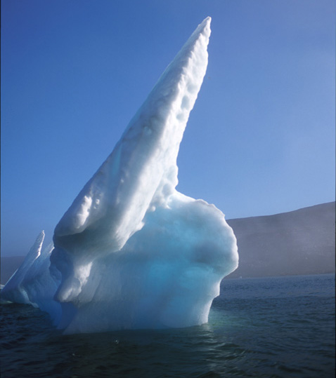
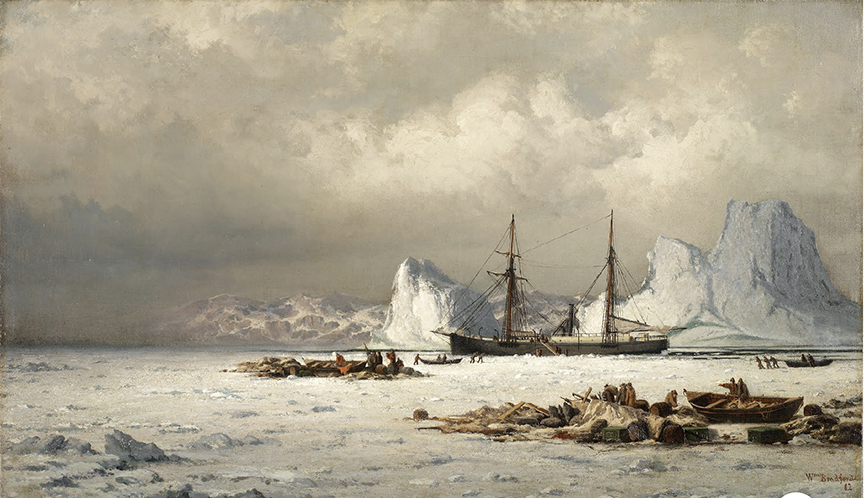
For Arctic residents and a few polar addicts, icebergs are familiar. I've skied, paddled, and boated past thousands of them. But most of us have just seen photos of these beautiful ice sculptures and may have only a vague idea where they come from. Here's a primer on one of nature's great art forms -- how they're made, how they differ from ice floes, and the many forms they come in.


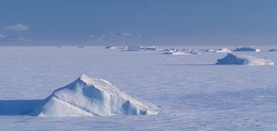
Immobile icebergs


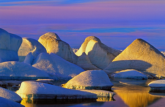
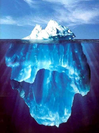
Arctic art


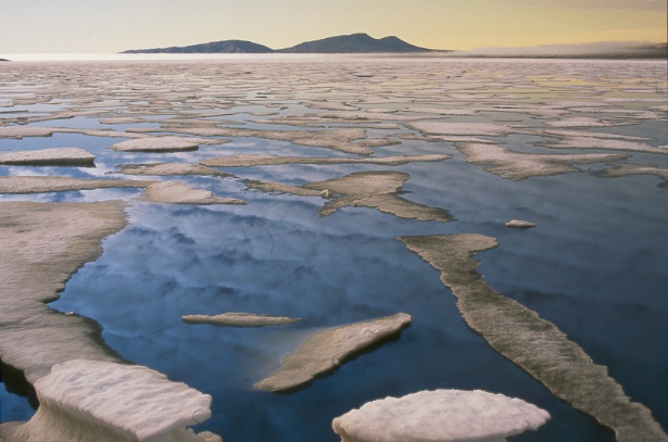
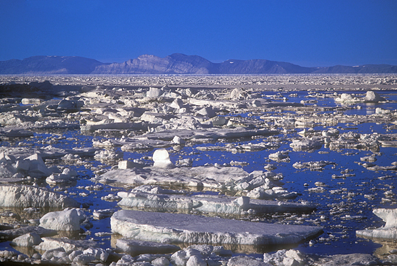
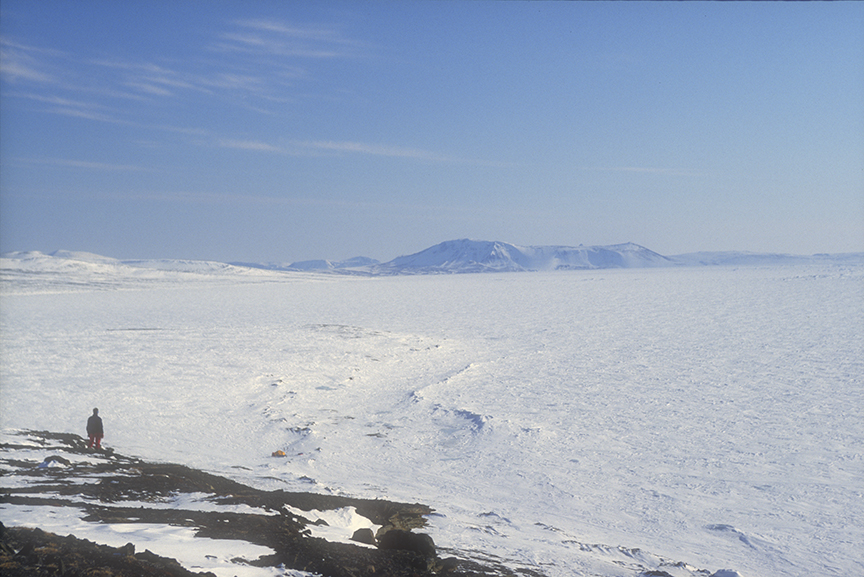
Icebergs vs ice floes


Multiyear ice: also not icebergs


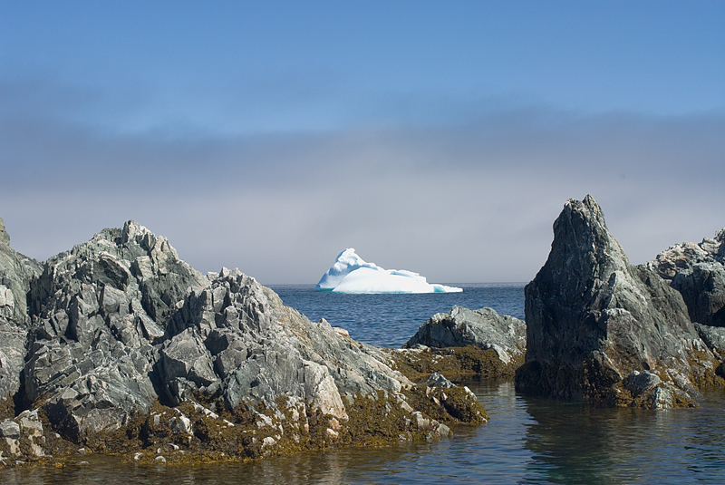
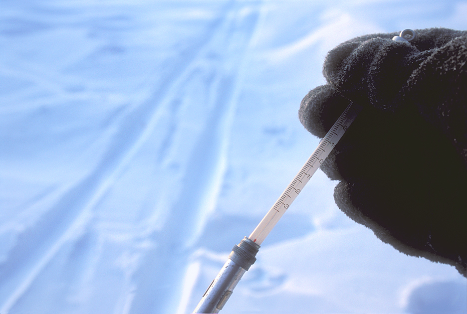
A dangerous beauty
Icebergs can be as dangerous as they are beautiful. As a rule of thumb, boaters should not approach closer than twice the distance of an iceberg's height. See video below.
The second-largest country in the world, Canada has two million lakes, 8,500 rivers, and three gigantic coastlines. Most of the 40 million Canadians live within 150km of the U.S. border. Almost everything above that is wilderness.
Some of the 20 highlights below are classics, some are hidden gems, but all are guaranteed to deliver.
Eastern Seaboard
Day Trips
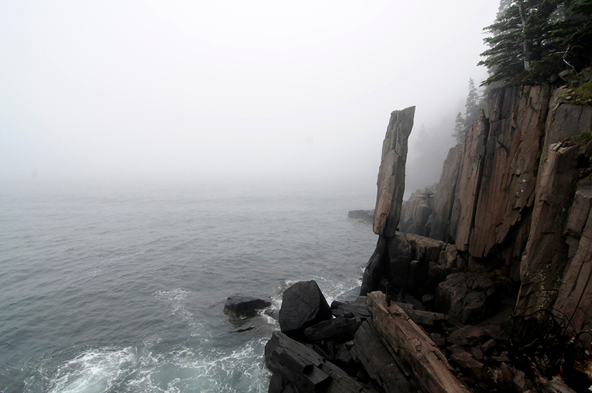
Balancing Rock
A local favorite worthy of national attention, Balancing Rock is a nine-meter-high basalt column poised above St. Mary’s Bay, Nova Scotia. Although the delicately perched rock looks as if a stiff wind would blow it over, it is not as precarious as it seems: Years ago, someone hooked a line over it and tried to topple it with a fishing boat, but thankfully failed.
Balancing Rock is located on Long Island, just a short ferry ride from Digby Neck. A 2.4km trail leads down to the photogenic pillar.
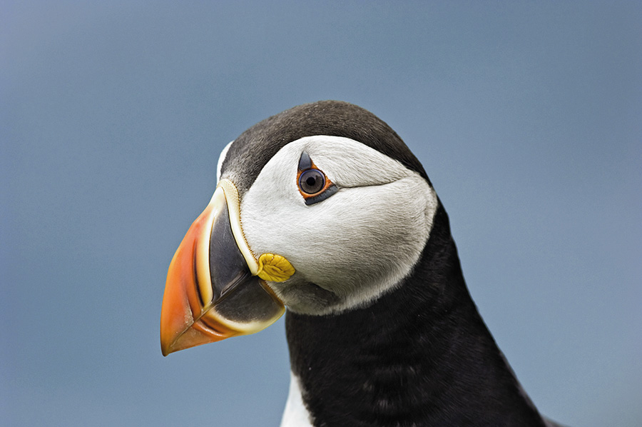
St. John’s puffins
A mere half hour south of Newfoundland’s capital, the Witless Bay Ecological Reserve holds North America’s largest colony of Atlantic puffins. A tour boat brings visitors close to the grassy island on which more than 260,000 pairs of the clown-faced birds breed. On the way to Witless Bay, don’t miss Cape Spear, the easternmost point in North America. Humpbacks and other whales often breach off the rocky point.
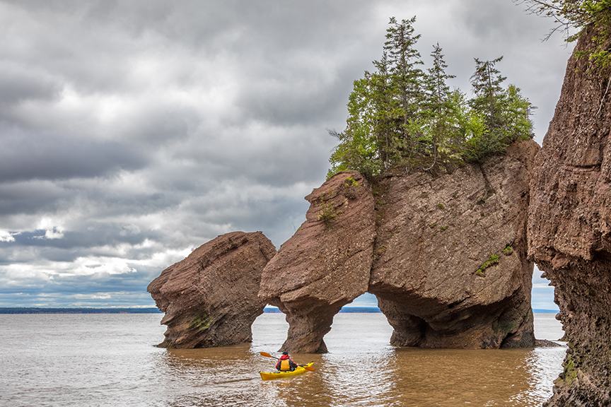
Fundy, New Brunswick tides
The world’s largest tides, as high as a four-storey building, flood the Bay of Fundy twice every day, submerging sea stacks, reversing waterfalls and seeming to cause rivers to flow upstream. Two lucky accidents make Fundy unique: As the bay constricts, it loses depth, so the tidal onrush pillows up. And the precise length of the bay, 290km, amplifies the waves even higher. It’s a trick of fluid mechanics called the Seiche effect, but it’s simpler to think of Fundy as a tuning fork pitched perfectly for high tides.
Adventure
Trans Labrador Highway
Adventurous motorists can now drive 1,200km through the wildest corner of eastern Canada, past ink-black lakes, lobsticks of black spruce and little else for hundreds of kilometers at a stretch.
The road begins in Wabush-Labrador City and deadends around Blanc Sablon, Quebec. From there, you must either retrace your way or take a ferry to Newfoundland.
The road is now fully paved, but so isolated that free satellite phones are available to borrow in case of breakdowns. (No cell coverage, except in some towns.) Sightings of black bears and wolves are common. One of Canada’s great wilderness roads. Note that Labrador accommodations tend to be basic motel/B&B.
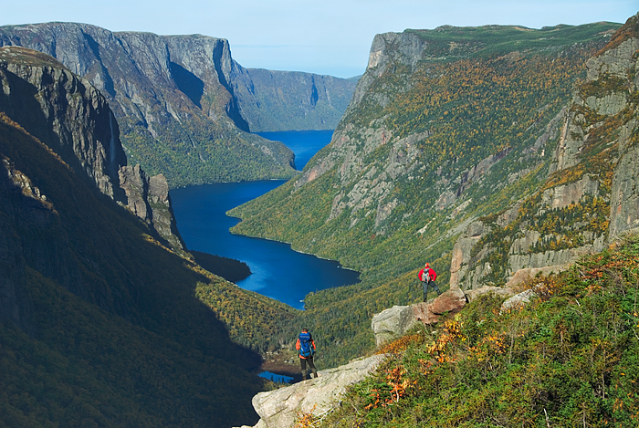
Gros Morne National Park
As a drive, a day hike, or even a serious multi-day backpack, Gros Morne on the island of Newfoundland symbolizes eastern adventure at its best. The tangerine-colored tablelands are one of the only places to see the Earth’s mantle (usually 30km or more underground). The granite sugarloaf of Gros Morne Mountain makes a great all-day outing for strong hikers, while the Long Range Traverse is the Maritimes' premier backpacking trip. The three- to four-day trek begins with a boat ride to the end of Western Brook Pond, then a steep climb to one of the most iconic views in the country. And that’s just the beginning.
Gaspé
The Gaspé peninsula’s Route 132 follows the widening St. Lawrence River as far as famous Percé Rock. This arched monolith marks the final exclamation point of the ancient Appalachian Mountains, but it doesn’t signal the end of a Gaspé experience. You can head into the mountains themselves for an exquisite study in contrast -- great hiking during the day, luxury digs at night. ChicChocs Mountain Lodge lies in the heart of a nature reserve, at the end of a private road. Think fine dining, an outdoor hot tub, larch floors, custom birch furniture. Wall-to-wall windows look out onto two local giants, Mont Matawees and Mont Albert. Lucky hikers or skiers may glimpse Canada’s southernmost caribou near the open summits.
Culture
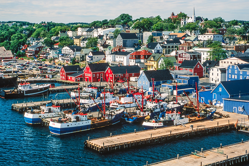
Lunenburg
Stroll past one of the Ferrari-red waterfront buildings or watch as a craftsman works on the latest incarnation of the famous Bluenose schooner, and you’ll understand why Lunenburg is one of only two urban UNESCO World Heritage Sites in Canada. (The other is Old Quebec.) Take in the Germanic architecture, or sample a more potent taste experience at a local distillery.
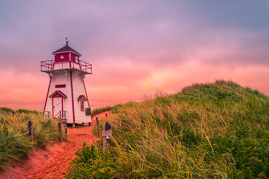
Covehead Harbour Lighthouse
Prince Edward Island has 54 lighthouses, but one of the prettiest is at Covehead Bay in PEI National Park. The red-and-white structure sits by itself on a grassy bench overlooking a swimming beach, surrounded by flowers, sand dunes, and rippling grass. On a dark day, the scene captures the windswept raw spirit of the Maritimes; in sunshine, it’s a postcard.
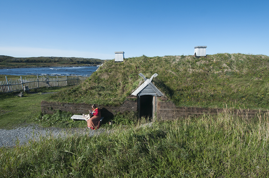
L’Anse aux Meadows
Driving distances in Newfoundland are farther than they appear, but if you have enough time on the island, don’t miss the World Heritage Site at L’Anse aux Meadows, at the tip of the Northern Peninsula, on the wind-lashed shores of the Atlantic Ocean. Here in 1960, researchers Helge and Anna Instad found the remains of the first (and still only) Norse village in North America.
Today, the original grassy mounds and depressions remain as subtle as most archaeological sites, but the exquisitely re-created longhouses, inhabited in summer by gregarious park employees chosen for their wild hair and dressed as Vikings, show how those explorers lived 1,000 years ago

Quebec’s Flavor Road
The Charlevoix region east of Quebec City already has great hiking, biking, and whale-watching, but it’s also become a gastronomical destination. The Flavor Road, concentrated around Baie-Saint-Paul, features artisanal cheeses, chocolates, breads, fine meats, and microbreweries to help wash those dainties down. Check www.routedesaveurs.com for details.
Westward Ho
Day Trips
Icefields Parkway
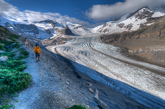
One of the world’s most beautiful roads, Alberta’s Icefields Parkway covers 230 mountainous kilometers from Jasper to the Trans Canada Highway just west of Lake Louise. En route, it scales three major passes. You could spend an entire summer traveling the Icefields Parkway and getting out whenever you saw a promising hike or photograph.
The extraordinary width of this well-maintained road allows you to park just about anywhere. You can whiz along at 90kph or Sunday drive at 40kph, carefully scanning the ditches for grizzly bears on early June mornings when dandelions draw the bears out.
The road boasts too many classic stops to list, but the not-to-be-missed category includes iconic Peyto Lake and the Columbia Icefields; and two great day hikes, Parker Ridge and Cavell Meadows, during the wildflower peak in mid-July.
Kananaskis Country
When locals in Calgary or Canmore want a day in the mountains, many head into Kananaskis Country. Its trails outshine many of those in the nearby national parks: they’re quieter, and since K-Country hikes start higher, they reach treeline sooner. More time in the alpine.
To get there, take Highway 20 south just east of where the Trans Canada Highway enters the Rockies, or opt for the rougher Smith-Dorien Highway up through the mountains behind Canmore. It eventually joins Highway 20, which soon climbs to 2,206m Highwood Pass –- the highest point in Canada along a paved highway. K-Country guidebooks list dozens of worthwhile hikes, but the drive to Highwood Pass itself is a gem.
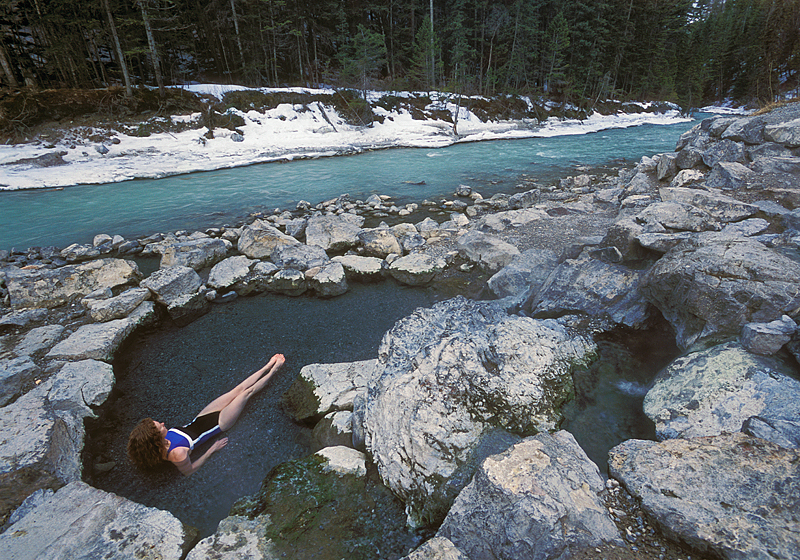
Lussier Hot Spring
Canada has about 110 hot springs, all of them in the west or northwest. Some are closed to the public, others are giant paved swimming pools with piped-in spring water. But many are just natural depressions in a wild setting, known more to locals than to tourists. Lussier Hot Spring, in Whiteswan Lake Provincial Park north of Cranbrook in southeastern B.C., has that primitive feel.
The temperature of the pools ranges in summer from 34°C to 43°C. Go early in the morning, especially on weekends, if you want the place to yourself: It may not be on the international radar, but it’s popular with local families.
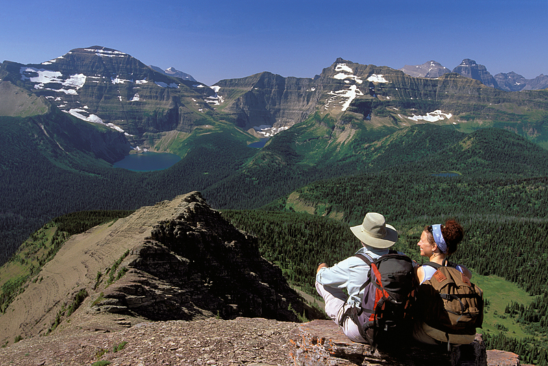
Waterton Lakes National Park
Grand old hotels abound in the Rockies but few are more spectacularly placed than the regal Prince of Wales Hotel. The 100-year-old castle sits on a giant berm overlooking Upper Waterton Lake. Here, you can enjoy high tea while peering out of giant floor-to-ceiling windows
If tea and crumpets sound too sedentary, tackle instead one of Canada’s best day hikes, the 20km Carthew-Alderson Trail. The one-way route requires parking in Waterton Village and taking a morning shuttle to the trailhead at Cameron Lake. A steady climb leads to eagle views at Carthew Summit, with glimpses into mountainous Montana. Then it’s down, down, down, past a chain of terraced ponds. In the distance, past a notch in the mountains, the hazy prairies begin, without the usual foothills.
Adventure
Dempster Highway
By the third week of August, a couple of hard frosts have killed the bugs, cranked up the vivid reds and yellows of the mosses, and transformed the Dempster Highway into one of the great scenic drives of the world. This 747km gravel highway begins just outside Dawson, in the Yukon, and finishes at Inuvik, on the Mackenzie River delta. You can drive the entire Dempster in a long day, but most people take two days, stopping at the lone station of Eagle Plains.
The Dempster crosses two mountain ranges, the Ogilvies in the south and the Richardson Mountains in the north. Day hiking into both ranges from the road is easy and requires little experience, except for knowing when to turn back. The road traverses the Ogilvies for some time, while it crosses the open Richardson Mountains at just one spectacular point.
Gwaii Haanas National Park
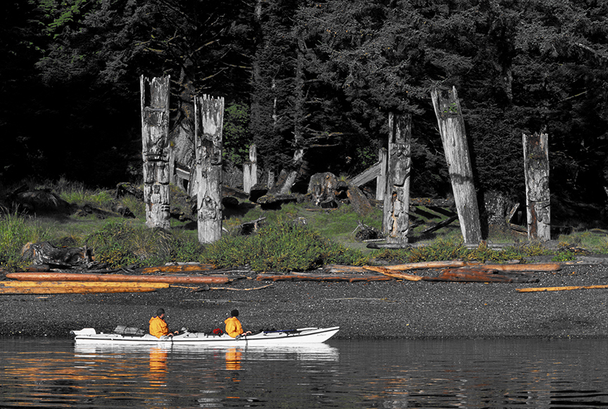
Canada’s Galapagos is also an iconic sailing and sea kayaking destination. Highlights include Burnaby Narrows, the richest intertidal area in the world. The narrow channel all but dries out at low tide, exposing thousands of colorful bat stars, sea urchins, red rock crabs, and a cornucopia of shallow-water creatures. The famous 200-year-old red cedar totems at SGang Gwaay bear witness to a time, not too long ago, when the powerful and artistic Haida ruled this part of the B.C. coast.
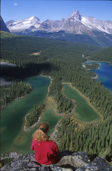
Lake O’Hara
Beloved by landscape photographers, the Lake O’Hara area in Yoho National Park had already captivated Group of Seven artists in the 1920s. The nearby Opabin Plateau remains a favorite with day hikers. To reach Lake O’Hara, take the morning shuttle (reserve your seat far in advance) from the parking lot near Field, B.C.
Although a campground and alpine hut cater to more hard-core outdoor people, many visitors either just stay the day or overnight at the swank Lake O’Hara Lodge. Prime season is the third week of September, when the larch have turned golden and the scenery with them.
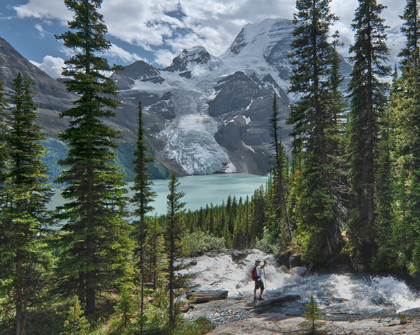
Mount Robson
The highest mountain in the Canadian Rockies rises like a singleton volcano from the surrounding landscape rather than merely as the loftiest among many. Its massive, glaciated summit is best seen from Berg Lake. Small icebergs from a glacier drift in the lake’s turquoise waters. The three- to four-day B.C. backpacking adventure (20km one way) to Berg Lake puts you before one of the grandest scenes in Canada. More than a postcard, it could be the back of a hundred-dollar bill.
Those with the energy for a long day hike while camped at Berg Lake should tackle the nine kilometers to Snowbird Pass. The pass looks down onto the gigantic Reef Icefield. It’s like suddenly being transported to Antarctica. You have no idea that the icefield is there until the last moment, when you crest the final ridge and look down onto a white infinity.
Culture
Okanagan Wine Festival
Wine tourism is big business in B.C.’s Okanagan Valley, but nothing outdraws the wine festivals. Though the valley hums year-round with the appreciative ahhs of merlots and pinots being sampled, the pièce de résistance is the fall festival, which takes place in early October. You can take courses in wine appreciation, learn how to pair wine and food or simply show up at one of the region’s 60 wineries and cart away a case of your favorite vintage. www.thewinefestivals.com
Canmore Folk Festival
A folk festival with top talent, a community feel, in a gorgeous setting: It’s hard to imagine finding all three in the same place, but that’s what happens every summer in this Rockies town on the border of Banff National Park. Old folkies share the intimate stages with rising stars on the world music scene, while greying hippies sway to the beat and music lovers of all ages gorge on great local food. The non-alcoholic festival is especially family-friendly.
As we reported yesterday, a polar bear attacked a skier in Auyuittuq National Park on Baffin Island last week. Details are scant, but the skier was evidently injured but all right. Authorities later shot the bear.
Several of our readers commented on the incident. "It amazes me how people can be so lacking in common sense," wrote someone who identified as Jennifer. "You are trespassing on the polar bear's home, yet you blame them when you're attacked... If you stay away from them in the first place, you would not be attacked. It's simple, stay out of their habitat."
"Why would anyone kill the bear??" said Andrew. "He's living in his habitat, and people are invading it. Terrible!!!"
"With polar bears now endangered and their habitat rapidly shrinking through no fault of their own, this isn't really acceptable," agreed MW.
Not the bear's fault
A similar article in Baffin Island's own Nunatsiaq News also drew several comments. Note that not all readers of this Arctic newspaper are Inuit, or even live in the north.
"This was 100 percent not the bear's fault, as it was obviously not a predatory attack," wrote Terry Sigurdson. "The bear was most likely protecting cubs or startled...Sad ending to a preventable situation."
"If you’re stupid enough to go into bear or other wildlife country to ski or whatever when you are only concerned about having fun, you deserve whatever wildlife does to you," said another.
No firearms?
Finally, two readers took issue with Parks Canada's rule, mentioned in the Nunatsiaq News story, that non-Inuit are not allowed to carry firearms in Arctic national parks.
"This is wrong in so many ways," said one. "Baffin Island is not Banff. This polar bear attack is 100% the fault of Parks Canada and their crazy rules."
"I completely agree," said another. "They should be held liable for any polar bear attacks. It’s crazy to think that in Svalbard, they don’t allow people to step into polar bear territory without a gun, and here they’re forcing hikers to expose themselves to danger by not carrying one."
There's a lot to unpack here. Let's try.
I may be the editor of ExplorersWeb, but I'm also an Arctic traveler who has had over a dozen close calls with polar bears. I've never had to kill one, but it's been close -- for both of us. So my perspective will be affected by my experiences and by the fact that I've chosen to travel the Arctic independently in the first place.
I do carry a firearm, and although I once went without one in an Arctic park where polar bears were historically rare, it was an uncomfortable gamble. Polar bears are great explorers and can show up anywhere, anytime. A tour group discovered this about 20 years ago, when a polar bear nosed around their camp on northern Ellesmere Island -- in a spot where polar bears had never been seen before.

Vulnerable vs endangered
A few small corrections of the readers' comments:
- Polar bears are not endangered, they're vulnerable -- a still-concerning but less dire classification. Some populations, such as the one in western Hudson Bay, are more affected by climate change than others. Other populations are doing well. There are more polar bears off the coast of northern Labrador than there have ever been in historic memory.
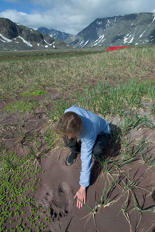
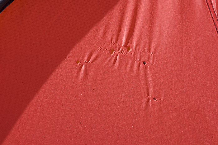
- It is certainly not obvious, especially given the paucity of details, whether the incident in Auyuittuq last week was or wasn't a predatory attack. Humans are very different from a polar bear's usual prey, which is seals. Most polar bears want nothing to do with us. They run away, or amble off in that dignified bear manner. Polar bears are, however, one of the two animals in North America that occasionally stalk people as food. (The other is the cougar.) Typically, an interested polar bear approaches slowly, trying to make up its mind about you. "Is this something that might injure me, or should I make a play for it?" Adolescent males -- cocky like human adolescents, still poor seal hunters -- are the worst offenders; almost all my incidents have been with them. However, as Russian polar bear biologist Nikita Ovsyanikov once explained to me, polar bears are among the world's most conservative animals. Ovsyanikov became famous for walking around polar bears with just a long stick and an attitude. With an confident attitude (feigned, of course), they are relatively easy to scare away with non-lethal deterrents like flares or bear spray. A warning shot sometimes works too, though not always. But while it is not possible to say anything about the incident on Baffin Island, I would not classify most of my close calls with polar bears as "predatory attacks." Mostly, they feel as if the polar bear is probing, to see if an escalation is justified.
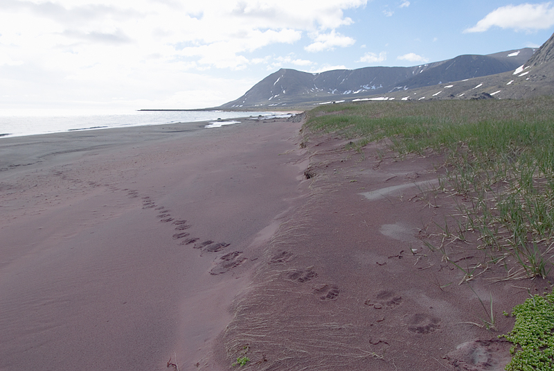
A polar bear patrolling a beach detoured to investigate a campsite in northern Labrador. Photo: Jerry Kobalenko Cubs not an issue
- Nor is it likely that the polar bear was "protecting its cubs." That's a potential issue with black bears and grizzlies surprised in the confined spaces of the southern woods. In the open Arctic, both parties tend to see each other coming, and a polar bear simply moves off.
Photo: Jerry Kobalenko - As one reader of Nunatsiaq News pointed out, authorities killed the bear not as capital punishment for the crime of injuring a person, but because such an encounter can lessen a bear's fear of people and lead to other, more deadly incidents. Down south or up north, this is pretty standard wildlife management following any animal-human clash. It's one reason why responsible outdoor people need to take pains to avoid these in the first place -- eg. by not feeding wildlife. The person may survive, but the animal is certainly doomed.
- Finally, it is a common misconception that anyone who goes out on the land in Svalbard, those polar bear-rich Arctic islands off the coast of Norway, must carry a firearm. That was never the case; it was just strongly recommended. In recent years, it's become a little more time-consuming for foreigners to acquire a firearm permit.
For 'fun'
Some have criticized the skier for being up there at all, potentially risking the life of a polar bear for "fun." The implication is that nature is great, but only without people. We inevitably gum up the works, so we should stay in our cities and leave the animals safe and unmolested in their shrinking domain. One can disagree with that, but it's impossible to argue against it, because it's essentially a religious position.
There have been a couple of cases in the Canadian Arctic where adventurers behaved badly and caused the death of a polar bear. Years ago, a Swiss man named Markus Bischoff let a bear come too close during a solo dogsledding adventure so he could get better photos. The bear may then have come too close, and Bischoff shot the bear. He was later charged.
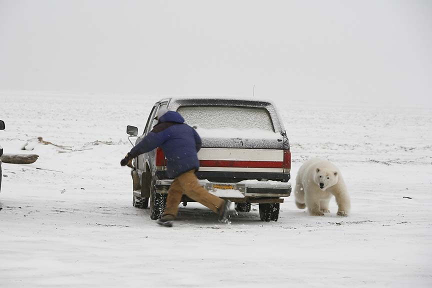
A photographer in Churchill, Manitoba, who was not paying attention, was chased around his truck by a polar bear. Another photographer filmed the close call. The man managed to take refuge in his vehicle.
Minimize risk
There are many ways to minimize the risks of a polar bear encounter that can go badly for one or both parties. However, if you travel the Arctic enough, you will eventually see polar bears, and almost certainly have to deal with a too-curious one. You can't go into polar bear country with the woo-woo attitude that Timothy Treadwell had with his grizzlies in Alaska. You have to be prepared to defend yourself -- while at the same time, recognizing what a failure shooting a polar bear would be, and to do everything possible to avoid it.

For three and a half days earlier this month, Eric Philips, 62, was in an environment that made his familiar Antarctic plateau seem almost hospitable. Sardined in a tiny capsule with three other amateur astronauts, he orbited our blue marble at 7.6km/sec. Outside, the blackness of space, with its microgravity and zero air and unseen perils of radiation and micrometeorites.
"What never gets old is Zero G," Philips told ExplorersWeb. "It's like being a child all over again."
Previously, we explained how Philips' late-career adventure came about. Two years ago, he guided a ski tour on the Norwegian Arctic Islands of Svalbard. One of his clients, Chinese-born Maltese citizen Chun Wang, was interested in talking about space travel. Not uncommon: Simple environments often appeal to polar types.
But in this case, Chun had the resources to do more than talk. He had made a fortune in bitcoin mining and wanted to buy a commercial flight on SpaceX. A few months later, he invited Philips, Rabea Rogge (a German robotics engineer and fellow skier on the tour), and cinematographer Jannicke Mikkelsen, based in Longyearbyen on Svalbard, to join him. Chun would cover expenses, in the range of $200 million.

A year of training
For a year, Philips and his three partners trained for the mission, which they dubbed Fram2 after the famous Norwegian polar ship. Most of the training took place at SpaceX's headquarters in Los Angeles. The Dragon capsule flew on its own, but they had to learn what to do in case something went wrong. Among the things Philips had to practice as the designated medical officer was inserting a catheter in case of an emergency. However, all went well.
"In the end, we used maybe one percent of our training," said Philips.

On March 31, after several days in quarantine near Cape Canaveral in Florida to avoid catching a bug before the flight, it was time to launch.
Centrifuge training had given some practice with the tremendous G-forces of a rocket tearing itself free of Earth's gravity, but even that didn't compare to the 4.6 Gs of the real thing. It was enough for them to feel their organs compress, said Philips. But it didn't last long.

Kármán line
They cleared what is called the Kármán line, 100km above the Earth, at which point they were officially astronauts. Soon, the main engine expended its propellant and fell away. Almost immediately, the second engine kicked in, propelling them to an altitude of 200km. From there, onboard thrusters lifted the capsule into orbit, some 450km above the Earth.
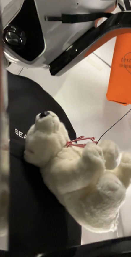
The first sign of microgravity Philips noticed was the loose ends of his restraint straps beginning to float. At the same time, a mascot that astronauts call the Zero G Indicator began to float around the 2.5-meter-wide capsule. For this mission, their Zero G Indicator was a stuffed polar bear wearing an emperor penguin necklace.
This wasn't just a nod to Philips' background or where they met. This was the first time a spacecraft was planned to orbit the Earth via the Poles. From the 1957 launch of Sputnik until now, they have all been, from our perspective, "horizontal" orbits, not vertical.
"Because of our polar orbit, the Earth rotated beneath us, so we passed over every part of it," Philips told ExplorersWeb. "We're told this is a blue planet, because of all the oceans. But we were often over whiteness."
Pure silence
In orbit, Philips noticed how quiet it was. Freed from gravity and without the friction of the atmosphere to slow them, they flew (or rather, fell) around the Earth with only occasional need for the booster to kick in, to keep their orbit from deteriorating. When it fired, sparks appeared outside the window, like a little fireworks show.
SpaceX broadcast the launch on its website, and a program called Zero Six Zero showed the Earth in more or less real time, with a simulated version of the capsule moving above it. In almost no time, they made their first pass over the South Pole. Forty-five minutes later, they flew over the North Pole. Orbiting at 27,000kph, it took them just three-quarters of an hour to travel halfway around the world.
Every day, they went through multiple phases of darkness and light. They made 55 orbits in all. Always, Philips delighted in "the sheer joy of microgravity."

"What surprised me is how quickly I adapted," said Philips. "I'm sensitive to motion sickness, and I was likely to get terribly space sick. But the first day was great. On the second day, we all experienced a little nausea but quickly recovered."
A warm capsule
The interior temperature of the capsule ranged from 24˚ to 28˚C -- warm for polar travelers. When they needed to sleep, they climbed into thin sleeping bags and just floated around above their seats, bumping lightly into one another as they slept.
During the day, drifting around in the cramped space, they were often "a tangle of limbs," said Philips. His experience of being stuck in a small tent in Antarctic blizzards for three or four days at a time came in handy here.
Besides the otherworldly sensation of microgravity, everyone's favorite experience was their time in the Plexiglas cupola — a clear dome atop the capsule, just big enough for one person at a time. From there, they could take turns looking at both the blackness of space and our amazing planet below. The Plexiglas was solid enough to repel radiation and any micrometeorites that might strike it. During launch and splashdown, a protective nosecone covers the cupola.

Philips knew from his prior reading that, contrary to the old myth, the Great Wall of China is not visible from space -- and sure enough, it isn't. But he did notice at night how bright China was with artificial lights, "far more than any other country."
What he saw
He also identified other areas, both natural and manmade: their launch site at Cape Canaveral, the mountains of Alaska, and Svalbard, the archipelago that brought them all together. Philips also made out parts of Queen Maud Land in Antarctica, although at this time of year, darkness or twilight had settled over much of the White Continent.
The crew had 11 large satchels tucked away in a cargo section, containing food and water for five days. "It was like packing a sled," recalled Philips. The Australian was even able to enjoy coffee in space, although it probably didn't measure up to the typically excellent coffee in his own country.
For unclear reasons, SpaceX has always been shy about its onboard toilet facilities, and Philips and the others had to sign an NDA not to discuss it. Some space aficionados have pieced together information about it, however. Philips admitted that on such a short-duration flight, astronauts are administered enemas before launch to simplify the first couple of days.
700 astronauts
Since Yuri Gagarin, there have been almost 700 astronauts, but counting these four, there have only been 11 tourists who have gone beyond suborbital experiences and into outer space. As part of their program, they performed some 22 experiments, including taking the first X-ray in space and growing mushrooms. Cinematographer Jannicke Mikkelsen filmed. But largely, it was about soaking up an out-of-the-world experience.
When it came time to descend, they packed everything away -- including the Zero G Indicator -- put on their suits and strapped themselves in. "It was like being in a sailboat and preparing for an impending storm," said Philips. "You do your best to prevent items from flying around."
Their reentry also generated 4.6 Gs, but their brief time in weightlessness made it feel even more forceful than during the launch. Meanwhile, the temperature outside the capsule rose to 2,000˚C from friction in the atmosphere.
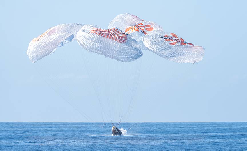
Two drogue parachutes deployed at about 5,500m in altitude while Dragon was moving at approximately 560kph. At about 1,800m, the drogues pulled out the four main parachutes. The Dragon hit the water at about 25kph off Oceanside, California -- the Dragon's first Pacific splashdown.
A ship waiting five kilometers away then came and winched the capsule on board. All the astronauts were able to exit the hatch by themselves, although one was a little shaky walking to the medical bay.

'A hurricane raged in my mind'
But after such an intense, at times ecstatic experience -- microgravity, seeing our planet for the first time from space -- there was bound to be a hangover. Philips recalled:
At the medical bay, my body went into shutdown. It was difficult to communicate with people in any meaningful way. A hurricane was raging in my mind. I could answer questions like, 'Are you in pain?' with no problem, but for two or three days, I couldn't describe the experience.
Days later, they still experienced floating sensations. Once at breakfast, Philips imagined he could float over to the buffet to get his food.
While their extraterrestrial experience made some past astronauts a little "spacey" in their afterlife on Earth, Philips isn't concerned.
"I'll remain the staunch skeptic I've always been," he says.

In less than a week, Norway's Borge Ousland and France's Vincent Colliard will fly north to Resolute Bay, Canada. There, they'll take a $72,000 charter flight (ouch) to the north end of Ellesmere Island. For the next six or seven weeks, they'll ski south over the interior ice caps to King Edward Point, the southernmost tip of Ellesmere.
It's part of Ice Legacy, their multi-year project to cross the world's 20 largest ice caps. And except for the solo crossing of Antarctica that Ousland, now 62, did back in 1996-97, it will be their longest. The 1,100km will tick off three ice caps on their list -- the Grant, the Agassiz, and the Prince of Wales. They will then have only four left to do.
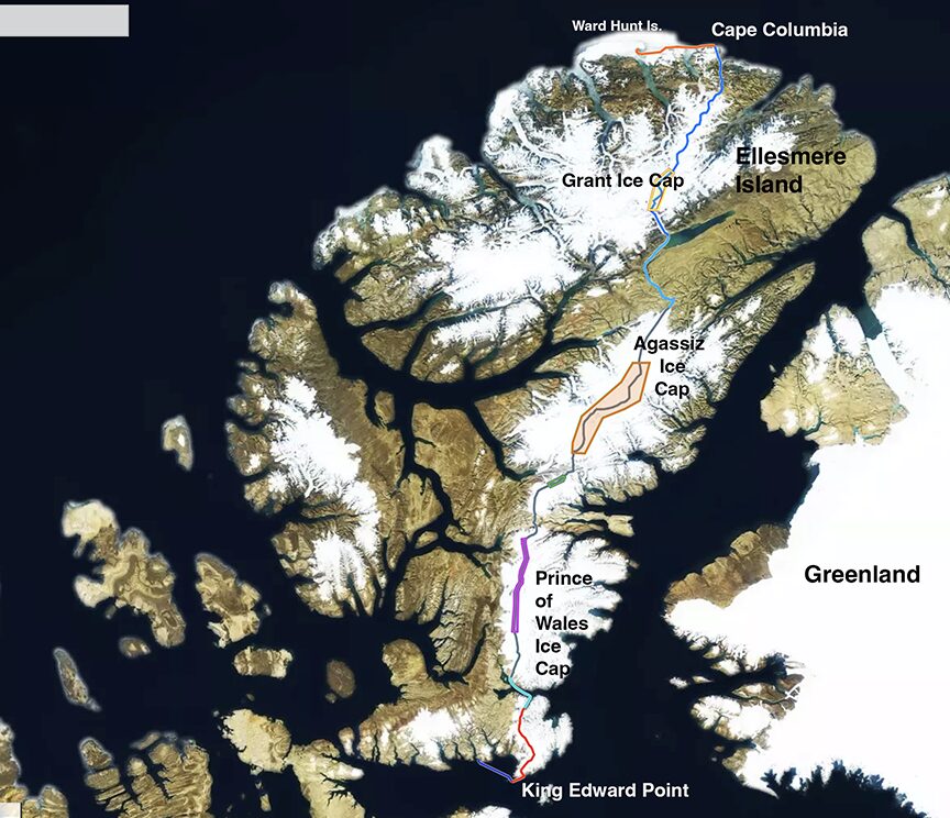
As a side project, the pair will attempt to make the first unsupported north-south crossing of Ellesmere, the tenth-largest island in the world. Two other parties did a vertical traverse of Ellesmere -- John Dunn and three partners in 1990 and Bernard Voyer and team in 1992. Jon Turk and Erik Boomer skied/kayaked completely around the island in 2011, passing both the northernmost and southernmost points. But all three of these previous expeditions had multiple resupplies. Ousland and Colliard will carry everything with them.
Cape Columbia
The Twin Otter aircraft will land them at Ward Hunt Island, a small satellite off Ellesmere's north coast. They will ski east to Cape Columbia, Ellesmere's (and North America's) northernmost point. At 83˚07', it is just 760km from the North Pole. The veteran Ousland has touched Ward Hunt Island before, when he and Erling Kagge became the first to ski unsupported to the North Pole from Ellesmere in 1990.
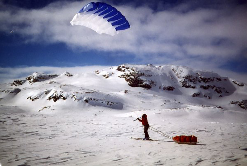
Their route includes brief land sections between the three ice caps, but they will travel mostly on glacier ice. They'll largely ski under their own power but will carry Beringer ski sails to take occasional advantage of the light Ellesmere winds. Ski sails are more rudimentary than kites and do not need beefy mountaineering skis and boots, like kiting does. You can ski sail and manhaul with the same gear, Ousland told ExplorersWeb.
Veteran duo
Ousland's many accomplishments in both the Arctic and Antarctic put him at the very head of modern polar travelers. Besides his unsupported North Pole trek with Kagge, he skied solo and unsupported to the North Pole from Russia in 1994 and became the first person to cross Antarctica (also ski sailing) in 1996-7. In 2006, he and Mike Horn skied to the North Pole in winter, and in 2019, he and Horn crossed much of the frozen Arctic Ocean, also in the dark. The two were dropped off and picked up by ship.
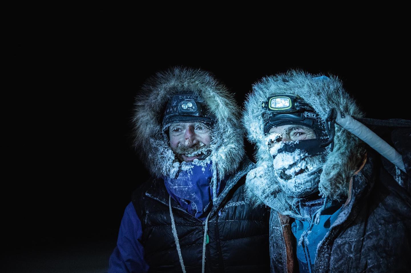
Although Colliard, 39, can't match such an unprecedented polar resumé, the pair have completed 10 of the 13 ice caps together. (Ousland did Antarctica, Greenland, and Iceland on his own.) Last year, Colliard broke Christian Eide's long-standing speed record from Hercules Inlet to the South Pole, covering 1,130km in 22 days, 6 hours, and 8 minutes.
North to Nowhere is the funniest film about North Pole expeditions that you'll ever see. Polar explorers have always taken themselves very seriously, but luckily Montreal filmmaker Josh Freed took a bemused perspective on the crazy cast of characters vying to reach the top of the world one spring back in the late 1980s.
At that time, modern North Pole expeditions were in their heyday. In 1986, American Will Steger and his party made the first unsupported dogsled trip to the Pole. That same year, Jean-Louis Etienne of France skied the 760km alone. (Earlier, in 1978, the great Japanese adventurer Naomi Uemura had reached it alone using dogs.)
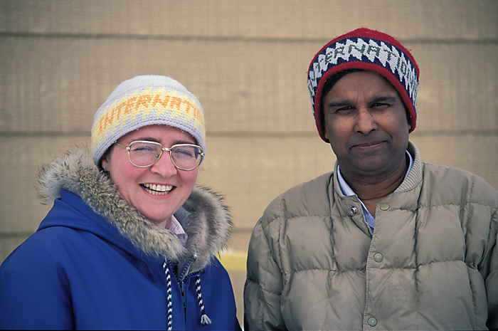
These were serious adventurers, but every year, several less prepared travelers also showed up in Resolute Bay, Canada, touting their great plans to reach the North Pole in various creative ways. Resolute's beloved outfitter, Bezal Jesudason -- featured in the film -- provided logistics and tried to advise them as best he could. Jesudason, who improbably came to the High Arctic from India, used to joke that he himself was planning an expedition to the North Pole by elephant.
Do you need oxygen?
In this pre-internet era, information about the North Pole was not as easy to come by as it is today. Some would-be polar explorers would phone to ask if they needed to bring oxygen "that high up." One British man imagined that he could walk about 80km a day over the broken surface of the Arctic Ocean and was going to show up with just 10 days' food to reach the North Pole. "He was even so generous as to bring two days' extra for bad weather," Jesudason later told me. Luckily, the outfitter managed to dissuade the man from coming.
Scandinavians were usually competent, but one spring, two older Swedes showed up in Resolute with no idea how to use a camp stove. Unable to melt water during two brief shakedown trips near Resolute, the experience so humbled them that they went home without even beginning their expedition. Others spent thousands of dollars to charter an aircraft to the north end of Ellesmere Island to begin but quickly realized they were in over their heads. Typically, they called for a pickup a few days later, citing back injuries as a convenient excuse for quitting.

An influencer ahead of his time
The expeditions profiled in North to Nowhere belong to this zanier crowd. Two French pilots/gourmet chefs set out to fly their canary-colored ultralight plane to the North Pole. There was Shinji Kazama, a Japanese Yamaha salesman who -- heavily supported by Inuit with dogsleds -- took his motorcycle to the Pole. Then there was Dick Smith, the founder of Australian Geographic magazine, who sought to go there in his helicopter. The extroverted Smith was a visionary who anticipated the selfie/Instagram generation and walked around holding a lightweight movie camera pointed at himself and breathlessly narrating the adventure that was about to unfold.
With admirable restraint, North to Nowhere documents the goings-on during this brief Golden Age of what people in Resolute used to call the Silly Season.
Climate change, politics, and difficulties chartering aircraft have ended the hijinx for the time being. The last full-length North Pole expedition was in 2014.
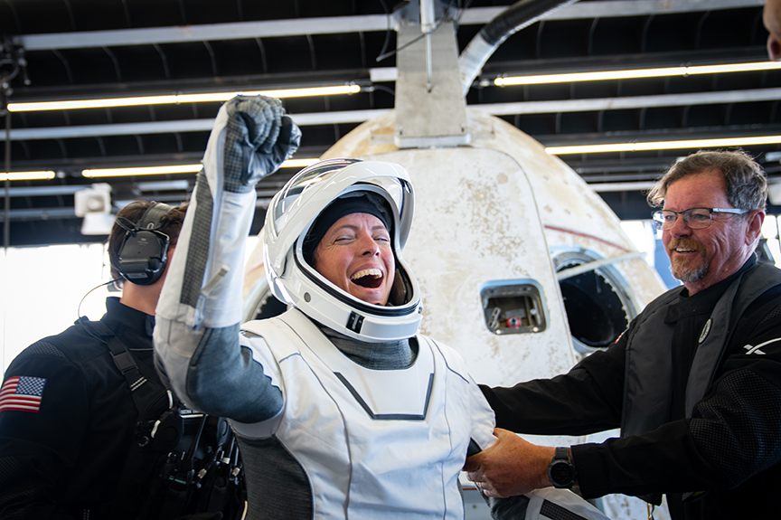
The official "10, 9, 8..." countdown has not quite begun, but later this morning, at 9:46 am ET, Australian polar guide Eric Philips and his three fellow astronauts will blast off into space from Florida's Cape Canaveral aboard SpaceX's Falcon 9 rocket. For the next three-and-a-half days, they will orbit the Earth via the North and South Poles -- an orbital track never done before.
For the 62-year-old Philips, this late-career opportunity came out of the blue. He was guiding a ski tour on Svalbard. One of the participants, Chun Wang, was interested in talking about space. It turned out that Wang had made a fortune in the early years of bitcoin mining and wanted to buy a commercial space flight from SpaceX. He invited Philips to join him, along with two other Svalbard acquaintances, Rabea Rogge and Jannicke Mikkelsen. The cost of the flight is undisclosed, but previous private missions on SpaceX cost around $200 million.
The four of them have been training at SpaceX headquarters near Los Angeles for the past several months. Now, weather permitting, the big day has arrived.
Among their many new experiences, Philips, who wears glasses, has learned to wear contacts for the first time so his glasses won't fog up inside the space suit. However, sometimes myopia temporarily clears up in zero gravity, so he might find that he no longer needs them -- at least for those three-and-a-half days.
You can watch the launch live and follow what they call the Fram2 mission, named after the famous Norwegian polar ship, here.

Today, a naval warship rescued 44-year-old ocean rower Aurimas Mockus off the coast of Australia.
The Lithuanian rower was within a week of completing his 12,000km row across the Pacific from San Diego to Brisbane when Tropical Cyclone Alfred hit him. It generated winds up to 100kph and waves up to seven meters high. He set off a distress signal on Friday when he was about 740km from his endpoint.
Australian search-and-rescue authorities sent out planes, which eventually located the exhausted rower. A naval ship, HMAS Choules, was dispatched to pick him up.

Mockus had been rowing on his own for almost five months.
Only three rowers -- Peter Bird, John Beede, and Michelle Lee -- have completed the Pacific crossing.
In 1905, during Roald Amundsen's first transit of the Northwest Passage, two of his men set out from Gjoa Haven to explore the unmapped east coast of Victoria Island. They reached halfway up before turning back due to the lateness of the season. Now 38-year-old Anders Brenna of Oslo will set out early this spring to manhaul 1,100km alone from Gjoa Haven all the way up past the explorers' farthest north and around to Glenelg Bay on northern Victoria Island.

Brenna, a father of two, seems in some ways a typical Norwegian, with a practical attitude and a background in winter activity that could make up for his modest arctic experience. His parents worked in search and rescue, and he spent a lot of time outdoors as a kid. He did cross-country skiing and biathlon in his teens and trained in winter with the Norwegian military. (He's still employed as a civilian with the military.)
Then in 2022, the arctic bug bit him. He did a 120km solo ski trip in Hardangervidda, a subarctic national park between Bergen and Oslo. There, he traveled 120km in a week between Finse and Haukeliseter. He had already traveled Hardangervidda with the military, but Brenna wanted to do this on his own, to begin to develop the routines of independent arctic travel.

A big step up
As a next step, last April, he joined a 20-day expedition in the Canadian Arctic run by Borge Ousland's adventure company. He and half a dozen others skied 400km from Cambridge Bay to Gjoa Haven in Nunavut. When he was at the airport in Gjoa Haven to fly home, he realized he wanted to return. He's been planning this current endeavor ever since.
Brenna acknowledges this will be much harder than Hardangervidda and a guided three-week tour. He'll have to navigate, ski an average of 20km a day with a much heavier sled, deal with severe cold, camp totally on his own, and watch out for polar bears.
"This is another league from what I've done before," Brenna admits, "but that's not a reason not to do it."
Along with expedition logistics, he has been researching the 1905 expedition of Godfred Hansen, Amundsen's second in command, and engineer Peder Ristvedt. The pair dogsledded from Gjoa Haven across the sea ice and up the east coast of Victoria Island. Although Amundsen became the first to sail through the Northwest Passage, this was the only new land his expedition explored.
Cairn search
Hansen and Ristvedt turned back at what they called Cape Crown Prince Olaf, where they built a cairn that Brenna hopes to rediscover. There, they sighted a distant cape to the north that they called Cape Nansen, after the great Norwegian explorer. Brenna is particularly looking forward to standing at Cape Crown Prince Olaf and figuring out exactly what they meant by Cape Nansen.
He will then continue north along Victoria Island, covering the unexplored area they missed, which explorer Vilhjalmur Stefansson first mapped on his Canadian Arctic Expedition 10 years later.
Interestingly, in 1919-20, Godfred Hansen made another journey on behalf of Amundsen. Amundsen hoped to succeed where Nansen's original Fram expedition had failed and sail his ship, now the Maud, across the Arctic Ocean via the North Pole. To this end, he had Hansen travel the north coast of Ellesmere Island and leave supply depots for him. Hansen's distinctive russet-colored tins stenciled with "Beauvais Kjobenhavn" (the Danish company providing the food) still lie in obscure caches on northern Ellesmere Island. Amundsen's expedition never came off.

A cold start
Since Brenna can't afford a helicopter pickup from his endpoint on northern Victoria Island, he is leaving early -- in mid-March, the coldest time of year -- so that an Inuit man can snowmobile overland from Cambridge Bay to pick him up while there is still enough snow coverage. Brenna estimates that the journey will take between 50 and 60 days.
"I'm not going in March to make things worse for myself," says Brenna.
Indeed, he believes in trying to make these journeys as comfortable as possible.
"It's easier to stay outside a long time if you're comfortable," he says. "It's also about developing routines to conserve energy."
Brenna admits he's a bit "old school" and will post the occasional entry on his website during the expedition, but don't expect a daily Instagram update.
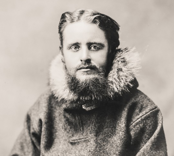
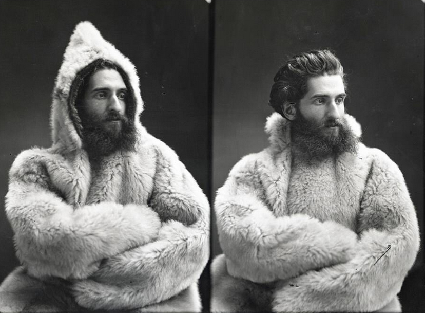
So far, the three High Arctic deaths we've covered in this series have all been the certain result of foul play. Charles Francis Hall's death is more mysterious. It may have been a murder whose motive combined expedition friction and a love triangle. Or maybe not.
Hall's background as an arctic explorer was unusual. He grew up in New Hampshire with little education, became an apprentice blacksmith in his teens before moving to Cincinnati. Here, he somehow became a businessman and newspaper publisher. He only became interested in the Arctic in his late 30s, drawn in like many others by the mystery of what happened to John Franklin and his crew.
In 1860, at the age of 39, Hall went north for the first time as a passenger on a whaling ship. Although they didn't reach the area where Franklin disappeared, Hall turned the voyage into an exploration. They showed that "Frobisher Strait" on southern Baffin Island was really just a bay and brought back some artifacts from Frobisher's expedition.
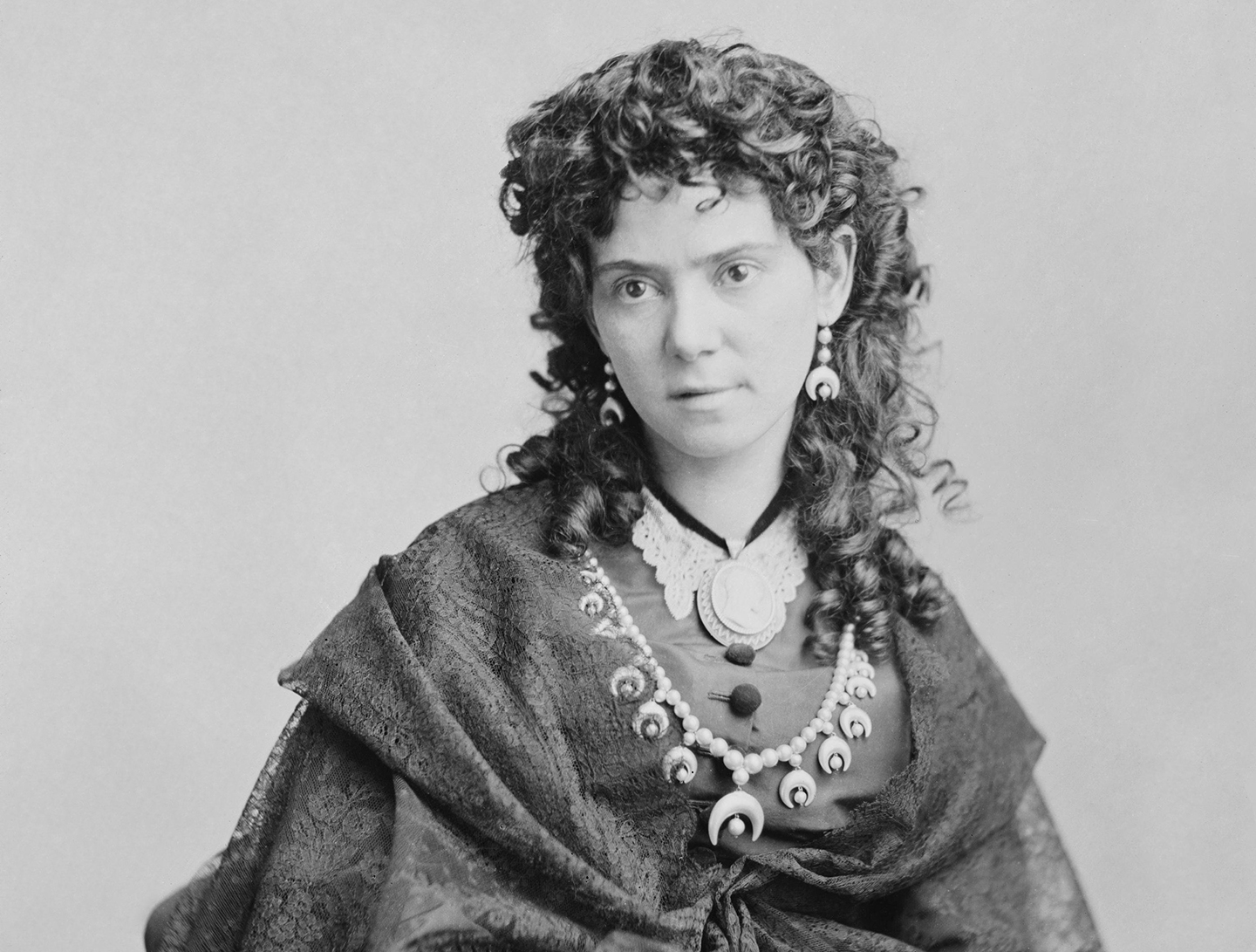
A remarkable couple
He also met a remarkable Inuit couple who spoke English, Ipirvik and Taqulittuq. Historically known as Joe and Hannah, they became prominent guides for several white explorers and accompanied Hall on all three of his expeditions.
His second expedition began in 1864. This time, he reached King William Island in the central High Arctic, where Franklin's ships became trapped in the ice and where so many men perished. He made no great discoveries but did find some bones and other remains from the lost expedition.
Hall stayed north for several years, learning from Inuit like Ipirvik and Taqulittuq how to live in the Arctic. Unlike many famous explorers who went north merely as a career move, Hall genuinely loved the place.
“The Arctic is my home," he wrote once. "I love it dearly; its storms, its winds, its glaciers, its icebergs; and when I am there among them, it seems as if I were in an earthly heaven or a heavenly earth.”
Hall's attraction to the Arctic and curiosity to learn made him an excellent independent traveler. He was also undoubtedly a good self-promoter. He came out of nowhere, and through interest, vigor, and self-marketing, turned himself into one of the foremost American arctic explorers of his time.
Not a leader
But as a leader of men, he was poor at commanding loyalty. In 1868, still on that second expedition, he shot and killed a crew member under questionable circumstances. Hall later claimed the man was attempting mutiny, but other whalers on the ship said the murder was more frivolous. Nevertheless, Hall was never prosecuted.
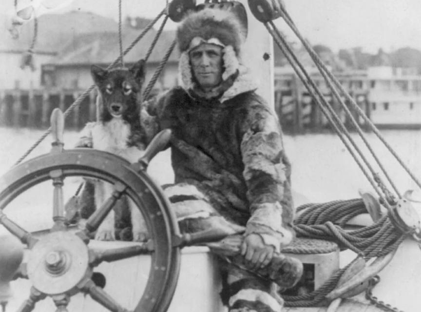
On his return to the United States, the former blacksmith's apprentice found himself in lofty circles. U.S. President Ulysses Grant and members of Congress secured for Hall a $50,000 grant -- about $1.3 million in today's dollars -- to lead an expedition to the North Pole. In 1871, Hall, an old whaling captain named Sidney Budington, who also captained the whaler on Hall's first expedition, and many others set out for North West Greenland aboard a ship called the Polaris.
The expedition featured even more drama and conflict than usual. Hall was the leader but was not the ship's captain. Some of the crew -- particularly a troublesome German contingent -- resented his authority. Factions on the ship made the atmosphere tense.
Nevertheless, it was a good ice year -- one of several in the last quarter of the 19th century -- and the Polaris forged north between Canada and Greenland as far north as 82˚11', the highest latitude a ship had ever reached. There, pack ice forced them to retreat about 50km to 81˚37' on the Greenland side. They found refuge for the winter in a sheltered nook called Thank God Harbor.
A mysterious death
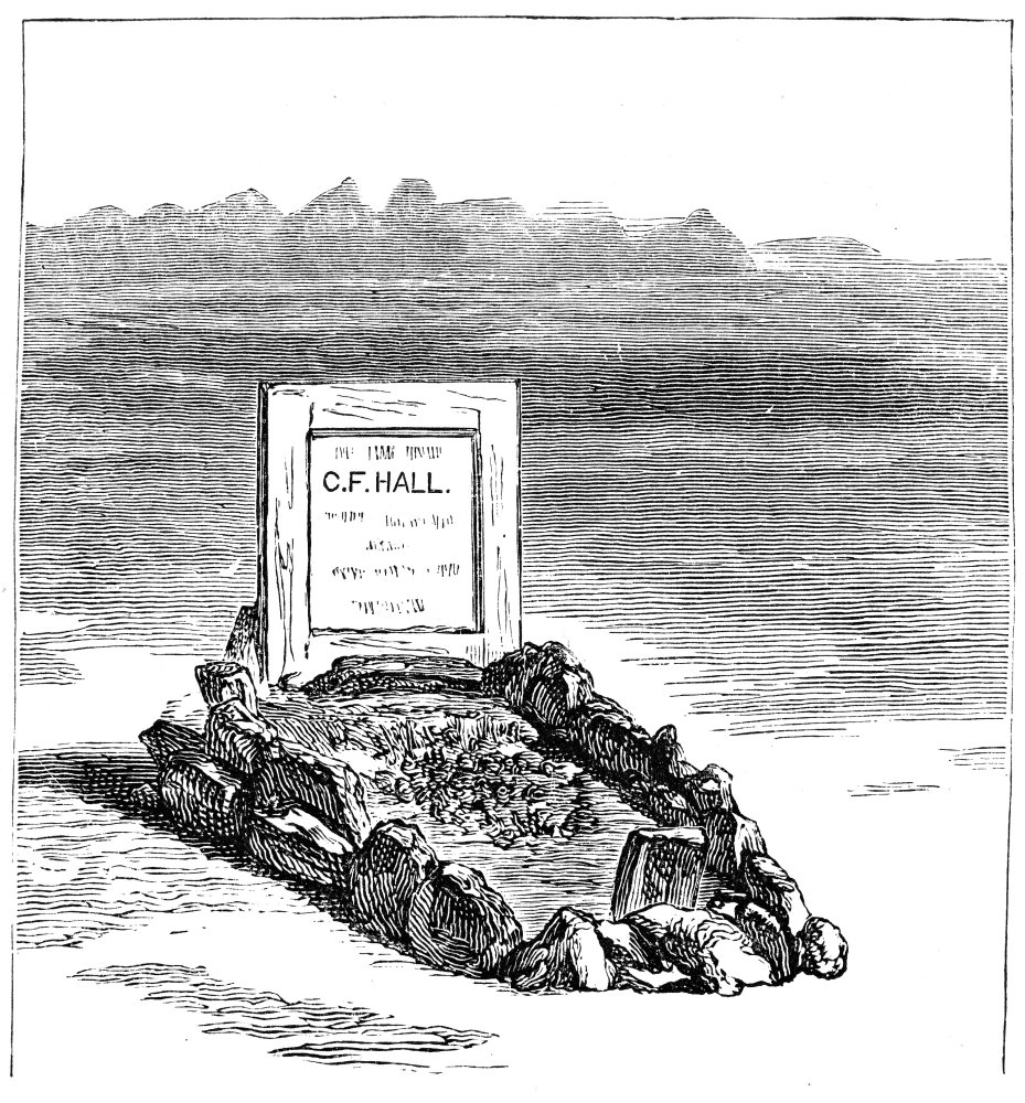
In October -- by which time the sun had already set for the winter at that latitude -- Hall dogsledded north for two weeks on a brief exploratory mission toward the North Pole. When he returned, he became violently ill after drinking a cup of coffee. The ship's doctor, Emil Bessels, diagnosed apoplexy -- a stroke.
Bessels and Hall had quarreled in the past. Confined to his cabin, Hall accused the doctor of trying to poison him. Hall had also fallen out with his old whaling captain pal, Budington. Nevertheless, the vomiting and delirium abated, and Hall seemed to be improving. But then on November 8, he died. They buried him in the tundra in Thank God Harbor.
The drama was far from over for the crew of the Polaris. The following summer, Budington managed to sail the damaged vessel south about 300km to near Etah, a temporary hunting community that later served as the base for several white explorers.
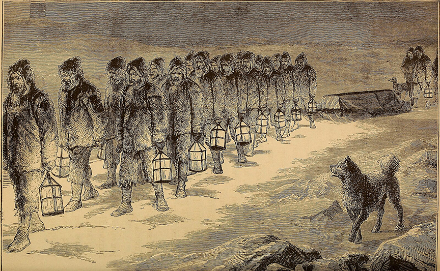
Morale continued low. Then the ship was caught in the pack ice and was in danger of being crushed. There was a call to abandon ship, and 19 of the crew took refuge on the ice, along with some supplies that had been hastily thrown overboard. At that point, the damaged ship unexpectedly broke free of the pack and drifted off, leaving the 19 behind. We wrote about their ordeal, perhaps the most miraculous survival in arctic exploration, in a previous article.
The Polaris itself was eventually shipwrecked near shore, but the crew remaining on board survived the winter. Then, the following summer, they sailed their small boats south, where a whaling ship picked them up.
Detective work
But what had happened to Charles Francis Hall? The mystery persisted until 1968, when writer Chauncey Loomis went to Thank God Harbor and exhumed Hall's body. The dry cold had preserved it for over a century. They took samples of his bones, fingernails, and hair, then reburied the body. Back south, they analyzed the samples and discovered that Hall had died not from a stroke but from large amounts of arsenic consumed during the last weeks of his life.
Arsenic was a component of the ship's medical kit, as it featured in many quack medicines of the day. Suspicion fell on the doctor, Emil Bessels. "If Hall was murdered, Emil Bessels is the prime suspect," Loomis later concluded in his fascinating book Weird and Tragic Shores.
However, Hall also had his own medical kit and might have accidentally self-administered the arsenic through some patent medicine.
We'll never know whether Hall was murdered or died unwittingly by his own hand. But in recent years, arctic scholar Russell Potter found an intriguing connection between Hall and Bessels that may have given the German doctor a motive other than personal dislike.
Vinnie Ream
Before sailing on the Polaris, Hall and Bessels both made the acquaintance of a beautiful young sculptor named Vinnie Ream. Ream "was attracted by [Hall's] bear-like quality...but Bessels became instantly infatuated with her," according to a source cited by Potter. Both Hall and Bessels later wrote to Reams. Could this have spurred the doctor to rid himself of a romantic rival?
Other articles in this series:
Murder Near the North Pole, Part I: The Death of Ross Marvin
Murder Near the North Pole, Part II: Death on an Ice Island
Murder Near the North Pole, Part III: The Death of Peeawahto
In 1914, explorer Fitzhugh Green shot and killed his Inuit guide Peeawahto. Green was a member of the Crocker Land Expedition, which set out to find a mysterious island that Robert Peary allegedly spotted off northwestern Ellesmere in 1906.
The expedition leader, Donald MacMillan, had been north once before, as one of Peary’s assistants. An ambitious man, MacMillan hoped that the discovery of Crocker Land would make his reputation. The expedition was affiliated with the American Museum of Natural History (AMNH).
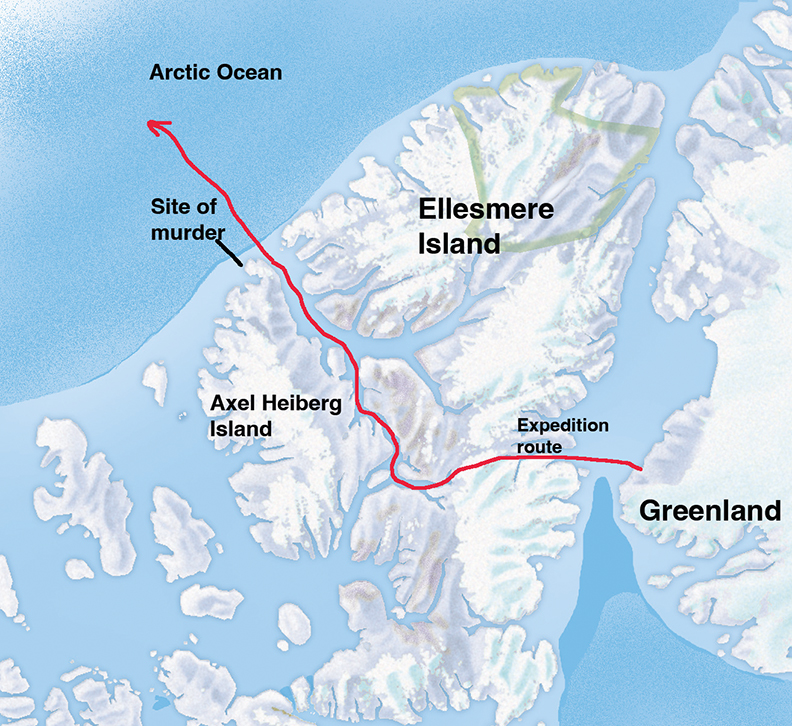
The published account of the murder had always seemed strange to me. In a storm on northern Axel Heiberg, Fitzhugh Green’s dogs are buried and die. Peeawahto won’t slow down for Green, who is on foot. Green, convinced that he is being abandoned, shoots Peeawahto in the back, appropriates his team, and rejoins the others. MacMillan’s laconic summary of the event: “Green, inexperienced in the handling of Eskimos…had felt it necessary to shoot his companion.”
Searching for clues
Except for one brief detour, I’ve covered the Crocker Land Expedition’s entire route from Greenland to the northern tip of Axel Heiberg. In particular, to better understand the murder, a partner and I manhauled 700km to the scene of the crime near Cape Thomas Hubbard. I then visited Bowdoin College in Maine and the AMNH in New York to look over the expedition journals.
Bowdoin College has Green’s journal. Between the tattered brown covers and pemmican stains, fear lurks between the grandly penciled lines. Green would write some forty books in his life, all bad. But the journal is, at its key moments, unaffected. It shows a man overwhelmed with panic.
MacMillan’s journal is in New York.
“Not our favorite topic,” commented the librarian when I asked for Crocker Land material. “Wasn’t someone killed on that expedition under museum auspices?”
At the AMNH, I found the photo of Peeawahto that heads this story.
The expedition begins
The Crocker Land Expedition overwintered in Greenland. The following February, with an army of 19 men, 15 sleds, and 165 dogs to lay depots, MacMillan set out for northern Axel Heiberg and the Arctic Ocean.
As they advanced and laid down supplies, all of MacMillan's party turned back to Greenland except MacMillan, Green, and two Inuit, Etukashu and Peeawahto. Peeawahto (Piugaattoq, in modern orthography) had previously served with Frederick Cook, as well as with Peary and Knud Rasmussen, who described him as “a comrade who was ready to make personal sacrifices in order to help and support his companions.”
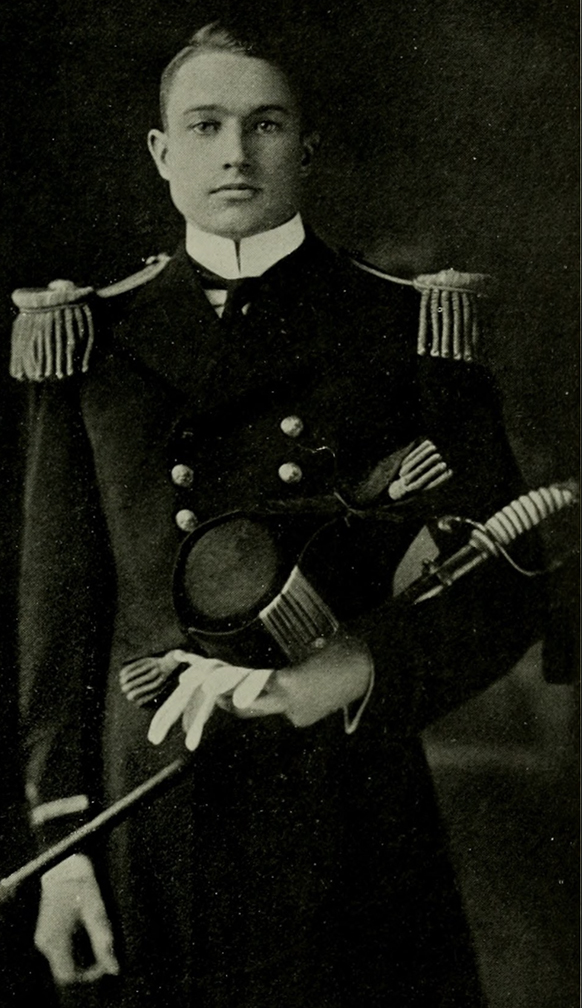
Fitzhugh Green, a 25-year-old naval ensign, came from good old stock. His great-great-grandfather had been a large Virginia landowner in the 1600s. As a young man, he was talkative and ingratiating, with a tendency to fawn over his betters –- and he expected those whom he considered his inferiors to defer to him. This made his dealings with the Inuit condescending at best.
Cringeworthy
MacMillan and Green fancied themselves the dauntless explorers leading the happy-go-lucky, childlike Eskimo. Green's posturing, in particular, was cringeworthy:
“Their life was a sublimely simple fight for food and clothing,” he wrote later. “Mine was a cruel struggle of such labyrinthine intricacy that only the genius could be rich and none be truly contented save the shrewdest philosophers.”
Spring weather is usually good on Ellesmere, but 1914 featured one gale after another. Fighting the north wind was exhausting. Once Green fell asleep chewing his supper. They couldn’t spot wildlife in the blowing snow. Dogs died, and men went hungry. Worried entries about the worn-out dogs recur daily in Green’s journal.
A good spot for a murder
Eureka and Nansen Sounds separate Ellesmere Island from Axel Heiberg Island. As you move up Eureka Sound into Nansen Sound, the high ice cap of Axel Heiberg tapers to low hills. Western storms can now deposit their snow on upper Nansen Sound. The very names reflect the moister climate. Ellesmere’s Black Mountains yield to the White Peninsula.
The mood changes, too. Even in a gale, Eureka Sound feels protected. But as Nansen Sound opens into the Arctic Ocean, there is nothing but exposure. It is the wildest place I've ever seen, a good spot for a murder.
On April 14, MacMillan, Green, Etukashu, and Peeawahto struck northwest across the Arctic Ocean toward the hypothetical Crocker Land. Incredibly, they managed to travel 250 kilometers offshore, but of course, they found nothing. There was nothing to find.
“I could plainly see that the Eskimos were discouraged,” MacMillan confided in his journal. “Peeawahto did not like the looks of so much open water so late in the year.”
As they headed back to land empty-handed, Green and MacMillan walked to lighten their load. Etukashu and Peeawahto rode, as Greenlanders always did.
They hurried to reach Cape Thomas Hubbard at the northern tip of Axel Heiberg, averaging 50km a day. They touched land on April 28.
A fateful assignment
Since Crocker Land didn’t exist, MacMillan must have felt pressured to bring back as many extras as possible. So although the dogs were exhausted and Peeawahto and Etukashu were impatient to get home, he proposed a four-day split-up.
He and Etukashu would cross Nansen Sound to revisit old Ellesmere cairns. Meanwhile, Green and Peeawahto would close the ring on Axel Heiberg by covering its last unexplored section, the fifty kilometers between its northern tip and latitude 80°55' on the west coast. Here they were to retrieve Sverdrup’s 1900 cairn message. “All the adventurous blood in my veins boiled up at the prospect,” wrote Green later.
Sverdrup’s end cairn has eluded the handful who have looked for it over the last hundred years. It is a great prize. In it, Sverdrup left a note declaring sovereignty over the arctic islands for the King of Norway.
On one manhauling trip, my partner and I spent a day and a half scouring the shoreline for it. We focused on the north side of a small, unnamed bay, which most closely matched Sverdrup’s description. Sverdrup and one of his men spent hours building the cairn. It must have been sizeable, but in an open landscape where nothing manmade escapes notice, we found no trace.
A blizzard hits
Green and Peeawahto never got that far. Shortly after separating from MacMillan on April 29, 13km southwest of Cape Thomas Hubbard, the worst storm of the year hit. It became so violent that Peeawahto quickly built a small igloo near shore, and they sheltered inside it.
For the next two days, Green’s journal becomes almost raving. Their stove doesn’t work. Drifting snow keeps plugging their igloo’s ventilation hole. “I was about done for,” he writes. “It was black as night in the hole.”
The next day, April 30, the wind drops a little, and they go outside and dig out Peeawahto’s sled. Green claims that his own sled and dog team are “under 15 to 18 feet of hard-packed snow,” so he gives them up for lost. “We cannot move yet, although to stay here is almost suicidal,” he says.
Retreating to the igloo, they try to melt snow for tea but have more trouble with the stove. “P. refused to make a hole in the roof…The fumes made us both sick, and I vomited several times.”
Conflict and murder
In the early hours of May 1, the wind briefly dies, and Green wants to continue to Sverdrup’s cairn. Peeawahto refuses, saying that MacMillan had instructed them to proceed just one day down the coast.
“I told him that I was master now until we got back to Mac,” says Green, although the argument becomes academic when the storm rises again, and they have to retreat to the igloo.
A little later, they begin their retreat with the one dog team. Green walks to keep his feet warm, but he cannot keep up with Peeawahto, who rides the sled. The storm picks up yet again. A panicking Green orders Peeawahto to slow down. To emphasize his point, he takes the rifle off the sled. But a few minutes later, Peeawahto begins to pull away again.
I fired once in the air, but he kept on. Then I fired twice, knocking him off his komatik. The dogs stopped. I ran up and found the man unconscious. I lashed him onto the komatik…
I must have wandered about for six or eight hours trying to find a familiar landmark. Finally I recognized a rock on the shore and headed for the igloo…
I finally got the snow cleared out somewhat [and took] P. in first. When I tried to do something for him, I found that he was dead.
The situation is an unhappy one. Here I am in a howling blizzard with a dead Eskimo, a strange team, and a few soaking or frozen garments…
Heroic posturing
Green’s later accounts fill in some details that his journal omits. The murder weapon was Peeawahto’s .22 Savage. At the first shot, Peeawahto slumped against the sled’s upstanders. “As the dogs did not stop, I thought that possibly he might still be alive so I shot again, splitting his head open so that his brains fell out.”
With a macabre presence of mind, Green removed Peeawahto’s kamiks –- his own footwear was falling to pieces. They didn’t fit. Green couldn’t stand the dead man’s eyes staring at him in the igloo, so he dragged the corpse outside and left it behind an ice block.
He continues his heroic posturing: “I kept wanting to say, ‘Peeawahto, you lucky dog, it’s all over for you. For me, it’s hundreds of miles of hell, with all the pain and misery of hell, and not one degree of its heat!’ But I wouldn’t let myself say it. I was afraid of being afraid.”
Green retreated the next day toward Cape Thomas Hubbard with Peeawahto’s team. The storm had also forced MacMillan to abort his journey, so he and Etukashu were camped nearby. “Mac, this is what is left of your southern division,” announced an exhausted Green when he pulled up on May 4, driving Peeawahto’s team.
“Good God, Green, is Peeawahto dead?” asked MacMillan.
Scared for his life
Green sketched out the story. Etukashu knew some English and overheard their conversation, but scared for his own life perhaps, he appeared to accept their explanation that Peeawahto had died in an avalanche.
“Etukushu took the news of his friend’s death very complacently,” wrote Green, “and was pleased with Peeawahto’s kamiks, which I brought.”
The wind continued to roar over Eureka Sound on their homeward march. On May 20, they reached their cache on eastern Ellesmere, just 50km across the frozen sound from Greenland.
“What a wonderful day,” wrote Green, “all surprises!…We found the box of supplies: sweet chocolate, marmalade, canned pears and peaches, hash, and a can of corn. My, we were happy!”
Back in Greenland, they continued to maintain that Peeawahto had died during the storm. Thanks to Etukashu, the villagers knew better but said nothing. At least one member of the Crocker Land Expedition was disgusted.
“[Green] did not consider it murder,” wrote their doctor, Harrison Hunt. “Peeawahto was just a savage…I would have to live with and care for a man who had killed my friend…I found my anger hard to control.”
MacMillan unsympathetic
Even MacMillan was unsympathetic. “[Green’s] assertion that if he had permitted the Eskimo to escape with the sledge, dogs and food, he would have starved, is not a sufficient reason for killing one of the best Eskimos I have ever known.”
After his return to America, Green continued to show the total lack of shame that was his greatest asset. In a 103-page article for a naval publication, he prefaced the murder with paragraph after paragraph of poetic babble: “Every sense has its pleasurable side. Sight loves beauty. Hearing revels in music. For touch there is sensuous softness and smoothness…”
His description of the shooting itself is no less surreal. “He that had loomed hostile and a deceit between me and safety lay now crumpled and inert in the unheeding snow…I had baffled misfortune. The feeling sent red gladness to my anemic humor…The present was perfect, ecstatic… I laughed, not fiendishly, but because I was glad…”
Aftermath
Green never went back to the Arctic after 1917, but his four years in the White North allowed him to affect an explorer’s persona for the rest of his life. He lectured widely on his experiences. Many of his books and articles play up those arctic years. He wrote of “my friend Etukashu” and how “I lived with the natives for almost four years, so I know how wonderful they are.” At the same time, casual references to “darkies” and “small brown people” continued to make their way into his godawful prose.
Always a talented sycophant, Green was aide to an admiral, to the president of the Naval War College, and to book publisher George Putnam, for whom Green wrote a gushing biography of Robert Peary. He followed with a biography of yet another arctic faker and establishment hero, Richard Byrd.
The incident does not seem to have harmed Green personally or professionally. He died in glory and honor, and his jottings and family photographs are now preserved at Georgetown University in Washington, D.C.
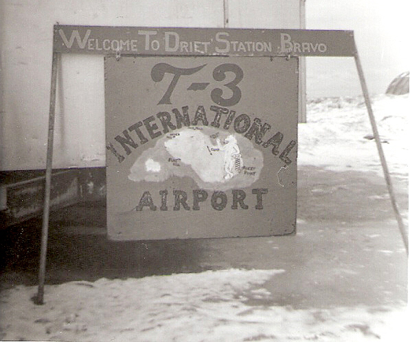
In 1970, the world’s northernmost murder took place on the drifting ice island T-3, 350km northwest of Ellesmere Island, on the Arctic Ocean.
Ice islands were big, flat pans of ice that broke off from the 3,000-year-old ice shelves that until recently, clung to parts of northern Ellesmere. They've almost all disappeared now -- broken away, melted -- but they used to be important platforms for research. Unlike sea ice, these giant platforms lasted for a couple of decades. They were so big you could land large supply planes on them.
The first one was discovered in 1946 off Alaska by a U.S. spy plane. It was classified top-secret because of its value as a base. They all came from Ellesmere Island but they could drift thousands of kilometers. Eventually, they broke up.
Since 1952, researchers under the U.S. Air Force had occupied T-3 -- sometimes called Fletcher's Ice Island after the pilot who discovered it -- almost continuously. At first, it was 52km across and 60m thick, but by the time of the murder, it had shrunk to 11km long, 6.5km wide and 30m thick.
Researchers lived in trailers and communicated with the outside world via high-frequency radio. Planes could not land on the uneven, watery summer ice, and T-3 was well beyond the range of helicopters, so the 19 men were on their own for months.
Hard-drinking misfits
In that era, such isolated outposts drew a lot of hard-drinking misfits. “Porky” Leavitt was one of them. He had already attacked three people in the camp in his quest for alcohol.
On July 16, 1970, Mario Escamilla heard that Porky had just gone into his trailer and stolen some homemade raisin wine. The doors to individual trailers did not lock on the ice island. Escamilla had been attacked by Porky before, so he brought along one of the camp rifles for protection.
He found Porky next door with the station manager, Bennie Lightsy, drinking raisin wine spiked with pure ethanol. Escamilla told Porky to stay away from his wine and went back to his trailer.
Presently, he heard footsteps. Thinking it was Porky and fearing for his safety, he picked up the gun and flipped the safety off. Bennie Lightsy entered, so thoroughly drunk that his blood alcohol was later gauged to be around .26 -- at least 12 drinks for an average-sized man.
The two argued about the wine. Escamilla ordered Lightsy to get out of his trailer and continued to brandish the rifle as the argument heated up. The gun went off accidentally, wounding Lightsy fatally. He died soon afterward.
Murder in legal limbo
Legally, T-3 was an awkward spot for a homicide. An ice island was neither land nor ship. It did not belong to anyone. T-3 originated in Canada, but it was a U.S. station manned by Americans. Although maintained by the Air Force, its civilian personnel were not subject to military law.
Ice islands simply did not exist in international law. Lightsy’s death had occurred in one of those rare jurisdictional gaps where serious crimes might go untried. Murder in Legal Limbo, declared the headline in Time magazine.
Ultimately, Escamilla was tried as if it had taken place on the high seas. In 1971, he was found not guilty of second-degree murder but guilty of involuntary manslaughter. He was sentenced to three years, but his appeal turned up enough procedural flaws to win a new trial. In the retrial, Escamilla was acquitted.
The ice island itself melted away in 1984.
In 1909, a young American, Ross Marvin, was helping Robert Peary on his last North Pole expedition. Marvin did not survive. He supposedly fell through a crack in the sea ice and drowned. Years later, it came to light that his death was no accident.
While part of the joy of expeditions is the deep bond that can form between partners, the chemistry doesn't always go well. Arctic exploration, in particular, can be so stressful that several murders and near-murders have occurred. Henry Hudson and his son were set adrift in a lifeboat by a mutinous crew and never seen again. Elisha Kent Kane almost killed one of his troublesome men by bashing his skull with a belaying pin. Charles Francis Hall was likely poisoned with arsenic by his ship's doctor. On an American expedition in 1914, a privileged young man named Fitzhugh Green panicked in a storm and shot his Inuit companion Peeawahto, thinking Peeawahto was abandoning him.
Erratic behavior
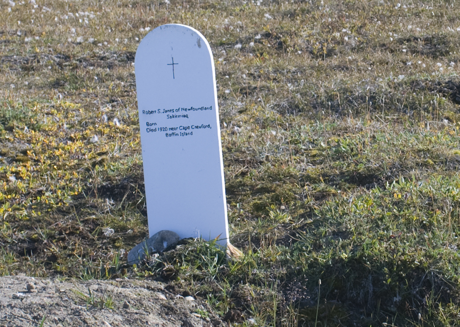
The Inuit sometimes killed people too, including white visitors. Occasionally, white men behaved so erratically that the Inuit considered them dangerous. That was the case with the overbearing trader Robert Janes on Baffin Island. His 1920 murder led to the first case in which an Inuit man was prosecuted under white man's law.
And then there was the curious case of Ross Marvin.
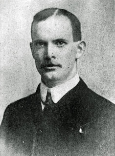
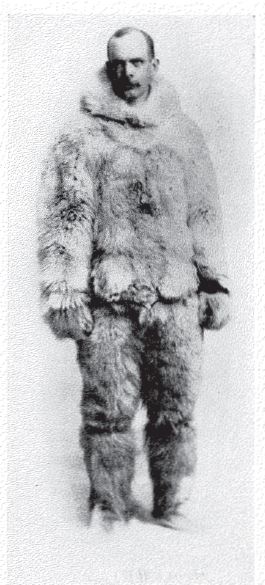
Ross Marvin.
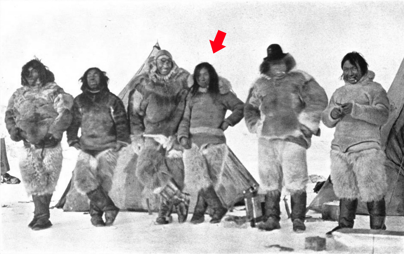
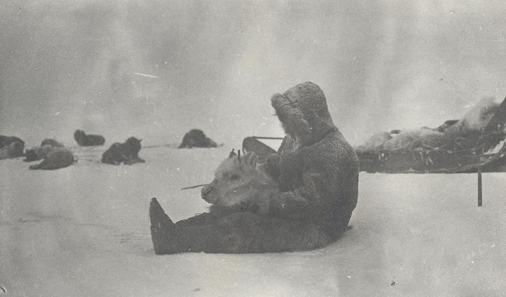
Ross Marvin was a Cornell University graduate who had accompanied Peary once before, in 1905-6. On the ship, Marvin served as the aging explorer's secretary. But in 1909, he headed a four-person team composed of himself and three Greenlanders -- Kudlooktoo (Qilluttooq in modern orthography), his cousin Inukitsoq, and Aqioq. Their job was to shuttle loads forward over the Arctic Ocean so that Peary, at the apex of this pyramidal system, could advance quickly with a light sled toward the North Pole.
Marvin's personality
Accounts of Marvin's personality -- which is relevant to this story -- differ widely. Peary's longtime manservant Matthew Henson described Marvin as "a very quiet young man, but one of great courage and strength of character...cool-headed, quiet, and just.”
Peary, a difficult man whose word must always be taken with a grain of salt, was also complimentary: “Quiet in manner, wiry in build, clear of eye...[Marvin's] good humor, his quiet directness, and his physical competence gained him at once [the Eskimos’] friendship and respect. From the very first, he was able to manage these odd people with uncommon success.”
Others, however, described Marvin as someone who never laughed, even "a pain." Inukitsoq claims Marvin threw a tantrum after Inukitsoq had followed Kudlooktoo, not Marvin, around a lead -- an open water crack in the sea ice.
“Suddenly, we became afraid of him,” Inukitsoq reported years later.

Polar controversy
Marvin accompanied his commander as far as 86˚38' north before Peary sent him back to land. It is unclear how much further Peary got, but modern historians accept that while Peary claimed he reached the Pole on April 6, he fell significantly short, and he knew it. He had sent back not only Marvin but all the white companions who could verify his navigation. He kept only Henson and two Inuit with him.
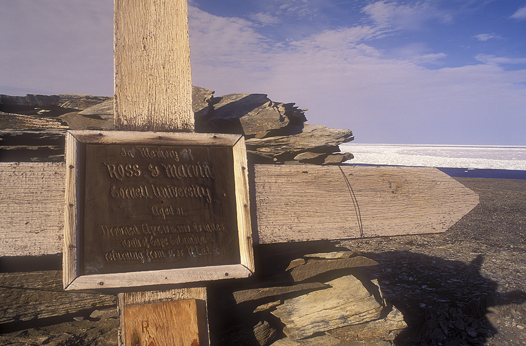
Meanwhile, Marvin and his small party struggled to return to northern Ellesmere Island. They crossed dangerous patches of thin ice; twice, Marvin fell in the water and was rescued by his companions. On the third occasion, the Inuit later reported, Marvin drowned.
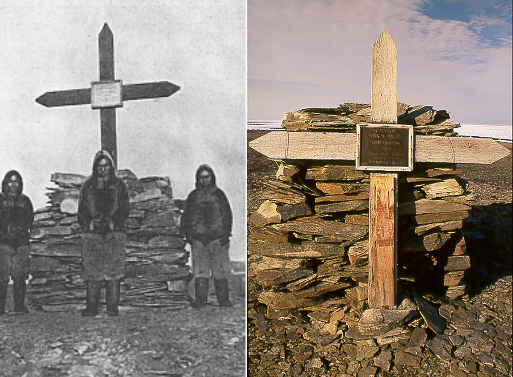
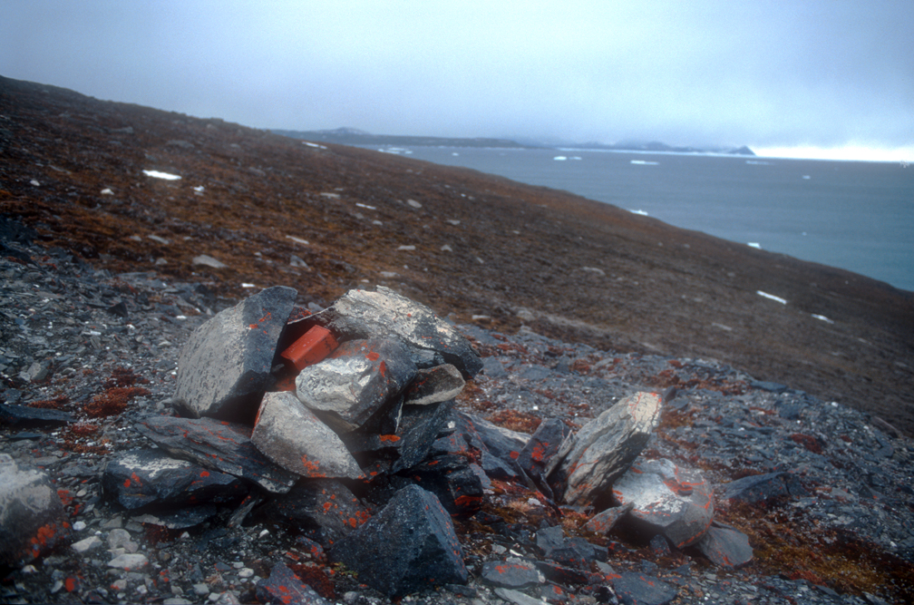
After Peary returned to the ship in late April, he learned of Marvin's death. He had a cairn built for the young man, topped by a cross with a memorial plaque. The cross and plaque toppled from the cairn but still lean against it at Cape Sheridan today. The plaque's wording, neatly done in stippled lettering with a hammer and some kind of metal point, states: “In memory of Ross G. Marvin, Cornell University, aged 31. Drowned April 10, 45 miles N of Cape Columbia, returning from 86° 38’ N. Lat.” (Marvin was actually 29.)
Aftermath
When Peary returned to civilization, he notified Marvin's parents by telegram of their son's death. In typical Peary style, he sent the telegram collect.
By then, he was embroiled in something much more important to him: He had to discredit Frederick Cook, who said he himself reached the North Pole a year earlier -- a claim now also recognized as false. And Peary had to defend his own claim. Despite several glaring holes in his account, Peary eventually won the battle. He was almost universally recognized as the "discoverer" of the North Pole until the 1960s when the doubts began to resurface.
Fourteen years after that North Pole expedition, in 1923, Kudlooktoo converted to Christianity and was baptized. He wanted to clear his conscience and confessed that the story of Marvin drowning in a lead was false.
“After my baptism, I did not want to keep this murder secret,” Kudlooktoo stated.
It turns out he had shot Marvin in the back of the head, pushed him into the water, and then concocted the drowning story with his two Inuit companions.
What happened on the ice
What happened was this: On their way back from their Farthest North, a stressed and frostbitten Marvin behaved impatiently. He forced the party to cross stretches of thin ice rather than wait for it to freeze more thickly, as the Inuit advised. When young Inukitsoq fell sick, Marvin ordered the others to abandon him.
As mentioned above, it had happened before in the Arctic that when white explorers behaved in a way that the Inuit considered a danger to themselves, execution was regarded as a rational solution. Kudlooktoo shot Marvin in order to save Inukitsoq.
In 1925, the Greenland explorer and ethnologist Knud Rasmussen heard the story of Kudlooktoo's confession and spoke to Kudlooktoo to verify the details. Rasmussen then reported it to the Danish government and brought the news to the United States.
In 1926, there was pressure to extradite Kudlooktoo to the U.S. to face charges. But Denmark then suggested that in that case, they would ask that Fitzhugh Green be extradited to Greenland to stand trial for the murder of Peeawahto in 1914.
In the end, neither man was ever charged.
A lot of contemporary adventure is long on athletics and short on imagination. Is it really exceptional any more to jumar the South Col route on Everest? Or to be the 1,401st person to climb Mount Vinson in Antarctica?
Some might argue that the great adventures have already been done, but even that is not true. The last successful North Pole expedition was 10 years ago; only one party has gone to the North Pole and back to land; no one has done a solo round trip. No one has skied entirely across Antarctica. The first kayak expedition entirely through the Northwest Passage only took place last year; no one has kayaked the ice-choked and even more difficult northern route through that Passage. Hiraide and Nakajima perished this past fall, attempting the unclimbed West Face of K2. No one has reached the North Magnetic Pole since the 1980s, before it began its tear across the Arctic Ocean toward Russia. There is still a lot out there, even for iconic goals.
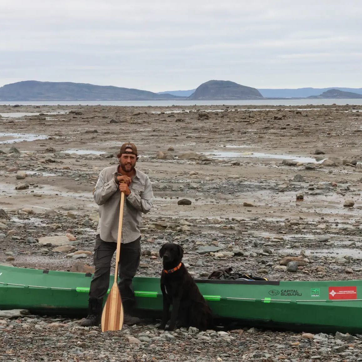
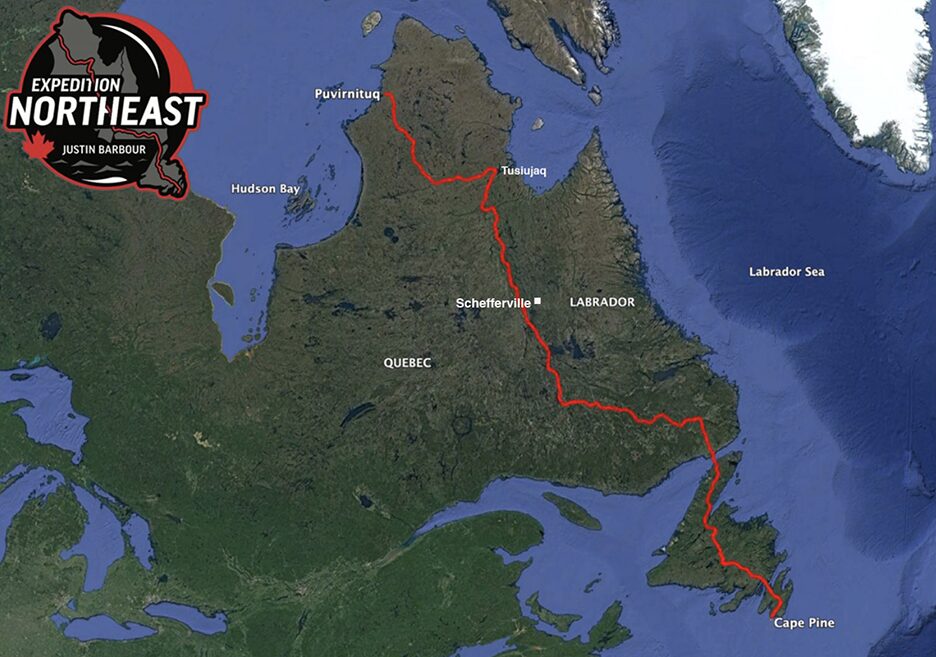
Admittedly, it's easiest to find original routes that aren't as well-known as the North Pole or K2. Canada's Justin Barbour did that this year. The former Newfoundland school teacher turned content creator spent an entire year traveling 3,800km from Puvirnituq, in northern Quebec on the shores of Hudson Bay, to Cape Pine, the southern tip of the island of Newfoundland.
Puvirnituq? Cape Pine? Not exactly iconic. Likely, no one will ever re-do this journey. It's a one-off. But give Barbour marks for that. It shows imagination to figure out your own path. It also suggests someone educating himself about the land, not just copycatting the one or two routes he's heard about.
A full year
“I want to experience a full year in the northern wilderness," Barbour told ExplorersWeb before the journey. "To experience the four seasons as the indigenous people of the area have."
Barbour first came to ExplorersWeb's attention in 2018 when he tried to trek and canoe 1,700km through the same general region from Labrador to Hudson Bay. He started late and had to abort after about 1,000km as winter set in.
"I had enough summer experience, but my winter skills in the subarctic cold weren’t there yet," he admitted.
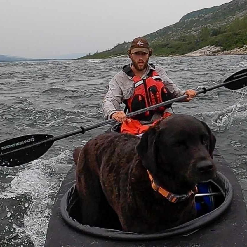
Six years later, the 36-year-old Barbour is more experienced. He started in early July of 2023 at Puvirnituq, an Inuit village with a population of about 2,000 on the shores of Hudson Bay. Thirty-eight days and 692km of downriver paddling and upriver canoe hauling with his dog Saku, he arrived at his first checkpoint, the village of Tasiujaq on James Bay.
Waiting for winter
It was mid-August, and a chill was already in the air, as the short arctic summer quickly turned to fall. Barbour continued south in his canoe, trying to make 700km to his next stop, the former mining town of Schefferville, before winter set in.
He didn't quite reach it. A helicopter pilot friend conveyed him to Schefferville. He lived for a few weeks in his heated bush tent outside of town, as he waited several weeks -- like the trappers and Innu people of the interior used to do -- for the brooks and lakes to freeze solidly and for the new snow to harden under the region's bitter northwest wind.
Finally, on Jan. 4, 2024, his pilot friend conveyed him back north to his pickup point. Saku, a fair-weather dog, had gone home. Barbour continued south alone on snowshoes, hauling a traditional-style toboggan with a single leather strap across his chest. That was how Labrador's old Height of Land trappers did it. These toboggans are longer and narrower than kids' versions and have high, upturned noses for riding over snowdrifts.
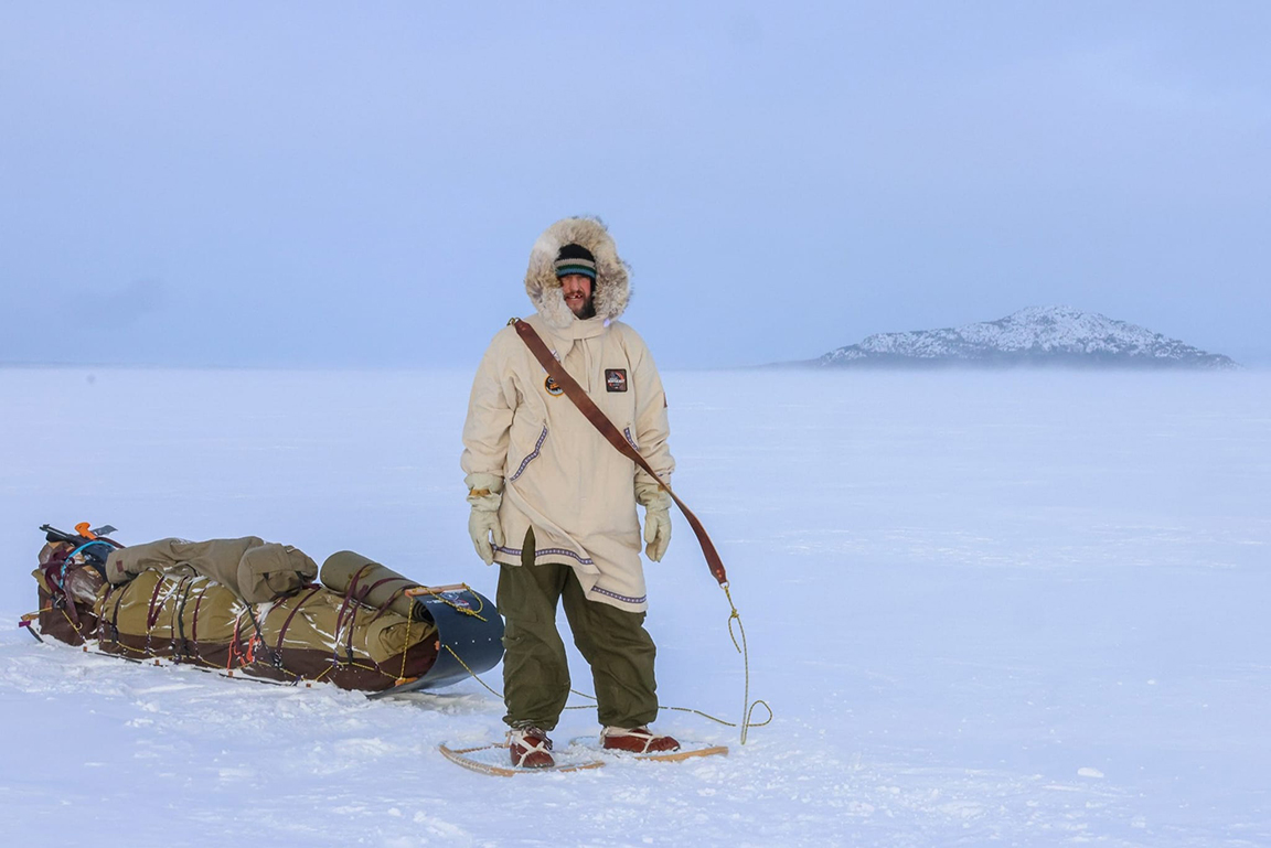
Skis and a fiberglass pulk, like those Antarctic skiers use, would be quicker, but Barbour preferred a traditional style. And his canvas tent, hung from a frame of black spruce trees and heated by a small wood stove, is far more comfortable than a nylon tent in the frigid northern Quebec interior, where temperatures can drop well below -50˚C.
Spring arrives
He stuck as much as possible to open lakes, where the snow was harder than in the open forests of black spruce and tamarack. After several hundred kilometers, he crossed the Trans-Labrador Highway, a wilderness road that connects Labrador with the rest of Canada, and then continued south overland toward the Gulf of St. Lawrence.
But spring was coming on, snow cover was thinning out, forests were thicker, and the south-flowing rivers he had to follow were opening up. The toboggan-hauling season had ended. Rather than wait a month for the rivers to open completely so he could canoe again, he had his helicopter friend convey him 267km back to the Trans-Labrador Highway. Here, he cycled 1,500km to the south coast of Labrador.
By this time, "I was starting to wear thin," he admitted. So he decided against kayaking the 18km Strait to the island of Newfoundland. Instead, he took a ferry across.
Then he hiked another several hundred kilometers to Cape Pine, the southern tip of Newfoundland. In the end, he spent his full year (372 days, to be precise) in the wilderness, traveling by a variety of conveyances -- 1,150km of canoeing, 700km of snowshoeing, 1,500km of cycling, and 550km of hiking.
Barbour admits he's not sure what he'll do next. Such long journeys disrupt every other aspect of one's life, and most ultra-marathon adventurers do only one of these before starting to put down roots. A follow-up project that lasts only one or two months may feel small by comparison, and most tend not to do them. But we'll keep watching Barbour's social media, just in case.
The Italian mountain site montagna.tv has listed ExplorersWeb's Angela Benavides as one of the 50 most influential mountain people of 2024.
Regular ExplorersWeb readers will be familiar with her almost daily coverage of mountain happenings around the world, especially in the Himalaya and Karakoram. Angela doesn't only report the news; she gives context and depth to the alpine stories of the day. Whether it is up-to-the-minute news about an ongoing summit push, an in-depth investigation about the controversial death of a Pakistani porter on K2, or clarifying the byzantine rules around obtaining a climbing permit in Tibet, Angela's tireless work puts her at the core of contemporary mountain journalism.
Others on the yearly list include Kilian Jornet, Jimmy Chin, Francois Cazzanelli, Kilian Jornet, Nives Meroi, and Nima Rinji Sherpa.
Congratulations to Angela!
Henry Howgate was not himself an arctic explorer, but as an influential bureaucrat, he profoundly affected American arctic expeditions in the late 19th century. He was partly responsible for one of the worst disasters in arctic history. But the story of this charming rogue was much, much stranger.
Tall and good-looking, Howgate joined the Signal Corps -- the new division of the army responsible for stringing telegraph wires across the frontier. At some point, he became friends with Adolphus Greely, a lieutenant likewise involved in the early Signal Corps.
Howgate lived in Washington with his wife Cordelia and daughter Ida. He put in long hours and eventually became responsible for dispersing the Corps' funds. The head of the Signal Corps, General Albert Meyers, increasingly relied on his hard-working assistant, especially after Meyers became ill. When Meyers died, Howgate became the Acting Chief Signal Officer.
During his late office hours, Howgate started an affair with a woman in his office, a "fetching redhead" named Nettie Burrill. Nettie reportedly enjoyed the good things in life, and Howgate was happy to accommodate her by using his position to embezzle vast funds from the Signal Corps. It is estimated that he took between $400,000 and $500,000 from government coffers -- up to $15 million in today's dollars. He set Nettie up in a lavish house not far from where he lived with his wife and daughter. Every week, the six-foot-tall, flamboyantly moustachioed Howgate told his wife he had to travel for business and went off to live with Nettie for a few days.
Arctic obsession
During his time at the Signal Corps, Howgate also became fascinated with arctic exploration. It overlapped with his work; the early Signal Corps was involved in a push to extend American influence into the Arctic. Inspired by the British Arctic Expedition of 1875-6 to northern Ellesmere Island, Howgate advocated for establishing a polar colony well north of where even the Inuit lived. The expedition would stay in the High Arctic for years, gathering scientific information and perhaps going to the North Pole.
He even drafted a bill to Congress about it, in a monograph called Polar Colonization. In it, Howgate listed several reasons why past expeditions failed. Most important of all, he wrote, was the men's excessive dependence on the vessel they sailed north in. It created, he said, a "city of refuge" that made them "timid, unadventurous, and irresolute."
Much better, he suggested, to drop them off by ship. The ship would then sail away but return to resupply them every year and pick them up at the end of their stint. He strengthened his case by asserting how easy it would be every summer for a supply ship to reach Lady Franklin Bay, the harbor on Ellesmere Island where the British had based themselves. This theory -- like the armchair theory of the Open Polar Sea from earlier decades -- had dire consequences later.
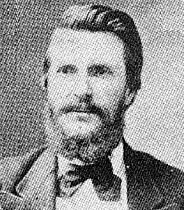
Authorities close in
In 1878, Howgate tried to establish one such colony, but it fell through because of a faulty ship. Undeterred, the energetic Howgate pressed for an expedition to establish his dream colony during the first International Polar Year in 1881. It was likely not a coincidence that his old friend, Adolphus Greely, was chosen to lead that expedition.
Meanwhile, his embezzlement was catching up with him. Rumors circulated about financial irregularities in the Signal Corps, so when General Meyers died in 1880, Howgate applied to become the official Chief Signal Officer. This would allow him to bury his misdeeds indefinitely.
Although Howgate had strong support, he lost out to an even better-connected competitor. Eventually, President Hayes nominated William Hazen for the position. Knowing that Hazen would surely investigate the purported financial improprieties, Howgate resigned from the army three days later and fled to Michigan with Nettie.
By the time Greely left for Ellesmere Island in August of 1881 to establish this three-year scientific polar colony, Howgate's crimes had become public. He was now a fugitive. Authorities traced him to Michigan through money that he sent regularly to his abandoned wife and arrested him.
Daring escape
While awaiting trial, Howgate lived comfortably in jail. His cell was furnished with items from both his Washington homes, and he could visit Nettie regularly under escort to take a bath, since washing facilities at the jail were not to his liking.
On one of these visits, his daughter Ida -- in collusion with her father -- kept the deputy marshal distracted with an hour-long piano recital while Howgate slipped out the back door into a waiting coach with Nettie. They boarded a ship down the Potomac, and the hunt for the escaped fugitive began again.
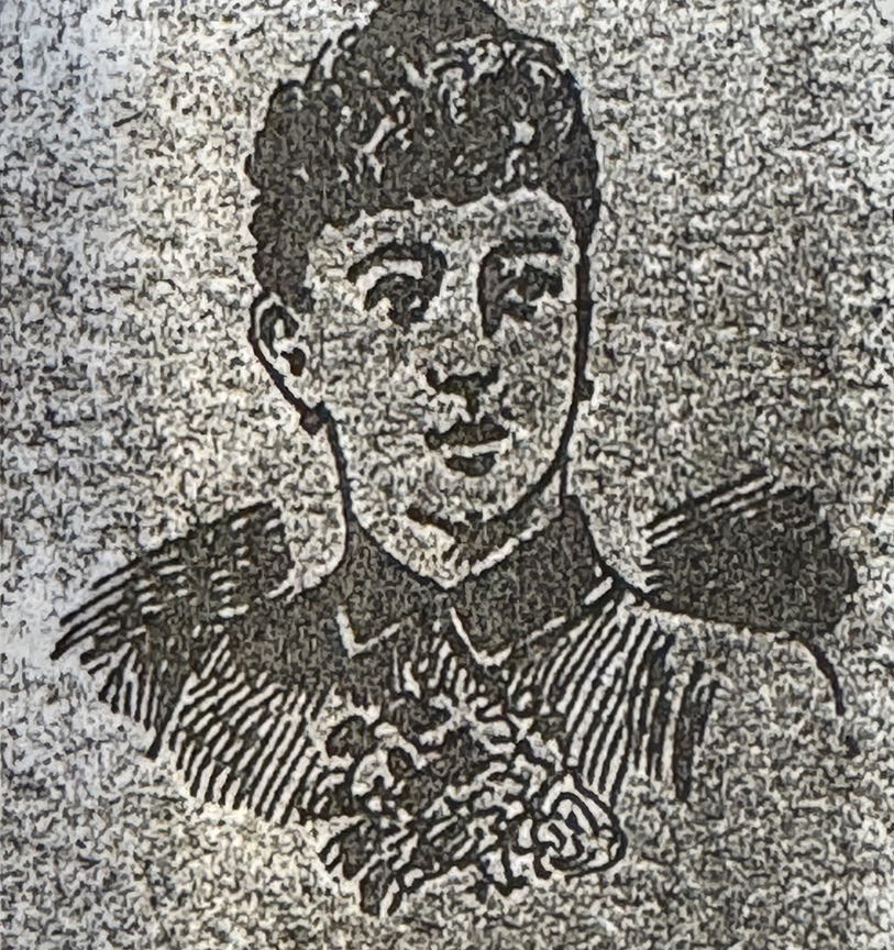
To the public, Howgate was a somewhat sympathetic rogue. Charm and chutzpah went a long way even then.
"When the news of his escape from custody was made known, there was a general feeling of gladness in the community," reported the Washington Evening Star at the time. "Pretty nearly everybody had a sneaking desire that Howgate would never get caught."
A dashing fugitive
Indeed, Howgate was much harder to catch this time. He went back to Michigan and worked as a reporter under an assumed name. A couple of years later, he moved to New York City and opened an antiquarian bookstore under the name of Harvey Williams (his middle name). He had long been a book collector, and back in his Signal Corps days, the funds that he did not allocate to Nettie's upkeep went to accumulating one of the best private libraries in DC.
Robert Todd Lincoln, the eldest son of Abraham and now the Secretary of War, was affronted by Howgate's brazen escapades. When the Secret Service failed to nab him, Lincoln hired detectives from the newly formed Pinkerton Agency and offered a $1,000 reward for his capture.

While this was going on, Greely's polar colony on Ellesmere Island was wishing that, like every other arctic expedition, they had traveled in their own ship. A leased vessel, the Proteus, had successfully dropped them off at Lady Franklin Bay with supplies for at least two years. The following summer, the Proteus was to return with more supplies and mail from home, and to swap out personnel.
Arctic theory meets reality
However, Lady Franklin Bay was not as accessible as Howgate had theorized. While the ice of the previous winter reliably melted away, thick, multiyear pack ice flowed south from the Arctic Ocean down the narrow channel between Ellesmere Island and Greenland, often blocking the way.
Even today, only icebreakers dare venture in that area. About 20 years ago, a cruise ship tried and got stuck in the ice. It was just coincidence that a nuclear icebreaker was in the vicinity off northern Greenland and was able to free it.
In 1882, the Proteus couldn't reach the polar colony because of ice. It tried again in 1883. It not only couldn't reach Lady Franklin Bay; it was crushed in the pack ice some 300km to the south and sank.
Lacking a ship of his own, Greely was under orders that if no vessel reached them by late 1883, they were to work their way south in the small whaleboats they had with them. Presumably, they would encounter the Proteus eventually. In a decision that his men vehemently disagreed with, Greely insisted that everyone abandon the still well-stocked station and head south, as ordered.
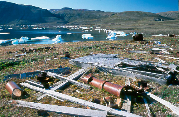
Tragedy strikes
After a heinous two-month trip over broken, shifting ice, and with winter coming on, Greely and his men made it halfway down Ellesmere Island. There, a cairn note gave them the deadly news: The Proteus had sunk, and the sailors aboard had saved themselves by heading to Greenland in lifeboats. They had managed to leave only 40 days of supplies for Greely's 25 men.
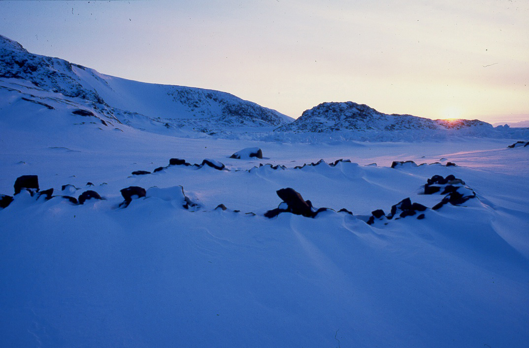
No ship would make it there for at least another eight months. Eight months, with 40 days of food on a barren coast with the High Arctic winter setting in. How they must have longed for their own well-laden "city of refuge" now.
Their famous ordeal, in which 19 of the 25 died, mostly of starvation, is another story. A rescue ship finally reached them in June 1884. That six survived was a miracle. Although he was a skinny man at the best of times, Greely, incredibly, was one of the survivors.

Rare book dealer
Meanwhile, the fugitive Henry Howgate remained at large as a rare book dealer in New York City. When Greely returned to Washington, General Hazen hit the roof when he saw that Greely had named several features on Ellesmere after his disgraced friend. Needless to say, Howgate's name was purged from those places.
From hiding, Howgate cheekily wrote Greely to protest. If Greely couldn't reinstate Howgate's name on those geographical points, he argued, perhaps he could name something after his daughter Ida? Despite leading the most disastrous arctic expedition in U.S. history, Greely had become famous, America's most celebrated polar expert, and a career officer on the rise. He didn't respond to Howgate.

Captured
Howgate evaded detection for almost a decade. Then in 1894, A.L. Drummond, one of the Secret Service agents in charge of the original manhunt, retired and moved to New York to open his own detective agency. Coincidentally, he heard about a tall, distinguished rare book dealer who frequented many local auctions. Drummond recalled that Howgate was a bibliophile and began to suspect that this might be their elusive fugitive, especially when he heard that the grey-bearded book dealer lived with an attractive, much younger woman.
Drummond confronted the suspect as he emerged from his bookshop. "How are you, Captain Howgate?" he asked.
Howgate didn't try to deny it. "Yes, I'm Howgate," he admitted. "I'll go with you. I'm beat."
He was taken back to Washington, where the ever-faithful Ida posted his bail. He lived with her while awaiting trial. His old charm seemed not to have failed him, and he was initially acquitted. But at a second trial on follow-up charges, he was found guilty and sentenced to 15 years. He was 60 years old.

In 1900, after five years in prison and in failing health, Howgate was paroled. He died soon after.
His old friend Greely lived decades longer and became a celebrated general. Two features on northern Ellesmere Island, Ida Bay and Ida River, are named after Howgate's daughter.
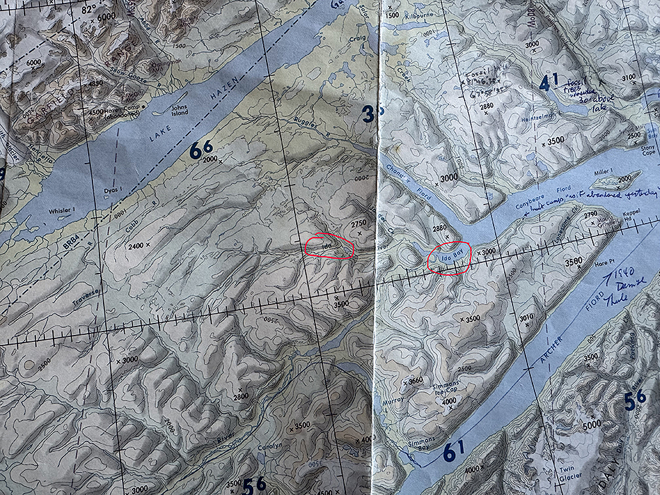
An emperor penguin that swam 3,500km from Antarctica to Australia was released back into the chilly waters of the Southern Ocean this week.
The only emperor penguin to make such a marathon migration, Gus -- as his caregiver, Carol Biddulph, dubbed him -- had gained weight during his time as a minor Australian celebrity. He was a scrawny 21 kilos when he unexpectedly waddled onto a beach in southwest Australia on November 1. Under Biddulph's care, he increased to a slightly more stocky 24.7 kilos.
Healthy male emperors can weigh more than 45 kilos. But wildlife officials felt it was important to turn Gus loose before the Australian summer made life even more difficult for a creature more used to -40 than +40˚C.
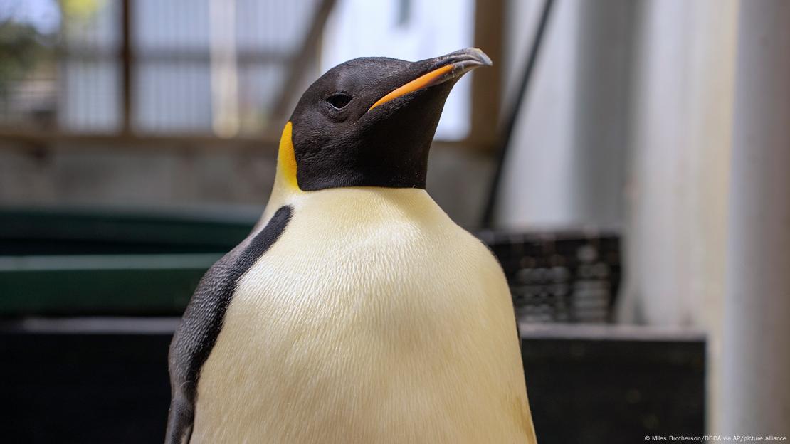
“I really didn’t know whether he was going to make it to begin with because he was so undernourished,” Biddulph said in a video released today by the government.
As she had done with other orphaned penguins, Biddulph added a mirror to his enclosure for company so that the social bird would not feel quite as solitary.
"I think that has been crucial in his well-being," she said. "He [stood] next to the mirror most of the time.
The boat traveled several hours into the ocean before Gus was released, so he had a bit of a head start.
"I've got every faith he will get home," she added.
Food-habituated bears sometimes break into backcountry cabins and cars at campgrounds. Once every long while, there are disturbing human-bear conflicts. But sometimes, bears just get accused of things they didn't do.
Last month, a bear was initially blamed for killing Montana camper Dustin Kjersem. State police later charged a human suspect with murder. And this week, law enforcement authorities in Los Angeles arrested four men in a bizarre insurance scam.
The men are accused of trying to bilk two insurance companies out of nearly $142,000 by blaming a bear for damage to a Rolls Royce and two Mercedes in the San Bernardino Mountains earlier this year.
In two separate claims to different companies, the men provided a grainy, nighttime video of the marauding "bear" inside the vehicles. They also showed what appeared to be claw marks on the seats and doors.
But something was fishy. Insurance investigators believed that they were watching not a bear but “clearly a human in a bear suit,” the insurance department said.
To confirm their suspicions, they sought out the expert opinion of biologist Kevin Howells with the California Department of Fish and Wildlife. Howells pointed out “visible slack in the suit.”
“As soon as the bear came into frame, to me, it was pretty quick and fairly obvious that it was not [a real bear],” Howells told The Washington Post.
Detectives executed a search warrant for what had been dubbed Operation Bear Claw and found the costume in one of the suspects' homes.
For centuries, when the Inuit hunters of North West Greenland noticed that their dog teams had begun to lose their vitality, they had a simple but little-known solution.
They would stake out females in heat in an area frequented by wolves -- often on what is now Canada's Ellesmere Island, a short 50km trek across a frozen channel. Wolves are more common there. When the hunters came back for the females a few days later, they were usually pregnant.
According to Manumina Lund Jensen, who has studied this ancient practice, the first generation of pups wasn't suitable as sled dogs. Their forelegs were too long, and they were too ferocious to work in a team.
Greenlander Ole Jorgen Hammeken learned about this almost-forgotten tradition from elders years ago.
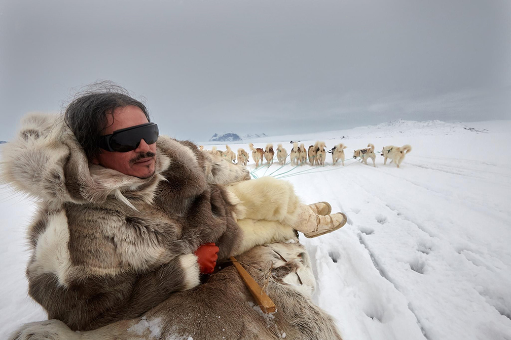
"In 1997, I embarked on an ambitious 2,000km expedition from the island of Uummannaq to Neqi, passing through Qaanaaq and Siorapaluk," he told ExplorersWeb. "Few had completed such a feat before — Guido Monzino being one of the few I knew who had.
"I understood the importance of having exceptional dogs for such a long journey. In 1995, I traveled to Illorsuit, a now-abandoned settlement in Northern Greenland, to learn from the elders. They shared with me an old tradition for strengthening sled dogs when the pack showed signs of weakening.
Revitalize the bloodline
"For the first time, I heard of the ancient practice of mixing dogs with wolves. The elders explained that when the dogs' bloodline began to lose its strength, they knew it was time to revitalize the pack. Their method had endured for millennia. They took a female dog in heat and left her far from the settlement, in areas where wolves were known to roam.
"The resulting puppies would be half-dog, half-wolf. However, the first generation was too wild for sled work, and so were the second and third. These early generations were unpredictable, pulling left or right instead of running straight. Only by the fourth generation did they become reliable sled dogs, having adapted to human companionship and training.
"By the time I used them, they were many generations removed from their wolf ancestry, but the legacy of those strong, resilient dogs remained."
The Royal Meteorological Society has announced the winners of the Standard Chartered Weather Photographer of the Year contest.
Wang Xin was outside Shanghai during an intense thunderstorm when he captured a flicker of red between the usual white bolts of lightning. This phenomenon, known as red sprites, occurs now and then in the upper atmosphere, but it doesn't last long.
Andy Gray's moody image of a frosty scene in North East England took the runner-up prize. Jamie Russell, also from the UK, won third for a beautifully framed aerial image of a rainbow over a chain of islands.


The category winners and finalists were not too shabby, either. The Smartphone winner showed a volcanic landscape in East Java, with an isolated puff of smoke above the most distant cone. Second place went to an image of Athens that might have used an orange filter but didn't. Fine dust from North Africa colored the sky over the European capital.
There was also a Youth category for photographers 18 and under and a climate award.
You can view a selection of other winning images here.


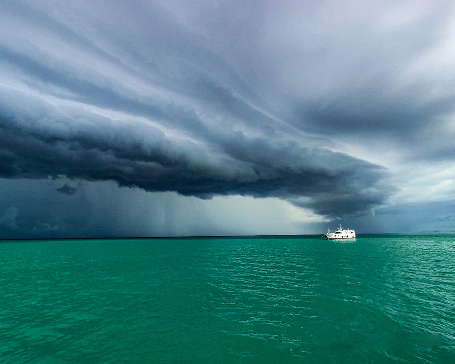
For the eleventh year, October 23 marks International Snow Leopard Day. Only 3,500 to 7,000 of the beautiful speckled cats, listed as vulnerable by the International Union for Conservation of Nature (IUCN), remain.
The snow leopard lives in 12 of the most mountainous countries in the world -- Afghanistan, Bhutan, China, Kazakhstan, Kyrgyzstan, India, Mongolia, Nepal, Russia, Pakistan, Tajikistan, and Uzbekistan. Typically, the greyish felines roam at altitudes of 3,000m to 5,200m, often stalking high-altitude ungulates such as blue sheep and ibex.
For years, snow leopards were so elusive that only local people ever saw them, rarely and at a distance. With a better understanding of their habits, patient visitors are often able to spot them, especially in India and Bhutan.
Last year, India's first-ever snow leopard survey pegged the number of cats at 718. Bhutan has 134 snow leopards, while in Nepal, the number ranges from 300 to 500.
"A cloud of cumbrous gnats do him molest,
All striving to infix their feeble stings,
That from their noyance he no where can rest.”
– Edmund Spenser, The Faerie Queene (1552-1559)
Most of us can sympathize with Spenser’s hero. In some places, hungry flies can turn summer into hell on earth. We can tell ourselves that every living creature has its role in nature, but even the Dalai Lama admits that compassion for the mosquito is difficult after the third bite.
Today, we have many ways to fend off mosquitoes and black flies, but they all carry minuses: the repellent DEET is oily and dissolves plastics and nylon. Insect-proof clothing turns hot days into sweatfests. You can barely see through a head net, especially when looking into the sun. Relieving yourself outdoors takes preparation, timing, and speed.
Even when you’re well-armored against bites, mosquitoes and black flies are so abundant in parts of the North that they dominate one’s consciousness. Close your eyes at the end of a day and all you see are specks, specks, specks.
No-see-ums and deer flies add their personalities to the torment mix. No-see-ums combine near-invisibility with a bite vastly out of proportion to their size. They aren’t dubbed flying jaws for nothing. And deer flies exhibit a maddening stubbornness once they start orbiting you on a sunny day. But their numbers don’t compare to those of mosquitoes and black flies.
Blue jeans turn grey
Whatever the blood-hungry insect, the North serves them up like no other place on Earth. Where else can blue jeans turn grey with mosquitoes, or your hand leave an imprint in squished flies on your partner’s back? Yet travelers still rave about their tundra trips and chalk the bugs up as one more challenge overcome, like a difficult portage or a bear shooed from camp. Afterward, the welts and scabs feel like hard-won medals from a true adventure.
But does it really have to be so brutal? Drawing from local lore and historical accounts from agonized explorers, plus briefs from bug-obsessed biologists, this guide to winged misery lets you know your enemies –- the better, as Sun Tsu points out in The Art of War, to have them at your mercy.

12.5 million mosquitoes per hectare
Studies of our mosquito and black fly populations are rare –- would you want to earn your PhD counting blood-sucking insects? -- but a few hard-bitten researchers have unearthed shocking results. The Hudson Bay lowlands have 12.5 million mosquitoes per hectare of a single species, and you need to multiply that at least threefold to account for the other mosquito species present.
Some boreal rivers in Canada have 750,000 black fly larvae per square meter. Black fly larvae on a single river in northern Sweden produce 69 tonnes of excrement per day. That's just their excrement.
The clearest picture of mosquito and black fly numbers comes from accounts of afflicted explorers.
“Backs and hats were brown with the vicious wretches,” wrote northern traveler H. Hesketh Prichard, who devoted a whole horrified chapter of his 1911 book, Through Trackless Labrador, to what he called the Kingdom of Beelzebub.

Indescribable
“What these mosquitoes are is indescribable,” Prichard continued. “They give no rest, no peace. Day and night they go on and on and on.”
“Nearly demented,” he noted in his journal a day later.
Naturalist Ernest Thompson Seton may have left the best literary record about northern mosquitoes. He regarded the Grey Terror with a scientific enthusiasm that belies how unpleasant his experiences were.
“On six square inches of my tent, I counted 30 mosquitoes, and the whole surface was similarly supplied,” he recalls in his 1911 classic, The Arctic Prairies. “That is, there were 24,000 on the tent…They reminded us of Klondike gold-seekers. Thousands go; great numbers must die a miserable death; not more than one in 10,000 can get away with a load of the coveted stuff, and yet each believes that he is to be that one, and pushes on.”
Mosquito gauge
Seton’s most memorable invention was his mosquito gauge: “Mere adjectives could not convey any idea of their terrors,” he explained. So as he traveled different parts of Canada's Northwest Territories, he periodically removed his glove, then tallied the number of mosquitoes that alighted on the back of his hand in five seconds.
In one spot, he counted five to 10; near Fort Resolution, 20 to 40. But deep in the Barren Grounds, that area of tundra ponds, streams, and mossy plains north of Manitoba, took the record: 100 to 125 mosquitoes on one hand in five seconds.
“It was possible to number them only by killing them and counting the corpses,” he writes.
As the contrast between Seton’s curiosity and Prichard’s anguish suggests, some of us are psychologically more pained by swarming flies than others. It’s not just stoicism. Even the tough First Nations people, who endured this yearly plague for centuries, were hardly indifferent. When explorer Knud Rasmussen traveled across northern Canada early in the 20th century, he found that the second most popular trade item, after sewing needles, was mosquito netting. The people he met may have been tough, but they weren’t crazy.
'Little fly'
Mosquitoes –- Spanish for “little fly” –- have been on earth for more than 100 million years. They’ve sunk their proboscises into everything from velociraptors to early hominids.
Currently there are about 3,500 species worldwide, and 74 in Canada and Alaska. Just two cold-resistant types inhabit the arctic islands, and their numbers taper the farther north you go. The High Arctic has hardly any, except in mild enclaves called polar oases.
But as the climate warms, their beachhead is expanding: Residents of normally mosquito-free Grise Fiord, the northernmost village in Canada, have noticed a few in recent summers. Even though there currently aren't many, "people freak out when they see one or two," says one resident.
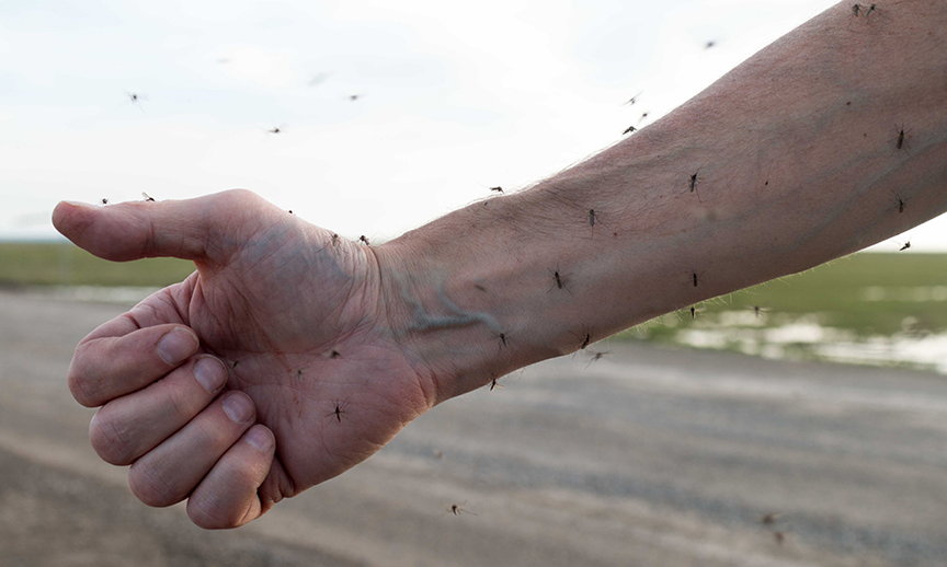
According to a native legend, originally there were just two mosquitoes. They were tall as pine trees and ate people whole. When men finally surrounded and killed them, swarms of tiny replicas sprang from their spilled blood. Today, they bite us out of revenge.
The voyageurs believed that a certain saint, banished from heaven for disobedience, had to live alone for eons in an uninhabited part of the world as punishment. In her loneliness, she prayed for a few flies to keep her company. She didn’t expect the flies to bite. When the saint was let back into heaven, the flies stayed on earth to remind us of the folly of trying to distract from the consequences we’ve brought on ourselves.
The world’s most dangerous animal, mosquitoes carry West Nile virus, encephalitis, and many other diseases, especially malaria. Malaria infects 247 million people worldwide each year and kills a million. A simple mosquito bite single-handedly transmits the disease, says the World Health Organization.
Airport malaria
Discounting travelers who bring back the disease from overseas, the main incidence in some places is so-called airport malaria, caught near airports from disease-bearing mosquitoes that have hitched on international flights.
Only female mosquitoes bite (so they can nourish their eggs with blood’s protein). They hunt their prey like a homing missile. When a mosquito detects carbon dioxide from breath –- from as far as 35 meters away -- it flies a zigzag course toward higher concentrations to locate the source.
As it closes in, other cues take over, including body odor, heat, and sight. Perfume attracts them, as do stinky feet, which contain an alluring bacteria also found in Limburger cheese. When mosquitoes are about three meters away, they use sensitive thermal receptors on their antennae to locate blood beneath the surface of the skin.
The range of these receptors triples in high humidity. While black flies gnaw a messy crater and then lap up the pooling blood, mosquitoes insert a double-barreled straw. Through one straw, they inject an enzyme that inhibits clotting and causes itching and a bump on the skin. They use the other straw to suck up blood.
Three times its weight in blood
A mosquito can drink up to three times its weight in blood, but it would take more than a million bites to drain all the blood from an adult human. Urban myths aside, this couldn’t happen, even to a naked person on the tundra, because swelling would create a watery fluid barrier that would keep late-arriving legions from accessing the blood.
Still, the number of bites a body would have to endure in order to reach this agonizingly swollen, protective phase would be in the thousands. One researcher inserted his bare arm into a cloud of mosquitoes and got 289 bites in a minute.
Less ubiquitous than mosquitoes, black flies still terrorize bush country, attacking in clouds. Burrowing through the protective fur of mammals to the soft skin beneath, black flies are particularly –- some say diabolically -– adept at finding their way through the smallest chinks in clothing. They also like ears, scalps, wrists, ankles, the belt line, and other areas where clothing has pinched the skin tight.
The small white stripes on the legs of our most common species give rise to one of their many nicknames, white socks.
The tormentor
Worldwide, there are more than 1,250 species of black flies. In the Canadian North, where they are most abundant, they reach as far as Baffin and Banks Islands, but the High Arctic is blessedly free of them. The most common Barren Ground black fly has the species name of tormentor. Another northern species is irritatum. Scientists aren’t above putting their personal feelings into their work.
While mosquitoes hatch in stagnant water, black flies prefer running streams. The females lay their eggs (150 to 600 per season) on submerged objects. The larvae attach to rocks and underwater vegetation and filter feed on drifting nutrients. They’re sensitive to pollution, so the presence of black flies indicates clean water. A small consolation.
Black fly numbers increase toward sunset but they don’t bite at night. Nor do most species bite indoors. This includes tents, houses, and even vehicles with open windows.
inside, black flies become disoriented. In a tent, for example, they lose interest in biting and crawl up the netting, trying to escape. It’s easy to unzip the door and brush them outside. For campers, it’s a welcome reprieve from sneaky mosquitoes, which will bite indoors night and day.
The black fly's weak spot
Scientists aren’t sure why black flies don’t like a roof over their heads. “If we could bottle whatever it is, we could make a lot of money,” says entomologist Tom Chapman of Memorial University in St. John’s, Newfoundland.
Black flies sometimes swarm cattle in such numbers that they kill them. The cattle don’t die from blood loss but from anaphylactic shock. The saliva that the flies inject to keep blood from clotting can affect sensitive people too, especially after hundreds of bites.

Some northern expeditions, such as the famous 1903 Leonidas Hubbard expedition in Labrador, suffered from black fly fever. “They got into our nostrils, into our ears, into our mouths, into our eyes even,” wrote one of Hubbard’s companions. “They were villainous, hellish."
Hubbard frequently remarked that the mosquitoes seemed friendly in contrast. "For ten days, I was fairly sick from the poison the [black flies] instilled.”
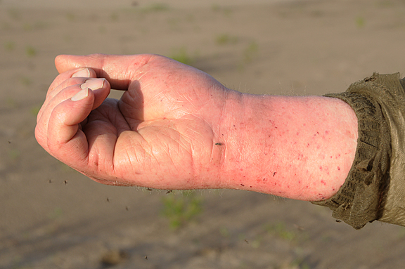
Deterrents
Monty Python once performed a skit in which mosquitoes were gunned down with automatic weapons and blown up with grenades. Although we might yearn for such revenge, quieter deterrents are more effective. Since 1957, DEET has been the gold standard in repellents. Developed by the military after World War II, DEET was thought to blind the insects’ senses so the biting instinct didn’t kick in.
It turns out this isn’t quite true. Recent studies suggest that DEET acts as a true repellent. Mosquitoes simply hate the smell of the chemical, even though it doesn’t seem to affect their ability to detect carbon dioxide.
DEET comes in sprays, oils, roll-ons, and lotions of varying strengths. You can still buy 100 per cent DEET in the United States, but Canada limits consumer products to 30 per cent or less because of the skin irritation some users suffer. Higher percentages of DEET don’t repel better; they just last longer.
An alternative repellent developed in the 1980s called Picaridin is reportedly as effective as DEET and doesn’t cause skin irritation. Unlike DEET, it also won’t dissolve the arms of your sunglasses or a plastic watch strap.
Dozens of traditional concoctions and modern inventions claim to keep biting flies at bay. None do as well as the certified test tube products, though. Citronella works for less than an hour. Avon Skin So Soft moisturizer is celebrated for its accidental repellent properties but also doesn’t last.
Ultrasonic devices and bug zappers do nothing. Neither do Vitamin B tablets. Garlic works for 20 minutes or so when rubbed on skin but not when eaten. And contrary to myth, bananas don’t attract biting flies, so eat away. But drinking beer does seem to make a person more attractive, at least to flies.
Picture this: You’re running in the mountains alone with minimal gear and just one liter of water. But this isn’t a day trip in the Rockies — you’re in the Himalaya ascending Manaslu, the eighth-highest mountain in the world. And you’re doing it without supplemental oxygen or climbing partners.
Sound risky? Tyler Andrews, a 34-year-old endurance athlete from Massachusetts, would be the first to agree. The runner has racked up an impressive list of feats on dangerous mountains, including 69 Fastest Known Times (FKTs), placing him in the ranks of the world’s most elite runners.
Last year saw several of Andrews’ most impressive records yet. He set new FKTs on Tanzania’s Mount Kilimanjaro and Argentina’s Mount Aconcagua. On both mountains, Andrews pulled ahead of past records set by running legends like Karl Igloff and Kilian Jornet.
But this week, Andrews told us he wants to be “the best in the world.” That’s why he decided to test his skills on the biggest stage of all: the Himalaya. On Sept. 19, Andrews hiked up the 8,163m Manaslu in 9 hours and 52 minutes, shaving more than two hours off the previous record, set by Nepalese climber Pemba Gelje Sherpa last year.
These mountains have typically been the realm of mountaineers — not trail runners. Many of them require sections of vertical climbing, which is why Fastest Known Time has long excluded speed records on those mountains, allowing The Himalayan Database to track them instead.
But now that’s changing, thanks in part to Andrews, who also works part-time for the FKT organization. Since the primary route on Manaslu lacks technical climbing, he thinks turning the summit push into an FKT is fair play. And he believes the training he’s applying to these mountains — like bringing a stationary bike to Manaslu base camp — represents a novel approach to Himalayan adventure.
We caught up with Andrews to find out how he did it — from nutrition and gear to timing and technique.
Congratulations on setting a new FKT on Manaslu You’ve set many records already. Can you tell us what this one means to you?
Andrews: I mean, first of all, it’s my first 8,000m speed record. So that’s really special. But honestly, I think the thing that made it the most special is that I tried and failed a year ago.
And the way that the big mountains go is you often only get one shot a year. And that kind of sucks, but it definitely makes it more special when things go really well. I think the bigger the mountain, the bigger the stakes, the bigger the stage, the more important the preparation — all that stuff. And to have it go so well after what was objectively a pretty rough year, that just makes it doubly special.

Where and how does run training/aerobic development factor into prep for outings like this, along with all the other variables you’re trying to train for?
This article first appeared on GearJunkie.
On August 6, a bald eagle near Boulder, Colorado was perched on a dead branch, keeping a close eye on a red-tailed hawk near the eagle's nest. The eaglets had already fledged and left, but eagles often reuse their nests, so the bald eagle was monitoring the intrusion on its territory.
Suddenly, a bolt of lightning caused the nest to explode in a fireball. A wildlife cam stationed 450m away caught the rare event. The electricity stunned both the unseen hawk near the nest and the eagle, which dangled upside-down for several minutes. Then, incredibly, it recovered and flew away. No word on the hawk, which had chosen a bad time to investigate the nest and was likely fried.
Since then, local volunteers have spotted the eagle and her partner looking for a new nest site in the neighborhood. Officials have closed a nearby trail until they are done.
Check out the explosion below. The hawk is not clearly visible, and the video ends before the stunned eagle recovers and flies away.
Some Inuit men were on a fall caribou hunt south of Igloolik, on Baffin Island in the Canadian Arctic, when a young polar bear ripped open the door of their Arctic Oven-style tent as they slept.
"One of the scariest [experiences of] my life!" said one of the men, Joe Uttak of Igloolik in a post yesterday on the Facebook group Inuit Hunting Stories. He included a photo of just how close the bear came to them. It was halfway inside the tent when one of the men, identified only as Terry, shot the animal.

Most dangerous encounters between humans and polar bears involve young animals. The adolescent bears are curious, and their curiosity and opportunism can quickly escalate into a predatory encounter. Many northerners will stake a dog outside the tent as they sleep. The dog will bark at an approaching bear, giving those inside time to chase it away before it can approach as closely as this one did.
In Canada, each Inuit village has a yearly quota of polar bears that its residents can hunt as part of their traditional culture. Defense kills such as this one come out of the quota of the nearest village.
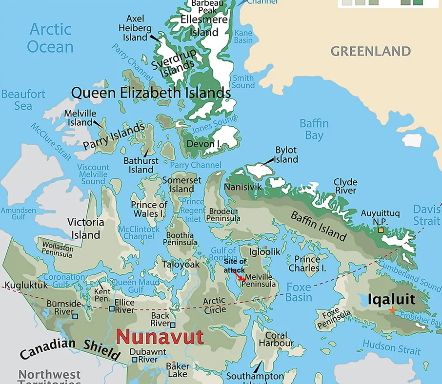
Zach Fritz and Taylor Rau are experienced canoeists but had never tackled anything on this scale before. For 105 days, beginning in mid-May, the two Minnesotans paddled 4,400km from Fritz's family cabin in Minnesota's North Woods to Chantrey Inlet, Nunavut, on the shores of the Arctic Ocean.
Both had their introduction to canoeing through a local program called Les Voyageurs, which took high school students on 30 to 45-day canoe expeditions in northern Canada. The two returned to work as guides for the program. At a turning point in their lives, they decided to tackle a big journey.
Fritz mapped out the way, studying the accounts of fur traders and explorers. The northern part of their route included the classic Barren Ground rivers -- the Kazan, the Dubawnt, the Thelon, and the Back.
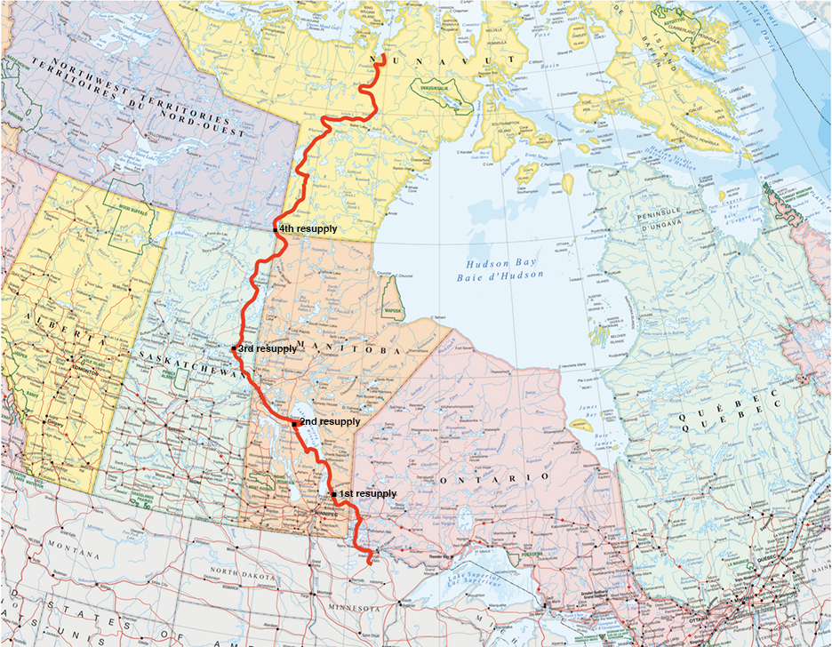
Excerpts
Excerpts from their blog give the flavor of an immense journey, well-planned and carefully executed:
We pushed off in Big Falls, Minnesota early on May 6 with a beautiful first day. The Big Fork River had a wonderful current and some amazing scenery to go with it.
We quickly jumped onto the Rainy River and headed west, where we were met with some rainy days, but a lovely tail wind. We used our sail to help us make some good distance on the river. Quickly, we were in a routine and able to get ourselves a day and a half ahead of our schedule.
Toward the end of the Rainy River, we officially crossed into Canada and moved onto Lake of the Woods, our first of several large lakes to cross.
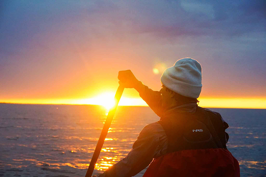
We are leaving the Winnipeg River system tomorrow and working our way north and across Lake Winnipeg -- the biggest lake of our trip. We are expecting to have a more irregular schedule, as we move when the wind will allow us.

Saskatchewan River
At the end of the lake, a large, expansive wetland, where the Saskatchewan River flows into the lake, was like a big maze...What we saw in front of us and what was on the maps were very often conflicting. There were many braided channels to take. A few attempts through reedy passages that either ended abruptly or fizzled into nothing finally brought us into the main lazy channel with tall grasses hemming the rivers shoreline.
For several days, the current of the river increased and so did the size of the river. Its long, winding bends forced us to stick close to shore and follow the inside bends of the river to paddle with the slowest current against us. Going upstream, our strokes felt heavier and sluggish and our muscles working much harder.
The Saskatchewan reminded us a lot of the Mississippi River back home, with similar width, current, and milky waters. The rivers edges were lined with grassy, willow shores and an abundance of poplar and box elder trees.

A long day
For our first full day on the [Sturgeon Weir] River, we waded, lined, and pulled our canoe up almost continuous sets of shallow rapids. Constantly getting in and out of the canoe, paddling against the current when we could, then either pushing or pulling the canoe when the current was too strong. It was a very long day.

Throughout our time on the Kazan, we only had one portage to do to avoid a nasty rapid early on. The rest of our time on the river was spent traveling down its large, fast flowing channels with easy whitewater here and there. Just about the best paddling anyone could ask for...
Day by day, we slowly saw the trees leave, patches here and there would appear on the hillside, but largely disappeared after we left Ennadai Lake. As we transitioned from the treeline to the tundra, we began to see new wildlife and plants along our route. The Kazan offered us our first of many caribou, muskox, and more varieties of birds than we could keep track of.
Windbound
We began following what seemed like a decent river. Very quickly, our hopefulness faded as the river practically dried up to rocks. We knew quickly we were in for a very long day...
We spent the next few days finishing up the big lakes of the Thelon. For the most part, the winds were tricky side winds from the north, and finally, on our last day on Aberdeen Lake, the north wind became too strong and we had to call it a windbound day shortly after lunch. The north winds brought cold temps off the Arctic Ocean. Bundled up, we fished from camp and caught some more beautiful lake trout...
Finally, about 5:30 am on day 105, we took our final paddle strokes across Cockburn Bay and onto Victoria Headland along Chantrey Inlet on the Arctic Ocean. Arriving at our final destination, we had been paddling for almost 24 hours straight and gone well over 100km during that time. Our canoe beached, we gave each other a hug of excitement...

In an interview with MRPNews, the canoeists admitted they aren't planning any further adventures in the immediate future. Fritz has just relocated to Wisconsin, where his girlfriend lives, and Rau has begun a new job.
The shortlist for this year's Boardman Tasker Award for Mountain Literature has been announced. It features six books, including several by familiar authors.
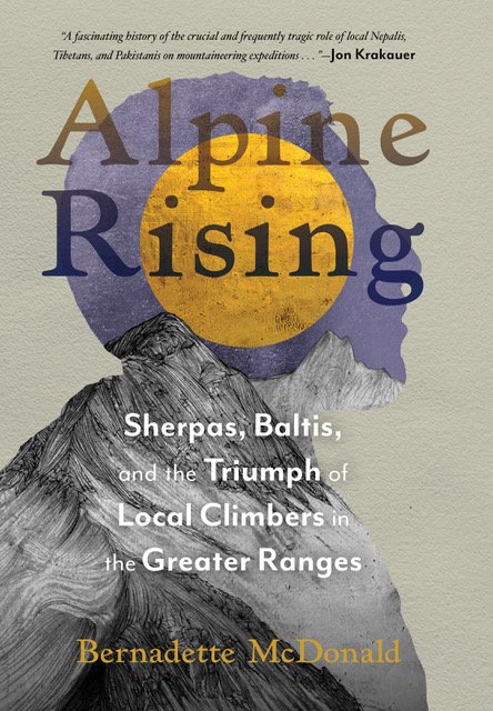
Bernadette McDonald's Alpine Rising: Sherpas, Baltis, and the Triumph of Local Climbers in the Greater Ranges focuses on the underappreciated roles played by Nepali and Pakistani climbers, especially on the future of high-altitude endeavors.
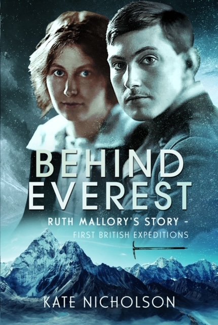
Behind Everest: Ruth Mallory's Story, by Kate Nicholson, weaves Ruth Mallory’s personal struggles and contributions into the often-murky history of women in early 20th-century mountaineering.
Clive Oppenheimer's Mountains of Fire: The Secret Lives of Volcanoes explores the intricate relationship between volcanoes and humanity.
Headstrap: Legends and Lore from the Climbing Sherpas of Darjeeling, by Nandini Purandari and Deepa Balsavar, offers a captivating glimpse into the lives of the legendary mountaineers who populate the "Kathmandu of India."

David Smart's latest book, Royal Robbins: The American Climber details Robbins’ journey from a troubled upbringing to a legendary climber.
A Fine Line: Searching for Balance Among Mountains, by Graham Zimmerman, is an introspective account of the challenges faced by modern alpinists.
Justin Barbour has been home for about 40 days after his year-long journey canoeing, snowshoeing, hiking and biking 3,890km from northern Quebec through Labrador to the southern tip of Newfoundland. "My feet are just coming back to life now," he says.

The journey from Puvirnituq to the Cape Pine lighthouse is not an iconic route like skiing to the South Pole, but it's an original route, and he did it his way. That meant being flexible with his decisions. As a one-off project that no one will re-do in the near future, he didn't have to worry about fine points like "unsupported." He did what made sense, both from the travel conditions and from how he felt.
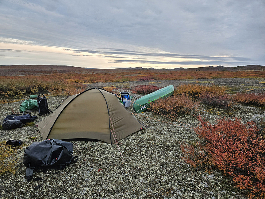
Thus, last fall, he didn't quite make it by canoe all the way to the village of Schefferville before winter set in. He was 210km short. So a helicopter pilot friend picked him up and flew him to Schefferville.
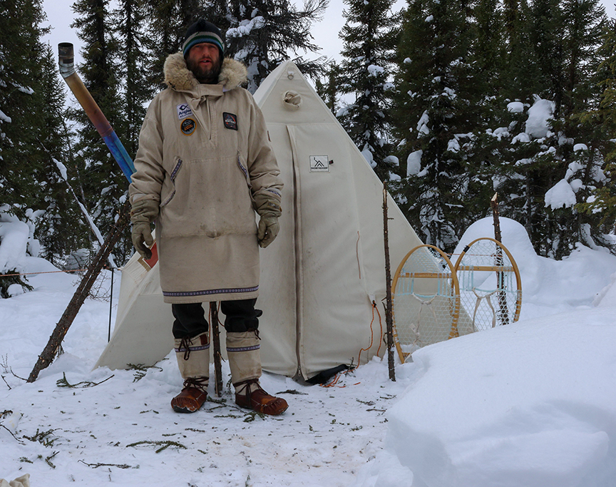
Waiting for winter
Here, he lived in his bush tent just outside town for several weeks until winter had firmly frozen all the lakes, creeks, and rivers that he used as highways. Then on January 1, his friend flew him back to where he had left off, and Barbour started the snowshoe leg of his journey.
Months later, as the subarctic spring was coming on, he had the opposite problem. He'd already traveled 267km from the Trans Labrador Highway through southern Labrador. But in early April, the rivers of southern Labrador were beginning to open up, and he could not drag his toboggan overland through the thicker forests. He needed those waterways.
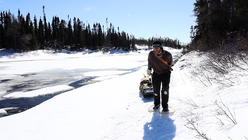
"I didn't want to wait four weeks [for the canoeing season]," he said. So his helicopter buddy again stepped in and conveyed him back to the Trans Labrador Highway, which he'd first snowshoed across weeks earlier. Here, he decided to mountain bike the length of southern Labrador instead of traveling cross-country. He camped along the wilderness roadside at the end of each day.
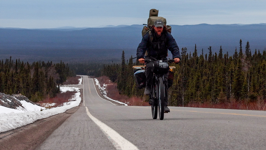
Last sections
Finally, he decided that he didn't want to kayak the 18km or so across the Strait of Belle Isle from Labrador to the island of Newfoundland. It had been raining for days, and "I was starting to wear thin," he admitted. There was also the additional logistics of getting a kayak over to him. So he took the ferry across, then began to hike across that big island to its southern tip.
When you're out for a few weeks on a trail that hundreds of people do, like Hercules Inlet to the South Pole, these mechanized shortcuts matter. When you're out for an entire year on a route all your own, they don't. They become sensible adaptations in what remains a mega-trek.
Barbour's final tally of self-propelled travel:
Canoe: 1,150km
Snowshoe: 700km
Bike: 1,500km
Hike: 550km
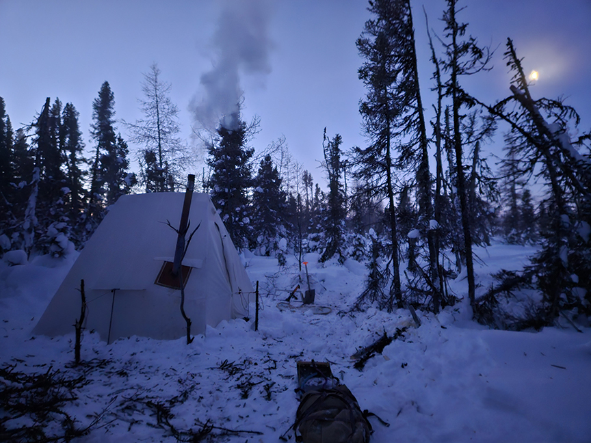
Old-fashioned travel
During his year-long journey, he largely traveled the traditional way, pulling a toboggan and using snowshoes like the region's Innu people or Labrador's Height of Land trappers. In winter, his wood-heated bush tent let him dry his clothes at night. While heavier than the modern mountain tent he used during the canoe section in northern Quebec, it also made heavy expedition parkas and sleeping bags unnecessary. "The more you know, the less you need," he said.
And while he resupplied at several spots, he also hunted ptarmigan and fished along the way.
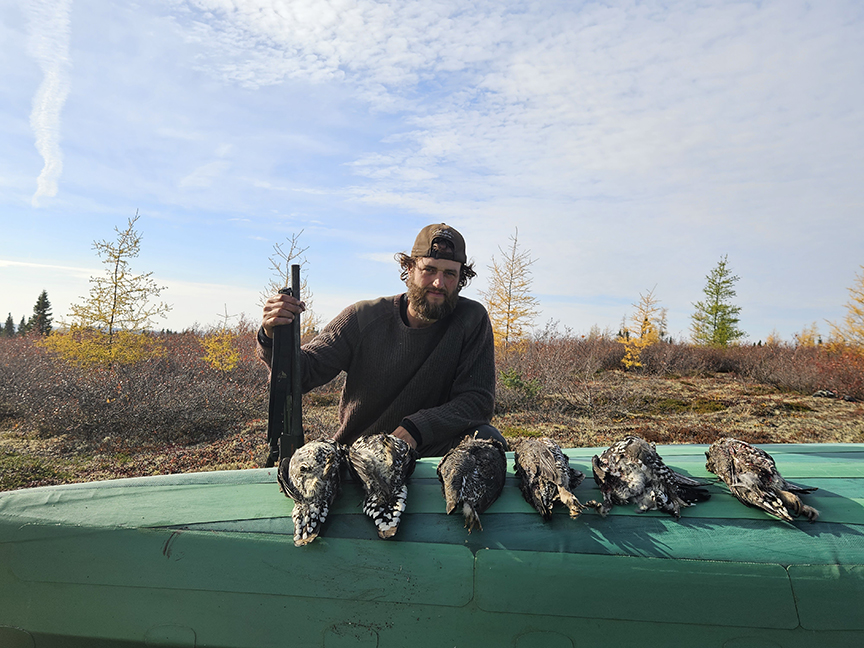
This was by far Barbour's longest trek, but it wasn't his first. In 2017, he trekked across Newfoundland. In 2018, he tried to canoe from east to west across Labrador and northern Quebec -- a shorter version of this trip -- but started too late in the summer and had to bail after 80 days and almost 1,000km when winter set in.
At the time, Barbour was a teacher in Newfoundland, covering grades K to 12. But by 2019, he'd discovered that the YouTube videos of his solo journeys were popular; some garnered millions of views. He also gave presentations and secured sponsorships. Now, this is what he does.
He has only "loose thoughts " about what's next. Maybe he'll cross Alaska, but that's a ways off. He plans to spend the next months editing the hundreds of hours of material into coherent stories. 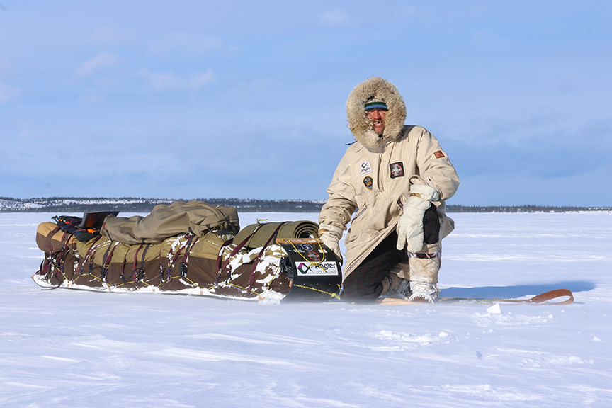
Snorkelers off Australia's Gold Coast had an adrenaline moment they won't soon forget when a humpback whale pitched one of them into the air with a flick of its tail.
Max Persyn and Jacqueline Payne of Queensland were taking part in a swim with whales excursion when one of their guides went airborne. One of the nearby humpbacks had flicked its tail, sending the man skyward.
“We think the rope we were hanging onto touched the whale’s tail, and just like we would flick away an unfamiliar touch, so did the whale," the couple later wrote. "There just happened to be a human above him!”
The whales had been swimming around them for 20 minutes, and by the time of the incident, they had come unusually close.
The guide was unhurt.
Imagine you were guiding a ski trip in Svalbard. One of the participants enjoyed talking about outer space, the Moon, Mars. You figured his interest was intellectual. So many of us drawn to the world's extreme places are also interested in worlds beyond this one. You've probably had many similar conversations before with other clients.
But this client was different. Before Chinese-born Chun Wang entered the ground floor of the bitcoin craze in 2011, when each bitcoin was $5 (it's over $60,000 today), he had volunteered on a computing project to analyze radio signals for signs of extraterrestrial intelligence.
Since then, he's become a billionaire, a Maltese citizen, and part-time Svalbard resident who is still interested in space. Some months after the ski trip ended, he invited guide Eric Philips and one other tour participant -- Rabea Rogge, a robotics PhD student -- onto a private space flight that he had been discussing with SpaceX for a couple of years.
Polar orbit
They will orbit the Earth via the North and South Poles -- something that no crewed mission has ever done. The previous highest-inclination flight by a manned spacecraft was the Soviet Vostok 6 mission in 1963, when cosmonaut Valentina Tereshkova reached 65.1˚, just south of the Arctic Circle.
A fourth person with a Svalbard connection, filmmaker Jannicke Mikkelsen, who lives on the island, rounded out the unlikely four-person crew. No figures have been released about the cost of the flight, but a previous commercial mission through SpaceX was in the neighborhood of $200 million.

Philips is the pilot, while Rogge is the mission specialist. While Mikkelsen officially is the vehicle commander, one of her jobs as a professional cinematographer will surely be documenting the three to five-day flight from her window seat next to one of the portholes. Philips, in front of a touch-screen console, has a middle seat but will still have plenty of opportunity to look outside through the glass nose cone, or cupola, that is uncovered once the Crew Dragon is in space.

Training
Since the announcement two weeks ago, Philips and the others have been training at SpaceX headquarters in southern California. He couldn't say exactly what the training consisted of, but on X, Chun added some details:
"I was once told that the Dragon [space capsule] is fully automatic, and all you needed to know is how to put out a fire," he wrote. "[But] not only do you need to understand every detail of the spacecraft and countless procedures, you must also learn how to administer injections and even perform urinary catheterization in a weightless environment."
Philips said they had also been in a centrifuge, which mimics the G-forces they will be subjected to when they launch from Cape Canaveral at the end of this year.
Last month, before the official announcement, they also spent a week sea kayaking in Alaska's Prince William Sound to see how the members performed in an extreme environment.
Fram2
The mission, dubbed Fram2 in honor of the great Norwegian polar vessel that carried Nansen, Sverdrup, and Amundsen, will launch at the end of this year. At that time, the Arctic will be in the grip of the polar night, and the astronauts will not see much from their perch 420 to 450km up except the twinkling lights of villages far below. But Antarctica will be in full view, a prospect which excites Philips. He has done four new routes or variations to the South Pole during his long career as a polar guide.
"One reason we prioritized Antarctica over the Arctic is that Antarctica is dry and generally has far fewer clouds," explained Chun on X.
For Philips, 62, this golden opportunity comes as his own polar career is winding down. His daughter has begun to take over guiding duties.
"It feels like it's time for a shift," says Philips. "I feel completely out of my depth here. It feels incredibly refreshing."
Canadian kayakers Simon Carrier and Maxime Geoffroy had a good run of it, but they've ended their attempt to paddle the Northwest Passage from west to east.
They are currently on the west side of King William Island and are now backtracking to finish in Gjoa Haven, the island's one community.
They decided to end their 3,000km expedition this week after a little more than halfway. Thick sea ice has blocked their progress around the northern tip of King William Island. Further ice awaits them in Peel Sound before they can transit Bellot Strait to the eastern High Arctic and clear waters.

Since beginning their journey in mid-July, the pair has typically averaged over 40km per day. But even if the ice clears in a week or so, the delay would force them to paddle deeper into the stormy fall. Their final 1,000km would include several big open-water crossings, including 80km from Somerset Island to Baffin Island. At this time of year, night has returned, and they would not be able to enjoy the advantage of constant daylight on these marathon crossings.
Still not easy
Climate change has made the Northwest Passage easier than it was in John Franklin's day, when sea ice often locked ships in place for years, with fatal results. But some summers, ice can still throw a wrench into mariners' plans. In 1846, Franklin's ships themselves became trapped in the ice at the northern tip of King William Island. All died.
The kayakers could have chosen to go around the south coast of King William Island -- the standard route through the Northwest Passage. But if ice conditions are good, the northern route saves many kilometers. Last year, the Arctic Cowboys took advantage of a good ice year to transit the entire Passage from east to west, including an ice-free route around northern King William Island.
Even if Carrier and Geoffroy had taken the southern route, the passage through Bellot Strait remains ice-choked for the moment. Several small yachts are currently anchored in eastern Bellot Strait, waiting for the ice to clear before they can continue west.
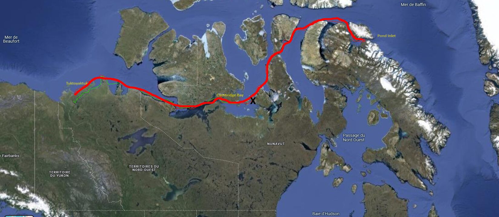
A strong geomagnetic storm over the weekend allowed skygazers as far south as southern California to view the northern lights. But seeing them from the International Space Station 412 kilometers up is an even rarer experience. You're looking down on what seems to be a thin, shimmering green blanket wrapped over the curvature of the Earth.
Matthew Dominick of NASA's space-eye view reminds us that no matter how high the northern lights are, some things are even higher.
The green light that dominates the video appears when particles excited by the solar storms interact with oxygen at altitudes of 120 to 180 kilometers. Below 100 kilometers, particles stimulate nitrogen atoms to create the pink glow visible on the left-hand side of the video. Some even stronger reds begin to appear at altitudes above 200 kilometers.
The ISS is farther above those lights than the lights are above us.
On Thursday, August 8, two polar bears killed an employee at a remote radar station off the coast of Baffin Island in Arctic Canada.
The incident took place on uninhabited Brevoort Island. The radar station is part of Canada and the U.S.’s North Warning System, which is operated by the North American Aerospace Defense Command.
The Nasittuq Corporation, which maintains the stations, has not released many details, including the name of the deceased. It did say that one of the bears was later killed.
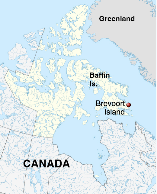
At permanent arctic camps, such as mining operations, an armed polar bear monitor from one of the nearby communities is always on watch. But Nasittuq typically maintains these automated stations seasonally, for just a few days at a time. Some years ago, when I accompanied Nasittuq workers to another North Warning station, we did not have a bear monitor with us. But employees never ventured away from the buildings, except in a vehicle.
Polar bears tend to be solitary, but young polar bears who have recently left their mothers will hang together for a while. In 1983, two starving three-year-old polar bears attacked oil workers in the Beaufort Sea. One killed the foreman of a seismic camp; the other climbed aboard a crew barge and killed an 18-year-old driller. The Royal Canadian Mounted Police later shot both bears.
There are 20,000 to 25,000 polar bears worldwide. Two-thirds of them live in Arctic Canada.
Like a canoe caught indefinitely in a recirculating wave, the world's largest iceberg has been spinning in place for months off the coast of Antarctica -- and may continue to do so for years.
Known as A23a, it is the offshoot of an even bigger iceberg that broke off from Antarctica's Filchner Ice Shelf in 1986. A23a grounded later that year, as icebergs can in shallow water, and remained in place in the Weddell Sea until 2020 when it broke free. It drifted around until December 2023, when it moved away from Antarctica. At this point, the current carries most icebergs into a slightly warmer sea "soup" toward the island of South Georgia, where they slowly melt.

Refuses to die
But A23a became trapped in a vortex called a Taylor column, which forms over sea mountains. Here, the water rotates counterclockwise, like a slow-motion whirlpool.
It's been rotating excruciatingly slowly for the past four months, about 15˚ a day. Since its entrapment, it's performed about five full rotations. Scientists aren't sure how much longer it will continue to do so before the vortex spits it out. It could be months or even years.
"A23a is the iceberg that just refuses to die," polar expert Mark Brandon of the Open University told the BBC.

A tabular or flat-topped iceberg, A23a has an area of 4,250 square km, slightly larger than Rhode Island -- a state that seems to exist mainly to serve as a size comparison. Its parent berg was initially home to a Soviet research station during the dying days of the USSR. When it broke off from the ice shelf, the researchers hastily fled.
It is unclear how often one of these vortices catches an iceberg as it drifts by, but A23a is not the first. In 2020, another giant berg was snared a little west of A23a's position, according to The New York Times. It spun in place for months but eventually drifted off to melt away.
A group of Michigan archaeologists working in Turkey found more than they bargained for when they unearthed an ancient trove of gold coins.
The coins had been hidden beneath a house in the former city of Notion, now in western Turkey, since the 5th century B.C. Each gold coin, called a daric, showed the figure of a crouching archer. At the time, the Persian Empire typically used darics to pay mercenaries for their services. According to the Greek historian Xenophon, each daric was a month's pay for a soldier of fortune.
“The discovery of such a valuable find in a controlled archaeological excavation is very rare,” Christopher Ratte, a professor at the University of Michigan and director of the Notion Archaeological Survey, explained. “No one ever buries a hoard of coins, especially precious metal coins, without intending to retrieve it. So only the gravest misfortune can explain the preservation of such a treasure.”
The researchers had no explanation for how the coins came to be left by their original owner.
When the coins were in circulation, the Greek city-state of Notion was part of the Persian Empire. Conflicts within the city-state and with neighboring states at that time prompted the common use of mercenaries.
Ischii Sports has announced on its website that it has called off any potential rescue of Kazuya Hiraide and Kenro Nakajima.
The celebrated alpinists fell from 7,000m on the West Face of K2 on Saturday. A rescue helicopter spotted their two motionless bodies in the snow on Sunday but could not land. Yesterday, as their film crew moved down to Base Camp, they reported seeing the bodies, still motionless.
According to the Japan Times, a large crack (or serac?) above the figures threatened to give way and made any potential ground rescue too hazardous. With the permission of their families, the attempt was called off.
The Japanese pair had set out to do a new alpine-style line on K2’s formidable West Face. Kazuya Hiraide has won three Piolets d’Or, including two with Kenro Nakajima. ExplorersWeb highlighted their climbs on Karun Koh in 2022 and Tirich Mir in 2023 as among the best expeditions of the year. As we reported earlier this year, Hiraide said his previous climbs have served to prepare him for the greatest challenge of his career, the West Face of K2.
“I have climbed many mountains, and now I have become afraid of them," said Hiraide in a recent documentary about their ascent of the North Face of Tirich Mir. "They scare me because now I know the danger under my feet."
Polar bears don't often show up in Southern or Western Greenland any more, but this year has been an exception. Only yesterday, two appeared near Nuuk, Greenland's capital. And according to Aleqa Hammond, Greenland's former Prime Minister, that's just been the tip of the, well, iceberg.
"There are bears everywhere in West Greenland this year," she told ExplorersWeb. "Quite a few have been way too close to towns in South Greenland this summer, too. Several polar bears have been shot in Qaqortoq, as the bears were literally in town."
Two polar bears even appeared on the popular 160km Arctic Circle Trail between Kangerlussuaq and Sisimiut. Because bears are rare in that part of the Arctic, hikers and locals don't carry firearms.
Hammond said several hikers have canceled their plans due to the potential bear threat. Commenters on the Arctic Circle Trail's Facebook page have warned that calling for helicopter evacuation when you merely sight a polar bear is likely not covered by your insurance.
East Greenland
East Greenland has been even richer in polar bears. Sixty-eight of them showed up earlier this summer to feast on the same whale carcass. No word on whether Matteo Della Bordella, who is in East Greenland to kayak to a big wall with three partners, has had any run-ins with polar bears.
What has caused this unusual polar bear bounty?
According to Hammond, there is a lot of pack ice this year. It travels down East Greenland and around the southern tip of Greenland and then north again with the current. Hence the bears' presence in Qaqortoq, Nuuq, and elsewhere.
"There are many seals traveling on the ice, too," she says. "It's not been possible to reach South Greenland by boat for several months due to the enormous pack ice season." The polar bears catch a ride down on the ice, following the seals.
Japanese polar adventurer Masatatsu Abe has died. The 41-year-old rickshaw driver and Antarctic sledder succumbed to a brain tumor.
In 2018-19, the ever-smiling Abe reached the South Pole after 55 days and 918km from the Messner Start. Struggling like everyone else with the deep snow of that year, Abe was the last South Pole sledder to finish. He had hoped to go unsupported but reluctantly accepted an airdrop of food to finish.
Then in 2021-22, he tried to retrace a 1911 Japanese expedition led by Nobu Shirase but ran out of time.
He was scheduled to go to Antarctica again last November. But after completing his preparations, he was diagnosed in August with the tumor that killed him a short few months later.
Yesterday, polar guide Eric Larsen returned to Colorado after another disappointing North Pole season. The Barneo ice station near the North Pole was slated to run this year for the first time since 2018.
Larsen was the only Western outfitter willing to risk the uncertainties of the new route through Russia, despite the U.S. State Department's Level 4 Travel Advisory. He had five clients -- two from the U.S., one from Canada, one from Spain, and one from South Africa.
All had signed up and paid years before, when Barneo was a regular and reliable feature of the arctic expedition season. They had opted to wait through years of cancellations -- from politics, COVID, and sanctions -- for another chance.
Four of the five clients were trying to complete something called the Explorers Grand Slam. Despite its alluring name, this somewhat artificial list involves climbing the Seven Summits plus skiing the last degree to the North and South Poles.
In the early days of ExplorersWeb, in the early 2000s, this list -- sometimes called the Adventurers Grand Slam -- required skiing the entire distance to the North and South Poles from land. But the North Pole, in particular, was too difficult and committing for the average, non-elite adventurer.
Last full North Pole Expedition
Larsen and partner Ryan Waters were, in fact, the last people to do a full-length expedition to the North Pole, and that was in 2014. Some unnamed collector then redefined the Grand Slam as merely the last 100km to each Pole. That was a lot easier, and the new definition stuck, even though it made the Slam a lot less grand.
Even that last degree to the North Pole has been almost impossible in recent years. But it looked like the staging camp at Barneo was going to run this year.
Larsen and his small group flew from Istanbul, Turkey to Moscow or Novosibirsk, and from there to Krasnoyarsk, in central Siberia. Here, they waited. Large Russian cargo planes had already dropped the bulldozers and other heavy equipment and workers by parachute down onto the ice floe they had chosen for the Barneo camp. Now, they needed to build a 1,000m airstrip and put the quonset-style shelters and other logistics in place.
Larsen told ExplorersWeb that choosing to ignore the sanctions against Russia had been difficult for him and his clients. In the time since the last successful Barneo season, Larsen had had a close brush with mortality, an advanced form of colorectal cancer that he seems to have shaken off.
"I'm back to 98 percent," he said. Returning to his familiar and beloved Arctic was tempting. "It's the one place where I have a skill set that means something in the world," explained Larsen.
He also felt a responsibility to his long-committed clients. And, he said, "There's a long history of polar explorers working with Russians."
Larsen refers to the late 1980s and early 1990s when cooperative expeditions created "polar bridges" between the West and the then-Soviet Union during the perestroika period of thawing relations. Some would suggest things are different now.
Larsen's group wasn't the only one in Krasnoyarsk. Another dozen clients from India, China, and Europe were being guided directly through the Barneo organization. Toward the end of their stay, the North Pole marathoners began to drift into town. There was talk of another planeload of skiers after theirs.
"Everyone was happy to be there," said Larsen. He pointed out how hospitable the Russian people themselves are, aside from the politics of their leaders. "Everybody was nice," recalled Larsen. "People often stopped us on the street and asked where we were from."
Larsen converted U.S. dollars to roubles on his way to Russia but said that buying roubles directly from a local bank in Krasnoyarsk was no problem.
In the end, as we reported last week, Krasnoyarsk was as far north as they went. The weather over the Arctic Ocean was bad, the runway at Barneo cracked, and there wasn't time to rebuild it. "It definitely would have taken at least a week," said Larsen.
So for the sixth time in a row, the season was ultimately canceled.
Next year?
Would Larsen try again next year?
"It depends whether you ask me or my wife," he said. "I love that environment, but as a business decision, it's not the best idea."
Later, on social media, he added, "Svalbard makes the most sense as a jumping-off point [to Barneo]. For starters, all the polar guides (myself included) have storage units in Longyearbyen full of expedition gear, as does the Barneo team. For clients, it’s an easy-to-reach destination with modern amenities...
"The decision to fly through Russia was not one taken lightly...but without the permits from the Norwegian government to land and refuel, there was no other option."
Larsen has no other arctic tours planned for this spring. "I'm coaching under-12 soccer," he said.
Russia has never been a transparent country. Especially for Westerners, it's always been a riddle inside a mystery inside an enigma. So it's unlikely that we'll ever fully understand what caused the cancellation of the Barneo season yesterday.
Since the early 2000s, the seasonal ice station near the North Pole has been a high-priced staging area for last-degree skiers, polar marathon runners, champagne tourists, and others. But because of COVID and political disputes, it has not operated since 2018.
This year, it was all set to go, although it would route through Russia rather than Svalbard. Then came news of yesterday's cancellation.
Journalist Galya Morrell now lives in New York and Greenland but was born in the Soviet Union and has visited Barneo since it began. Today, she contacted several insiders.
"They say it is all a bit awkward but don't want to be quoted," she says. "But there is something else going on, other than Nature."
Morrell went on:
We hear from the organizers that the runway broke and that there was no time to build a new one. Still, in 2016, the runway broke five times. The season was delayed but went smoothly. This year, the runway did break, but the ice is two meters thick. It should be possible to find other options nearby, as they did in other years.
They say that extreme cold was another challenge in 2024. But in April 2015, the marathoners ran in -41˚C.
There may be other troubles at play that we know little about at this moment.
The biggest lesson of the 2024 North Pole season, which started and ended in Krasnoyarsk, is that we may need some fresh, unorthodox ideas about how to arrange logistics for journeys to the North Pole.
Polar guide Eric Larsen, who yesterday sounded like he had not quite given up hope, today conceded defeat.
Barneo, the camp on the sea ice near the North Pole that was going to operate this spring for the first time since 2018, has been canceled.
Galya Morrell, who wrote recently about Barneo's controversial comeback by routing through Russia, broke the news. "The runway is still not in place, and it's April 11," she told ExplorersWeb.
Polar guide Eric Phillips, who decided not to run tours to Barneo this year because of the uncertainty, confirmed the news. "The ice broke up badly, and there is no time left to rebuild," he said.
Before this last-minute cancelation, Barneo -- a Swiss-owned but Russian-operated camp 100km from the Geographic North Pole -- had planned some big events for its revival year. These included a stratospheric parachute jump from 10,000m above the North Pole.
Later today, guide Eric Larsen -- who was leading a tour to Barneo and is currently in Russia -- wrote a note on Instagram that stopped short of giving up entirely: "We almost left yesterday. So close. But another bad weather forecast and report from near the North Pole grounded our flight. It is what it is. At this point, I’m fairly detached emotionally from the many obstacles in our path."
Cycling and pulling a sled during the worst of the northern Scandinavian winter were a piece of cake for 26-year-old Lorenzo Barone of Italy. But when it came to kayaking 1,000km from Finnsnes to Vardo in northern Norway, the ragged weather and long, frightening open water crossings proved too much.
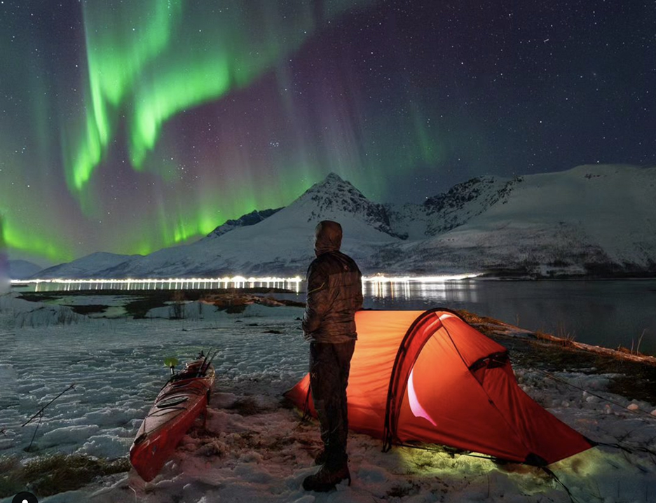
One month after beginning the kayak portion of his winter adventure, he still had almost 500km left. Although spring was approaching, it didn't feel like that in northern Norway. He also broke his rudder near Tromso, and his emergency GPS device hasn't worked for two weeks.
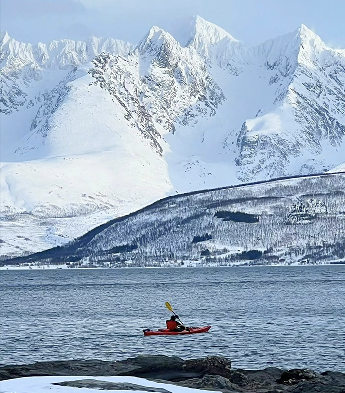
An inexperienced paddler, Barone had tried to avoid an open-water crossing earlier this week by dragging his kayak across a neck of land. Although the experience was better than being out on the water in that gale, it was hardly encouraging, as his Instagram video showed.
Today, he decided to end his journey not in Vardo, but at Norway's North Cape, the northernmost point of Europe. It's only 126km away from his current position. More importantly, it avoids all the big crossings immediately afterward.
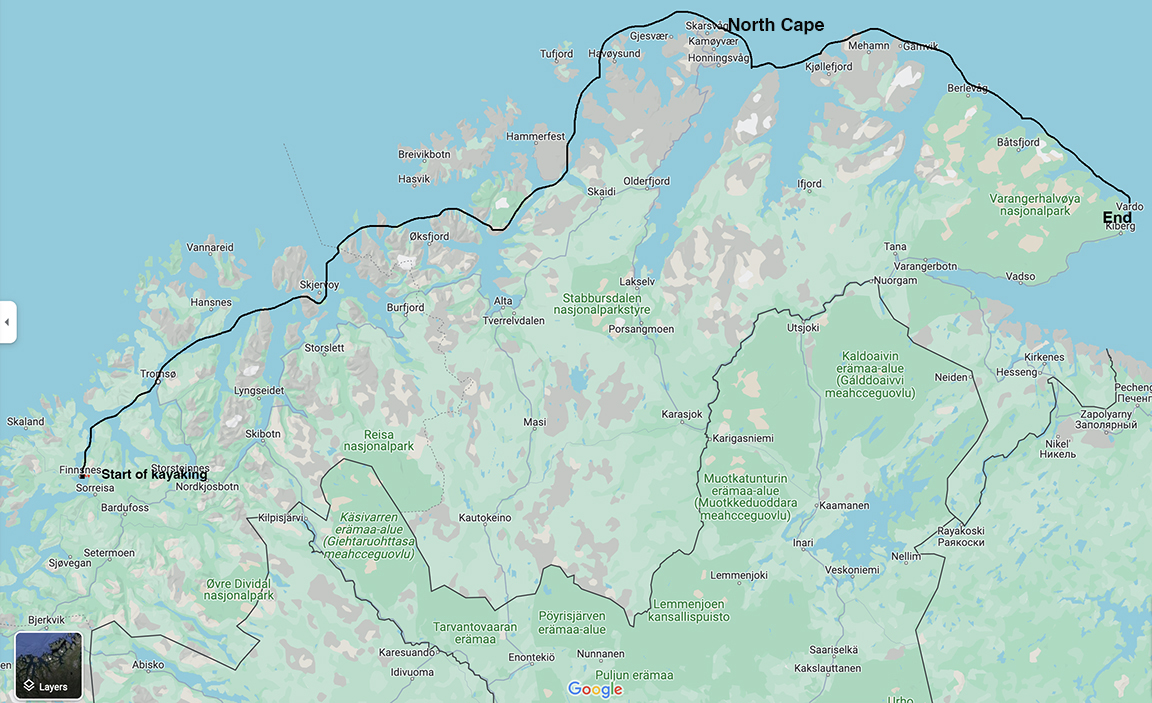
An experienced adventure cyclist, Barone had cycled 1,600km to Sweden earlier in the winter. He then hauled a sled over 600km to Finnsnes, where he began to kayak through the fiords and islands of the north coast.
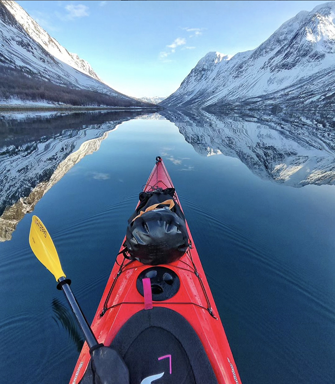
At the darkest time of year, shortly after the winter solstice, 26-year-old Lorenzo Barone of Italy reached the Danish border from Bologna. He had 3,200km cold kilometers ahead of him.

Barone first cycled 1,600km -- "just the approach," he insisted -- to the small town of Hemavan, in Sweden. Here, he swapped his wheels for skis and a sled and manhauled north just over 600km to Finnsnes, on the Norwegian coast. It's been a cold winter in northern Scandinavia, and temperatures en route plummeted to -35˚C.

Today, he began the third leg of his adventure. He plans to kayak 1,000km from Finnsnes to Vardo in northern Norway. Although he paddled 26km today, rare sea ice from the bitter winter added a further obstacle. He will rest and sort out his gear for a few days before taking to the water again.

Barone is an experienced adventure cyclist and says he has cycled 100,000km through various parts of the world. But kayaking is new to him.
At least, the days are noticeably lengthening, he says.

Justin Barbour reached the mostly abandoned mining town of Schefferville this week. The border from Quebec to his home province of Newfoundland-Labrador is just a couple of kilometers south.
Barbour began the most recent stage of his 3,800km overland trek to the island of Newfoundland on Jan. 4, after waiting several weeks for the brooks and rivers to freeze solidly. He started from the red star on the map below.
Schefferville was a booming town during the 1950s and 1960s, during its iron ore heyday. Its latest census in 2021 listed just 244 residents, mostly Innu and some southerners trying to reestablish mining operations.
From here, Barbour will continue south, largely tracking the old iron ore railway line, before turning sharply east. It is unclear how closely he will parallel the Trans-Labrador Highway during this eastward phase.

By mid-February, the sun is strengthening, and the deep cold of late January and early February will soon give way to more springlike temperatures -- springlike for the subarctic, that is. Still lots of -20s. However, the prevailing northwest wind is at his back.

Traditional kit
Rather than travel with modern gear, Barbour has adopted the kit of both the old Labrador trappers and the Innu people of the interior. This includes wooden snowshoes with lampwick bindings, a long, tapered toboggan rather than a Scandinavian-style pulk, a leather pulling strap across his shoulders, no poles, and a canvas tent with a wood stove at night.

He admits that one piece of modern kit has not worked out so well -- an inflatable sleeping pad. The large plastic valves on that style of pad are unsuitable in the cold. Severe contraction makes it hard both to close them in the evening and to open them in the morning to deflate the pad. A simple foam pad or Thermarest-style mattress, with a different style of valve, works better under severe winter conditions.
This part of the interior has patches of trees where he can take shelter at night and find firewood, but is also largely open, with hard, windblown snow that makes this sort of travel easier.
Classic arctic books are rare, but the author of one undisputed masterpiece died earlier this week in Dieppe, France.
Jean Malaurie's The Last Kings of Thule recounted his experiences in Northwest Greenland in the early 1950s. The small, isolated population, which had flirted with extinction for centuries, had recently received another blow when they were relocated from their traditional hunting era to make room for a U.S. military base.
Ethnographer-explorer Knud Rasmussen and his partner Peter Freuchen established a trading post at Thule for local Inuit in the 1920s, but by 1951, the Inuit had been moved further north to make room for a secret nuclear base for aircraft and missiles during the Cold War.

Malaurie, trained as a geographer, lived and traveled by dogteam with the displaced Inuit. In 1955, he published a sympathetic account of his years with these great arctic travelers. It was the first book in a famous series of ethnographic accounts that included Claude Levi Strauss's Tristes Tropiques.

Malaurie's highly readable book about a remarkable people who had only been discovered 100 years earlier made him a preeminent arctic scholar. He became a defender of the rights of arctic minorities in many parts of the circumpolar world.
"I just wish my ashes [to be] scattered over Thule, Greenland," he told a magazine shortly before his 98th birthday.
France's Vincent Colliard has reached the South Pole, breaking the speed record from Hercules Inlet.
Colliard covered the 1,130km in 22 days, 6 hours and 8 minutes. He bested Norwegian Christian Eide's 2011 time of 24 days, 1 hour, and 13 minutes by a little under two days.
Unlike some Antarctic speed records, which may be classified as the least slow in a very limited pool of competitors, Eide's effort has long been considered exceptional. Over the years, others had tried to best it, but conditions had not been favorable.
Colliard averaged just over 50km per day.
After aborting their first attempt at the Northwest Passage in 2022 after just 300km, veteran Texas kayak racers West Hansen, 61, and Jeff Wueste, 63, made some changes: double kayaks instead of singles and two new members -- endurance paddler Eileen Visser of New York and ultramarathoner Mark Agnew of the UK.
The foursome also showed up a month earlier, in early July. A snowmobile from Pond Inlet conveyed them to their starting point at the eastern end of Bylot Island, just north of Baffin Island.

The first two weeks of this 2,500km expedition did not look promising.
That early in the season, the sea ice was still solid along Bylot's south coast, the route they had paddled the previous year. They were kayakers, not arctic travelers, and had little desire to drag their kayaks over the ice to open water. They had not brought either crampons or ski poles to facilitate this sort of travel.
So the Arctic Cowboys, as they styled themselves, sat for nearly two weeks in a little hunting cabin on Bylot Island. If they could only reach the north end of the island, they could begin. There, the strong currents of Lancaster Sound had already cleared away the ice. Once, they made an abortive stab at it, but the swiftly moving floes stymied them. Retreating with difficulty back to the cabin, they waited some more.

Bureaucratic hurdle
Finally, the ice had cleared enough for them to escape. Meanwhile, they and their home team wrestled with local bureaucracy. Part of Bylot Island along that northern route is a migratory bird sanctuary. You can't land there without a permit, which they did not have.
When they finally began to paddle, they took their satellite tracker briefly offline. Perhaps they wanted to avoid leaving evidence that they were landing to camp, contrary to regulations.
"We were not impressed," a Parks Canada warden in Pond Inlet told me when I visited that small arctic town in mid-August.
But after a few surprisingly fast days, the paddlers had moved beyond the forbidden area, and their tracker was back online again.
Thus ended the very messy beginning. For the next two-and-a-half months, Hansen, Wueste, Mark Agnew, and Eileen Visser did almost everything right.
The warden from Pond Inlet did not think they would succeed. I was less sure. It's true that they did not seem prepared to deal with sea ice, apart from waiting it out. But the more that climate change turned the Northwest Passage into a colder version of the Gulf of Mexico, Hansen and Wueste's backyard, the better the chance they had.

Some years still impassible
Some summers, sea ice still blocks the Northwest Passage. In 2018, for example, no vessel made it through. Even large ships had to turn back. Other years, the Passage is wide open.
This was one of those summers. I did the Northwest Passage in late August the easy way, as a resource person on a cruise ship. I've done the Passage in that capacity half a dozen times. This year for the first time, we saw no sea ice whatsoever.
Once the kayakers had escaped the ice of eastern Bylot, they showed how they differed from other parties who had tried the Passage before them. They were very strong paddlers and routinely covered 60 kilometers or more in a day. On their first four days on the water, they did 64km, 56km, 77km, and 71km. During a more modest stretch about two-thirds through the journey, they made 65km, 67km, 38km, 57km, and 48km. The few slightly slower days signified headwinds.
I asked veteran expedition paddler Jon Turk, now 78, about such impressive mileage.
"Modern techniques and fitness are way above what we brought to the sport," reflected Turk. "Also, our boats didn't have the hull speed. Not long ago, I paddled the Arctic in a modern boat. I used to paddle at 2.5 knots. Now I was going 3.5 knots, and I was out of shape. I wondered if my GPS was wrong."
Turk has often dragged his kayak over sea ice, most notably in 2011, when he and Erik Boomer hauled and paddled their boats completely around Ellesmere Island. Turk always used near-indestructible rotomolded kayaks. High-performance boats today are lighter and faster but don't take abrasion well, he explained.
Still, they could have dragged their boats on small custom-made sleds, as I have done with my own fragile kayak on occasion. When not in use, it fits nicely over the aft deck.
Did Turk consider his amphibious arctic journeys, two-thirds hauling a kayak, one-third paddling, an actual kayak expedition?
Turk laughed. "People can call it whatever they want," he said. "I don't give a shit."

Satellite weather reports
Regular satellite weather reports from the Arctic Cowboys' home team allowed them to rest when conditions were likely to turn gnarly. They didn't seem to mind regular two or three-day layovers as the all-too-brief arctic summer yielded to fall. Whenever they were out on the water, their consistent big days allowed them to make up time.
Their biggest day came when they had to cross Prince Regent Inlet from Baffin Island to Somerset Island. Ninety kilometers and some 15 or 16 or 17 hours later, the tired crew beached safely on Somerset. They had other long crossings ahead, but nothing like this one.
A few days later, they transited through narrow Bellot Strait, between the Canadian mainland and Somerset Island. This two-kilometer-wide, 25km-long waterway has such swift currents that you can only paddle it at slack tide or with the tide in your favor. It also marked their passage from the eastern to the western Arctic.

An open polar sea
No sea ice lay ahead of them. In fact, they even chose to paddle down the western side of King William Island. Back in 1846, Sir John Franklin made that same choice, rather than take the safer eastern side. Franklin's ships almost immediately became stuck in the ice. He and all 125 remaining men ultimately perished.
But the kayakers had no problems around King William Island. Maintaining their swift pace, they soon reached the town of Cambridge Bay on neighboring Victoria Island. Here, they rested for a week, picked up fresh supplies, and waited for new drysuits to arrive.
Just one big question remained. As the fall equinox approached and the weather became much colder and more unstable, how would these southern kayakers, inexperienced in the Arctic, handle it? They would have to paddle into October when nights were long, the temperatures remained below freezing, and the snow started to accumulate.

Other parties
This foursome was not the only self-propelled party attempting the Northwest Passage this year. A pair of kayakers in single rowing hulls had started from the west. One became injured and had to drop out, but Matty Clarke persisted alone until eventually, equipment problems forced him to call it quits on King William Island. He ended his attempt at the island's lone town of Gjoa Haven -- named for the Gjoa, the ship Amundsen used for the first transit of the Northwest Passage. It took Amundsen three years.
Another party to attempt the Passage in 2023 was a group of British rowers. Like the Cowboys, they too started at Pond Inlet, but much later in the season. They rowed in shifts, some at the oars, some sleeping in the boat's cabin. They too were making good time. Just west of Cambridge Bay, they were not far behind the kayakers when the cold and storms sapped their motivation. They called it off, seemingly for no particular reason except that they were now uncomfortable with the conditions.

Meanwhile, the kayakers, in much smaller and more delicate craft, continued their intelligent advance. They relied heavily on weather reports from their home team, sat out bad weather, and paddled hard when conditions allowed. The arithmetic made sense: If you can average 60 kilometers a day, you only need to be on the water for 42 days to cover the 2,500km of the Northwest Passage.
Winter closes in
Nevertheless, the last section, from Cambridge Bay to the end of the Northwest Passage, tried their patience. They were tired, and their daily paddling window shrank as the nights lengthened. Early in the trip, you could wait for calm water and launch at 1 am under the midnight sun. Not now.
Their number of tentbound days increased. Once they had to wait five days to paddle three days. Snow began to pile up around their tent. On another occasion, they had to seal launch into five-meter waves. Even at this late stage, not all of them were sure they would make it.
Finally, on October 8, they rounded Cape Bathurst, which marks the end of the Northwest Passage. From here, Amundsen Gulf yawns widely into the Beaufort Sea. No further islands loom to the north of them, and only the Canadian mainland to the south.
They originally planned to finish at Tuktoyaktuk, the nearest town from which their support team could drive them home. Instead, harried now by constant storms, they decided to charter a Twin Otter aircraft to fly them out.

Past attempts
These days, lots of cruise ships and even private sailboats do the Northwest Passage. In spring 2011, Sarah and Eric McNair-Landry kite-skied from Tuktoyaktuk to Pond Inlet, making good use of the prevailing westerlies. A couple of dogsledders, including the great Naomi Uemura, dogsledded the distance. (Uemura actually went from Greenland to Alaska over two seasons.)
In 2013-15, French rower Charles Hedrich rowed from Alaska to Pond Inlet over three summers. But this year marked the first time a party had paddled the entire Passage in a single season. Discounting the McNair-Landrys' wind-assisted journey, it was the first time anyone had done it under their own steam in one year.
Not everyone agrees, of course, that this was the entire Northwest Passage. One reader of our coverage of this expedition, for example, pointed out that by some definitions, the Northwest Passage runs from Davis Strait, off southern Baffin Island, to the Bering Strait.
That seems a little harsh unless you have a sailboat, because no one is going to ski, kite, row, dogsled, or paddle that much greater distance in a single season. The Arctic Cowboys did the obvious Northwest Passage, the familiar Northwest Passage, and it was a singular, hard journey. Faced with alternative definitions of the legendary waterway, the wisest thing for them is probably just to shrug and say, "I don't give a shit."
Editor's note: This story assumed that they resolved their issue with permits for Bylot Island, mentioned above. In the end, they did not, and have been charged with multiple violations. More details in this followup story.
A shaken Colin O'Brady admits, "I almost died today." The American fell into a crevasse just six kilometers from his starting point, on the first day of his expedition.
In an emotional Instagram post, O'Brady recounted how he broke through a snow bridge into a meter-wide hole. Somehow he managed to jam himself between the narrow walls of ice to avoid falling too deeply. Feeling himself slipping deeper, he tried to control his panic.
He managed to remove a ski and let it drop into the bowels of the crevasse.

"It felt like it fell forever," he said.
With a surge of adrenaline, he managed to clamber out. "I lay there on the ice, all alone."
It was nice weather, and he put up his tent and sat inside while two Antarctic Logistics & Expeditions safety personnel snowmobiled out to him. One of them rappelled down into the crevasse and managed to extricate O'Brady's ski and pole from 25 to 30m down.

Try again?
They then drove him back to his starting point, while he considers whether or not to try again.
The American showed up in Antarctica at the last minute, announcing that he wanted to break Christian Eide's 2011 speed record from Hercules Inlet to the South Pole.
Vincent Colliard of France is attempting the same record this year. Currently, after five days, Colliard has covered 164km. At 30km per day, he remains well behind Eide's pace. Eide averaged over 47km per day and completed the 1,130km between Hercules Inlet and the South Pole in 24 days, 1 hour, 13 minutes.
In other Antarctic expedition news, Sam Cox was evacuated off the ice earlier this week with suspected kidney stones. He was trying to ski 2,000km from Berkner Island to the base of the Reedy Glacier via the South Pole.
A Japanese scientist studying thinning sea ice has died when he fell through the ice in Northwest Greenland.
Locals had warned Tetsuhide Yamazaki that ocean currents were fast near Siorapaluk, the world's northernmost village. They said that he should not go this early in the season. Although Yamazaki was experienced, he went. This is the Dark Season in Siorapaluk, and the sun is below the horizon until February, so visibility is poor.

When he didn't return, a search party found a hole where he had fallen through some shuga, or porridge ice, according to ExplorersWeb writer Galya Morrell, who is in touch with the villagers. There was no trace of him.

Despite its remoteness, little Siorapaluk, population about 60, has been a popular destination for Japanese scientists of all stripes for years. That is thanks to the amazing Ikuo Oshima. In 1972, Oshima moved to Siorapaluk from Tokyo after seeing photos of it in a book. He fell in love with the place, married a local woman, and lived the traditional hunting life of that remote Inuit region.

Now a young-looking 76, he is considered the most knowledgeable hunter in the village. His friendliness and willingness to help has drawn other Japanese to Siorapaluk, for briefer periods, to study.

It may not be a "historic feat," as Red Bull tries to sell it, but it's definitely cool to watch extreme kayaker Aniol Serrasolses run a glacial flume, then catapult over a 20m ice wall into the ocean. The action took place last summer on Svalbard, the High Arctic archipelago north of Norway.

The Catalan kayaker and his team trekked 11 kilometers across the Austfonna ice cap to access the meltwater stream. After launching, Serrasolses briefly went through an ice tunnel before it disgorged the kayaker off a 20m waterfall and into the frigid ocean.
Check out the video here.

You can't imagine Amundsen or Shackleton complaining about chafed thighs during a polar trek. But in recent years, Instagram is awash with gory photos showing what Antarctic travelers have had to endure. Victims are often, though not always, women.
In truth, this isn't just chafing. Had the great polar explorers of old had such a terrible affliction, they would have mentioned it somewhere, tough though they were.
What is it? And why the Antarctic, in particular? Lots of people ski across Greenland and elsewhere in the Far North and don't seem troubled by it.
I've done many sledding expeditions in the Arctic and neither I nor my partners have ever had it. Or maybe I've had a mild case without realizing it. For most of those expeditions, I've used synthetic base layers. After merino became popular, I tried it on colder trips, since merino is a little warmer than the same thickness of synthetics. After two or three weeks, a rash began to form on my legs. At this point, I changed to my backup synthetic underwear, and the rash went away. This happened on two expeditions.
I think the first time I saw real polar thigh was when two Australians, James Castrission and Justin Jones (Cas and Jonesy), did a three-month Antarctic trek in 2011-2. They documented it in their entertaining film, Crossing the Ice. One of them developed a gory, raw thigh and showed it in the film.

Merino for three months
They had a merino sponsor, and considering my own small experience with a merino rash, I assumed that this was due to wearing wool underwear for three months. Likely they didn't have synthetic backups or -- as novice polar travelers -- didn't draw the connection between the ailment and their underclothing. Merino is very comfortable, but few people have worn a single piece of long underwear for two or three months, never taking it off, for us to know whether the salt or some bacterial buildup in that natural fiber causes a skin irritation that can worsen into polar thigh.
To better understand, I asked a who's who of polar travelers and guides, including Borge Ousland, Richard Weber, Eric Larsen, Eric Philips, Erik Boomer, and Lars Ebbesen. They didn't all agree, but two theories emerged: that it had something to do with wool and that it was a kind of infected frostbite.

Weber wears only synthetics
Richard Weber is one of the proponents of the wool theory and has long insisted that his clients only wear synthetics. "I believe it is caused by wool underwear that does not breathe properly, in combination with waterproof/breathable wind pants in cold weather," he says. "I suspect it is some bacteria going crazy."
He adds: "I have never had it because I always wore thin synthetic underwear and breathable wind pants. But some Russians got it a bit on Polar Bridge [the 1988 Russian-Canadian expedition across the Arctic Ocean], as they wore very thick wool underwear."
Weber says that on his last South Pole trip, one of his female clients wore wool, against his strict instructions. "She started to get [polar thigh], switched to synthetics, and it went away," he said, echoing my experience.
Larsen: Antarctica both warmer and windier
Eric Larsen agrees with Weber. "I guided my first South Pole trip in 2008 and we were talking about it then," he said. "It’s definitely more of an Antarctic than an Arctic phenomenon. I believe it’s because it’s both warmer and windier in Antarctica."
Larsen believes that wool might be a factor not because of rubbing or chafing but because wool doesn't wick moisture away from the skin as synthetics do. Like Weber, Larsen always wears synthetic base layers and has never had the condition.
"In my opinion," adds Larsen, "the mechanism of polar thigh is that your thighs get too cold, but without a lot of nerves, you don’t feel it much. [Then you] get some sort of cold damage. This is exacerbated if the skin is wet from bad moisture management. As that skin becomes damaged, it itches, you scratch it, it gets infected, it’s not clean, it gets cold damaged again, you sweat too much…"
"This happens in Antarctica more because it’s so much windier and you’re basically skiing into a headwind all the time. It’s also warm, and people don’t do a good enough job with ventilation."
Extra weight
Eric Philips thinks that merino may contribute to polar thigh but admits that he isn't sure. "I have had clients with polar thigh, and my daughter gets it," says Philips. "It seems to be more prevalent in women and people with a higher proportion of fat.”
Philips recalls that Jon Muir, one of his partners on a 1998 South Pole expedition, had a mild case of it. "Jon was definitely wearing wool," he said.

Note that some travelers doing extremely long polar treks, including the Australians Cas and Jonesy, pack on a dozen kilos or more before their expedition, to minimize the amount of food they need to carry in their sleds. So even people who are usually thin sometimes start their expeditions with significantly higher amounts of fat than they are used to.
Borge Ousland had polar thigh himself on an early expedition, his 1995 South Pole trek.
"It was probably caused by chafing that got infected," Ousland told ExplorersWeb. "But I think in most cases, it starts off with a frostbite that turns into a wound and eventually gets infected. When I started using longer and more insulated underwear, and was careful to avoid chafing seams, I have not had it.
"My theory is that the thighs are well insulated with fat and few blood vessels to keep the skin warm, and it's easy to get small local frostbites there."

Better parka design
Women have more fat on their legs, so may be more vulnerable, he suggests. Ousland's custom-designed Norrona shell is much longer than most models, further protecting the thighs from wind and cold. Roland Krueger, the first German to go solo to the South Pole, likewise lengthened his jacket by sewing extra fabric onto it.

Lars Ebbesen, the manager for Ousland's polar outfitting company, is very familiar with polar thigh.
"It is frostbite, pure and simple," Ebbesen insists. "It shows up on the legs in places where circulation/protection is scarce. Like the inside."
He admits that it looks like an ordinary red rash at first, but it is almost always the beginning of frostbite.
"And this is very often where it goes wrong," he warns. "If you do not take immediate precautions, and just think cleaning/treating the rash is the way to go, you lose very valuable time in stopping the frost injury. It gets a foothold, and there is no way back."
He says that at the first sign of a rash, the traveler must immediately protect the area, adding insulation or even wearing down pants. If you let it advance too far, it can become an open wound.

Advanced polar thigh won't heal in the cold
"If it gets that far, it is extremely difficult to heal in the cold," says Ebbesen. "It usually keeps growing. Even though places like Antarctica are the most pristine and cleanest in the world, you risk getting infected. So bringing antibiotics can be life-saving."
Given the potential for delays in rescue, the condition -- if advanced enough that the infection gets into the bloodstream -- can be fatal, he says. It is even dangerous after an expedition ends and the traveler is reintroduced to a warm environment. Circulation improves, and the infection can spread quickly.
To prevent polar thigh, "we at Ousland Explorers will not let anybody on the ice without PrimaLoft shorts or pants," says Ebbesen. He points out that many polar travelers, men and women, wear down skirts these days to protect their thighs. Norwegians, he says, often wear an extra layer of Brynje, or mesh underwear, beneath their longjohns to trap air and increase warmth, yet allow moisture to wick away.
Eric Larsen agrees with that precaution: "I also wear long underwear ‘cut-offs’ -- an extra pair of light long underwear cut off at the knees," he says.
Harder for those who sweat a lot
Another important consideration: We all respond differently to cold. At -35˚C, my wife's face actually hurts, while mine is perfectly comfortable. (A main reason why we've done many kayaking and backpacking expeditions together but never a sledding trek.) I perspire hardly at all while pulling a sled, while some partners are drenched in sweat. People who sweat heavily are always on the razor's edge between freezing and sweltering. Others have a wide margin of equilibrium between the two extremes.
"Sweaters" need to be much more diligent with self-care. Bottom layers take much longer to swap out or layer than top layers, because you have to remove and replace boots and skis. I almost never change bottom layers during the day -- it doesn't matter if I'm a little warm down there, because I don't sweat much -- whereas I sometimes tweak top layers, headwear, and gloves several times an hour.
Erik Boomer admits that he's a heavy sweater.
"I really need to vent and swap layers a lot," says Boomer. "I get cold knees, thighs, and parts of my chest and need to keep an eye on those areas, especially on cold windy days."
When he first did winter treks on Baffin Island, he didn't wear enough layers on his legs.
A close call
"I got by well, but one very cold evening, I felt the beginnings of polar thigh," he recalled. "It just felt warm and like windburn. I’m sure if I kept exposing my thighs to that, it would have developed. Now I put on puffy pants more often and wear more layers in general."
He believes that people are moving faster these days and wearing fewer layers, and that is something to be aware of. "Even if hands and feet and nose are good, you can still get cold thighs."

Whether due to wool, sweating, infected frostbite, or some medical condition such as cold panniculitis, polar thigh seems at least easy to circumvent:
- Although not everyone believes that wool is a contributing cause, synthetics work, so if you want to be safe, wear synthetic underwear. Or at least, have it as a backup, so you can change into it at the first sign of a rash.
- To counter the unique combination of summer warmth and icy wind in Antarctica, wear a down or synthetic skirt or an extra pair of knee-length mesh underwear.
- At the first sign of a rash, do something -- better moisture management, warmer leg layers, a change of clothing -- before it worsens to the point where it becomes infected. In the polar regions, some things you just tough out, but this is not one of them.
A regional -- read: very regional -- Canadian television show called Land & Sea has been airing since the 1960s. It presents half-hour vignettes of life in Newfoundland and Labrador, a rugged province on the country's east coast.
Newfoundlanders have always had to be tough and resourceful. Their Irish heritage and hardscrabble seafaring tradition give them a different style from people in other parts of the country. (Newfoundland only joined Canada in 1949.) You can see this unique character at play in Land & Sea, now that the episodes are available on YouTube.
This sample 1980 episode goes off the island of Newfoundland to the wild northern coast of Labrador, the mainland part of the province. It kicks off with a tribute to an Inuit man, previously featured on the program, who died in a blizzard earlier that year. Two other men also perished in the storm.
A late friend of mine, Auggie Anderson, was one of the survivors of that blizzard and used to tell me about it. They were out caribou hunting on snowmobiles on the open tundra above the town of Nain, in northern Labrador, where they all lived.
"We saw it coming but there was no time to do anything," Auggie explained. "It hit us like a wall."

Hunting easier nowadays
The three men who died succumbed to the cold almost immediately. Others survived, some by hunkering down in a shelter. Meanwhile, Auggie trekked for days to the coast to look for help and eventually found it.
Caribou hunting is easier for Inuit in modern times than it used to be. They have rifles and snowmobiles, although the snowmobiles in 1980 were not as reliable as they are today. Everyone had to know how to repair one themselves in the field. No one traveled alone; you needed a buddy in case your machine broke down irreparably. Satellite phones didn't exist then.
At the time, Labrador's George River caribou herd was the largest in the world, numbering about 800,000 animals. Hunting was good. But you often had to go up on the exposed tableland, where the caribou spent the late winter. There is no shelter there from storms.
Once, Auggie took me caribou hunting with him and his friends. I rode the komatik, or wooden supply sled, dragged behind the snowmobile. It was a rough ride over the hard, bumpy snow at 40 or 50kph. Sometimes, the komatik was airborne as I clung on desperately.
We drove 150km, then Auggie shot a caribou. We loaded it on the komatik and drove the 150km back to Nain. I sat on the dead caribou, which gave me more padding. Nevertheless, by the time we arrived, I was so beaten up that I felt I'd just gone 12 rounds with the heavyweight champion, who'd kicked me in the behind several hundred times for good measure.
Caribou populations are cyclical. Shortly after their 1980s peak, the numbers crashed. Why? Too many caribou for the meager arctic fare, disease, and a healthy population of wolves that grew in response to the earlier bounty of caribou.

Few caribou these days
By 2012, there were 27,000 caribou left. By 2017, only 9,000. Then numbers dropped even lower. The Inuit of northern Labrador have voluntarily refrained from hunting them to give the herd a chance to recover. The George River herd has not yet begun to bounce back but is still hanging on.
Times have changed since the film, but Inuit still travel out on the land in harsh weather, to hunt seals and cut timber to bring home for firewood.
Once, Auggie got himself a fancy new snowmobile. The machines only lasted a couple of years in that rough, frigid environment, so new purchases were common. He was taking it for a test spin on the sea ice near town. He hit a bump, fell off, hit his head, and died.
I've kept in touch with his widow Rita, but I still miss my old friend. When I was planning my first expedition, he gave me some valuable survival advice while telling me the story of his own survival during that blizzard.
This little film captures the mood of an Inuit caribou hunt pretty well, minus the idiotic white guy clinging to the komatik for dear life.
Kamchatka's ever-restless Klyuchevskaya volcano has erupted again. This time, the 4,754m snow-capped giant sent a plume of ash 12 kilometers high. The ash column also extended 1,600 kilometers away, interfering with overseas flights.
Klyuchevskaya is one of the Siberian peninsula's 300 volcanoes and is almost perennially active. It has erupted over 100 times in the modern era, most recently in 2007, 2010, 2012, 2013, 2015, 2019, 2022, and earlier in 2023.
During its few quiet periods, mountaineers have set out to climb it since its first ascent by Britain's Daniel Gauss and two partners in 1788. Last year, a party of nine Russian climbers died on its slopes, from a fall and exposure.
The Polar Record, the journal of Arctic and Antarctic research from Cambridge University, has made all its latest articles going forward free to read online.
While the long-standing academic publication features many articles of limited interest to non-specialists, each issue typically includes the latest research about explorers that is of interest to anyone smitten by polar history.
Until now, you needed to access Polar Record articles through a university library, have academic credentials, or pay a steep fee for an individual subscription.
Established in 1931, the quarterly journal is managed by Cambridge's Scott Polar Research Institute. It is widely considered the world's best English-language polar journal.
Older articles remain behind a paywall at a cost of $26 each.
The four Northwest Passage kayakers who style themselves The Arctic Cowboys have successfully finished their attempt to paddle the entire arctic throughway in a single season.
Yesterday, West Hansen, Jeff Wueste, Mark Agnew, and Eileen Visser rounded Cape Bathurst, which marks the western end of the fabled passage. From here, the channel opens up into the wide Beaufort Sea.
That last 26km was not easy. Their home team reported:
The team experienced the roughest waves of the entire expedition...They seal-launched from Whale Cliffs in 15-foot waves, some going over West’s head with 20-foot breakers at the turn. Once past Cape Bathurst, they paddled into the mud flats. West and Mark had to get out of the kayaks and pull them through ankle-deep freezing water and mud 200 yards back into Snowgoose Channel. Jeff and Eileen got out when they hit mud, to help. Jeff’s boot got sucked off and he ended up in the muck. It wasn’t for the faint of heart.
Winter has already set in, and temperatures now remain below or around freezing, even during the day.
The journey is not quite over. They still have to either paddle to Tuktoyaktuk (some 225km further) or arrange a pickup en route. But with the primary mission accomplished, the thoughts of real food again should help warm them in the remaining days ahead. Leader West Hansen has lost 14kg during the three-month journey.

Two other parties attempted the Northwest Passage this season. A party of British rowers, also rowing from east to west, quit near Cambridge Bay. And a solitary kayaker, going west to east, had to stop near Gjoa Haven, a little less than halfway, overwhelmed by repair issues.
After almost three months and 2,400km, the four kayakers are currently halfway across their last big crossing. It will be a 54km day, to the peninsula that ends in Cape Bathurst, the terminus of the Northwest Passage.
From here, they may paddle a little further to Tuktoyaktuk, their original endpoint, or stop early, if they can catch a ride. Either way, they will have successfully kayaked the Northwest Passage in a single season for the first time.
Their finish is none too soon. Snow is on the ground, and daytime temperatures for their crossing have remained below zero. It's currently -3˚C. Early winter has arrived. It's been particularly unseasonal for the two Texans in the group, West Hansen and Jeff Wueste.
Of the other two, Mark Agnew is from the UK, while Eileen Visser lives in New York State.
The foursome had to wait several days at their last campsite for the winds and waves to die down enough to attempt this last big haul.
Update: At about 9 pm ET on Friday, they finished the crossing.

More information has emerged about the two campers killed by a grizzly in Banff National Park last Friday.
Doug Inglis, 62, and Jenny Gusse, 62, died on day 5 of a week-long backcountry trip in a remote area of the park northeast of Lake Louise, according to Doug Inglis's uncle, Colin Inglis.
Colin Inglis told the CBC that he had been receiving daily reports from the couple's Garmin InReach. That day, he received a message that the pair hadn't reached their planned destination, but they were fine and were setting up camp.
But later that evening, he received a second, more dire message that said, "bear attack bad."
Parks Canada officials told him that the two were attacked in their tent, along with their seven-year-old border collie, which also died in the attack.
“Their tent was crushed and their e-readers were open, they were both discovered in their stocking feet," Colin Inglis told The National Post.
The couple had been together since university and went camping at least twice a year, often while canoeing. Doug Inglis was a scientist and his wife Jenny was head technician in the same lab. They lived in Lethbridge, Alberta, 200 kilometers south of Calgary.
Parks Canada said that one of the two cans of bear spray had been deployed. The other had not. With such experienced outdoor people, it was a case of the "wrong place at the wrong time," Inglis said. "This bear was not to be deterred.”
Bear attacks are rare and even more rarely fatal. This was the first fatal grizzly attack in Banff National Park in decades, park officials said.
There has been an update about the grizzly attack in Canada's Banff National Park that left two people dead last Friday.
In the fatal incident, a husband and wife and their dog perished. Around 8 pm on Friday evening, one of the couple was able to send a satellite message indicating a bear incident. The device also gave their coordinates. Parks officials trekked in during poor weather and reached the site at about 1 am. They found an aggressive grizzly on the scene, which they shot.
The autopsy revealed that it was an older, female bear that had less fat than normal for this time of year. The deceased couple did have two cans of bear spray with them and had hung their food properly. This confirms that they were already in camp -- unsurprising, considering that it was near-dark by 8 pm.
We don't know if either had managed to deploy the bear spray. At least one of the victims had had time to send the GPS message.
It is also unclear whether their dog had been on a leash before the incident. The couple had the proper backcountry camping permits.
Parks Canada did not say whether there was a carcass nearby. But the 25-year-old non-lactating female did not have cubs that she was defending.
"The bear was not collared or tagged and was not previously known to Parks Canada staff," the organization said on Tuesday.
Parks Canada says it's impossible to know what exactly happened leading up to the attack and it did not care to speculate, according to CTV News.
The area of the attack, in the remote Red Deer River Valley north of Lake Louise, remains closed.
A grizzly has killed a husband and wife in a remote corner of Canada's Banff National Park. The two were experienced backpackers, a family friend told the media. The couple's dog also died in the attack.
The incident occurred Friday evening around 8 pm in the Red Deer River Valley. This is an isolated part of the park with trails but no nearby roads. Banff wardens received a GPS alert indicating a bear attack.
When the response team reached the site at 1 am, they found the two dead campers and an aggressive grizzly nearby, according to the Cochranenow newspaper. Park officials shot the grizzly and later, closed the area within the black square, below.

At this time of year, grizzlies are feeding heavily, in order to put on fat for the winter. It is also a popular hiking time across the Rockies, with cooler temperatures and the bright golden colors of larch and aspen. Several recent incidents with bears have taken place elsewhere in the Canadian Rockies.
There were 26 bear attacks in Canada in 2022, including four fatalities.

Okay, maybe it's an exaggeration to call 500km the home stretch, but after 2,050km, it must feel that way for kayakers West Hansen, Jeff Wueste, Mark Agnew, and Eileen Visser.
Today, they passed a major milestone, crossing from Canada's Nunavut territory -- where they've been the entire time -- into the Northwest Territories. They're skirting along the mainland. No major crossings between islands left.
True, winter is closing in fast. Temperatures in the ever-shrinking daylight rarely top 5˚C; nights dip to 0˚ or a little colder. They've had to contend with increasing winds and big swells in the unstable September weather.
They've been good at when to wait for better weather and when to push. On those days when they can move, they continue to put in mega-distances. Sixty-five kilometers is typical. At that rate, they will eat up the remaining distance to their endpoint at Tuktoyaktuk well before winter begins in earnest.
Last month, I visited Beechey Island in the Canadian High Arctic for the umpteenth time. Barren and hostile, Beechey is nevertheless the most visited historic site in the Arctic. Twin Otter airplanes from the nearby hamlet of Resolute Bay have landed on the flat beach with day visitors for decades. And every arctic cruise ship, a couple of dozen of them each summer, stops here.
Why the interest? Because Sir John Franklin and his men spent their first winter in this sheltered harbor in 1845-46, before heading further west in search of the Northwest Passage, ultimately to their doom.
Three of Franklin's men didn't even make it through that first winter. They died of tuberculosis or pneumonia and were buried on the gravel beach. A few years later, one of the sailors searching for Franklin also died here and was buried beside them. The original wooden grave markers were taken to a museum, but replica markers indicate who is buried in which grave.
Oddly, though, there seems to be a fifth, unmarked grave beside the original four. Visitors are always curious. Who is that?
It turns out that these are the remains of a wealthy individual who at least 50 years ago, decided to have himself buried at this historic site, beside Franklin's men. There was no law against it then, and there seems to be no law against it now. Why have yourself buried in an ordinary graveyard when you can achieve a measure of posthumous notoriety by making yourself part of a story that you have nothing to do with?


Graffiti Row
Beechey is a haunted, fascinating spot, but it is also a mess of such vanity gestures. Two other people, a territorial administrator and a scientist, are buried a little further down the beach. They lie just above the ruins of Northumberland House, built in 1852-3 by one of the parties searching for Franklin. They are in what I like to call Graffiti Row.


Some are legitimate memorials from that era. A cenotaph stands in honor of explorer Joseph-Rene Bellot, who died nearby. Lady Franklin herself provided the marble slab underneath the cenotaph, and the cross is built of discarded cans from the Franklin expedition. Behind the cenotaph, Captain Joseph-Elzear Bernier etched his name on a piece of wood in 1906, during his project to assert Canadian sovereignty across the arctic islands.

'I was here'
Other cairns and memorials are totally irrelevant. Europeans transiting the Northwest Passage in sailboats, in particular, seem to behave toward the Arctic as if it's still the nineteenth century. A Hungarian family that sailed the Northwest Passage eight years ago left their name bolted to a rock beside a cairn. Several "time capsules" also litter the ground around the cairn.
Just up from the graves, some modern French yachties built a second cairn and laid a plaque to Bellot. Typically, the plaque included their own names in bronze. Because that's the point: On the pretext of commemorating some valid past explorer, they're really commemorating themselves. "I was here."


Vanity plaques at other sites
Beechey is not the only place that suffers from this sort of graffiti. Norwegians are amazing arctic explorers who have accomplished some of the most difficult polar journeys of modern times. But this was not one of them: In 1992, a Norwegian hired Inuit guides to snowmobile him hundreds of kilometers on Ellesmere Island. He came from the same hometown as Otto Sverdrup -- Steinkjer. Sverdrup's presence dominates Ellesmere, and at key Sverdrup sites, the Norwegian tourist bolted elaborate plaques on boulders, commemorating Sverdrup and himself in equal point size.

I've unbolted one of these plaques and thrown it in the ocean. Another now serves as a hot plate stand in my kitchen. More remain out there. They'll last 1,000 years, or 10,000 years, in that environment. It is important to get to them in time because after 50 years, they themselves technically become artifacts and should not be touched.
Even this summer, adventurers continued this practice. The UK rowers who had attempted the Northwest Passage stopped for a couple of days at the historic Hudson Bay post at Fort Ross, at the eastern mouth of Bellot Strait. They shouldn't even have been there; you need a permit to land at Fort Ross, and none were being granted this summer. It's likely that they didn't know permission was necessary. But they too left a plaque behind, largely celebrating themselves. "We were here."

Back in the 1970s, when those people had themselves buried on Beechey Island, these gestures were partly understandable. It was a different era. At that time, even scientists sometimes took artifacts home as souvenirs. That is obviously not acceptable today. Nor should commemorating your own minor journeys with long-lasting plaques, even if you're doing so partly to pay tribute to a hero of yours. In most ways, the Arctic remains as wild as it was in the nineteenth century. But this is not the nineteenth century.
For weeks, Matty Clarke wrestled adversity in his attempt to row the Northwest Passage. First, his partner Adam Riley injured himself and had to withdraw. His daggerboard broke twice. Recently, as high waves slapped his boat repeatedly on the water, a seam on his boat cracked, letting in water.
Now his electrical system has given up the ghost, and that has prompted him to call it quits. He is currently about a little more than halfway to Pond Inlet, the eastern terminus of the Passage. He has just rounded the northern tip of King William Island, where Sir John Franklin's two ships came to grief in 1846. His plan is to work his way 200km down to the Inuit town of Gjoa Haven. There, he will end.
Without an electricital system, his bilge pumps won't work and he can't recharge his communication devices. Although he has a backup solar panel, the low autumn sun isn't strong enough to charge adequately, according to Riley, who is now helping with logistics.

Last week, a four-person UK team trying to row the Northwest Passage from east to west chose not to continue in the rough fall weather.
This leaves only the four kayakers in the Northwest Passage. They have waited out the recent windy weather and have now reached the mainland west of Victoria Island.
The four kayakers who are attempting to do the entire 3,000km Northwest Passage recently took a week off in the town of Cambridge Bay to rest and resupply. That included getting new, non-leaky drysuits for their final section.
They are currently skirting the south end of Victoria Island and will then make a short hop to the Canadian mainland. From here, they will follow the coast west to their endpoint at Tuktoyaktuk.
West Hansen, Jeff Wueste, Mark Agnew, and Eileen Visser are paddling in two double kayaks. While they've had delays -- most notably, 10 days at the beginning, waiting for open water off Bylot Island -- they've put in consistently big daily distances when the winds have allowed it. Recently, they've covered 65km, 67km, 38km, 57km, and 48km.
Although early winter has arrived in the Arctic -- earlier this week, they reported snow flurries instead of drizzle -- they only less than 1,000km to Tuktoyaktuk. If the fall winds are not too bad, they may be able to finish before the end of the month, when winter really begins to set in.

Engine use nullifies rowers' self-propelled status
Meanwhile, a group who are rowing the same route as the kayakers (but continuing a little further to Alaska) are now approaching Cambridge Bay. Although they began their expedition much later, rowing is faster than kayaking, and they may overtake the kayakers before Tuktoyaktuk.
However, just before Bellot Strait the rowers used their boat's electric motor to dislodge themselves from a sand bank on which they unexpectedly ran aground. (Soundings are few and not always reliable in the Arctic.) Minor though this engine use was, it does put an asterisk beside their self-propelled transit -- just as an 8,000m climber who takes a few puffs on an oxygen bottle can no longer claim a no-O2 ascent.

A third party, solo rower Matty Clarke, continues efficiently in the opposite direction, from Tuktoyaktuk to Pond Inlet. He is currently east of Cambridge Bay and approaching King William Island. Clarke currently has farther to go than the other two groups but has been doing well alone since his partner became injured and had to quit.

The Northwest Passage has bedeviled arctic explorers for centuries because of short summers and unpredictable sea ice. Most famously, Sir John Franklin and his crew of 128 became bogged down in the ice off Northwestern King William Island in 1846. They abandoned their ships around 1848. Some managed to survive for two or three years after that, but ultimately, all died of starvation and disease.
Sea ice in the modern Northwest Passage can still block ships. In 2018, no ship made it through. Other summers, the ice clears out thoroughly, and 2023 has been one of those years.
The four kayakers (or Matty Clarke, if he puts on a spurt and finishes sooner) could claim the first self-propelled summer traverse of the Passage within a single year. In the spring of 2011, Eric and Sarah McNair-Landry kite-skied from Tuktoyaktuk to Pond Inlet over the sea ice.