The British Antarctic Survey (BAS) has released an interactive map of Antarctica. It combines information on coastlines and contours and is available to everyone from tourists to researchers to the merely curious.
Antarctica is constantly changing due to climate change, and many of its frozen features have become out of date. New data keeps up with these changes, and the frequently updated map reflects the latest details about the White Continent.
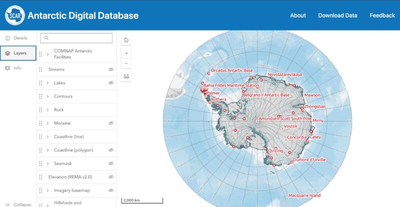
The Mapping and Geographic Information Centre (MAGIC) at BAS maintains the Antarctic Digital Database. The database began in 1993, as a CD-ROM of existing topo maps. The BAS and other research organizations have expanded that information over the decades.
The map shows moraines, outcrops, contours, lakes, streams, and coastlines. Small red dots on the maps highlight an ice formation, land feature, or research base. Clicking on it gives specific information about that particular place, including photos, elevation, and the source (and age) of data.
This release ties in with the map's latest update, which focuses on Antarctica to 60°S. The BAS updates the maps every six months and is reaching out for feedback from anyone who has used them in case inconsistencies exist.
The new map even shows the giant icebergs that have recently separated from the continent, the ice shelves that still grow in some areas, and the changing coastline of the South Orkney Islands. New islands, exposed by retreating glaciers, are added to the map.
The BAS hopes that the maps will help advance polar research. “Free and open access to reliable data is extremely important in all areas of Antarctic work," says mapping specialist Laura Gerrish.
The Barneo ice camp near the North Pole may have been canceled, but three Russians managed to parachute from the stratosphere and land on the sea ice nearby.
The trio parachuted from the stratosphere, which begins about eight kilometers above the surface. They completed the high-altitude jump from 10,500m on April 12 to coincide with the anniversary of Yuri Gagarin's first human space flight.
Mikhail Korniyenko, Denis Efremov, and Alexander Lynnik threw themselves out of the Ilyushin-76 plane. They fell for around two-and-a-half frigid minutes before opening their parachutes. They glided the final 1,000m to the ice below, landing near the Barneo camp.
In freefall, they traveled at over 300kph. Meaning that the already cold, -50˚C air felt more like -70˚C. To combat the incredible cold, all three wore heated masks. Despite this, all now have frostbitten cheeks.
An experienced trio
Lynnik and Korniyenko came up with the idea for the jump. Lynnik is a space technology engineer, while Korniyenko is a cosmonaut who has been on several missions to the International Space Station. Efremov, who works in stratospheric flights, joined the team later.
The three men underwent tests in heat and pressure chambers to prepare for the jump. They even carried out a test jump from 6,000m. They decided against using spacesuits because of the lack of maneuverability. Instead, they wore overalls, goggles, heated gloves, and a heated oxygen mask.
The hour before the jump, they breathed pure oxygen to get all the nitrogen out of their blood, to avoid decompression issues during freefall.
For the Russians, this was not just an attempt to set a world record. They were testing a new communication system.
Testing a cheaper version of Iridium
Before the jump, the communication equipment was parachuted onto the ice from a lower altitude. After landing in Borneo, they used diesel generators to establish a satellite connection.
Speaking to Reuters, organizer Nikita Tsaplin said, “Of course, our solution is a prototype...It's not Iridium just yet.”
The low-cost satellite was launched in June 2023 and flies over the North Pole every half an hour. Now that Kornienko, Efremov, and Lennik have established a connection between the satellite and the server in Barneo, the experiment will continue for the next month.
While the ice floe was not large enough to accommodate the many tourists who wanted to fly to Barneo, the research group will presumably leave on a small plane that needs a shorter ice floe on which to land.
Rudolph is the world's most famous reindeer. His shining red nose is known for helping Santa's reindeer navigate through the starry night sky on Christmas Eve. But as it turns out, the reindeer have such excellent night vision that they never really needed him.
Reindeer eyes do something not seen in any other animal. They change color with the season. Go and look at a reindeer in summer and you will see a pair of golden brown eyes staring back at you. In winter, they change to blue. The surface of their eyes, the tapetum lucidum, is a light-enhancing tissue. It is this that changes color.
This color change allows them to do two things: see better through heavy snow and perceive ultraviolet light. For years, researchers have wondered why reindeer eyes have evolved in this way. Nocturnal animals usually have this type of eye tissue, which helps them see in low light. But reindeer are not nocturnal.

Night vision needed
Researchers believe that instead, the color change is an adaption to help them see in winter. Nocturnal or not, reindeer spend a lot of the polar winter in the dark or near dark. It could also explain why they change specifically to blue.
“If the color of the light in the environment is primarily blue, then it makes sense for the eye to enhance the color blue to make sure a reindeer’s photoreceptors are maximizing those wavelengths,” said study lead Nathanial Dominy.
When the tapetum turns blue, it also helps them see UV light. To learn more, the researchers studied the only herd of reindeer in the UK, which live in the Cairngorms mountains of Scotland.
The animals do one other slightly unusual thing: They eat huge amounts of lichen. This has been another mystery to scientists. Lichen is not particularly nutritious, but reindeer gorge on it. They eat one species (Cladonia rangiferina) to such a degree that it is known as reindeer moss.

Why reindeer moss?
In the Scottish highlands, the reindeer eat this lichen in winter almost exclusively. Again, this is a peculiar trait for such large mammals. Very few rely on a singular food source. This begs two questions: Why do reindeer do this? And could it be linked to their unusual eyes?
The new research answers both questions. Reindeer moss is a very light-colored lichen that forms huge mats across the ground. Humans would struggle to see it against the snow. Out of 1,500 species of lichen in the Highlands, only reindeer moss and a few other species absorb UV light. Since reindeer can detect UV, to them the light lichen stands out as dark patches against the snow.
When their eyes are blue, their retinas process approximately 60% of UV light. During winter they see the world through a purple lens. The more UV light, the darker something seems to them. This intriguing survival mechanism helps them find food.
“If they can see lichens from a distance, that gives them a big advantage, letting them conserve precious calories at a time when food is scarce,” Dominy said.
Scientists who study polar bears have a difficult job. Fitting a satellite collar on them requires tranquilizer dart guns, which can harm or stress the endangered animals. And it's both expensive and dangerous for the researcher.

Luckily, scientists have a new method. All the researchers need are the prints that the great bears leave behind in the snow as they amble across the Arctic. Two studies, one released this summer and one last week, explain that bears leave behind their DNA in these prints. The cold preserves the genetic material, making it easier to study.
Skin cells reveal all
The first study detailed how the researchers took the top layer of snow from the prints, then extracted nuclear DNA from the skin cells left behind. From 130 prints in the snow, they identified six individual bears, five males and one female. It eliminates the need to dart the bears -- no doubt a relief both for the bears and those tasked with doing it.

The second, most recent study, takes this method even further. The team extended the method to other species, including the Eurasian lynx and the snow leopard.
After collecting the top layer of snow, they melted and filtered the samples. They could isolate DNA in 87.5% of wild polar bear tracks, 59.1% of lynx tracks, and all the animals from wildlife parks in Scandinavia.
As with the polar bears, they were able to identify several individuals. For the captive animals, they also compared this data to hair, saliva, and mucus samples. This confirmed that the tracks gave accurate genotypes.

There are huge benefits to this non-invasive method.
“You can get much more data than you otherwise do in an entire season,” said co-author Micaela Hellström.
It could eventually be used to determine population size and which individuals are related. It could even tell us more about behavior.
"We hope this method will be taken up by the polar bear research community...as a new way to collect information on polar bears,” said co-author Melanie Lancaster.
The Polar Record, the journal of Arctic and Antarctic research from Cambridge University, has made all its latest articles going forward free to read online.
While the long-standing academic publication features many articles of limited interest to non-specialists, each issue typically includes the latest research about explorers that is of interest to anyone smitten by polar history.
Until now, you needed to access Polar Record articles through a university library, have academic credentials, or pay a steep fee for an individual subscription.
Established in 1931, the quarterly journal is managed by Cambridge's Scott Polar Research Institute. It is widely considered the world's best English-language polar journal.
Older articles remain behind a paywall at a cost of $26 each.
Polar Force. Energy Field. Permafrost. Weather Report.
If those sound like the names of 1970s jazz-fusion bands, you're not far from the truth. They're album titles from a growing sub-genre of recording: the sounds of melting ice and changing weather.
While many documentaries have explored the visual evidence of our warming world, a cross-section of talented people have begun delving into the auditory equivalent. From climate professors to environmental activists to ambient music artists — records of Earth's climatic extremes offer an aural insight into the forces reshaping our world.
Dedicated readers of ExplorersWeb will know that climate change is quickly transforming the Alps, causing increased danger for climbers and headaches for land managers. But have you listened to the melting permafrost and contracting glaciers of the Swiss Alps?
Lovers of polar adventure may understand the rigid rules of Antarctic exploration, but have you heard the hair-raising recordings of a violent blizzard?
From art projects to online archives, there's a fascinating new body of sound worth exploring.
Jana Winderen
Norwegian musician and activist Jana Winderen has been transforming natural sounds into ambient collages for more than 20 years.
Much of her work focuses on the bizarre, otherworldly tones of cracking, melting ice. Recordings from polar regions like Greenland include smooth, descending glissandos like a diving missile or percussive slaps like a bebop drummer. Her albums prove there's an astounding diversity and clarity to the music of melting ice.
Her 2010 work Energy Field creates a tone poem to icy landscapes teeming with the often unseen drama of frozen rivers and moving glaciers.
“I made an early decision to work with the immaterial material that sound is, however physical it can be,” she told Forbes in 2021. “You get quite a physical experience, but it doesn’t take up any space and I reuse my recording equipment.
"If you see an object, you want to buy it. I’d rather people have an experience that they can carry with them and associate with instead of actually owning an object, something that doesn’t necessarily cost anything to come and experience, just the act of listening itself."
Philip Samartzis
It only took one Antarctic blizzard for Australian sound artist and researcher Philip Samartzis to realize the transformative potential of ice song.
He's been recording sounds at the edge of the world since 2010 when he had an arts fellowship to document the acoustic environment of Australia's Davis Research Station in Antarctica, which resulted in the recording above.
Since then, he's taken his work to the Swiss Alps. His new album Atmospheres and Disturbances, out this month, tracks the rapidly disintegrating environment through the sonic screams of a melting landscape.
“When I talk to scientists about climate change, everyone’s all talked out," he said in The New York Times. "Essentially everyone knows, so it’s, ‘Why should I listen to you and your report?’” Samartzis said. “These recordings may not be scientifically sound, but it’s a whole other way of communicating knowledge, a different aperture of experience.”
Thomas Koner
German producer Thomas Koner has been making music from melting ice for longer than most. He started back in the 1990s when the experience of watching fog flow around a Norwegian glacier changed his life.
That led him to create a trilogy of ambient music albums inspired by the awe of Arctic spaces and the slow inevitability of its vast ice formations. The artist's 2012 album Novaya Zemlya — a testament to glaciers in the Arctic archipelago — might be Koner's last work.
Albums like Daikan, above, evoke an undeniable sense of the isolation and indifference felt at the world's ice extremes.
Need still more ice music in your life? Check out this nifty Spotify playlist created by The New York Times. The next time you need something chill and ambient for your meditation/yoga/chill time — consider one of these icy reflections on a changing world.
A passion for the natural world drives many of our adventures. And when we’re not outside, we love delving into discoveries about the places we live and travel. Here are some of the best natural history links we’ve found this week.
Where do predators kill humans? In the West, an animal attack often becomes front page news, but that is not the case in countries where it is more common. Researchers have studied 5,440 attacks from big cats, wolves, coyotes, and bears over the last 70 years.
On average, one in three attacks is fatal. Over that period, the number of attacks has increased in lower income areas, where predators live closer to humans. There are two potential reasons for this increase. The first is that as natural habitats decrease, big mammals are forced to move into more populated areas. The second is that the reporting of attacks has improved.
Attacks from big cats are the most deadly, with 65% ending in fatalities, compared to just 9% of bear attacks. This is due to the different types of attack. Many big cats stalk and actively attack humans as food. Meanwhile, most bears attacked when they were surprised by people or were protecting cubs.
A massive 72% of predatory attacks, where the carnivore was trying to kill for food, happened in India.
Making outer space available to everyone
NASA is selecting the next astronauts to walk on the moon: The last time the U.S. sent astronauts to the moon, all 12 members of the Apollo team were white men. Nearly all came from the ranks of the U.S. Navy and Air Force.
Five decades later, NASA is reaching further for its talent. NASA launched its Equity Action Plan last year to make outer space accessible to a broader range of people.
Forty-two astronauts are currently training for possible inclusion in the Artemis moon mission. Beyond this, NASA has opened applications to any U.S. citizen who has a Masters degree in math or science, not just those in the military. Candidates are an almost 50:50 split between men and women. Their diversity is similar to that of the U.S. population.
In 2019, NASA had its first all-female spacewalk, completed by Christina Koch and Jessica Meir. Last year, Jessica Watkins became the first Black woman to complete a long-duration mission on the space station. Months later, Nicole Mann became the first Native woman on space.
The Artemis program started last November. Artemis 1 took mannequins into space. Artemis 2 will bring astronauts into orbit around the moon before returning to Earth. Finally, in 2025, they will fly to the moon on Artemis 3 and once again walk on the lunar surface.

Robots at work
Robots enter race to save coral reefs: Coral restoration projects have been underway for years. Researchers grow healthy coral polyps in nurseries. However, it takes years for polyps to grow into the huge colonies we know as reefs. As oceans become more acidic, this process is slowing.
Now one researcher, Taryn Foster, is trying to accelerate the process. She is creating limestone shapes, similar to those of coral skeletons, that can act as a base for polyps to grow on. This will hopefully speed up the process to 12-18 months.
Robots will help with the intense manual labor of this project. To plant 1.7 million corals on 280,000 limestone skeletons a year, Foster is helping develop robotic arms to cut and attach the coral fragments to the skeleton.
Thwaites Glacier more sensitive than previously thought: Antarctica's Thwaites Glacier is frequently the subject of climate change studies. Britain and the U.S. are now using an underwater robot to study its melting. The Thwaites Glacier is the size of Britain, and if it melts entirely, global sea level will rise by half a meter.
Researchers have discovered that the underside of the glacier is flat and is melting slower than expected. However, cracks in the underside allow warm water to penetrate and accelerate the glacier's deterioration.
"Basically, the warm water is getting into the weak spots and making them even weaker,” said Dr. Britney Schmidt. The story includes a fascinating video of the robot's exploration of the glacier's vulnerable underside.

A unique blood type
The decline of horseshoe crabs spells trouble: When bacteria break down, endotoxins can release and cause fever, septic shock, or even death.
All new drugs are tested for these toxins using the blood of horseshoe crabs. This blood can identify minuscule amounts of the toxin. No other natural substance is as effective.
The crabs have managed to survive five mass extinctions over the last 475 million years. Now they are struggling because of humans. In the U.S. alone, 1.4 million of crabs are caught each year. Half of this number donate their blood to pharmaceutical research. Scientists try to release the crabs back into the sea but 30% die. Meanwhile, the population of seabirds that rely on horseshoe crab eggs as a food source has decreased by 85%.
Fearing a shortage or even extinction of these valuable creatures, researchers are frantically trying to come up with a substance as effective as crab blood for drug testing.
For the second time in two years, an enormous chunk of ice broke away from Antarctica's Brunt Ice Shelf, sending a cyclopean new iceberg floating off into the Weddell Sea.
The U.S. National Ice Center (USNIC) dubbed the new iceberg A-81. The mega-sized ice block measures 28 nautical miles long and 25 nautical miles wide. That's nearly 1,500 square kilometers — almost as big as Greater London, the BBC reported.
Due to its location on the Brunt Ice Shelf, scientists working at the British Antarctic Survey's Halley Research Station had an excellent view of the calving. The split in question had been in formation for decades and began to pick up steam in the last few years.
At a mere 20km back from the primary chasm (dubbed Chasm One), the scientists at Halley were motivated to monitor the situation.
When sensors placed at Chasm One began to indicate a dramatic shift in position, researchers knew the time had come.
An analyst working for the USNIC later confirmed the calving with MODIS satellite imagery.

A long time coming
This latest ice block, A-81, is the second iceberg to split from the Brunt Ice Shelf in two years.
The first was A-74, a slightly smaller — though no less magnificent — chunk of ice. Prior to A-74, the last significant calving from the Brunt Ice Shelf occurred in 1971.
As the Poles warm, researchers at the British Antarctic Survey (BAS) and elsewhere worry that the Brunt Ice Shelf's rate of calving might intensify into a major collapse event. So far, that hasn't happened.

"But these are early days and we're in a state of heightened vigilance," BAS glaciologist Professor Dominic Hodgson told the BBC.
The BAS reduced staffing at Halley beginning in Jan. 2017 and currently operates the station in a "summer-only" capacity.
Elks are too smart for their own good: Elk in Utah are moving off public land into protected areas during hunting season, then returning when it ends. "It's almost like they're thinking, 'Oh, all these trucks are coming, it's opening day, better move,’” said Brock McMillan, lead author of the new study. He found that the number of elk on public land dropped by a staggering 30% at that time.
This clever behavior has caused issues for landowners, because these large elk populations are wrecking habitat, disrupting farming, and eating food meant for livestock. Meanwhile, hunters are complaining about the lack of elk.
Seasonal hunting keeps the elk population at a manageable size, but this new survival strategy has significantly increased elk numbers. This is not sustainable long-term. Hunters can now apply for further permits to hunt on private land, as long as the landowners agree.
Early humans
The largest human family tree ever created: Scientists have created the largest-ever family tree. It attempts to show how humans today link to each other and to our ancestors. Geneticists studied genome sequences from modern and ancient humans across 215 populations. Computers then showed distinct patterns of genetic variation.
The final map contains almost 27 million ancestors. "We definitely see overwhelming evidence of the out-of-Africa event," said researcher Anthony Wilder Wohns.
The ancient genomes also revealed when different mutations first appeared and how they spread.
Ancient African DNA revels surprises about early humans: Researchers have found the earliest known human DNA from Africa. They studied the remains of six individuals buried in Malawi, Tanzania, and Zambia between 18,000 and 5,000 years ago. They also reanalyzed published data on 28 other individuals in the ancient sites. The research showed major demographic shifts that took place 20,000 to 80,000 years ago. As far back as 50,000 years ago, people migrated within Africa to trade, share information, and find partners.
Drones in science

NASA is flying drones in the Arctic: Scientists have struggled to use drones in the Arctic. The extreme environment -- cold weather, wind, vast open spaces -- has meant that they can’t fly for very long. But NASA has now developed a fixed-winged drone named Vanilla that can remain airborne over the Arctic for several days at a time.
Among other things, it uses radar to measure snow depth on top of the sea ice. Eventually, the drone may also assess how freshwater melt from Greenland and Antarctica is contributing to sea-level rise.
In 2021, Vanilla earned the world record for the longest continuous flight for a remotely piloted aircraft without refueling -- eight days. Though this was in a temperate climate, its builders hope that Vanilla will fly for five days over the Arctic.

Drones reveal whether dolphins are pregnant: Scientists can now use drones to detect pregnant dolphins by measuring the body width of females. A particular pod of dolphins in northern Scotland has been studied for 30 years. Until now, researchers could only tell a successful pregnancy when a calf appeared. “Using aerial photos will allow us to routinely monitor changes in reproductive success," said Barbara Cheney of the University of Aberdeen.
History's largest flyers
New species of Pterosaur uncovered in Scotland: A Ph.D. student in Scotland has discovered a new species of Jurassic pterosaur. Pterosaurs were the first vertebrates to fly and were among the largest flying animals in the earth’s history.
The remains are the largest ever found. It is also the best-preserved pterosaur ever unearthed in Scotland. “Its sharp, fish-snatching teeth still retain a shiny enamel cover, as if it were alive mere weeks ago,” said paleontologist Steve Brusatte. The 170-million-year-old species belongs to a group of early pterosaurs known as Rhamphorhynchidae. The reptile's skull reveals large optic lobes, suggesting that pterosaurs had excellent eyesight.
Even after the early lockdowns lifted, severe travel restrictions aborted many adventures over the last two years. High-altitude climbing continued -- sometimes disastrously -- but arctic expeditions, in particular, all but stopped until this year. As an earlier story pointed out, non-essential outsiders couldn't even visit Canada's Nunavut territory for much of that time. The one notable expedition that did run managed to get an exemption by doing some science en route.
But as the sun returns to the Far North -- it first peeked above the horizon in Grise Fiord, Canada's northernmost community, on February 11 -- the vibe suggests a slow return to normalcy. Arctic expeditions are happening. Others are waiting to see whether Russian entrepreneurs will build the floating ice station Barneo, near the North Pole, again this year. No one knows yet.
Barneo has not run since 2018. In 2019, a now-prescient dispute between Russia and Ukraine cause a last-minute cancellation. Then the pandemic in 2020-21. If the ice station does resurrect this year, expect not only Last-Degree tourist trips, North Pole marathons, etc. but possibly longer efforts that rely on Barneo for pickup.

In the meantime, here is a partial inventory of arctic journeys ongoing or upcoming. We'll update the list as we get further news.

Lena River
Charlie Walker of the UK is currently in Yakutsk, in the coldest part of Siberia, about to trek 1,600km north along the frozen Lena River. We were wondering if Russia's war on Ukraine would cause problems for a Western visitor, but he's there now.

He took his first steps on the Lena's frozen surface two days ago. In a few days, he will begin his long trek to Tiksi, population 5,000, on the Laptev Sea. He insists that it's more than a physical feat: He wants to document the indigenous reindeer herders along the way.


Qitdlarssuaq Returning Home
Pascale Marceau, the partner of veteran arctic traveler Lonnie Dupre, is anxiously watching satellite imagery these days. She hopes that the 1,200km manhauling journey she plans to do with partners Scott Cocks and Jayme Dittmar will come off. They want to ski from Greenland, down the east coast of Ellesmere Island, then across to Devon Island and Baffin Island. Their journey will end at the arctic town of Pond Inlet.
They want to enact the return route of the great Inuit shaman Qitdlarssuaq. He and his party reached Greenland from Baffin Island, stayed many years, and eventually decided to return. Qitdlarssuaq died early in the return trek, shortly after the crossing to Ellesmere Island. Marceau and party want to trace that theoretical return.

But whether they will even begin depends on whether the ice bridge forms between Canada and Greenland. As of February 23, it remained wide open. For hundreds of years, Greenland Inuit used this ice bridge every spring to cross to Canada to hunt muskoxen. But with climate change, its formation in recent years has been hit or miss. They also have a lot of open water to contend with further south as well.
Dupre will join them by dogteam on the Greenland side just as far as Rensselaer Bay, where they will wait for the right conditions to cross.
"If it doesn't form at all... then, well we [will] have a very expensive holiday in Greenland," Marceau said.

Lake Baikal
Usually Lake Baikal hums at this time of year with trekkers hauling their sleds the 650km length of the world's largest lake by volume. It's become a good introduction to arctic sledding because of its moderate length, relative accessibility, and good hauling surface. But whether because of COVID's long tail or Russia's war on Ukraine, we know of only one independent party on Baikal so far: Lukasz Rybicki of Poland, whose drives a bus in London as his day job.
In 2020, Rybicki hoped to set a new speed record but he abandoned his crossing after 300km and six days on the ice. He had suffered a few injuries and fell into the water. Now in 2022, he is giving it another go. The record is about 10 days. Rybicki set off in mid-February dragging a 60kg sled.

The first time I realized that your circulation is highly sensitive at polar temperatures was on my first expedition, in Canada's northern Labrador. It was too cold to stop for lunch, so I held my sandwich in my hand as I skied along, taking occasional bites. By the time I finished eating, I'd frostbitten my index finger, which had lightly held the sandwich.
It was the first and only case of frostbite I've ever had. It wasn't a bad case: a big, purple, water-filled blister that hurt like hell, but which healed over the weeks as I continued.
It taught me a valuable lesson: Polar temperatures are not just colder than ordinary winter temperatures. They're on a different spectrum: Gear, bodies react differently. It's like being an astronaut on another planet.
I'm not talking about -20˚C. That's cold enough, but things behave the same as you're used to. At -40˚, -50˚, they don't always.

Numbness
The second lesson about hypersensitive circulation came years later, when one foot went numb. It did not feel like a dangerous numbness, a frostbite numbness. It felt, as sometimes happens on very cold expeditions, that the peripheral nerves had died. That occurs, usually on the feet, when the skin temperature is around 10˚C for long periods. The nerves near the surface die, and it takes a few weeks or months for them to grow back.
The numbness is a little concerning when it first happens, but it's no big deal. Back home, feeling gradually returns. Numbness becomes tingling, and soon enough, the feet are fine again.
But that wasn't the problem this time. I wondered why the other foot wasn't numb too, so after a couple of days, I checked the problem foot in the tent. It looked fine, although my sock had come down a little and had bunched around the ankle. That little bunching had restricted circulation enough to cause numbness. How do I know? Because a day after I had pulled the sock back up, the feeling returned.

Diabetic socks
Such experiences have made me obsessive about avoiding even normally benign tightness, anywhere. On very cold expeditions, I wear midweight diabetic socks, because those medical socks stay up but do not constrict at all. Some ordinary socks are fine too, but others are too tight at the top.
Most very warm gloves are designed for downhill skiing. Downhill skiers do not ski at -40˚. And here in the Rockies, skiers love to crash through powder. So powder cuffs are useful for them. Not so for those pulling a sled in the polar regions. Sledders do not crash through powder. And those elastic cuffs pinch the wrist slightly and could affect your hands in those weird, wonderful polar temperatures.
So the first thing I do with a new pair of gloves for polar use is to remove the elastic powder cuff with a seam ripper. Sometimes I have to cut open the inside of the glove because the elastic is on the inside. It's a bit finicky, but not hard.
Wristlets

You might think that cold air might leak in through the now-wider mouth of the gloves. Not so, because you should always wear a pair of homemade wool or fleece wristlets if one of your undergarments does not already incorporate them.
The wristlets are thin enough that they do not constrict, and they add about half a layer of warmth. They let you make repairs in the tent barehanded or with just thin gloves on if it's not too cold.
In the summer of 1965, Tété-Michel Kpomassie became the first African to explore Greenland. He was 24 on the day that he stepped onto the dock at Qaqortoq, on Greenland's southern coast. But his arctic journey had actually begun some seven years prior, in the West African town of Lomé, Togo.
Now approaching 81 years of age, Kpomassie is packing up his Parisian apartment and heading back to northern Greenland, where he intends to live out his gloaming.

The story of an African and Greenland
Kpomassie's fabled life story starts with a bit of chance and a book. The young Togolese was 16 when he bought anthropologist Robert Gessain's Les Esquimaux du Groenland à l’Alaska (The Eskimos from Greenland to Alaska) from a small bookshop in Lome. Immediately, the subject captivated him, and within a year he'd run away from home in pursuit of the Arctic.

His trajectory to Greenland was anything but direct. He traveled along the West Coast of Africa, from Côte d’Ivoire in the south to the northern crest of Algeria, eventually crossing into Europe. Ther,e he stayed for some time before disembarking for Greenland via Copenhagen.
"I took my time to step out," he recalled in an interview with The Guardian. "I suspected none would have met a black man before. When I did, everyone stopped talking, all were staring. They didn’t know if I was a real person or wearing a mask. Children hid behind their mothers. Some cried, presuming I was a spirit from the mountains."

Kpomassie found his true home in Greenland's northern reaches, where the Inuit culture that he'd pored over in a book as a boy was very much alive. Over the next 18 months, Greenland's first African transplant learned to ski, mush, ice fish, hunt, and flourish in the tundra.
He returned to Togo in late 1966, reluctant but determined. He adapted the journal he'd kept into a tome, and taught himself several languages through correspondence with friends he'd made on his pilgrimage.

Kpomassie then went on to give numerous lectures about his experience in halls and classrooms throughout Africa and Europe. And he settled down in Paris and raised a family, returning to Greenland on three occasions in that time. "[A]ll the while I knew where I ultimately needed to end up," he said.
His seminal book, "An African in Greenland," was published in France in 1977 and reproduced in English in 1981. It earned him France's Prix Littéraire Francophone International award, also in 1981, and has since been translated into eight languages.

Kpomassie intends to close his story much as it began — with a book and a bit of chance. "I'll have a dog sled and huskies," the explorer remarked. "I’ll find myself a small fishing boat. And here I’ll happily spend my remaining days, and finally find time to write my second book, about my childhood in Africa."

On February 2, ultra-distance Italian cyclist Omar Di Felice hopped on his bike to start a long, cold ride.
In total, Di Felice's westbound route will cover 4,000km of arctic terrain, from Kamchatka to Alaska. His Arctic World Tour will include stages in Scandinavia, Iceland, and Greenland. He hopes to inspire people to travel by bicycle and point out the impact of fossil fuel emissions on arctic landscapes.
Di Felice's route and trip details
Di Felice hopes to complete the cycling in three weeks. Currently, GPS tracking shows that he's already covered a good chunk of the 800km he planned to ride between the capital of Petropavlovsk-Kamchatskiy and Ust'-Kamchatsk.
He will then proceed to Murmansk, Russia, near the Norwegian border. Stages between Tromsø, Norway, through Finland and Sweden, will take him another 1,500km. Di Felice will then go island-hopping; short stages in Svalbard, Iceland, and Greenland follow.
Finally, he will travel (by some means other than cycling) to Whitehorse, Canada, for a long final stage ending at the Yukon-Kuskokwim Delta in Alaska.

Di Felice has a specially-outfitted touring bike to crunch through the snow. Along with his 4,000km on the bike, he's imposing a rule to supply and support himself locally when possible. Even if it's well below zero, he plans to pitch camp if he can't find indoor accommodation.
You can follow Di Felice via social media channels. He plans frequent updates, with episodes featuring locals and arctic scientists. The ultra-cyclist wants to highlight his interview subjects' experience living in areas under changing climatic circumstances.
Di Felice has previous experience with cold-weather cycling. He already circumnavigated Iceland this winter via the 1,294km Ring Road. The trip took him 19 days.
A passion for the natural world drives many of our adventures. And when we’re not actually outside, we love delving into the discoveries about the places where we live and travel. Here are some of the best natural history links we’ve found this week.
New images of the heart of the Milky Way: This week, we saw a new image of the heart of our galaxy. Unlike any previous image of outer space, it looks like a piece of modern art. The MeerKAT radio telescope in South Africa combines 200 hours of observation and 20 separate images over three years to produce this accidental oeuvre.
The satellite captured radio waves from different astronomical events. The bottom right-hand side shows the remnants of a supernova, while the bright orange eye in the center is a supermassive black hole. Stronger radio signals register in red and orange. Fainter zones are gray; darker shades indicate stronger emissions.
Accelerated electrons gyrating in a magnetic field create the vertical filaments, but there is no known engine to accelerate the particles. “They were a puzzle. They’re still a puzzle,” says astrophysicist Farhad Yusef-Zade.
Tiger sharks' quest for cooler oceans may land them in hot water
Tiger sharks are migrating further north: Waters off the northeastern U.S. are warming rapidly. Since the 1980s, the temperature has increased by 1.5˚C. This has rewired the marine ecosystems in the area. Some species have moved into new areas, others have disappeared altogether.
The warmer water has even affected the area's apex predator, the tiger shark. Tiger sharks are migrating 430km further north than they did 40 years ago. This may have an indirect effect on the shark's population. Though numbers are currently stable, the new pattern moves them out of marine protected areas. “Tiger sharks reproduce and grow slowly, which makes them more vulnerable to threats like fishing,” explains researcher Neil Hammerschlag.

Switzerland covered in 3,000 tonnes of nanoplastics each year: Across the Alps and lowlands, 3,000 tonnes of nanoplastics cover Switzerland each year. Researchers took snow samples from the top of one peak, Hoher Sonnblick, every day. They analyzed the contamination levels and used weather data to track the origin of the tiny plastic particles. One-third came from urban areas within 200km. Some came from the oceans, where the plastic drifted great distances in the air because of spray from waves -- amazing that this reached such a landlocked country. Nanoplastics can pose a serious health threat. Particles smaller than 10 microns can enter our lungs and eventually our bloodstream.
The Antarctic Paradox
Unpredictable sea ice behavior around Antarctica explained: Sea ice loss in the Arctic follows predictable patterns and models, but the ice around Antarctica is more capricious. Antarctic sea ice remains fairly constant, despite warming temperatures. This is known as the Antarctic Paradox, and scientists have been at a loss to explain it.
A new study suggests that ocean eddies may delay sea-ice loss. Previous models suggested that the eddies drove more heat toward Antarctica than they actually do. In fact, the eddies neither help nor hurt. This means that the amount of heat transported north is higher than previously thought, and the Southern Ocean is not warming as quickly as expected.

Greenland ice sheet lost enough water in 20 years to cover U.S.: Since 2002, the Greenland ice sheet has lost 4,700 billion tonnes of ice from global warming. This is enough water to submerge the entire United States. Overall, it has caused a 1.2cm sea-level rise. The climate is warming faster in the Arctic than anywhere else on the planet. Satellite images show the most affected areas are the arctic coasts, especially west Greenland. “The ice is thinning, the glacier fronts are retreating in fiords and on land, and there is a greater degree of melting from the surface of the ice,” said the Danish study.
The International Space Station shows its age
The end of the International Space Station: The 30-year-old International Space station is starting to show its age. Astronauts regularly report technical problems, cracks, and leaks. NASA will keep the ISS running until 2030, but plans to repurpose it for private and commercial missions. They are predicting that the station will cease being useful in January 2031. This is when it will start to fall back towards Earth. Its size means it will not burn up in the atmosphere. NASA will need to control its fall using propulsion built into the station, and by other vehicles. They will guide it to touch down in the South Pacific Ocean, the furthest point on Earth from land.
In the last week, haunting images of polar bears peering out from abandoned cabins in the Russian Arctic have gone viral. ExplorersWeb spoke to Dmitry Kokh, the tech entrepreneur-turned-photographer who took the images.
The 41-year old Kokh runs a successful tech company in Moscow. The popularity of his photos has surprised even him. He has had to take a vacation from his day job, because of the endless requests to buy prints of the bears.

Enjoys the company of animals
Kokh is an introvert by nature. He seems to feel more comfortable around animals than people. He tends to spend most of his time traveling to the wildest, least accessible places.
Last August, he and a friend traveled 2,000km on a small ice-class sailing yacht to Russia’s Wrangel Island, known as a polar bear maternity ward. Kokh hoped to capture the white bears up close.
The two adventurers slowly made their way along the coast, past humpback whales, sea lions, seals, and birds, across a constantly shifting ice-and-water puzzle. They stopped in deserted bays, saw plenty of brown bears, and went scuba diving in the freezing waters of the Chukchi Sea. As you can see from his website, Kokh is also a serious underwater photographer.
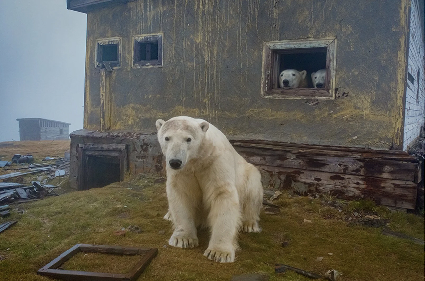
Eventually, the sea ice thickened. It was early fall, the best time of year to travel up there because the ice is at its minimum, and they were not expecting this obstacle.
One day, a storm caught them in the middle of the Chukchi Sea and forced them to take refuge behind a small island named Kolyuchin. Today, Kolyuchin is entirely abandoned, but it was a thriving community when I first visited it 36 years ago as Pravda’s polar reporter.

The story of Kolyuchin Island
Kolyuchin’s name tells its history. Kulusik means a “field of sea ice” in the Chaplino Eskimo dialect, while Kuvluch’in means “round” in Chukchi. Indeed, from above, Kolyuchin looks almost round, and since ice and snow cover it for nine months a year, it is almost always white.
For millennia, Kolyuchin has been a hunting ground both for the Chukchi and the Yupik, who shared the island. Some lived all year round in a small settlement, while others migrated here in the summer to hunt walruses, seals, and polar bears, and to collect berries, mushrooms, and eggs.

Then, in 1934, at the height of Soviet colonization of the Arctic, a polar meteorological station was built on the island. This was not an easy ordeal for those assigned there. Logistics were horrible, and there was no fresh water. By then, the indigenous name of the island had become russified into Kolyuchin, which literally means “a prickly place”.
The indigenous elders who grew up on the island told me another story of Kolyuchin’s name. According to their version, Keglusin means a lonely maritime giant, or rather, a lonely adult walrus who had lost its mother too early, in infancy. It grew up to be mean and aggressive, attacking everyone.
The island was apt for such a legend, because of its humongous walrus aggregations. They gather in the thousands on the rocky beaches.
Kolyuchin abandoned
Time stopped on Kolyuchin in 1992, soon after the collapse of the Soviet Union. Because of lack of funding, the polar station, like many others in the Arctic, shut down. Today, Kolyuchin is wilderness with a few derelict buildings. Occasionally, locals come here by boat or dogsled from nearby Nutepelmen, 14km away, to hunt.

'We noticed a movement in the window'
“There was a lot of wind, rain and fog," said Kokh when we spoke over the phone. "As we were waiting for the weather, we noticed a movement in the window of the abandoned station. This was strange. I grabbed the binoculars, and to my amusement, I saw a polar bear in the house. And then another one, and another. We could not land, so I flew my drone.”

“One never knows what and when nature presents you with. I just know that the best gifts come when we least expect it. One has to be ready.”
And ready he was. As a tech guy, Kokh has played with drones for a long time. None of those on the market were good enough for what he wanted, so he decided to build his own. He used a regular DJI Mavic 2 and modified it with low-noise propellers, which he ordered on AliExpress from China. Kokh knew that the model's original noisy propellers would scare the animals off.
He also developed a special tactic, similar to the one used by indigenous polar bear hunters. He approached them slowly, zigzagging and avoiding a direct advance. This worked well on Kolyuchin: The bears just took the drone for a low-flying gull and went about their business. You can see his successful approach in how relaxed the bears are in the photos.

Important not to disturb the animals
“When my photos went viral, I did not want to say too much about how I made them," says Kokh. "But later, as most people came to believe that I simply walked with the bears, I thought that sent the wrong message. A human should not walk with the bears, for the good of both. So I decided to make it clear how exactly I produced these images.
“Drones are easy to operate, but one has to be extremely cautious not to disturb the animals, and this takes a lot of knowledge of psychology, as well as tech skills.”
Most arctic cruise ships, for example, don't allow its passengers to fly drones, because they can't be relied upon to have Kokh's sensitivity or knowledge to avoid disturbing the animals.
Polar bears have become a symbol of climate change. Photographers often picture them on dwindling pieces of sea ice amid rising temperatures. The images convey a message of grief at the prospect of their disappearance.
Kokh’s photos portray the bears in a happier light. They seem to be thriving in the remnants of human civilization. It may be an illusion, because the bears live among rusted oil drums, debris, and dilapidated huts. But the overall impression gives a message of thriving life, overcoming disintegration, a mood of hope.

Why do the bears go into cabins?
This morning, I called a few biologists who have studied polar bears all their lives. None could explain why polar bears would inhabit a human house.
But Anatoly Kochnev, a polar bear specialist living in Anadyr, Chukotka, who had spent 18 seasons on Kolyuchin, had his own hypothesis.
According to Kochnev, polar bears on Kolyuchin are quite familiar with humans. They have been hunted here for centuries, and even now occasionally local residents shoot an animal or two, although it is against the law. So bears use the polar station as a refuge. Once a boat shows on the horizon, with all its familiar sounds, they retreat into the building.
Shortly before Kokh arrived in the area, a cruise ship did turn up nearby. They drove along the coast in Zodiacs, photographing the shore bears through long lenses.
Kochnev has managed to create Russia's first database logging the conflicts between polar bears and humans. He recalls that in his first five years of work in the Arctic, he saw polar bears only twice. In those days, the bears lived on the sea ice, far from settlements. Today, polar bears are often forced into settlements because the summer sea ice has vanished.

A future truce?
But even their increasing presence near people may be workable. Kochnev points out that polar bears, unlike brown bears, are not territorial. Near Cape Schmidt, there is a Chukchi settlement named Ryrkaypiy. Every fall, dozens of polar bears gather on the beach, just two kilometres away from the village, waiting for new ice to form, as in Churchill, Manitoba.
Over the years, humans and animals have somehow learned to respect each other’s privacy. Maybe there is a way for people and bears elsewhere to become good neighbors in the Arctic.
There is a legend in Greenland, which I first heard 10 years ago in Qaanaaq. This is how it goes. In the old days, polar bears used to be people. After a while, they would go back to their homes, take off their heavy fur coats, sit down around the table, and have some tea. It was a time when humans and animals lived in harmony, and the circle of life was unbroken.
Even though most people have never heard of this legend, the hopeful, unifying message of Dmitry Kokh’s images somehow resonate within us.


Visual artist Galya Morrell has lived and traveled in the Arctic for over 30 years. Under the stage name ColdArtist, Galya explores the limits of the body and the possibilities of the mind, working in a rare genre of visual synthetic performance on the drifting sea ice. Together with Greenlandic polar explorer and actor, Ole Jorgen Hammeken, Galya has founded many cultural initiatives focused on the circumpolar regions.
As satellite tracking has become more common, we've learned more about the impressive long-distance treks of supposedly non-migratory creatures. Two years ago, we reported on an arctic fox that wandered 3,500km from Norway to Canada over the Arctic Ocean ice. Now an arctic hare, normally a stationary creature, has hopped almost 400km in 49 days. It's the longest journey of any hare or rabbit on record.

The individual, known un-anthropomorphically as BBYY because of the color of her ear tags, was collared in the summer of 2019 at Alert, an old Canadian Forces base dating back to the Cold War. It was built to eavesdrop on Soviet communications and is still active.

BBYY was one of 25 hares fitted with a satellite transmitter. She gave birth around Alert, then in mid-September, she began her marathon trek southward over the Hazen Plateau until well past Lake Hazen, the largest High Arctic lake in the world. The Hazen area is one of a handful of polar oases, where summer weather is mild for its latitude and the vegetation is particularly rich.


Other hares took slightly shorter jaunts
Of the 25 hares collared at the same time, 20 of them likewise undertook long fall treks between 113km and 310km. But BBYY covered by far the most ground of all.
Of all the species of hares and rabbits, only the black-tailed jackrabbit is classed as migratory -- and its wanderings take it less than 10km.
Besides their unparalleled restlessness, arctic hares that far north have two other unique habits: Every few years, they form herds, sometimes a few dozen, sometimes in the thousands. An observer flying in a helicopter near Lake Hazen once spotted a snow-covered mountain. Not an unusual sight 1,000km from the North Pole -- but in this case, the snow was moving. Arctic hares in lower parts of the Arctic do not form herds.
They also hop sometimes on their hind legs. Explorers who first saw this did not believe their eyes until they saw just the hind prints in the snow.

After its long journey, BBYY doubled back toward Alert, eventually stopping about 100km away. Then, as the long winter darkness settled in, it died, according to ecologist Dominque Berteaux of the Université du Québec, who led the study.
On January 13, at the coldest time of year, Stefano Gregoretti and Dino Lanzaretti began a 2,000km expedition through Siberia.
The journey is split into two legs. Currently, they are cycling 1,200km, in temperatures as low as -60°C, from Oymyakon to Verkhoyansk. The two villages are the two coldest settlements in the world. Then in summer, they will stand up paddleboard 750km along the Yena River from Verkhoyansk to the Arctic Ocean.
They have named their challenge Siberia 105° to highlight the 105°C temperature range now experienced in Siberia because of climate change. In winter, the temperature in Verkhoyansk can plummet to -67°C, while last summer, it rose to 38°C.

Although that part of Siberia is known for its large temperatures fluctuations because of the continental climate, no one has ever experienced such a drastic and destruction range. Scorching summers have caused wildfires that don't die out, even in winter. The permafrost is thawing, destabilizing the structures built on top of it. It also releases greenhouse gases into the atmosphere.
The Italian duo arrived in Siberia on January 7. Six days later, they began their journey. Pedaling through Oymyakon, they stopped at the marker known as the Pole of Cold. Oymyakon holds the record for the lowest temperature in the northern hemisphere ever recorded: -71°C.

The Keeper of the Cold
At the monument, they met a flamboyant character known as Chryskhan, the Keeper of the Cold.
In 2014, another Western visitor, Felicity Aston, explained the Keeper's significance:
"Striding around the monument was a figure clad in a magnificent floor-length coat of shimmering blue trimmed with white fur and studded with colorful beads that tinkled like broken ice when he moved," she wrote. "Wearing a headdress in the shape of entwined bull horns, he carried a staff decorated with white horsehair. He introduced himself to us as Chyskhan, the Lord Keeper of the Cold.
"In Yakutian mythology, Chyskhan is responsible for distributing winter across the globe. Every autumn, a dozen or so of the 25 official Santa Claus equivalents from various cultures around the world gather in Oymyakon to collect symbols of cold from Chyskhan. They return in spring to hand back the tokens."
Early problems
Unofficial send-off aside, the first few days of the Italians' expedition have not been easy. Problems soon began with the gearbox on Lanzaretti’s bike. They had to take it apart and reassemble it -- no easy matter in those temperatures.
At least, the pair are experienced in the cold. In 2017, Lanzaretti cycled across Siberia in winter. And Gregoretti is an endurance athlete who has covered many kilometres in extreme cold and cycled through the Canadian Arctic.
Hans Henrik was an unusual polar explorer. He went on five dramatic arctic expeditions and saved the lives of many of polar explorers, but he was always homesick.
Henrik was a family guy who loved his kids and wife so much that he refused to go on expeditions without them. So they accompanied him. His youngest son, Charlie Polaris, was born on board Charles Francis Hall's ship, the Polaris, just before it ran aground. The newborn baby then participated in a 2,900km, six-month drift on a disintegrating ice floe.

Geese were the messengers
Two months ago in our present era, in Qeqertarsuaq on Disko Island, we were following a flock of Canada geese for no apparent reason. The geese were not supposed to be here at this time of the year. By mid-September, they should have all been en route to Canada. But this summer was eternal, and here they were, devouring the late blueberries and getting fatter. Instead of flying away, they were leading us somewhere.
They took us to the local cemetery, to some old graves. There were no berries here. They walked across old stones and suddenly took off. Making a circle above our heads, they then vanished, leaving us alone at the old grave.
That was a sign. Geese were the messengers, as they say in Greenland. The geese brought us to Suersaq, a.k.a. Hans Henrik, the great Inuit polar explorer.

Two islands have been named after Hans Henrik, and a stamp in Greenland honors his memory. But his posters do not adorn the walls of aspiring polar explorers, and his Inughuit name, Suersaq, is known only to aficionados.

Some say that Suersaq did not take Arctic expeditions seriously, that he saw the efforts to map the Arctic as a substitution for a big polar bear hunt. Indeed, Suersaq had no ambitions to be “the first” in the race to the North Pole. Like Ootaah and other Inuit explorers, he did not join these extreme expeditions with endurance records in mind. It was life as usual, though his employers called it "an expedition".
But it was his practical skills, endless adaptability, and unbreakable spirit that helped save qualified Europeans and Americans. They came to the Arctic with a mission but instead went into survival mode when Sila, the weather, had a final say.
A life of freedom
Suersaq never thought of himself as a pioneer or a hero. He did not attribute what he did daily to courage or endurance. Instead, he was vulnerable and emotional, he felt threatened among foreigners, but he was who he was.
He deserted the first expedition he took part in because that life got too boring. Instead, he fled with his fellow Inughuit to live an unstructured life. The Inughuit were free, while the expeditioners were not.
During his flight, he hunted polar bears and found a girl, Mequ, the love of his life. That was much more fun than establishing some official and -- from his point of view -- irrelevant record, like reaching the 82nd parallel by dogsled. Besides, he knew that his Inughuit buddies had trod this ground previously on many hunts and none of them saw it as a special accomplishment.

First Inuit man to write a book of exploration
Yet Suersaq was an educated man. He wrote a book about his arctic adventures, the first Inuk to have done so. Originally composed in 1877, it has often been reprinted. Memoirs of Hans Hendrik, The Arctic Traveler gives details of the Kane, Hayes, Hall, and Nares expeditions, as well as an account of August Sonntag's death. Suersaq wrote it in Kalaalissut, the Greenland language, and Hinrich Rink, the colonial director for Greenland, translated it into Danish and English and published it.
Born in the southern settlement of Fiskenæsset (today Qeqetarsuatsiaat), some 100km south of Godthåb (today Nuuk), as Hans Hendrik, Suersaq was raised in the Moravian faith and attended a Moravian school, where he learned to write and read.
His first expedition
At age 18, Suersaq was already an excellent subsistence hunter and great kayaker. Not surprisingly, the American explorer Elisha Kent Kane recruited him. Kane was commander of the Second Grinnell Expedition, bound for the island’s northern end to search for John Franklin's lost expedition.
Examining the fate of past American misadventures in Northwest Greenland, Kane knew that the only way to survive in these latitudes was to live Inuit-style. He was looking for someone who could be a perfect Inuit: a dogsled driver, a kayaker, a hunter, and an interpreter.

Kane says of Suersaq: "I obtained an Eskimo hunter at Fiskernaes, one Hans Christian (known elsewhere as Hans Hendrik), a boy of eighteen, an expert with the kayak and javelin. After Hans had given me a touch of his quality by spearing a bird on the wing, I engaged him."
Suersaq accepted the offer since he had to help his elderly parents.
After a rapid start, the expedition got stuck near Cape Alexander, in the Thule District, for two long winters. It was in the winter of 1854 when Suersaq became famous and a much-desired guide among American explorers. When four men disappeared on the ice, he found their sled track and brought a rescue party to the frozen men. When expedition members started to starve and developed scurvy, he was able to get food. Once again, he had saved the party.
Free spirit
Suersaq was skillful but he was a free spirit. The expedition routine was too boring for him. He was also frightened by the white men, whom he thought were going to harm him. Something might have been lost in translation, but this is how he felt according to his book. So when he met the local Inughuit of far northern Greenland (a different culture than the more southerly one he came from), he fell in love with their lifestyle. They were truly independent. The Americans were not. So he left with the Inughuit.
It was a brave move. At that time, the West Greenlanders saw these northern denizens as dangerous outcasts. There were superstitions, but Suersaq managed to overcome them. Yet as a devoted Christian, he worried for the Inughuits' souls.
A time of gifts
Suersaq received two very important gifts during his escapade. First was the beautiful Mequ, who became his wife and had four children with him. The second was his name, Suersaq. According to Nuka Muller, one of the most prominent Eskimologists of our time, Suersaq is an Inughuit name that means “the saved" or "the healed one”. It was bestowed only by Inughuit angaqqoks (shamans), which for us means this: Hans Henrik had to work hard to deserve it.
Despite his desertion, Kane so highly valued Suersaq that he named an island north of Etah after him.
When a member of Kane’s expedition, Isaac Israel Hayes, started a new expedition toward the North Pole in 1860, he invited Suersaq to join him. Suersaq agreed under one condition: He would not leave without his wife and son. This was not an easy decision for Hayes, but he agreed to let them join the expedition.
Suersaq provided food and shelter for Hayes and his men, while Mequ fished, cooked, sewed, and kept the seal-oil lamp burning. She turned out to be a valuable addition to the expedition too, and the couple’s fame increased.
Hayes' expedition failed to reach the North Pole. It also lost a man, the second in the command, a German astronomer August Sonntag. Sonntag fell through the ice during a sledge journey with Hans. Though Suersaq saved Sonntag from the freezing water, almost dying himself, he could not save his life. Sonntag died during the night from hypothermia. Suersaq was on the verge of death too, but he managed to reach the Etah Inughuit and find refuge.

The arrival of the Polaris
After the departure of Hayes, Suersaq spent 10 years in Upernavik working for the Royal Greenland Trade Company. Then one day, another ship with a mission to discover the North Pole arrived. This time it was Charlie Francis Hall, the leader of USS Polaris, who asked Suersaq to join his expedition. Suersaq had the same answer as before: He would not travel without Mequ and the kids. This time, there were three of them. Hall accepted.
The Polaris managed to go further than any ship before her, but then, in the northern part of Nares Strait, Hall suddenly fell ill. He died in Thank God Harbor two weeks later, apparently from poisoning. Shortly before his death, Hall named another island after Suersaq. This time it was Turtupaluk, which means a “kidney” because it looks like a kidney, a rocky island in Nares Strait. Hall named it Hans Island.
A barren, steep-sided, one-kilometre-wide bit of land, Hans Island has become modestly famous in recent years, because both Canada and Denmark claim ownership of it.

Six months on an ice floe
After losing their leader, the Polaris eventually turned south. One night in October, she became trapped in the ice in Smith Sound. Fearful that the pack ice would crush her, the crew prepared to abandon ship. Fourteen people stayed on the Polaris, but 19 off-loaded supplies and found refuge on an ice floe. Thus started a six-month drift, one of the most dramatic survival stories in the history of arctic exploration.
Suersaq, Mequ, their children, and two other Inuit from Canada, Ipirvik and Taquilittuq, also with a baby, took care of the American, German, Danish, and Swedish explorers. They built three igloos, and Hans was able to hunt seals. The Inuit families cooked on the seal-oil lamp, to save fuel. The Europeans did not like the smell and used one of their two remaining boats as fuel instead. The clash of cultures was obvious.
When the dogs got into the storage and ate much of the provisions, the Europeans shot five dogs on the spot. They looked on in disgust when the Inuit made a feast from the killed dogs, not wanting to waste the meat. Little did they know that in about two months they would be happy with the dog meat. By then, the crew would have to live off boiled dried seal skins, which were almost impossible to chew. If they were lucky, they'd get some seal entrails and frozen blubber.
In March, after reaching Nares Strait, the ice floe started to disintegrate. Suersaq was helping people to switch between the boat, which was too small to hold everyone (remember, the second boat was burnt), and the small ice floes. He did this 24/7 until the last day of April when the castaways spotted a ship.
They fired guns, jumped, and shouted. But it was all in vain, they were too far away to be noticed. Suersaq jumped into his skin kayak and rushed to the sealing ship. Once again, he was a savior.
Thirty years of adventure
Two years passed and another expedition, this time the British Arctic Expedition led by commander George Nares, recruited Suersaq. Again, Suersaq agreed.
This time, he left his family behind. It was a mistake. He felt lonely, missed his family, did not trust foreigners, and was soon thinking of escape. He was relieved when he finally returned home.
In 1883, 30 years after he joined his first arctic Expedition, a Swedish expedition to Cape York recruited Suersaq for one last season. He joined only for the summer. He knew that his time in the adventure world was over.
Suersaq died in 1889 at the age of 57 and was buried in the cemetery above Qeqertarsuaq.

Gone but not forgotten
We found some of his old photos and the first edition of his book in the Museum of Qeqertarsuaq, but we made our best discovery in the community house. We gathered there for an evening concert. The leader of the Inuit theatre troupe from Nuuk was our friend, a young talented actor and designer born in Qeqertarsuaq. His name is Hans Henrik Suersaq Poulsen. He is Suersaq’s direct descendant.
Suersaq Junior performed a play about his great-grandfather. This is what he says: “We have heard so much of the qallunaat (white) explorers like Knud Rasmussen and Robert Peary, and so little about the Greenlanders who ensured that these expeditions were a success. We wanted to tell their part of the story. And naturally, Suersaq was to be a part of the show because he was the first Greenlander to be a part of a big expedition.”
While Suersaq Sr. explored the High Arctic, Suersaq Jr. explored a place between tradition and modernity.
The lesson of Suersaq
In recent months, my partner Ole Jorgen Hammeken and I were asked to teach young Inuit children some survival skills. We gave practical classes to children in Qeqeratarsuaq and Ilulissat. We decided to base our classes on Suersaq’s drift.
At first, we started our drift on one oversized sheet. At the start, it could fit a tent and 20 people. As the game progressed, we folded the sheet, making it smaller and smaller. Finally, it was able to fit only four people. The greatest surprise was that the children found ways to continue the drift, very similar to Suersaq’s methods.

Those born in the Arctic are prepared for abrupt change. It is your everyday life, life as usual. It is really easy to brainstorm with the Inuit children who literally live on the ice. And now, their real-world knowledge is backed up with academic knowledge. These children, many of whom are young dogsledders, young scientists, and artists as well, will lead the world in future arctic exploration.
During a 30-day canoe expedition in Canada's central Labrador last summer, a predatory black bear almost ambushed two canoeists.
Covered in bug jackets against the tundra's clouds of mosquitoes, they were returning to pick up their canoe for the second part of their portage toward the Kogaluk River, one of the peninsula's challenging whitewater streams. They were laughing and joking around and filming themselves. One of them heard the charging bear at the last second and wheeled around, shouting. The two of them yelled and waved and managed to keep the bear at bay. It was very reluctant to leave. The incident happens shortly after 1:48 on the video below.
They had proper deterrents with them, a shotgun and some bear spray. But as they admitted in the written intro to the YouTube clip, they made the mistake of leaving their firearm at the endpoint of their first carry. And the bear spray was back in the canoe. They had nothing with them at the time of the attack.

I've traveled Labrador a lot and am familiar with the area where they were. Labrador's black bears are large and sometimes aggressive, and I've had to scare a few away. But my closest calls have been further north, with polar bears. I too carry a shotgun, bear spray in summer only (it doesn't work well at 40 below), and aerial flares to fire in front of an approaching bear.

Flares have been my most effective deterrent but they would have caused problems here. The white-hot burning magnesium would have set that willow underbrush on fire. It could quickly have burned out of control. You can only use flares in a true arctic environment, where there are no brushy plants, or in winter with polar bears (when other species are hibernating).
It is very easy to let your guard down as they did. They'd been out for at least a couple of weeks. Nothing bad had happened. Likely, they hadn't even seen traces of a bear. It is easy to become complacent after many uneventful days.
They appear out of nowhere
Yet it is astonishing how quickly a large animal like a bear can appear out of nowhere in that open environment, with its seemingly endless visibility.

I've had two incidents where polar bears caught me off guard at close quarters. Once, I'd just set up my tent on the sea ice off Ellesmere Island. I went about 15m away from the tent, where the shotgun was, to pick up a heavy chunk of tidal ice to help weigh down the tent.
Suddenly, a polar bear appeared about 10m away from behind some pressed-up ice. We stared at each other for a few moments. The gun felt miles away. Then the bear made a decision to exit the encounter in a dignified way. It began sniffing the ice, like someone whistling past a graveyard, and wandered off. As casually as I could, I went back to the tent to retrieve the shotgun. But the bear had made its decision, and it was soon out of sight.
On another occasion, I was pulling my sled over the sea ice, also off Ellesmere. I was a few hundred metres ahead of my partner and had to go to the bathroom. Because he was following my trail, I unclipped from the sled and moved about 15m to one side, so he would not have to see a turd when he passed by.
My bibs were around my ankles and I was squatting down when a polar bear appeared just a few metres away. Where on earth had it come from? The bear was as surprised as I was but it wasn't in a predatory mood. It wandered off, while -- my ass still hanging out -- I waddled back to the sled, where the shotgun sat, in case it changed its mind.
That would have been a very embarrassing demise.
All unharmed
It's hard to know what I could have done differently in these cases. I do carry protection when I go off some ways for toilet duties around camp, but this was just a short few metres away. Yet in both these cases, I was as naked and unequipped as these guys in Labrador.
The two canoeists seemed to handle the situation well. They shouted, raised their arms above their heads, faced the bear. They looked for rocks or logs to throw, but couldn't find any right away. Meanwhile, the bear seemed to be just waiting them out, looking for an opportunity to score some food somehow.
It's likely that on subsequent portages, they kept their shotgun, bear spray, or both with them at all times. In the end, any encounter that leaves both people and bears unharmed is a success.

Scientists have discovered a newly established colony of 75 gentoo penguin chicks on little Andersson Island in Antarctica. It is the first documented gentoo migration to the archipelago, an unusually southern location for the breed.
Gentoo penguins are inclined to relatively temperate, ice-free zones. Until recently, conditions within Andersson Island's latitudinal band were too icy for gentoo chicks. Similar migratory trends observed with other species suggest that the birds are responding to fast-rising global temperatures.

Antarctica and climate change
The Antarctic Peninsula is one of Earth's most rapidly warming regions. Temps there have risen 3° C on average since the early 1970s. What may seem like a minor increase has already proven catastrophic for the area's fauna and flora.
Elimination of livable terrain through industrial fishing, glacial calving, and rising sea levels, as well as the sweating-out of sensitive species, has resulted in monumental habitat losses and food chain disruptions. A recent expedition to Elephant Island found that chinstrap penguin colonies had collapsed by as much as 77% in 50 years.
Gentoo penguins as climate sentinels
Though research on Andersson Island's fledgling penguin colony has just begun, experts say the reason for the bird's uncharacteristic migration is apparent. The gentoo penguin was expelled from a region they've inhabited for millennia by a very sharp and fast uptick in atmospheric heat. The same warming effect also morphed an intractable polar region into a relatively hospitable landing for the flightless birds — at least for now.

The discovery has spurred renewed calls from the scientific community to establish a network for marine protected areas in Antarctica to help safeguard the region in the face of a rapidly changing climate.
"Penguins are a sentinel species and a great indicator of the health of the Antarctic ecosystem," stated the expedition's lead ecologist, Dr. Heather Lynch. "As expected, we're finding gentoo penguins nearly everywhere we look –- more evidence that climate change is drastically changing the mix of species here on the Antarctic Peninsula."
Kuwaiti mountaineer Yousef Al-Refai has become just the 24th person to climb each continent's tallest volcano. Although the Volcanic Seven Summits do not enjoy the same notoriety as the Seven Summits, ascending to their seven calderas is an even rarer achievement.
Early reports suggested that the Kuwaiti was the youngest person to complete the circuit. However, reader James Stone, who maintains a list of all successful volcanic seven summiters, pointed out to ExplorersWeb that one of the very first summiters, Crina Popescu of Romania, was just 16 when she completed the list in 2011. Al-Refai is 24.
Al-Refai's multicontinental project ended on December 22, 2021, atop Mount Sidley (4,285m), a dormant volcano in Antarctica's Marie Byrd Land. It took the team seven hours to push from their camp at 3,000m to the crest of the caldera.
In a report to the Kuwait News Agency, Al-Refai stated that climbing Sidley was relatively easy and non-technical, "but the extreme cold is the factor of difficulty. We had to carry our luggage in the backpack, weighing 15kg, while the other part was in the sled, which weighed 25kg."
The sun may still have been out at the time of his team's ascent, but the temperature stood at -35˚C.

Yousef Al-Refai's volcanic journey
The Volcanic Seven Summits is a relatively young circuit, first accomplished by Italian Mario Trimeri and Romanian Crina Popescu in 2011.
Al-Refai began his own Volcanic Seven journey a few years after Timeri and Popescu's completion of it, and nearly six years to the day before his final ascent in Antarctica. He logged each of the Volcanic Seven Summits in the following order:
- Mount Kilimanjaro, Tanzania - December 30, 2015
- Mount Elbrus, Russia - July 18, 2017
- Mount Giluwe, Papua New Guinea - July 21, 2018
- Pico de Orizaba, Mexico - January 6, 2019
- Mount Damavand, Iran - August 11, 2019
- Ojos del Salado, Argentina/Chile - January 15, 2020
- Mount Sidley, Marie Byrd Land - December 22, 2021
Since Al-Refai's summit, two more have joined the still-rare list of those who have completed the circuit. Below, James Stone's complete list of summiters:

Our final Antarctic update of the season covers Masatatsu Abe’s aborted expedition and Erik Bertrand’s solo ski expedition from Berkner Island to the South Pole.
Masatatsu Abe
After a couple of days stuck in his tent, the weather improved enough for Abe to reach a safe pick-up point. ALE has transported him to camp and his support team report that he is in “good physical and mental health.”
In the end, Abe moved too slowly to make the Pole. Soft snow and poor visibility hampered him and he eventually stopped in the Transantarctic Mountains.
Abe will now fly back to Japan via Chile.
Erik Bertrand
An expedition that flew under our radar this year, Erik Bertrand set off solo from Berkner Island on November 17. On January 15, he completed his 60-day journey to the South Pole.
Bertrand reported soft snow and warm temperatures on Berkner but made good progress until around 86° south. Here, he ran into some poor weather, with frequent whiteouts and snowfall. The slower pace, combined with rations that may have been a little, uh, light, meant that Bertrand had a nervy final run to the Pole. He finished with no food to spare and has lost a whopping 28kg!

If you live near London, England and love stories from the Golden Age of Antarctic Exploration, now is your chance to pick up an entire library about that era.
As part of an estate sale, a seller on eBay has put up a relative's entire collection of 154 books about Antarctic exploration. Some are contemporary, such as Sara Wheeler's Cherry: A Life of Apsley Cherry-Garrard. Others are classic first editions, such as Scott's Last Expedition, Volumes 1 and 2 from 1913.
The mix includes everything from ex-library books in poor repair to a copy of South with Scott, signed by Edgar Evans before his demise with Scott on the return trek from the South Pole.
The seller insists on pickup only, so if you can't make it to North London to pick up the six fruit crates of books yourself, you're out of luck.
The bidding ends on January 27.
Believe it or not, Svalbard, Norway has famously reliable internet — and has since 2003. The remote arctic archipelago sits almost 2,000km away from the mainland, at about 80˚N, but its nearly 3,000 residents have surfed the web for years, thanks to a network of fiber-optic cables that cover the distance underwater.
But sometime prior to the wee hours on January 7, something — or someone — cut one of the links. Now, Svalbard authorities undertake what could be a drawn-out investigation to find out what or who did it. According to Norway’s intelligence agency, blame could land on Russia.
Svalbard's world-class internet takes a hit
Initially, multiple interest groups worked to establish the Svalbard Undersea Cable System to help the island's satellite-receiving stations relay information to the mainland.
As soon as the switch flipped on, Svalbard’s population benefited distinctly. The island was among the world’s first to get a 4G network, and it’s been on 5G since 2019.
The connection runs through twin fiber-optic cables on the floor of the Norwegian Sea. The redundancy adds capacity, but also security. If one line goes down, the other simply continues to transmit.
Space Norway, the Norwegian Space Agency’s operational arm, now owns the system. At 4:10 am on January 7, it discovered a disconnection in one of the cables. It then traced the location to a precipice where the seafloor drops off dramatically from 300m to 2,700m.
Analyzing the situation, the organization decided to scale back non-essential activity until it could orchestrate a repair. Service remains online, but the limited capacity could last a while — Space Norway expects to begin repair work in February.
Possible causes: European authorities wary of Russia
Underwater fiber-optic cables commonly break, often by accident. Fishing gear or boat anchors are typical culprits, and their owners sometimes get held accountable in such cases.
However, the Norwegian Intelligence Service (NIS) reportedly stated in its annual threat assessment that Russia is developing the capacity to damage underwater pipelines and cables. Published in October, the document preceded comments by NIS Chief Nile Andreas Stensones in which he said Russia poses the "greatest threat" to the country in terms of cyberattacks.
British Defense Chief Sir Tony Radakin also recently alleged that Russian submarines pose an increasing threat to undersea communication cables.
It is, and likely will be, impossible to prove for quite some time whether Russia or Russian assets caused the damage. In the meantime, a host of other accidental causes threaten underwater pipelines and cables throughout the Arctic. In addition to fishing, icebergs and trawling can also damage cables.
Accidental incidents occur notably often. In one several-month period between 2018 and 2019, a fiber-optic cable between the Canadian mainland and Greenland broke three times. Two of the breakages were accidental, while the third remains unidentified.
For now, Svalbard locals can do their own research — albeit more slowly than they’re used to.
On the sea floor of Antarctica's Weddell Sea, researchers have discovered the world’s largest fish breeding ground. More than 240km wide, the area hosts 60 million nests of the elusive icefish.

Biologist Ditlef Rustad first discovered the icefish in 1927 in the Southern Ocean off Bouvet Island, the world’s most isolated island. So far, there are 33 known species of icefish. Sometimes known as the crocodile fish because of its unusually long snout and gray-brown color, it is 25-50cm long and its translucent skin lacks scales. It feeds on krill and other small creatures.
The white-blooded fish
Most importantly, it is also referred to as the “white-blooded fish” because it is the only vertebrate that lacks hemoglobin and red blood cells. Instead, its cardiovascular system consists of a larger heart and larger blood vessels, thereby pumping higher volumes of blood to compensate. Their lack of scales also may allow them to absorb more oxygen from the surrounding waters. The Antarctic Ocean is already very rich in oxygen. The fish has evolved to manage this harsh environment.

Other than this, we don't know much else about them…until now. Scientists from the Alfred Wegener Institute for Polar and Marine Research unexpectedly came across the giant colony of these fish while researching something else in the Southern Ocean. A special bathymetric camera documented perfectly spaced-out nests, which are little mounds of mud and small stones. Each nest contains up to 2,000 eggs. An adult icefish floats just above each nest, on constant guard.
Underwater cameras will continue to monitor the site until scientists return this April to continue their studies of this rare fish and its mating habits. The video below shows a tiny section of this almost endless hatchery.
A passion for the natural world drives many of our adventures. And when we’re not actually outside, we love delving into the discoveries about the places where we live and travel. Here are some of the best natural history links we’ve found this week.
Ocean secrets
Sea dragon skeleton found in the UK: Conservationists have found the fossilized remains of an ichthyosaur at the bottom of a reservoir in England. The “sea dragon” is one of the largest and most complete skeletons of the species found to date.
The conservationists were draining Rutland Water Nature Reserve as part of a landscaping project when they stumbled across the remains in 2021. “We sort of looked at it and scratched our heads…we could see these ridges and bumps. That’s when alarm bells started to ring,” said Mr. Davis. He took photos and sent them over to the geology department at the University of Leicester. “I immediately recognized them as ichthyosaur vertebrae,” said Dr. Lomax, who went on to lead the excavation.
Ichthyosaurs were marine reptiles that first appeared 250 million years ago. This skeleton dates back 180 million years, to the early Jurassic period. The intact skeleton amazed Paleontologists, they had expected to only find fragments. Icy conditions meant they were unable to extract the skeleton, so they covered it with plastic sheets and mud and then returned in August. Researchers are now preserving the skeleton and removing rocks from the bones.
World’s largest fish breeding ground discovered: Scientists have discovered the world’s largest fish breeding ground in Antarctica. Marine biologists discovered approximately 60 million icefish nests on the floor of the Weddell Sea. Each nest contains up to 2,500 eggs.
Scientists started exploring the Weddell Sea in the 1980s but found only small clusters of nests previously. A German research vessel found the huge expanse of nests whilst conducting routine observations. “The idea that such a huge breeding area of icefish in the Weddell Sea was previously undiscovered is totally fascinating,” says Dr. Autun Purser. Scientists are calling for governments to create a Marine Protected Area to safeguard the breeding grounds.

Warrior women
Remains of 3,000-year-old warrior women found in Armenia: Three millennia ago, many civilizations across the Mediterranean collapsed. Archeologists have now discovered the remains of two female warriors in the Jrapi cemetery, Armenia. Initially, they assumed the skeletons were male as they were buried like honored warriors. Testing has proved they were women.
Both women would have been horse-riding warriors who fought for their communities. Their remains show that both women experienced significant trauma before they died. The first skeleton is of a 45 to 50-year-old woman; she had a dent in the back of her skull. The arrow that killed her was still lodged in her ribcage. The second woman was much younger. She had been shot in the ankle, stabbed in the jaw, and had blunt force dents in the back of her head.
A new frog and ageless ants
New Rainfrog species discovered in Panama: You can find Rainfrogs across South America, with a few species present in Central America. There are 574 known species of these often-colorful frogs, but they are relatively understudied. Their variation in color and morphology can make it difficult for biologists to decipher between species by sight alone.
Scientists have found a previously unknown species of rainfrog in Panama. They have named it Pristimantis Gretathunbergae after climate activist Greta Thunberg.

The never-aging ants with a terrible secret: In the forests of Germany a group of ants has done the seemingly impossible, they have stopped the aging process. While some temnothorax ants in the colony age as normal and die after a few months, some live for years. These ants maintain the soft outer shells and tawny shading signifying a juvenile. All these ageless ants have one thing in common, their bellies are teeming with tapeworms.
The parasites prolong the lifespan of their host dramatically. Researchers think the affected ants can live for over a decade. The temnothorax ants become host to the parasites when they ingest bird feces containing tapeworm eggs as larvae. Researchers found that the tapeworm-infected ants also did less work than other ants in the colony. The normal ants treated them as juveniles and groomed, fed, and carried them around due to their youthful appearance.
Climate change is destabilizing the Arctic
Climate change destroying homes across the Arctic: The Arctic is warming two to four times faster than the rest of the planet. The rising temperature is causing permafrost to thaw across Russia, North America, and Scandinavia. This poses a huge problem for the five million people who live on the Arctic permafrost.
The usually frozen ground is forming sinkholes. Landslides and flooding are becoming more common. Studies suggest that 70% of existing infrastructure is at high risk of damage by 2050. Across communities on the permafrost, water mains are rupturing, houses are becoming unstable, and ponds are forming due to all the meltwater. "If you think about the Arctic, landscape stability is dependent on the threshold of zero degrees Celsius. And as the ground temperature approaches zero, we are seeing huge waves of problems," said Arctic geologist Louise Farquharson.

Could a clone bring this ferret species back from the brink?
Cloned ferret celebrates first birthday: Elizabeth-Ann, the world’s first cloned black-footed ferret, has celebrated her first birthday. This is a major milestone for conservationists; the little ferret is one of the first clones to reach sexual maturity.
Black-footed ferrets are one of the most endangered species in North America. Conservationists plan to mate Elizabeth-Ann in spring. If she gives birth to healthy kits it will be the first time cloning has been successfully used to try and save a species from extinction. If successful it opens the door to use the technique on other endangered species, but if it fails the team worries it will boost skepticism about the value of cloning. “Everything about Elizabeth Ann is much bigger than the science behind it, and it’s much bigger than helping the ferrets,” says Ben Novak.
Scientists cloned Elizabeth-Ann using cells of a female ferret that died over three decades ago. Scientists classed the species as endangered in 1973. Their numbers fell dramatically in the 1970s after prairie dog colonies and their burrows were almost wiped out by farmers and ranchers. Prairie dogs are a crucial prey species for the ferrets.
Last week, Preet Chandi finished her Hercules Inlet to South Pole route. This week, Justin Packshaw and Jamie Facer-Childs have made it too.
Most of this year's few Antarctic expeditions have now finished, but Masatatsu Abe is still out on the ice.
Packshaw and Facer-Childs
Justin Packshaw and Jamie Facer-Childs have endured a torrid time in Antarctica. Their original plan was to kite-ski from the Russian Novolazarevskaya station to the Pole of Inaccessibility. From there, they'd have headed to the South Pole before skiing on to Hercules Inlet. Their plan didn't last long, as the wind refused to cooperate.

With food running out, they abandoned the Pole of Inaccessibility and have now elected to stop at the South Pole rather than continue on to Hercules Inlet. It took the pair 57 days to make the Pole, fighting the wind that they hoped would aid them.
"It has been hard graft and grit has been our constant companion," Packshaw wrote in their latest update. The two men are now enjoying the comforts of the South Pole camp.
Masatatsu Abe
Meanwhile, Abe is still fighting the elements.
His expedition from the Messner Start to the South Pole two years ago was far from smooth. He fought through soft snow but managed to grind out the kilometres and make his goal very late in the season. This year, he won't be able to repeat the feat.

From his starting point on the Ross Ice Shelf, Abe has inched along. Now, at the foot of the Transantarctic Mountains, he has run out of time.
"Unlike before, it is too dangerous here to act in this weather. After consulting with the Base Camp, both sides decided that the Transantarctic Mountains are extremely difficult at present. There is also a pickup time limit, but the weather will be rough and I will be forced to stagnate for several days. As soon as the weather recovers, I will descend about 50km to a flat snowfield where the propeller plane can reach," he wrote on January 11.
Because of poor visibility, Abe might not reach the pickup point for another couple of days.
If the tongue of the Thwaites Glacier collapses, we're in trouble. A massive portion of the 400km-wide glacier in west Antarctica floats on the Amundsen Sea. Consensus holds that if it calves off, sea levels could rise by over 65cm in a matter of just a couple hundred years.
That's why 32 scientists embarked for the so-called "doomsday glacier" from Chile on Thursday. The team, led by Anna Wahlen of Sweden's University of Gothenburg, will explore the sea under the Thwaites with two robot ships during a two-month expedition. By examining the glacier's grounding line (where it meets the Antarctic landmass), it aims to gather information about just how fast it's melting.
'Doomsday glacier' concerns and melt rate
The Thwaites Glacier dumps about 50 billion tons of ice into the sea each year. The British Antarctic Survey estimates that it's responsible for about 4% of the global sea-level rise. The stats don't point to "doomsday" all by themselves, but Thwaites' deteriorating structure has alarmed scientists.
Oregon State University ice scientist Erin Pettit said that the glacier is losing contact with Antarctica at the grounding line. Because of that, a more significant piece than usual could flake off into the ocean, where it would melt more quickly. The floating ice shelf is also fracturing rapidly — 10km-long cracks have recently formed in just a year.

"You have to have both a hold on the rock, and you have to have structural integrity from there up into the glacier," Pettit explained. "What we're looking at is both of those pieces."
Expedition details; Boaty McBoatface stands by
The visiting scientists will study the Thwaites Glacier aboard Wahlen's ship, called Ran, and the agile crowdsource-named drone Boaty McBoatface. Aboard the vessels, they'll record water temperature, monitor the seafloor, and measure ice thickness. They'll study the ice's structure, pay special attention to cracks and tag seals, and help the team gather information on nearby islands.
Thwaites' remote location spurred the expedition. It's proven difficult to study, hundreds of miles from the closest research station.

Wahlen's team hopes to clarify uncertainty over how fast or when a collapse might happen and quantify how much sea levels will rise as a result.
"It's not if sea level is going to go up, it's when and how much,'" Petit said. "The Thwaites project is focused specifically on the sea level rise question and trying to narrow down that."
After COVID waylaid the expedition by a year, it's now underway. The team will arrive at the glacier aboard the research vessel Nathan B. Palmer, which has made the trip before. From there, they'll start their "doomsday" projections.
In this week's update, Preet Chandi arrives at the Pole, Justin Packshaw and Jamie Facer-Childs inch closer, and Masatatsu Abe's expedition balances on a knife's edge.
Packshaw and Facer-Childs
Packshaw and Facer-Childs have made a bit more progress since our last update, edging their way to the Pole, as the map below indicates.

They have covered 1,958km, but the wind let them down once again yesterday. “Not a breath of wind when we stirred this morning, which was pretty much what forecasts had predicted. We decided that we would manhaul to keep some miles coming in and because we need them due to the lean state of our food supplies.”
The pair have struggled to stay on course, fighting with too much wind, too little wind, and wind from the wrong direction.
Martin Hewitt and Lou Rudd
Hewitt’s Achilles held up enough to complete a last-degree ski to the Pole. Rudd and Hewitt arrived at the Pole on the centenary of the death of Sir Ernest Shackleton. They will rest for a few days and then head to Mount Vinson.

Solo Expeditions
Preet Chandi has finished her solo expedition from Hercules Inlet to the South Pole. Chandi completed the 1,126km in only 40 days. “Feeling so many emotions right now. I knew nothing about the polar world three years ago and it feels so surreal to finally be here,” she wrote.
Masatatsu Abe is still slogging his way to the Pole from a unique starting point on the Ross Ice Shelf. He has not been able to match Chandi’s pace. Abe has covered 743km and is on day 48 of his expedition.
He may be running out of time. Abe still needs to cross the Transantarctic Mountains and reach a pickup point before ALE dismantles their camps.
“I've come as far as I can, but it's extremely difficult to reach the South Pole,” Abe wrote in a recent post. "Bad conditions overlapped too much. I'm already full of wounds, but I'll move forward, even one step. to the time limit."
We’ll see how much further he can go before logistical difficulties stop him.
In a recent story, one of our writers wondered whether a dilapidated outhouse on Russia's Wrangel Island was the northernmost outhouse in the world. It isn't. Not even close.
The world's northernmost outhouse sits on Ward Hunt Island, a small satellite off northern Ellesmere Island. Ward Hunt Island has often served as a starting point for full-length North Pole expeditions. It overlooks the Arctic Ocean, at 83˚06', just one nautical mile shy of the northern tip of Canada, at Cape Aldrich. From the outhouse, the North Pole is just 767km away.
Parks Canada wardens from nearby Quttinirpaaq National Park tend the few old military quonsets on the little island. (I've had a duffel of food and fuel stored in one of them for years, just in case I ever need a resupply on my High Arctic travels.) In the 1990s, a warden with a sense of humor decided to paint the little outhouse fluorescent orange, so that "skiers coming back from the North Pole would have something to look forward to."
By contrast, the outhouse at Wrangel Island is at about 71˚N, roughly 1,300km further south.
Arctic graffiti
Another High Arctic outhouse lies at 75˚40'N, at Truelove Inlet on the north side of Devon Island. The outhouse belongs to an abandoned botanists' station from the 1960s. On the inside door of the outhouse, 60-year-old graffiti reminds scientists always to keep their wits about them in polar bear country: "Though you may be enthralled by a passion for flora/Do not ever forget the Order Carnivora."

Still further north, at 80˚N at Expedition Fiord on uninhabited Axel Heiberg Island, scientists have also come every spring since the 1960s to study two glaciers. The hardy glaciologists never bothered with an outhouse. They just use an empty 44-gallon fuel drum with a toilet seat on top, partly buried in the snow. I don't have a photo of the drum itself, but the view from beside it, below, has to be one of the most inspiring outhouse views in the world.

Historic outhouse
Even further north, at 81˚76'N at Fort Conger on Ellesmere Island, is the remains of an outhouse from the Greely expedition of 1881-1884. The outhouse has crumbled, but the door, lying on the ground, is largely intact. More graffiti, still legible after 140 years, decorates the inside of the door. It pokes fun at one of their men, Nicholas Salor, originally from France. It calls him, rather obscurely, "Prof[essor] of Anatomy", clearly an inside joke. An addition at the top of the door further labels him "Frog Eater". Salor later became one of 19 men who died of starvation on that tragic expedition.

Finally, the Norwegian archipelago of Svalbard spans the 80˚N latitude line and has its share of outhouses -- and visitors. All well north of Wrangel Island, which is respectably wild, beautifully arctic, but hardly home to record-setting outhouses.

Once upon an earlier time, I joined a group of Russian scientists on an expedition to Siberia’s Wrangel Island. The purpose of our trip was to document the flora, fauna, and fungi on this remote island in the Chukchi Sea.
Since Wrangel has the largest density of denning polar bears of anywhere in the world, we were obliged to carry a firearm or a can of Mace with us at all times. Being a lousy shot, I chose the latter.
“You need vodka, too,” a Russian botanist informed me, energetically puffing on a Troika cigarette. “Otherwise, you won’t be able to identify unusual species.” He handed me a 1.75-litre bottle of Hammer & Sickle Vodka.
Here I should mention that Wrangel’s landscape remained unscathed by Ice Age glaciers, with the result that it’s more or less been unchanged in the last million years. Endemic species abound. The island boasts 23 plant species found nowhere else in the world, and perhaps half as many endemic butterfly species. Small wonder that it’s become a UNESCO World Heritage Site.

So there I was, wandering the sedge tundra on the eastern side of the island. In a rocky outcrop, I saw a Muir’s fleabane (Erigone muirii), a flowering plant in the aster family first documented by the American naturalist John Muir on an 1881 visit to the island. A short while later, I saw a small, brownish mushroom that turned out to be a previously undescribed Inocybe species.
Then I saw a heap of polar bear shit (poop is an inappropriate word) festooned with seal whiskers, berry pits, a delicate maze of birds bones, and what looked like some kelp. What a splendid work of art! I said to myself.

In a short while, a powerful wind called a yuzhak began blowing, snarling, and whistling across the tundra. Plants such as cotton grass, bladder campion, and alpine arnica as well as Muir’s fleabane sashayed back and forth, repeatedly back and forth, as if they were performing some sort of exotic dance. None of them seemed in danger of being blown down, while I felt like I was constantly at risk of being swept into the Chukchi Sea.
Suddenly I saw an ATV coming in my direction. An ATV seemingly running on its own, without any driver. Would Wrangel Island’s wonders never cease? Then I saw the botanist who’d given me the vodka hunched low against the vehicle’s wheel to escape the blasts of the wind. He saw me and immediately stopped.
“Want to see the northernmost outhouse in the world yet?” he shouted, then gestured for me to hop into his ATV.
Fifteen minutes later, we reached what turned out to be a lavatorial relic from Soviet times. Its wooden walls had mostly collapsed, its floor was a mass of moss, and its lichen-covered seat was not even a semi-circle. What remained was tilted precariously to the starboard. Northernmost outhouse or not, it didn’t seem to care about being listed in the Guinness Book of Records. To hell with celebrity! its ruins seemed to proclaim. All I want is to become part of the remote bounteous earth.
“I don’t want petty self-expression...I want the rhythm of eternity,” Rockwell Kent once said about his life. And so he lived.
Kent expressed himself in a profoundly multidimensional manner. Not only famed as an artist, Kent was an explorer, survivalist, architect, leader, and entrepreneur. On his death, The New York Times wrote: "He is so multiple a person as to be multifarious."
Adventure and art
Between 1920 and 1930 Kent wrote three adventure books: N by E, Wilderness, and Voyaging Southward from the Strait of Magellan. His artistic mindset portrayed his voyages in unusual and creative ways. More than adventure, they are also portraits of the psyche, and of humanity.
Kent’s voyages shaped his art and vice versa. Authentic first-hand experiences reinforced new creative avenues. Many of his paintings and drawings became icons that continue to inspire artists and explorers. I believe their power lies in the feeling and presence of the Arctic. Kent captures the mood of the landscape, lit by the polar light, extraordinarily faithfully. Artists such as Fyodor Konyukhov have continued Kent's style. “Rockwell Kent inspired my life,” Konyukhov told me.
Kent expanded his interest, from purely artistic, to exploration, survivalism, and sailing. This call to adventure in turn initiated his quest for manhood. In his memoirs, he wrote of the strong arms and physical presence of the fishermen he saw while painting on the shore of the Dublin Pond. He wrote that he would like to earn some of this physical rooting himself.
So his journey began. It was built on self-made houses, dance floors, and boats. He sailed as far north as Alaska and Greenland, and as far south as the Strait of Magellan. With almost every journey, he built a new house.
His "cursed libido"
Greenlandic society was a utopian model of his socialist ideals. It fit his political beliefs, his artistic spirit, and what he called his “cursed libido.” Raised in a traditional society, he reflected upon his experience of indigenous openness and physical intimacy: “What we stigmatize as fornication and adultery is for them a natural pastime, spiced by being slightly wicked.”
He called Greenlanders, “the most friendly, loving, kind, and filthy, dirty people in the world,” and he enjoyed living as a Greenlander as he defined it. Kent doesn’t elaborate, but I saw more tolerance for LGBT minorities in Greenland 13 years ago than I have seen anywhere else in the world. Tolerance and openness in those small towns seem deep-rooted.
According to his journal, Kent's promiscuity in Greenland was only surpassed by German actress Leni Riefenstahl. Riefenstahl's arrival in Greenland coincided with the celebration of Kent's fiftieth birthday, for which he built a dance floor. According to Kent, Riefenstahl had so many visitors to her tent that the Greenlanders called her "the mattress".
Work and play
During Kent's three visits between 1929 and 1935, a splendid collection of art emerged. One of the most notable titles was Salamina, which depicted his time with a woman of that name, along with other local women.
Though many polar explorers cohabited with Inuit women, he was the only one who dared go into detail. To an American audience, the book was odd, but the writing never violated or trespassed the boundaries of Greenlanders' sense of decency. That was the only behavioral savoir-vivre that Kent cared to obey.
In Greenland, he worked for about 14 hours each day. He built houses, created art, bred dogs, hunted, and contributed to the life of the small settlement of Igdlorssuit. The Greenlanders adored him. On his departure, they gathered on the shore and sang a farewell hymn. He responded: “Farewell Igdlorssuit, as though to life.”
Persecution in the United States
As an entrepreneur back in New York state, Kent used Nordic names for his enterprises. So he named his dairy farm Aasgard, the home of the Nordic Gods. He spent most of his time there, running the farm and creating art. He hosted meetings for the intellectual elite in the evenings but rose early each morning to start work at 6 am.
Politics and socialism remained important to Kent and he found ways to work his beliefs into his work. The Canadian-Icelandic explorer Vilhjalmur Stefanson noticed that Kent had left a cryptic message in Inuktitut on a mural commissioned by the United States government. It called for the Puerto Ricans to change chiefs and free themselves.
For this, and many other socialist actions and affiliations, he was often persecuted by the American government. It deemed his books Communist and subversive. If found, they burnt his books. This persecution dented his popularity and led to financial problems.
An imitator of himself
Despite these hardships, he never stopped creating. Toward the end of his life, he tried to start again under another name, only to be labeled an imitator of Rockwell Kent. “Being an imitator, even of oneself, is despicable,” he responded.
His artistic career culminated with a major exhibition in Moscow. It was the first solo show by an American artist in the Soviet Union and Kent's final exhibition. This is where his artwork remains. He left a legacy of hundreds of works, from drawings and paintings to murals and sculptures. However, he is best remembered for his early illustrations of Moby Dick.
I see a great deal of William Blake in Kent's art. The same highly charged body shapes, with an aura of mysticism, though Kent topped it off with elements of socialist realism on many occasions. Both Blake and Kent sought to recover their physicality, and I think this quest defined them as much as their art.
Before his death, Kent said: “I got all I could get out of life. All I want? No…I want it all. Don’t you?”
A passion for the natural world drives many of our adventures. And when we’re not actually outside, we love delving into the discoveries about the places where we live and travel. Here are some of the best natural history links we’ve found this week.
You have no idea how hard it is to get a hamster drunk: Hamsters are the heaviest drinkers of the animal kingdom. “You just put a bottle of unsweetened Everclear in the cage and they love it,” says one researcher. Everclear is a neutral grain spirit, and hamsters can regularly drink 18 grams per kilogram of body weight a day. That’s the equivalent of a human drinking a litre and a half of 190-proof Everclear. For those not well-versed in Everclear, that is a lot of alcohol! In fact, when given the choice of alcohol or water, the little rodents pick alcohol. In the wild, hamsters collect seeds and fruit to keep them nourished over winter. Over time, these stores ferment. Even when they drink a lot, it is very hard to get a hamster drunk. Their livers are so efficient at processing ethanol that very little makes it into their blood.
What to do with radioactive water?
Japan to dispose of Fukushima water: Last week, Japan laid out plans to release contaminated water from the Fukushima nuclear plant into the sea. The first announcement in April led to an outcry from local fishermen and neighboring countries. In response, Japan commissioned a review to assess how the water should be handled. "Releasing the...treated water is an unavoidable task to decommission the Fukushima Plant," said Prime Minister Yoshihide Suga. Huge tanks currently store 1.3 million tonnes of contaminated water at an annual cost of over $900 million. Filters will remove most of the harmful radioactive isotopes. Only tritium, a hydrogen isotope, will remain. Before releasing the water in 2023, they plan to dilute it so that tritium levels are below the regulatory limits.

Tourists bring invasive species to Antarctica: Antarctic visitors bring invasive species with them, usually seeds and microbes. Studies have found 11 new invertebrate species and meadowgrass, an aggressive weed. Introduced microbes also pose a threat. COVID-19 reached Antarctica in December 2020, despite strict protocols, and a rare bacterium that infects humans has turned up in penguin feces.
Scientists build atlas of ocean’s oxygen-starved waters: Oxygen-deficit zones (ODZs) make up less than one percent of the ocean's volume. They are a significant source of nitrous oxide, a greenhouse gas. Using 40 years' worth of ocean data and 15 million measurements, MIT scientists have created a 3D atlas of the largest ODZs. The map shows the volume, extent, and varying depth of each one. They plan to use the atlas to track changes in the zones as the climate warms.

A silver lining to the great asteroid impact
Asteroid that wiped out dinosaurs gave rise to South American rainforests: Sixty-six million years ago, the Chicxulub asteroid wiped out the dinosaurs. It also triggered environmental shifts that gave us the Earth we know today. Tropical rainforests, for example, are a by-product of this catastrophic event. While the asteroid destroyed 45 percent of plant species, ash from the collision enriched the soil. The plants that took over were very different from those that came before. Combined with the lack of giant herbivores in the area, this allowed more species to grow.
Seals with sensors used as Antarctic researchers: Seals with sensors stuck to their heads are collecting data from the ice shelves in Antarctica. The eight equipped Weddell seals can avoid ice and rocks that stymie research boats. The data has shown new aspects of the Antarctic Ocean’s seasonal changes and the hunting habits of seals.

In this week's update, Preet Chandi flies into the home straight, Masatatsu Abe celebrates his birthday, and Justin Packshaw and Jamie Facer-Childs can't seem to get on the right side of the Anemoi.
Packshaw and Facer-Childs kite-ski expedition
I hate to sound like a broken record, but Packshaw and Facer-Childs are still struggling with the wind on their way to the South Pole. On day 45 of their expedition, they still had 638km to go, with only 1,539km under their belts so far.
Having abandoned their original plan to travel via the Pole of Inaccessibility because of their slow progress and lack of enough supplies, they now face the prospect of having to ration just to make the South Pole. Lately, the problem has been not enough wind.
Even in low wind, the kites can be tricky beasts to control. On December 28, they had one of their more violent struggles: “Jamie’s pulk had turned over on some sastrugi. I was kiting behind him and started to move up to the pulk to right it. When I was a couple of feet away one of my brake lines just snapped, causing my kite to aggressively dive, taking me into the air over the pulk and straight into Jamie. It knocked him and I for six!” Packshaw recounted.
Fortunately, neither man was seriously hurt. Polar travel is usually slow and methodical and injury-free, but people have hurt themselves kiting.
Martin Hewitt and Lou Rudd
Hewitt’s Achilles tendon is recovering nicely. Rudd and Hewitt are planning to complete a last-degree ski trip to the Pole. However, first, they have to wait for the other last-degree teams to finish so that they can hitch a ride on the plane that goes out to pick them up.

If all goes well, they will then move on to climb Mount Vinson.
Solo expeditions
Preet Chandi has made light work of her journey and is now into the final 60 nautical miles to the Pole. She continues to churn out the kilometres during long days. Most recently, she put in a 20-hour shift. Round-the-clock sunshine at that latitude makes such marathons hard but possible.
Now as she approaches the Pole, she reports fewer sastrugi and lower temperatures.
On his route to the Pole, Masatatsu Abe isn’t out of the sastrugi minefield yet. His days have oscillated between good and poor visibility, with the bad days making the sastrugi very hard to spot. However, the snow is getting firmer and he has been able to pick up his pace.
On Christmas Day, Abe spied the South Pole Overland Traverse (SPOT) road: “There is a ‘highway’ on the Ross Ice Shelf. Of course, instead of paved roads, snowmobiles cross the Ross Ice Shelf diagonally from McMurdo Station on the coast to Amundsen-Scott Station in Antarctica, a route created by burying crevasses for the transportation of goods. I thought it would hit somewhere, but it was more north than I expected.”

Today Abe celebrates his birthday, the second time he has done so in Antarctica.
Over the last 12 months, ExplorersWeb has documented incredible adventures in climbing, cycling, running, walking, skiing, and anything involving force of will and dedication to a dream in the outdoors. As this year comes to a close, we present our countdown of the Top 10 Expeditions of 2021.
A small number of people have cycled the length of North and South America, walked across Europe and Asia, run the width of the United States. All impressive accomplishments. Yet most of those mega-marathoners had a roof over their heads every night.
How do you rank a couple of guys who did a similarly long journey in which for most of the way, they slept in a tent in the Arctic, hundreds of kilometres from the nearest village, thousands of kilometres from the nearest road, and even further from the nearest hospital?
In mid-November, Guillaume Moreau and Nicolas Roulx cycled up to Point Pelee, the southernmost point of Canada. The pair had started 234 days, almost eight months, earlier at a small weather station halfway up Ellesmere Island. For 7,600km, they had hauled sleds, canoed, sort of canoed, and cycled almost the vertical length of Canada. It had never been done before. No one had ever tried. Such firsts are incredibly rare nowadays.


Background, Canada North to South
I followed this project with more than professional interest. Years ago, when I was just starting arctic travel, I'd had this Canada North to South idea. I kept it secret for years, thinking I might try it one day. Eventually, I realized that I was not interested in being out there for seven or eight months. Two months was my preferred expedition length. So in 2009, I threw the idea onto my website, and told friends about it, including my Inuit travel partner, Noah Noggasak of Labrador. Noah even wrote a term paper about it as part of an outdoor education degree.
In 2018, when Moreau and Roulx visited Noah's town of Nain at the end of their excellent 1,500km canoe journey, Noah mentioned the idea to them. Several parties, seeing the suggested route on my website, had contacted me about it over the years, but their interest had never amounted to anything.
An outfitter I knew had even tried to organize this as a project for Les Stroud, TV's Survivorman. The plan was to snowmobile the entire distance in a couple of weeks. Then Stroud could claim that he'd been the first to travel Canada North to South. I cringed when I heard about it. Luckily, it never came off.
When Moreau and Roulx took it up, however, I was relieved. They were doing the idea justice.
A canoeist's route
Interestingly, they chose a different route than the one I had envisioned. As a sledder and sea kayaker, my route maximized those portions of the journey. Moreau and Roulx were canoeists. They sought to maximize the canoeing, so their route trended west, toward the Barren Ground canoe rivers.
Enterprisingly, they managed to organize a couple of small science projects and thus got permission to go to Nunavut, after a two-week quarantine. The territory had been closed to non-essential outsiders since the beginning of the pandemic.

Their journey began on Ellesmere Island, the northernmost land in Canada. Its northernmost point, Cape Aldrich, overlooks the Arctic Ocean. Next stop: the North Pole, just 760km away.
Financial compromise
But for financial reasons, Moreau and Roulx did not start at Cape Aldrich. The only way to Ellesmere is by charter aircraft from Resolute Bay, and the cost escalates quickly. They decided to start at the Eureka Weather Station, halfway up the island. Even that cost $24,000. It would have cost an additional $30,000 to fly to Cape Aldrich. These guys were not Everest millionaires, and perhaps they did not want to spend an extra year fundraising to do a relatively straightforward extra 600km.
Starting at Eureka meant that they couldn't quite claim that their journey covered the entire Canada North to South route, just that theirs was the longest such journey ever attempted.
Moreau and Roulx began in mid-March, just two weeks after the sun has returned to that latitude. It is the coldest time of year, even colder than the dark winter, for some reason. Their heavy, 135kg sleds pulled reluctantly over the cold, abrasive snow. They were carrying supplies for 800km -- the distance from Eureka to Resolute Bay, their first resupply point.
Cold beginnings
A third member, Jacob Racine, joined them for this portion. During the eight months, different partners accompanied them for different legs, but Moreau and Roulx were the constants.

Moreau and Roulx admitted that they endured rather than enjoyed the bitter cold and hard work of sledding. Yet they stubbornly stuck to schedule. They followed the twisty, frozen Eureka Sound, then skirted Axel Heiberg Island. From here, they crossed the giant expanse of Norwegian Bay, which took them over a week.
It was a relief when they made landfall at Devon Island, the world's largest uninhabited island. (Axel Heiberg is #3.) Devon Island has been described as a legless donkey with its head thrown up to bray. They crossed it through a pass at the base of the donkey's muzzle.

Rough ice, polar bears
They had planned to stick to the sea ice, but the ice south of the Devon pass was rough, and the polar bears were frisky. They encountered 10 bears in three days, one as close as six metres. It made sense to make for land and cross Cornwallis Island to Resolute instead. Cornwallis Island is a flat, barren asteroid, short on scenery but long on good hauling conditions. Resolute lies at its south end.
It had taken them three weeks before they began averaging, then exceeding, their 20km per day target. It didn't help that Moreau injured his knee. Still, they soldiered on and reached Resolute precisely on schedule, after 40 days.
Battered and cold, they recuperated for a couple of weeks in Resolute. The village looks south onto a part of the Northwest Passage with strong currents. Sometimes the channel freezes solidly, and Inuit from town can snowmobile across to Somerset Island to hunt or fish. But now, in early May, the passage was a mix of open water, solid ice, and moving ice.
An unscheduled lift
Moreau and Roulx decided to charter a plane to hop the short distance across it. On a 7,600km expedition, that 80km wasn't far, but it was always going to be the crux of the expedition. Eureka-Resolute had been so hard on them that one felt that they just didn't want to handle something even harder at that time. Still, it was this disciplined expedition's one sign of weakness, the equivalent of taking a helicopter to Camp 1 on Everest to avoid the Khumbu Icefall.
On the other hand, since they'd started a little short, it was never going to be a complete north-south transit. "We never looked at this expedition as a way to become professional adventurers," Guillaume Moreau told ExplorersWeb later. "It’s not what we want to do. This was just for us."

Starting from safe ice beside Somerset Island, they had 600km before their next resupply at the village of Gjoa Haven. Although the weather was mostly overcast and they often felt as if they were skiing inside skim milk, May is a great time to sled in the High Arctic. The runners glide quickly over the slippery snow. Temperatures are mild. They had no further close encounters with polar bears. They reached Gjoa Haven in just 24 days, averaging 25km per day.


The canoeing begins, sort of
In Gjoa Haven, Jacob Racine left the expedition as planned. Two canoeists, Philippe Voghel-Robert and Etienne Desbois joined Moreau and Roulx for the 700km journey to Baker Lake.
Although they swapped their sleds for canoes, actual paddling was rare. First, they had to drag their canoes across the deteriorating sea ice from King William Island, where Gjoa Haven lies, to the Canadian mainland. Then they had to wend their way up waterways that, in June at that latitude, are still mostly frozen or in the process of breaking up.

Originally, they had planned to paddle up the Back River. Instead, they opted to detour west through a network of smaller waterways that were already open. The larger lakes, however, remained ice-covered.
All the dragging badly damaged their old canoes, and repairs were frequent. Nevertheless, they kept to their strict schedule and reached Baker Lake in 34 days, one day quicker than planned.


Personnel issues
One of their new crew, Philippe Voghel-Robert, had not gelled with the others and flew home from Baker Lake. Luckily, Moreau's girlfriend, Catherine Chagnon, was an experienced canoeist and was able to fill in during the next 1,100km south to the Saskatchewan border.
For most travelers, this stage would have been the hardest. The wind howled. Despite their canoeing experience, many days they simply had to stay put. Progress was so slow that they had to change their route again. They made for a lodge, where a plane was able to bring them fresh supplies so they could continue.


It was fall by the time they made it far enough south to reach a road. Although they still had 4,000km to go by bike, this seemed almost like a victory lap, after the previous 3,600km.
Finally, in mid-November, they reached Point Pelee National Park, near the Canada-U.S. border, and dipped their feet in Lake Erie, signaling the end of one of the longest wilderness expeditions ever.


A passion for the natural world drives many of our adventures. And when we’re not actually outside, we love delving into the discoveries about the places where we live and travel. Here are some of the best natural history links we’ve found this week.
Snow is glowing in the Russian Arctic: Biologist Vera Emelianenko was at a field station in the Russian Arctic, near the White Sea, when she noticed something peculiar. The snow was glowing. Footprints in the snow turned blue. She made a snowball in her hand, and as she squeezed, it glowed brighter. Under a microscope, she discovered copepods that displayed bioluminescence when you disturbed them. Solving one mystery created another. These copepods do not live near the shores of the White Sea but in open water. They spend daylight hours up to 100m below the surface. Scientists think that they were caught in powerful currents and swept ashore. Copepods are passive swimmers: Unable to resist currents, they would have no way of returning to the sea.
Coral reefs in Nevada
Fossils from the world’s first reefs found on mountains in Nevada: In the mountains of Nevada, you can find the fossilized ruins of ancient coral reefs. It seems impossible to imagine an underwater ecosystem not far from Death Valley, an area known for its almost unbearable temperatures. But 520 million years ago, the Cambrian explosion brought with it an abundance of life, and the mountains were the seafloor. In this ancient sea, animal-built reefs flourished. “You’re in the desert walking around on mountains, but at the same time you feel like you’re scuba diving,” says paleontologist Emmy Smith. To passersby, the rocks look like just rocks. You need a microscope to discern evidence of these remarkable organisms.

Himalayan Glaciers melting at an exceptional rate: Glaciers in the Himalaya are shrinking more quickly than those in other parts of the world. In the last few decades, they have lost ice 10 times more quickly than in the last 150 years. Their area has receded by 40%. The new findings are not just another reminder of human-induced climate change; they have serious implications. The loss of the glacial ice threatens a water supply that millions of people across Asia rely upon.
Dinosaur embryo found inside a fossilized egg: Researchers discovered a well-preserved dinosaur embryo inside a fossilized egg. The egg was in storage for 10 years and rediscovered when boxes of fossils were being sorted for a new Natural History Museum in China. The embryo is an oviraptorosaur, part of the theropod group of dinosaurs. The embryo displayed a tucking posture in the egg. Scientists thought this behavior was unique to birds. Interestingly, birds are originally descendants of theropods.

An abundance of shrews
Fourteen new species of shrew discovered: Scientists have found 14 new species of shrew on the island of Sulawesi, Indonesia. They examined 1,368 specimens and found evidence of 21 separate species. Seven of these have been previously identified. There are now 461 known species of shrew across the world. Though it was exciting to discover so many new species, scientists also said it was quite overwhelming. Studying the specimens took eight years, and for most of that, the number of distinct species was unclear.
Preserving the 'Last Ice Area'

Can scientists develop an icy sanctuary for arctic life? Polar bears are struggling to cope in the ever-warming Arctic. They also faced extinction 130,000 years ago, but they bounced back after the warming period ended. This knowledge has prompted an ambitious plan. Scientists want to create a sanctuary for ice-dependent species in the area known as ‘the Last Ice Area’. Computer modeling suggests this area will retain its sea ice indefinitely if the planet doesn’t warm more than 2˚C above pre-industrial levels. If successful, this summer ice will serve as a floating refuge that is legally protected against commercial activities.

Why reindeer are perfect to pull Santa’s sleigh: Reindeer are crucial to the success of Santa Claus. But why did he choose them to pull his sleigh over every other animal? The biology of reindeer makes them perfect for the job. Living in the Arctic, they can withstand temperatures well below -30˚C. They have two layers of fur, and one square centimetre can have over 2,000 hairs. Unlike many other arctic animals, they don’t need to store lots of fat. They feast on reindeer lichen, which is plentiful throughout winter. They are one of the only known mammals able to digest this food source. Reindeer can see in ultraviolet and are some of the only mammals that have evolved this ability. In winter, their eyes change color from gold to blue, adapting to the shorter daylight hours. The ability to see in the dark makes them perfect for guiding a sleigh at night.
This week in Antarctica features more drama. Another expedition has required an emergency evacuation, and the weather continues to frustrate Justin Packshaw and Jamie Facer-Childs.
Packshaw and Facer-Childs kite-ski expedition
Packshaw and Facer-Childs can’t seem to catch a break. “Patience and respect are qualities you need an abundance of here,” Packshaw wrote in a recent post. With only a smattering of good weather days, the duo will need all the patience they can muster.
Packshaw and Facer-Childs are heading south, but the prevailing wind has been blowing north. On some days, this means they travel long distances but make little progress. Day 37 was a good example; there was enough wind to travel and they clocked up 77km, but only 45 of those kilometres were toward the South Pole.
Forty days into the expedition, they have covered 1,328km.
Martin Hewitt and Lou Rudd
Hewitt and Rudd made it back to Thiels Corner, and ALE picked them up. Now back at Union Glacier, they hope that Hewitt’s Achilles tendonitis will clear up with lots of rest and anti-inflammatories.
If his Achilles tendon plays ball, Hewitt and Rudd plan to ski the last degree to the South Pole and then climb Mount Vinson.

Solo expeditions
In our last update, Preet Chandi was mulling whether to decrease her time skiing and get more sleep. Already ahead of schedule, she has chosen to keep pushing.
Chandi seems to be coping well, though she’s tired of the long uphill to the polar plateau: “Still lots and lots of uphill. At one point I was daydreaming about how it would feel going the other way with the wind behind me,” she said in a recent update.
Further south, Masatatsu Abe is either going a bit mad or is experiencing very different weather from the other expeditions. “The southern hemisphere has a high solar zenith around the summer solstice,” he wrote yesterday. "The maximum temperature is -4℃. It can't be helped because it's hot when there is no wind. Get naked and cool."

Abe is covering between 13 and 18km per day and has also experienced a few days with strong headwinds.
On December 21, he made a surprise find. Hundreds of kilometres from the sea, he found a bird on the ice. It was the first living thing Abe had seen in a month, but the bird wasn’t keen to hang out and flew off when he approached.
ALE guided group
The ALE guided group could have done with some of Abe’s warm weather. Team member Akshay Nanavati had to be evacuated due to fairly severe frostbite. “We were all cruising along when on the start of the seventh shift, I felt my right ring finger go numb,” Nanavati said. “I knew we only had two more shifts to go, I thought I'd just suck it up. But after a while, something was clearly wrong.”
Nanavati is now back at Union Glacier getting treatment. It looks like he’ll keep his fingers, but a long recovery period is ahead of him: “The doctor said if I expose these fingers to the cold any more, I'd lose them. My three fingers will essentially be out of commission for six months.”

Floating atop Antarctica’s Weddell Sea in 2018, a team of researchers from the Alfred Wegener Institute drilled through the Ekström Ice Shelf. What they found, 200 metres under the ice in total darkness and in water as cold as -2℃, surprised them.

An exceptionally diverse network of living organisms thrived in that black watery underbelly up to nine kilometres away from the open ocean. In all, scientists counted 77 species in an “oasis” that might have supported life for the last 6,000 years.
The drillers took the samples from two cores. Live saber-shaped moss animals and unusual worms, called serpulids, highlighted the findings. The samples also included fossils.

What lies beneath
Serpulids are marine tubeworms with bodies that display feathery tentacles in bright red, pink, and orange. Around 300 species of the odd-looking worms inhabit a wide range of ocean habitats worldwide. To feed and protect themselves, they secrete a chalk-like substance, build tubes with it, and gather passing food particles with their tentacles.

It’s highly uncommon to find serpulids under Antarctic ice. But life itself is not unheard of in harsh habitats. More typically, researchers find saber-shaped bryozoans (Greek for “moss animals”). The tubelike invertebrates grow in colonies that can survive for around 45 years.
Algae eaters somehow thrive far from water
The discovery stood out most for its distance from sunlight. Serpulids and bryozoans eat algae; algae photosynthesize. Despite enduring permanent darkness for thousands of years, the report says, life goes on far from the light-yielding shelf edges.
Perhaps more surprisingly, some even appeared to be thriving. The annual growth among four of the 77 species compared favorably to similar animals in open marine Antarctic habitats.

Dr. David Barnes is the study’s lead author and a marine biologist at the British Antarctic Survey. “This discovery of so much life living in these extreme conditions is a complete surprise,” he said. “[It] reminds us how Antarctic marine life is so unique and special. It's amazing that we found evidence of so many animal types. [M]ost feed on microalgae (phytoplankton), yet no plants or algae can live in this environment.”
How do the animals in the Ekström Ice Shelf feed themselves? The team concluded that enough algae must drift in from beyond the shelf to support the creatures living inside. It's a bit hard to imagine algae particles retaining enough nutritional value to sustain life over nine kilometres in lightless seawater.
It might be even harder to process that it's apparently been happening since around 4,000 BC. Dr. Gerhard Kuhn coordinated the drilling project and co-authored the study. He called the habitat’s six-millennium age “another surprise.”
“Carbon dating of dead fragments of these seafloor animals varied from current to 5,800 years [ago],” he said. “So, despite living 3-9km from the nearest open water, an oasis of life may have existed continuously for nearly 6,000 years.”
Marginal ice shelf habitats at risk
Cameras have captured life in the dark, frigid habitats, but samples are rare. As Antarctic ice continues to disappear, communities like those of the serpulids and bryozoans face depletion.
Current theories regarding life under ice shelves suggest that all life grows less abundant as you move farther away from open water and sunlight. Past studies have revealed some mobile scavenger inhabitants, such as fish, krill, and jellies. Immobile filter feeders are the next step down the food chain.
As the ice recedes, so do opportunities to study the habitats it supports at the limits of survival.
In this week's Antarctic roundup, one expedition aborts and another one struggles.
Packshaw and Facer-Childs kite-ski expedition
Packshaw and Facer-Childs are still inching their way to the South Pole. Thirty-four days in, they have covered only 1,083km, an average of about 32km a day. That's a good average for manhauling but not kite-skiing. Their main issue has been the wind. First, it was too much, then it was too little, and now it’s from the wrong direction. They’ve tried everything to keep moving, all of their various kite sizes, manhauling, and praying. But progress remains incremental, with multiple “rest” days because of the poor conditions.
Although they abandoned their plans for the Pole of Inaccessibility because of their slow pace (and dwindling food), they report that they still have enough supplies to comfortably make the South Pole “with full bellies”.

Martin Hewitt and Lou Rudd
It’s bad news for Martin Hewitt and Lou Rudd, too. Hewitt, who has a paralyzed right arm, has to overload the left side of his sled, the side that can use a ski pole. This has put too much strain on his Achilles tendon. The pain has been going on for about two weeks now.
With Rudd’s help, Hewitt had been trying to manage the injury, but it has deteriorated further. After nine nautical miles, on day 28 of their expedition, Hewitt’s Achilles effectively gave up. It started to spasm, and he was unable to put any weight on his heel. He was in intense pain despite painkillers and anti-inflammatories. After a discussion with the ALE (Antarctica Logistics & Expeditions) doctor, they decided to abort.
Fortunately, they had just passed the halfway point of their journey, Thiels Corner. There’s an airstrip there, so they will carefully make their way back for pickup.
They have rescheduled their climb of Mount Vinson, in the hope that Hewitt’s Achilles might improve with rest.
Solo expeditions
Preet Chandi has been making excellent progress on her solo journey from Hercules Inlet to the South Pole. A fierce headwind slowed progress yesterday, but she is still well ahead of schedule and putting in more hours on her skis than she had planned. Her website map puts her near 86˚S.
Masatatsu Abe is a bit behind his schedule. He reports strong winds and relatively balmy weather, as well as some aches and pains. He is still treating frostnip on his cheek, which hasn’t got any worse. Abe has covered 350km and is almost halfway to the Pole.

Norwegian Erik Bertrand-Larssen is trekking solo to the Pole. Bertrand-Larssen set off from Berkner Island, a longer journey than from Hercules Inlet. He’s already 30 days into his 1,360km journey and is aiming to finish in 55 to 60 days.
ALE guided group
On December 14, the ALE guided group made it off the glacier onto the polar plateau. Unfortunately, they haven’t been able to enjoy the change. In their latest update, the strong winds have kept them tent bound.

Ski descent of Vinson
Caroline Gleich succeeded in skiing down Mount Vinson. "We made our way up a steep bowl to a couloir, then to a peppery ridge, then a 20’ nearly vertical section to top out on the 16,050’ summit of Mt Vinson," the American skier wrote in a colorful Instagram post. "The 10-20mph gusts made for some of the coldest temperatures I’ve ever experienced."
She then downclimbed a short vertical section, transitioned from crampons to skis, and made her "technical and exposed" descent down the ridge to high camp.
Winter officially begins in one week, and some teams have already reached their Base Camps. Others are acclimatizing not far away.

Winter Everest: Jost Kobusch is in Lobuche, his home for the next two months. "I am beside the Pyramid," he texted ExplorersWeb. He's referring to the high-altitude research centre at 5,050m. The German solo climber left Kathmandu on December 8 and trekked all the way from Salleri -- the last point accessible by Jeep -- instead of flying to Luckla.
The point was not to acclimatize more slowly. "You don't get acclimatized in the lowlands," he points out. He just wanted to reduce his carbon footprint without going full Goran Kropp and cycling from Europe to Everest. Kobusch will spend the next days "organizing gear, reading some books, going for walks, and preparing for a quick start once winter begins."

Moro's change of plan
Winter Manaslu: As we reported yesterday, Alex Txikon's team and Oswald Rodrigo Pereira are already in Kathmandu. They plan to reach Base Camp on the first day of winter. Meanwhile, Simone Moro is acclimatizing in the Khumbu. Originally, he planned to do Ama Dablam as a training climb, but a forecast of very high winds on the upper mountain for the next five days has forced him to change plans. Instead, he is heading for Lobuche Peak (6,119m). Moro confirms that he will climb with Pasang Rinzee Sherpa during acclimatization and on winter Manaslu.

Winter K2: Visa problems are delaying Grace Tseng's arrival in Pakistan, her outfitter, Dolma Expeditions, told ExplorersWeb. The Taiwanese client's Sherpa team has already received their visas and is ready to leave at any time.
Hiraide and Mitoro: Kazuya Hiraide and Takuya Mitoro are in Base Camp after reconnoitering the unclimbed and unnamed 6,020m peak they have set their sights on. The pair also plan the first ascent of 7,000m+ Karun Koh's North Face. Bad weather should keep the climbers in BC for at least two days.

Nepalis for the Seven Summits
Tashi, Mingma, and Chhang Dawa Sherpa, the three brothers who jointly own Seven Summit Treks, are temporarily abandoning their Himalayan realm and extending their tours to Antarctica. This winter, the trio will guide both Mount Vinson and a last-degree ski trip to the South Pole. For Dawa, Vinson would mark the fifth of Seven Summits. The siblings hope to become the first Nepali team on Vinson, but they will have to hurry: Nirmal Purja is also there, guiding another Nepali, as well as Qatar client Asma Al Thani, who was with Nims on Manaslu and Dhaulagiri.

Finally, the brothers are planning not only to complete the Seven Summits but also to do some kind of trek to the North Pole next spring (in all likelihood, a last degree). They will be back in Nepal in time to oversee their company's expeditions, which has hundreds of clients signed up for Everest and other 8,000'ers.
For most Antarctic expeditions, the weather has improved in the last two days; but as always, it remains tough going on the coldest continent.
Packshaw and Facer-Childs kite-ski expedition
Packshaw and Facer-Childs’ slow start has forced a dramatic route change. After three weeks on the ice, they had only covered 484km. Recently, they’ve sped up a bit and have covered 892km by day 27. But it hasn’t been enough to stay on schedule. With less food remaining than planned, they have elected to skip the Pole of Inaccessibility and head straight for the South Pole.

They took a rest day on December 7. Recharged, they managed a solid 88km on December 8. They were using their large 18m kite on 50m lines and zipped along despite relatively light winds. They are now 1,355km from the South Pole.
Martin Hewitt and Lou Rudd
Hewitt had been having a pretty rough time in our last update. His Achilles tendon is still giving him trouble but he seems to be managing it. Rudd resorted to cutting up bits of a sleeping mat to pad out the heels of Hewitt’s boots to try and relieve some of the stress on the tendon.
Hewitt and Rudd just finished their second 10-day food sack, and Rudd estimates that their pulks are now around 20kg lighter. They’re also about the cross 84˚S, putting them one degree away from the Theil Mountains and the halfway point of their journey.
Solo expeditions
After a few days slogging through soft snow, Preet Chandi found better conditions this week. She marched past 83˚S on day 14 of her expedition, and her daily updates are very positive. She’s been roughly sticking to the routine of 90 minutes skiing and a 10-minute break. “Every now and again I have to stop in between as well, especially if I get too hot or too cold,” she wrote in a recent update on Instagram.

Masatatsu Abe set out from an unusual start point but has now joined Roald Amundson’s original route to the Pole. He’s on day 20 of his expedition and ALE has warned him that he will be entering an area that may harbor crevasses. So far, he hasn’t encountered any.
Abe is already having to manage a facial injury. “I don't know if it was frostbite or chilblains, but my cheeks were damaged. You have to be careful not to get a serious problem...I have to walk for another 40 days, which is long and painful,” he said in an update.

Abe also mentioned the Antarctic total solar eclipse on December 4. This is a very rare occurrence: The last total eclipse in Antarctica was back in 2003. Unfortunately, despite setting an alarm, Abe was too tired to get up for the spectacle.
The Washington Post has published some incredible footage of the eclipse.

ALE guided expedition
The ALE-guided ski group, traveling from the Axel Heiberg Glacier to the South Pole, has also been suffering in the soft snow as they work up the incline toward the plateau. They appear to be averaging about seven hours of skiing per day.
Action heating up on Mount Vinson
ALE reports that the first 10 ALE climbers have topped out on Mount Vinson. Their names have not yet been released.
Oymyakon, in extreme northeastern Siberia, is the world's coldest permanently inhabited place. Five hundred people call the remote town in Yakutia home. When the mercury plummets and snow blankets the ground in the sub-Arctic winter, the townspeople don't simply drop hunker inside in front of the wood stove. At least, the schoolchildren don't.

For the local school's 107 pupils to get a day off, the temperature has to drop past a bone-chilling -55˚C.
This year, the students had braved the increasingly frigid cold for every day of scheduled classes. Finally, on December 1, the temperature plunged to -60˚, triggering a coveted "snow day".

School's out in Oymyakon, the world's coldest town
Named after a local merchant, the wooden schoolhouse below has served the world's coldest town since 1932. It operates under the province's most demanding temperature cancellation rules. Senior students must attend until the -55˚C benchmark. The school excuses the youngest pupils, aged seven to eleven, at -53˚C.

The school was out for two straight days last week, as the cold spell gripped the town through December 2. Still, to enjoy the benefits of a traditional snow day, the students had to duck Zoom classes. Seems like there's no real escape for kids in this plugged-in world, even at -60˚C.

Two senior students, Vera Shpneva and Sayaana Vinokurova, did manage a "short break" from their screens to shoot a quick video of "hot water fireworks".
To do the same, make sure the outside air temperature is below -35˚C, get a cup of boiling water and throw the water in the air. It flash-freezes into a vapor trail.
Check out the clip below from National Geographic to see how and why it works.
A passion for the natural world drives many of our adventures. And when we’re not actually outside, we love delving into the discoveries about the places where we live and travel. Here are some of the best natural history links we’ve found this week.
Rain to replace snow in the Arctic: Snow ha long been the most common form of precipitation in the Arctic. Researchers believe that by 2060, rain will become the most common. The previous estimate for this was 2090, but new climate models have brought the date forward. The implications of this rapid warming will be profound. “You might think the Arctic is far removed from your day-to-day life, but in fact temperatures there have warmed up so much that it will have an impact further south,” said lead researcher Michelle McCrystall. These Arctic changes increase extreme weather events in Europe, Asia, and North America.
Each tentacle has a mind of its own
Scientists astonished by octopus brain: Octopuses are one of the smartest animals on earth, but the anatomy that allows this is quite unique. Their mind is spread throughout their body. All eight tentacles contain neurons that are sensitive to touch, smell, and taste. Each tentacle seems to have a mind all its own. Scientists have studied the brains of multiple species of octopus to try and figure out how their intelligence has developed. They do so in a way similar to vertebrates: by the need to adapt to their surroundings. The number of folds in the brain of the octopuses surprised scientists. Their evolved brains can process large quantities of information. This allows the animals to remember landmarks and even break out of their housing tanks. "This is the nightmare for most octopus researchers," said Dr. Wen-Sung Chung of the Queensland Brain Institute.

Playing recordings of healthy oceans helps restore marine ecosystems: Back-to-back cyclones in 2014 and 2015 wrecked huge sections of the Great Barrier Reef in Australia. In 2017, scientists used coral rubble to build new mini-reefs in hope of restoring the area. They placed two speakers near these mini-reefs and played recordings of the noises made when the reefs were healthy. Double the number of young fish settled on the reefs near the speakers. This suggests that sound might help rebuild marine ecosystems. “The acoustic world underwater is critical for the survival of most animals,” said Stephan Simpson of the University of Bristol.
Strangely positioned mummy
1,200-year-old mummy unearthed in Peru: Archaeologists have discovered an 800- to 1,200-year-old mummy in Cajamarquilla, 24km east of Lima. The body is of a male aged 18 to 22. It lay in a burial chamber 1.4 metres wide and three metres long. The discovery is very peculiar because rope binds the body and the hands cover the face. The tomb also contained the skeletons of a guinea pig and a dog and traces of corn and vegetables.

Houses choke elephant sanctuary
Ethiopian elephants under threat: Between 2006 to 2017, the number of houses within the Babile Elephant Sanctuary in Ethiopia soared from 18,000 to over 50,000. The roaming area of the elephants overlaps with 32,000 of the houses. The sanctuary is home to one of six recognized populations of African savannah elephants in Ethiopia. The growing human population has caused land shortages and a huge demand for natural resources in the area. Unless poverty issues in the area are addressed, the population of elephants will decline and the sanctuary will disappear.
Microbial mats and the origins of oxygen
Is Lake Huron the key to the origin of life?: Oxygen is essential for all life on earth, but why oxygen levels began to rise 2.4 billion years ago is a mystery. Scientists are now exploring deep sinkholes in Lake Huron to try and solve the conundrum. The sinkholes are home to microbial mats of cyanobacteria. These exist in just a few places on earth, in conditions that are free of oxygen. “These microbial mats…are representative of the types of organisms that would have lived billions of years ago and played a really important role in Earth’s oxygenation,” said scientist Gregory Dick. Billions of years ago, the mats started producing oxygen, but no one knows why. Researchers are monitoring the microbial mats with microsensors and cameras to determine when oxygen production starts. This will hopefully give clues to what triggered the appearance of oxygen on Earth.

Fossil remains of herd of 11 dinosaurs discovered in Italy: Palaeontologists discovered the fossils of 11 dinosaurs in Villaggio del Pescatore, a former limestone quarry in Italy. The discovery includes the largest and most complete dinosaur fossil ever found in the country. All 11 dinosaurs belong to the species Tethyshadros insularis, which lived 80 million years ago. They also found remains of fish, shrimp, crocodiles, and flying reptiles. “This is super cool as we can figure out the kind of environment the dinosaurs lived and died in,” said Federico Fanti of the University of Bologna.
Antarctic expeditions setting out from Hercules Inlet have started to encounter sastrugi, those waves of hard snow formed by the wind. Meanwhile, Justin Packshaw and Jamie Facer-Childs are still struggling with too much wind on their way to the Pole of Inaccessibility.

Packshaw and Facer-Childs kite-ski expedition
Now three weeks into their kite-skiing journey, Packshaw and Facer-Childs have only covered 484km. That distance is fine for manhauling but not for kite-skiing -- Eric McNair-Landry and partner once covered that much in a single day in Greenland.
Packshaw and Facer-Childs had hoped for more moderate wind, but “the wind has just kept rising.” They couldn't move yesterday, but weather forecasts suggest an improvement today.

Martin Hewitt and Lou Rudd
Hewitt’s run of bad luck has not abated. During the first week, he had a couple of falls and an illness. Now he is suffering from an Achilles problem. Hewitt can’t use his right arm due to injuries sustained while in the British Army. As a result, his sled needs to be heavily loaded to the left, the side that can use a ski pole. This has put increased strain on his left leg and, in particular, his left Achilles tendon. Hewitt is treating it each evening and hopes it won’t become a serious issue.
In his last post, Hewitt has been frank about how hard he has found it so far:
There have been so many times in this last 13 days when I’ve questioned whether or not I can do this, when I look at the sheer distance of over 700 miles in front of us. And my arm, and the paralysis, and loading the left-hand side. I genuinely thought about quitting once or twice. [I] thought it was too much to ask to do with one arm. But today, for the first time, I enjoyed myself. It was brilliant. The weather makes such a difference.
Rudd and Hewitt have also hit some large sastrugi. These should become more numerous as they work their way up toward the polar plateau.
Solo expeditions
Masatatsu Abe has covered 162.7km towards the South Pole from his starting point at 80°S, 156°W on the Ross Ice Shelf. He’s two weeks in and is yet to take a day off: “I'm busy during the expedition and I don't have much time. It's a strange story to be rushed by time in a pure white world.”
Preet Chandi started just over a week ago from Hercules Inlet. She has steadily built up her skiing time and is now averaging 11 hours per day. She reports that conditions have started to deteriorate slightly: There are more sastrugi, but also more soft snow, making it harder to drag her heavy sled.
ALE guided ski expedition
An ALE-guided ski group, traveling from the Axel Heiberg Glacier to the South Pole, made an interesting detour on day one of their journey. They left their sleds and paid a visit to Roald Amundsen’s cairn. Amundsen left the marker on his way back from the South Pole, in case he didn’t make it to the coast alive. The rock pile still houses an emergency fuel can.

ALE is also preparing for the Antarctic marathon. The marathon will start in less than two weeks, weather permitting.
Mountaineers heading south
There are two well-known mountaineers heading for Mount Vinson. American ski-mountaineer Caroline Gleich is flying down with her husband, and Nirmal Purja said in a recent interview that he will be guiding on Mount Vinson.
After a gap year because of COVID, the Antarctic season has begun again in earnest.
Because of relatively late confirmation of an open season, and the understandable difficulties training and securing sponsorship, only a handful of expeditions have made it to the ice.
Packshaw and Facer-Childs kite-ski expedition
The first expedition to set off, Justin Packshaw and Jamie Facer-Childs are already two weeks into their journey. The Brits left from the Russian Novolazarevskaya base and plan to kite-ski 4,000km. They will pass the Pole of Inaccessibility and the South Pole on their way to a Hercules Inlet finish point.
The pair have covered 217km so far, but winds up to 111kmph have kept them tent bound for a few days. They need wind, but that is too much of a good thing. “Mother Nature is not giving us much leeway,” Packshaw wrote on November 24, 13 days into their expedition.
Martin Hewitt and Lou Rudd
Martin Hewitt and Lou Rudd left Hercules Inlet a week ago on their unsupported trek and have likewise been fighting the wind.
Hewitt has had a tough start. He has taken a couple of falls in whiteout conditions and has been ill. On day seven, it was serious enough that they consulted with the Antarctica Logistics & Expeditions (ALE) doctor. The doctor suggested a rest day, but Hewitt gave skiing a go, and the pair managed to cover 23km.

Solo expeditions to the Pole
Two solo expeditions have also set off. Preet Chandi is now on day two of her unsupported 1,130km expedition from Hercules Inlet to the South Pole. On social media, she reports that conditions are windy but with good visibility on day one. She is dragging an 87kg sled, light for that distance.
Masatatsu Abe has set out from 80°S, 156°W on the Ross Ice Shelf. It is a unique starting point, chosen in tribute to Japanese explorer Nobu Shirase’s 1911 Antarctic expedition. Shirase’s expedition never made the Pole, and Abe plans to finish the route. He hopes to cover the 1,200km in less than 65 days.
Nineteen-year-old Zara Rutherford's bid to become the youngest woman and the first Belgian to fly around the world has run into problems since leaving Los Angeles in late September.
"After the many hiccups of the last weeks (weather, delays of all sorts, upset stomachs, mechanical issues...only three out of 39 flights went entirely according to plan," she wrote.

First, after leaving Los Angeles for Seattle, poor visibility from severe wildfires delayed her. She eventually made it to Ketchikan, Alaska on September 23. There, maintenance issues grounded her for a few days. She then flew to Juneau, Anchorage, and Nome. After arriving in Nome on October 1, her next big milestone was the Bering Strait.
Extreme weather and mechanical issues with her plane stalled her crossing into Russia. By the time the weather improved, her Russian visa had expired. She hung about in Nome while the Russian consulate in Houston, Texas renewed her visa. She also received some additional maintenance and modifications (to keep her engine warm as the northern winter settled in) while she waited.
By the time she received her visa on October 9, the weather had crapped out again. She had to stay in Nome until October 31 for the next weather window.

Crosses Bering Strait, her half-way point
On November 1, she crossed the Bering Strait. This marked the half way point of her journey. The arctic climate tested her little Shark, which had never experienced such low temperatures before. She flew over Siberia to Magadan. Here, she had to wait of further week because of -- you guessed it -- bad weather.

On November 9, she arrived at a town further south called Ayan. She had not planned to stop here, but her plane urgently needed de-icing. She is still stuck there because of heavy snow. Welcome to winter in Siberia. Next Tuesday, the forecast calls for a severe snowstorm.
On one of my visits to Greenland’s capital Nuuk, I went to an open-air market called Braedtet (The Plank) in search of my supper. Displayed on tables as well as piled on the ground, I saw dead kittiwakes, briskets of reindeer, walrus aortas, dried whale meat, mikiaq (decomposing seal heads), and various types of fish, along with head-shot seals skinned to the nose and hung vertically on ropes.
Needless to say, there were no carrots, cauliflower, asparagus, or brussels sprouts. Soon, a short woman with a soft round face and shoulders like a fullback’s tried to interest me in buying some qimmeq (dog). She pointed to some light brown meat lying in a heap on a table.
“Qimmiaraq [puppy]?” I asked. For I knew that the puppies of sled dogs were occasionally strangled and their fur used to provide trim for a child’s parka. Might a dead puppy sans fur be sold as cuisine?
The woman shook her head, uttering a word I didn’t catch — maybe the local word for an adult dog that had become unmanageable or one that had outlived its usefulness as a sled animal, and whose sole purpose now was to be eaten. (Note: As the custom of using sled dogs has declined in Greenland, so has the custom of eating them.)
Unlike explorer Vilhjalmur Stefansson, who balked at the idea of eating man’s best friend (woman’s best friend, too), I had no qualms about doing so myself. Indeed, I was curious about the taste of a former sled dog. So I asked for a pound or so of the meat. After the woman took my kroner, she handed the meat to me, saying, “Nerilluarisi! [Bon appetit!]”
Back at my tent I cut the meat into chunks and cooked those chunks for a relatively long time over my Primus stove. Since I didn’t have any basil, dill, oregano, garlic, or thyme with my gear, I was obliged to eat the meat without a seasoning. But this at least gave me a good idea of how Greenlandic sled dog actually tastes.
How, in fact, did the meat taste? For starters, it was so chewy that I felt like I was eating mostly muscle and sinew, as might be expected from an animal that had devoted its entire life to pulling sleds. It also had a strong but rather generic animal flavor. Even though its primary food had been fish, the meat did not have a fishy flavor. If I wanted to be off-putting, I’d say that the taste reminded of the smell of a wet dog. A kinder way to describe it would be to say that it would have benefited from some hot sauce.
Here’s perhaps a still kinder way to describe it: By dining on a Greenlandic sled dog, I was again putting to work an animal that had dedicated its life to working for my species.
After 234 days and 7,600km, Guillaume Moreau and Nicolas Roulx have completed what may be the longest Canadian wilderness expedition since 1924. From northern Ellesmere Island to Canada’s southern tip in Ontario, they covered 1,450km on skis, 2,000km by canoe, and 4,150km by bicycle. Along the way, they were joined by a rotating group of friends who completed stages of the journey that would make impressive stand-alone expeditions in their own right.
We caught up with Moreau to reflect on the journey, discuss the motivations behind such a huge commitment, and ask, what’s next?
Answers have been edited for brevity and clarity.
I’m assuming you’ve now had some rest and a chance to enjoy a return to civilization. Was there something you’d been desperately missing during the last year?
Actually, I’ve just had my second COVID jab and I haven’t felt great. We left in March before jabs were available and had to isolate for two weeks before the expedition started. Then, while cycling through Prince Albert, we were able to visit a pop-up clinic and get our first shots. Combined with media appearances and celebrating with friends and family, we’ve been quite busy.
It's raining right now and I'm not wet
But right now, it is raining outside and I’m not wet. I’m sitting on my couch with my girlfriend and a warm cup of coffee. It’s an amazing feeling. We definitely missed good coffee.
How do you feel about the trip right now? Have you had a chance to reflect on the journey?
We’re so proud, so happy.
I tried to reflect during the biking section, but you’re still in it. We were still covering hundreds of kilometers a day and winter was coming, so we were trying to finish as quickly as possible. Snow started falling during the last two weeks, so we saw every season. We left as winter turned to spring and arrived in Ontario as winter arrived again.

It’s been a bit of a media storm since we finished on November 8, with lots of interviews. It has been great. It is the first time we’ve done such a big trip and the first time the media have really wanted to talk about it, but it’s so hard to talk about an eight-month journey in an eight-minute interview!
This was a crazy project and now that I’ve finished it, it seems even crazier. I think it will take several weeks, or even months, to properly reflect on the trip.
Every section was harder than expected
Did you realize quite how hard the expedition would be before you set off? Was it tougher than expected?
It was definitely harder, oh yeah man, nearly every section was harder than we expected! But we got exactly what we were looking for.
Looking at the route on Google Earth before we left, I knew that it was the most challenging route I’d ever seen for myself. Every section was going to challenge me. And this motivated us. I would not change anything. It was just enough. We made it, so we were prepared mentally and physically.

The ski section to begin was so tough. That first part of the trip is another world because of the humidity and rough ice. We dealt with -25˚ to -35˚C temperatures and 80% to 100% humidity for those first four weeks. It’s crazy.
Later, we met the king of the Arctic, Richard Weber [Canadian arctic explorer who has made six full North Pole expeditions], which was amazing. His family helped with our resupply at Kasba Lake. We’re so proud that we made it, we dealt with polar rash, with everything, we toughed it out.
Many route changes
I think the first canoe section went smoothly [navigating the Back River on the way to Baker Lake] but it may be a different answer depending on who you ask from the group. It felt smooth for Nicolas and I, but we’d already been through the skiing. It probably felt much harder for Phillipe Voghel-Roberts and Etienne Desbois, who started with this section.
You made several route changes along the way, how hard were these to make? With the benefit of hindsight, would you change anything?
No, I wouldn’t change anything. We were able to make the right decisions. All the detours to avoid the Back River breakup went so well. We arrived after two big loops to avoid the river and we arrived just two days after the river was completely free of ice. The timing was perfect. I told you at the time that it was a conservative decision, but I don’t think so now, it was the only decision. It worked out so well.

Most of our decisions were intuitive, they were easy to make. In Gjoa Haven, we were already looking at alternative routes. It was almost certain in my head that we were going to do this other route. Nicolas has the same vision, we have experience canoeing in transition season [when the ice on the rivers and lakes thaws] so we knew what it was like. We waited till Franklin Lake to make the decision. When we got there, it was frozen solid. There was lots of wind, the ice was still thick, it was so far from melting. So based on that, we could make an easy decision.

The second canoe section was even harder
Our second canoe part changed even more, and the decisions were harder. The section was harder. We were never certain there would be enough water to paddle, yet there was so much rain and shitty weather. So many lakes, so many portages.
It was not a very beautiful route and this was the section of our expedition that I was most stressed about. We were guessing at the watershed on rivers. I wasn’t always sure we were going to make it, but it was the only way.
You’ve said that the first skiing section [800km from Eureka weather station to Resolute] was the most physically demanding, but that the canoe sections involved what you called “some very shitty lines.” Did you feel like you were manhauling more than canoeing?
The canoe sections did not feel like canoe expeditions. It was like, we need to explore this wild remote land, and we’re bringing our canoes with us!
It was a good idea to bring our canoes but most of the time we were hauling and portaging them, on ice, in the currents. But it was the only way, we needed our canoes, I don’t think we could have done our route without them. Canoes are so flexible.

Canoe repairs
However, we were surprised by how quickly they broke. They de-laminated, cracking from the inside. We think this was a result of the canoes not being so new and the extreme conditions, particularly at night. Fortunately, our repairs worked well, they held up.
This was your first time doing big cycle and ski journeys. Have you been converted or are you still primarily a canoeist?
We all liked the biking, just not the Trans-Canada Highway. The Trans-Canada was not adapted to cycling. During one section, this road was our only option. So there are lots of trucks, and no space for cycling. You’re directly on the highway. It’s dangerous, but it’s not the kind of danger we’re used to. In remote places, there is danger but you can assess things and make good decisions. But there, there’s nothing you can do, you just hope the trucks won’t hit you. I’m not used to that. I’m just glad nothing struck us.
Biking is not really my thing, though. As soon as there is a road, I lose interest. I like places without roads.

Nicolas and I grew up canoeing. We will always do canoe trips, but we’re looking at ski trips now. This canoe line was the hardest we’ve ever done, but we really enjoyed it. We’ll always go back to canoe trips, but it will always be for fun. I don’t think we can push it that much further than what we’ve just done.
More High Arctic in future
For me, skiing is the way to push myself as an adventurer. The High Arctic is the real deal. If you want to push yourself as an adventurer, it’s there. There’s no doubt about it, it’s where you want to go, it’s so challenging.
It seems to me that people go one of two ways after a mammoth trip like yours. Either they never do a trip of that magnitude again or they do something else equally long because they can’t go back to smaller trips, since they feel somehow lesser. What will you and Roulx do next?
That’s not quite the case for us. Unfortunately, I think most people do big trips for glory, which is not at all our mindset. We did it for fun, I’m really serious about that. What motivates us is the fun. If you’re only doing something to shine as an adventurer, it makes no sense. These big trips are too long, too risky, too expensive. We never looked at this expedition as a way to become professional adventurers. It’s not what we want to do. This was just for us.
I think our motivation was the key. It needed two guys who just wanted to enjoy it as a human experience. And we did enjoy it, a lot. So for us, it’s not the end of big trips, and it’s not the end of small trips. Every summer, I want to do canoe trips, it is my passion. I hope I can do a big canoe trip every year until I’m freaking old!
Big trips, small trips, all trips
You can’t only do big trips. If you want to do a groundbreaking trip like we’ve just done, it takes a long time to prepare but we have some ideas in mind. We already have a great team. Nicolas is only 28, he is so young, considering all the skills he already has. I know he still wants to push himself. And Jacob [Racine, who skied the first 1,450km with them] is in his prime, what a beast, and an extraordinary polar adventurer! I’m sure he will want to push some great lines with us too.

Etienne [Debois] and Catherine [Chagnon] might join us too. Etienne went from Gjoa Haven to the end, it’s a friggin' big impressive trip and he enjoyed it. So I wouldn’t be surprised if he wants to do another big trip. I think Catherine joining us was the most courageous thing. One week after I called her, she was there, ready for a 60-day canoe expedition in the Arctic. With her, it all went so smoothly, we were back as a team. It was so smooth, so perfect. Passions had been high, and it was great to have such positive energy come in.
Perhaps our next step will be to buy a sailboat to access even more of the Arctic. There’s so much waiting to be done, so many things waiting to be accomplished. We have some big ideas in mind, but we might not start working on them yet, at least for another month!
The Qitdlarssuaq story has not been made into a movie yet, but it should be. It has all the ingredients of epic drama: murder, magic, rivalry, cannibalism, and a heroic figure both dark and charismatic. Qitdlarssuaq –- the great Qitdlaq –- was a man “little encumbered by scruples,” as one scholar described him. “A man’s life was for him an affair of no great significance.”
Qitdlarssuaq was born in the early 1800s around Cape Searle on Baffin Island, near what is now Auyuittuq National Park. In 1832, Qitdlarssuaq murdered a man as a favor to his hunting companion Oqe. Vendettas among the Inuit of that era were common, and both Qitdlarssuaq and Oqe were now marked men.
To breathe easier, they gathered a group of family and friends and moved to northern Baffin Island. As many as 50 Inuit joined the migrants, a testimony to Qitdlarssuaq’s charisma. He must have sold the move as a quest for a better life rather than as a strategic withdrawal.
The Battle of the Iceberg
After almost 20 years, the victim’s determined relatives caught up with them on the east coast of Bylot Island, a picturesque circumflex off northern Baffin. Qitdlarssuaq and his allies cut steps up a frozen-in iceberg, which they used as cover from the hail of arrows and as high ground from which to launch their own retaliative salvos. Eventually, the attackers withdrew. Although they’d repelled the invaders, it was clear to Qitdlarssuaq that it was time to move again.

That spring, they crossed the shifting ice of Lancaster Sound and settled on the south coast of Devon Island. Not much distance separated them from another attack –- on a clear day, you can see the snowy crown of Bylot Island from their camp -– but the open water and pack ice was a good barrier against vengeance-seekers. The attackers never troubled them again.

Meeting Inglefield and McClintock
For years, the migrants hunted the area’s abundant walrus, bears, and seals. In 1853, Qitdlarssuaq met Commander Inglefield of the British Navy, whose ship was in the region to stock a food cache. By 1858, Qitdlarssuaq’s group had moved 80km east, to Philpots Island. In fact a peninsula, Philpots is a comparatively lush oasis on an otherwise barren coast. That summer, Qitdlarssuaq bumped into a second British explorer, Leopold McClintock. Through McClintock’s interpreter, Qitdlarssuaq heard about the Polar Inuit of Northwest Greenland for the first time.
By now, Qitdlarssuaq had a reputation as a formidable shaman. A glow was said to hover above his head as he walked at night -- a reference, perhaps, to his bald pate, unusual among Inuit. Stories exist of him turning into a polar bear, or into a bird that went off on long reconnaissance flights. During one of these flights, Qitdlarssuaq brought back news of the Polar Inuit to the north. Probably he forgot to mention that McClintock had already told him about them.
At this point, their migration becomes more a spiritual quest than a flight from trouble. Philpots Island had good hunting, with no vengeful figures from the past to imperil them. But in 1859, after eight years on Devon Island, the aging but still-vigorous Qitdlarssuaq convinced the group to move north again.
Family groups travel far more slowly than a hunting party. Their six-metre-long komatiks –- a necessary length to protect their fragile kayaks –- would have struggled to maneuver through rough sea ice. Such a large group would also have needed to stop for long periods to hunt.
When morale sagged, the inspirational Qitdlarssuaq spurred them on with the eternal motto of the traveler: “Do you know the desire to see new lands? Do you know the desire to meet new people?”
Rivalry between two leaders
Nevertheless, by the time they reached Orne Island, a low speck off the east coast of Ellesmere, a schism had developed between Qitdlarssuaq and his old accomplice Oqe. Oqe had long been sullen, and now he began to speak wistfully of whale meat and other culinary favorites that they had enjoyed at their old Baffin haunts. He began to “long for the ‘onions of Egypt’,” as scholar Guy Marie-Rousselière put it.
So now two groups, the forward-lookers led by Qitdlarssuaq and the backward-longers led by Oqe, shared an uncomfortably small spit on Orne Island. Their two clusters of qammaqs -- sod, stone, and whalebone shelters -- are about as distant as physically possible on that appendix of land.

Like Philpots Island and south Devon, Orne Island offered great hunting. It lay on the edge of the North Water polynya. Seals sunned on the sea ice; heaps of walrus drifted past on floes; polar bears passed constantly and even gave birth in nearby Talbot Inlet. Little wonder that despite tensions, both groups remained there for two years.
Half the group return home
Finally, around 1862, Oqe and at least 24 followers turned south toward home. There is no evidence that they ever made it. A year later, Qitdlarssuaq and up to 18 others pressed north another 150km to Pim Island. Then they crossed frozen Smith Sound to Greenland.

Near Etah, a hunting camp often used by American and British expeditions, the migrants found a cabin left by U.S. explorer Isaac Israel Hayes. Lighting a fire inside, they touched off some of Hayes’s explosives. Several died. The following spring, they met their first Greenlander. An old injury had left the man with one leg; an explorer’s physician had given him a wooden stump, on which he limped around fluidly. Qitdlarssuaq wondered if this was a land of wooden-legged people.
The Polar Inuit of Northwest Greenland had been isolated for centuries by the near-impassable ice porridge of Melville Bay. Only about 140 of them remained, in scattered communities. Over the centuries, they had forgotten how to make the kayak, the bow and arrow, and the fish leister, or three-pronged spear. This meant they couldn’t hunt caribou or char, and even their marine mammal opportunities were limited. They were within one bad hunting season of dying out entirely.
Mixing with the Greenlanders
Qitdlarssuaq and his group soon integrated with the Polar Inuit and re-introduced that crucial technology. Their dialects were different, but they could understand one another. Several inter-married. The migrants revitalized a vanishing culture.
It would have seemed that the aged Qitdlarssuaq had found peace at last.
But this arctic Greek myth had one act remaining. Qitdlarssuaq had a falling out with a Greenland shaman. His people and even some Greenlanders pressured him to murder the rogue conjuror. With what must have been great reluctance, Qitdlarssuaq complied. He ambushed the man outside his snow house and stabbed him to death in the armpit. It is odd that as strong a personality as Qitdlarssuaq seems always to have acted as the hit man for others.

Qitdlarssuaq dies
Soon after, Qitdlarssuaq’s health began to fail. Ever the roamer, he longed to see his native land one last time. About 20 of the original migrants agreed to join him. But the party had barely crossed back to Ellesmere Island when Qitdlarssuaq died of a stomach ailment, around 1870. Some say he was buried on the ice, others on land at Cape Herschel.
Although Qitdlarssuaq was dead, his momentum continued to propel his followers forward. Soon they were back on Orne Island. Then a fateful error: They decided to move to Makinson Inlet, 150km south on Ellesmere when one hunter brought back favorable reports of caribou, muskoxen, and fish. By the time they reached Makinson and discovered that it was not as fertile as promised, it was too late in the season to return to Orne Island.
The place of great famine
They built qammaqs on the shore of a lake, then hunkered down for the winter, starving. Several died. Two men first ate some of the bodies, then began to kill the living in order to feed on them. One young man named Merqusaq managed to fight off the cannibals but lost an eye in the struggle. He and four others fled the dark doings of that camp, which they called Perdlerarvigssuaq –- the place of great famine. Two years afterward, in 1873, the five survivors managed to return to Greenland.

Decades later, the fantastically weathered, one-eyed Merqusaq told the story of the Qitdlarssuaq migration to explorer and ethnographer Knud Rasmussen. It is thanks to Merqusaq’s survival that many details of the Qitdlarssuaq saga also survived.
Today, over one-third of the Polar Inuit are direct descendants of those bold migrants from Baffin Island.
The coronavirus wiped out the 2020-2021 Antarctic season and it looked touch-and-go whether this year’s season would go ahead. Fortunately, the coldest continent is once again open for business.
Now, the first non-government expedition since January 2020 has landed in Antarctica. Brits Jamie Facer-Childs and Justin Packshaw flew into Antarctica yesterday and are now preparing for their 4,000km expedition.
First, the pair plan to kite-ski 1,770km from the Russian Novolazarevskaya base to the South Pole of Inaccessibility, the point on the continent that is furthest from the Southern Ocean. From there, they will continue for 900km to the South Pole. Finally, they make for Hercules Inlet, another 1,290km.

They have budgeted 80 days in total for the huge journey, but such a pace is not unprecedented. In 2019-2020, Australian Geoff Wilson completed a 5,306km kite-ski journey in just 58 days. His “longest polar journey” also took in the South Pole of Inaccessibility and finished at the Novolazarevskaya base.
Facer-Childs and Packshaw’s expedition will feature the usual scientific elements, with real-time physiological and psychological monitoring. Their snazzy website does a great job of relaying this information: stress levels, heart rate, and hours slept will all be tracked.
On November 20, Antonio de la Rosa will begin what promises to be the most unusual expedition of the Antarctic season.
He will row 1,000km from the tip of South America to the island of Livingston, in the South Shetland Islands near the Antarctic Peninsula. From there, he will sail 3,000km across the Weddell Sea to Berkner. Then he will manhaul 1,300km on skis to the South Pole.

He calls his Tri Winter Challenge. Although it takes place during the Southern Hemisphere's summer, few will dispute that it's a wintry experience. If De la Rosa succeeds, he will be the first person to row alone across the Drake Passage from Chile to Antarctica.
Drake Passage's 1,000km feature the roughest seas on earth. Here, the Atlantic, Pacific, and Southern Seas converge. No nearby land dampens the high winds and conflicting currents. Waves may reach 12m high.
If this isn't enough, on his return trip, he hints at wanting to replicate Ernest Shackleton's 1,200 sea journey from Elephant Island to South Georgia.

This is not de la Rosa’s first foray into ocean challenges or polar treks. In 2019, he became the first person to SUP from San Francisco to Hawaii. It took him 76 days. He has also rowed alone across the Atlantic from France to French Guiana.
In the cold regions, he has crossed Lake Baikal on skis, has SUP'd around the Arctic Circle, and done the Lapland Extreme Challenge, a 1,000km solo trek around Finnish Lapland that entrants must complete in less than 30 days.
After nearly eight months and 7,600km, Guillaume Moreau and Nicolas Roulx have completed their epic multi-discipline expedition from northern Ellesmere Island to Point Pelee National Park in southern Ontario, near the Canada–U.S. border.
Their almost north-to-south project may be the longest ever wilderness expedition in Canada since Knud Rasmussen's 30,000km Fifth Thule Expedition of 1921-24. Moreau and Roulx's route involved two ski sections totaling 1,450km, two canoe sections totaling 2,000km, and a final 4,150km run southeast by bicycle.
Together with friend Jacob Racine, Roulx and Moreau opened the expedition on March 19 with an 800km slog from the Eureka weather station on Ellesmere Island to Resolute. They endured polar rash, knee injuries, and long periods of zero visibility while cranking out 20km days.
Almost North-South
Although they had originally billed the expedition as a full vertical traverse of Canada, the extra $30,000 cost to fly to Cape Aldrich on northern Ellesmere Island made them settle for an almost north-route route that was just about 680km short.
From Resolute, the trio had to further re-evaluate their route to Gjoa Haven. Barrow Strait, the channel between Cornwallis Island, on which Resolute sits, and Somerset Island, had broken up. It was now mainly open water. Rather than risk the crossing, they chartered a plane to fly them 80km over the gap to safe ice beside Somerset Island.

After hopping over the 80km, Moreau, Roulx, and Racine had another 600km to ski. The spring ice was much better than further north, offering superior glide and allowing for some 30km days.
In Gjoa Haven, Racine left the team as planned and Philippe Voghel-Robert and Etienne Desbois joined Moreau and Roulx for the 700km canoe journey inland to Baker Lake. Their ski journey from northern Ellesmere had been physically and mentally draining. Moreau and Roulx were excited to switch to their primary discipline, canoeing. But first, they needed to reach the thawing waterways.
The switch to canoeing
Originally, they had planned to paddle up the Back River into the heart of Canada. However, the cold spring and chilly start to summer meant that rivers and lakes had only just started to break up.
Skiing on the river as it broke up would be too dangerous. Instead, they headed further west, using a web of smaller rivers and lakes to progress. Transitioning the canoes from ice to water and back again, sometimes several times a day, was punishing both for the team and the canoes.

Finally, in mid-July, the lakes had melted and the final leg of their journey to Baker Lake could proceed more traditionally. But perhaps the canoe manhauling took a toll beyond the physical. Unexpectedly, Voghel-Robert left the expedition at Baker Lake. Catherine Chagnon, Moreau’s girlfriend, stepped in to fill the void, and the expedition continued south, originally towards Black Lake.
Wind, wind, wind
This section involved lots of upriver paddling, but it was the horrendous weather that derailed them. “There was lots of hauling but the rivers went OK,” Moreau explained, “but every time we were on a big lake, we were windbound. It wasn’t difficult to paddle, it was impossible.”
They were only able to paddle for 10 of their first 18 days after Baker Lake. For the other eight days, they battened down the hatches and hid from the weather. The awful conditions necessitated an emergency food pickup at a lodge on Kasba Lake and another major route change. To get back to Black Lake from Kasba Lake, they would have had to go north and west, adding many extra kilometers. Instead, they headed directly south on a “very shitty line.”
Despite the tricky canoe sections, in late September they hit their first road of the entire expedition and transitioned to bicycles. Isabella Donati-Simons and Beatrice Lafreniere joined them for the final run. They flew through the last 4,150km and arrived at Point Pelee National Park in southern Ontario on November 8.
"We went to soak our feet in Lake Erie, at the end of the sand tip that represents the southern end of Canada," they said. In the end, it took them 234 days -- seven-and-a-half months.
The sheer scope of Moreau and Roulx’s journey is staggering. An epic undertaking from the frozen north through huge swathes of the Canadian wilderness to near the U.S. border, each stage of their journey would make for an impressive stand-alone expedition. Taken together, we have a strong contender for the most impressive expedition of 2021.

A passion for the natural world drives many of our adventures. And when we’re not actually outside, we love delving into the discoveries about the places where we live and travel. Here are some of the best natural history links we’ve found this week.
Mysterious glass in the Atacama Desert may be from an ancient comet: Shards of twisted glass have turned up across a seven-kilometer-long corridor in the Atacama Desert in Chile. The unusual green and black glass originated from a large comet that exploded in our atmosphere 12,000 years ago. The explosion produced intense heat and wind that melted the desert sand, creating silicate glass. Only meteorites and other materials from space contained the minerals found in this glass.
Japanese ports swamped by pumice spewed from undersea volcano: Volcanic pebbles have blocked much of Japan’s southern coastline. Undersea volcanic eruptions spewed out the pumice that is affecting 30 ports in Okinawa and Kagoshima. The floating pebbles have also damaged a large number of fishing boats. The debris from the eruption has had a “huge impact on fisheries...as well as the environment,” said Denny Tamaki, Okinawa Governor. The Fukutoku-Oka-no-Ba undersea volcano erupted in mid-August. It is 1,000km away from Japan, near Iwo Jima, of World War II fame.

Tracking a polar bear's diet
Polar Bears used to monitor climate change: Polar bears are helpful indicators of environmental change in the Arctic. The bears eat whatever food is readily available, and scientists can analyze their fat tissue. Their fatty acid signature acts as “a fingerprint for individual bears...you can see what that particular individual is eating," says one researcher. Scientists can use this to monitor the distribution of marine mammals -- the polar bear's prey -- in the Arctic.
SS Bloody Marsh shipwreck found: The rusted hulk of the SS Bloody Marsh, sunk by a German U-boat in 1943, has been discovered 160km off the coast of South Carolina. Torpedoes hit the oil tanker 78 years ago, on its maiden voyage. “Based on evidence surveyed, participating scientists are reasonably certain that it is SS Bloody Marsh,” the NOAA reported. A remotely operated camera discovered the wreck. The National Oceanic and Atmospheric Administration had been searching for the ship, which still holds 106,000 barrels of oil. “The site has the makings of an environmental disaster,” said experts.
The spider's dance
Night vision and artificial intelligence reveal secrets of spider webs: Scientists have used artificial intelligence and night vision to see how spiders build their webs. Cameras with a fast frame rate captured the hackled orb weaver spiders at work. Web-making behavior was similar across individual spiders. Algorithms can now correctly predict the position of a spider's legs as it works on a particular part of the web. “By following every tiny movement, this research is finally unlocking the complex ‘dance’ spiders do to make their webs,” said entomologist Adam Hart.
Repeated extreme ice melting in Greenland raises global flood risk: Extreme ice melt has increased in Greenland over the last four decades. Over the last 10 years, 3.5 trillion tonnes of ice have melted from the ice sheet that sits atop the world's largest island. Since 1980, Greenland's meltwater has increased by 21%. This, in turn, has raised sea level by one centimetre. Scientists believe that global warming and increasingly extreme weather cause this excessive melt. Models estimate that by 2100, the accelerating melt will raise the global sea level between 3 and 23 cm.

Saber-Toothed Cats were Social Animals: Saber-toothed tigers are one of the best-studied predators from the Late Pleistocene era. One particular individual with a deformed hip bone suffered from hip dysplasia, a hereditary disease. This suggests that the big cats were social animals. The affected individual would have needed a social structure to help them survive with this defect. “[The] animal...was able to live to adulthood," said Dr. Mairin Balisi. "This suggests that it must have received support, perhaps by food-sharing with its family.”
The Sphinx, a well-known snow patch in the Cairngorms of the Scottish Highlands, has fully melted for what’s thought to be just the eighth time in the last 300 years. “Snow hunter” Iain Cameron reported the finding today.
In recent weeks, visitors found the snow patch had dwindled to the size of a sheet of A4 paper. Historically, it rarely melts entirely, although it has done so more frequently over the last two decades. The BBC cites records that show that The Sphinx also vanished entirely in 1933, 1959, 1996, 2003, 2006, 2017, and 2018.
Before 1933, it’s thought that the last time it disappeared was during the 1700s.
Two types of snow patches exist –- perennials, which endure at least two summers in a row, and seasonals, which melt every summer. The Sphinx, which has now melted five times in the last 18 years, seems to be on the brink on the brink of becoming seasonal.
The disappearing Sphinx: conditions and history
Cameron has studied snow patches in Scotland for 25 years, and written a book on the topic called The Vanishing Ice. He said that The Sphinx is historically the UK’s “most durable” snow patch.

Cameron indicates that warmer temperatures from climate change "seemed to be the logical" explanation for the increased melting rate.
"What we are seeing from research are smaller and fewer patches of snow. Less snow is falling now in winter than in the 1980s and even the 1990s,” he said.
A 2020 report commissioned by Cairngorms National Park Authority corroborates Cameron’s claims. Focused on Cairngorm Mountain, the report showed both declining snow cover and fewer snowy days since 1983-84.
It shows that although average monthly precipitation has increased in November, December, and January since 1960, snowpack in the same area has decreased. Since winter 1983-84, maximum snow depth has decreased by about 10 cm, and the overall average has decreased by about 3 cm.

Long before the National Park’s study, the Scottish Mountaineering Club started monitoring The Sphinx. It lies at the base of Braeriach (the UK’s third-highest mountain at 1,296m) near a climbing route of the same name. The club started noting the snow patch’s status in the 1840s.
In the next week, the Cairngorms National Park forecast shows some chance of rain, but temperatures are still too mild for snow, at around 7˚C, to begin building up the patch again.

Why is the snow patch red? 'Blood' snow, algae, and melting
The red tinge to the snow, visible behind Cameron in our lead photo from early October, comes from a film of live algae. Sometimes called watermelon snow or blood snow, the effect results from a species of green algae that contains both chlorophyll and carotenoid pigment.
Unlike most algae, it thrives in cold water. When colonies grow on snow, they darken the surface slightly, and the snow melts faster. That means more cold water for the algae and better growing conditions.

John Ross, captain of an 1818 English expedition to the Arctic, made the western world’s first note of the effect. He noticed it while rounding Greenland’s Cape York and named the area “the Crimson Cliffs.”
According to the National Snow and Ice Data Center, snow algae continues to become more common worldwide, exacerbating snowmelt.
While Fridtjof Nansen and Roald Amundsen sought fame and attention, Fredrik Hjalmar Johansen preferred obscurity. Yet Johansen was integral to their success. Only 80 years after his death did Johansen finally earn his place as one of Norway’s most important explorers.
Johansen’s life was turbulent. Struggling to find his place in society, he focused on sport. By the age of 18, he was a national gymnastics champion. By 21, he was a world champion in gymnastics. Preferring solo pursuits, he also excelled at skiing.
An athlete who disliked attention
Through gymnastics, he became a celebrity in Norway. But he didn’t like it. The publicity forced him into a depression. He drank excessively. But when a fresh opportunity presented itself in 1893, he took it.
Norwegian-born scientist and explorer Fridtjof Nansen had a plan to drift across the Arctic Ocean via the North Pole in a unique vessel, the walnut-shaped Fram. From the remains of another expedition that had washed up on Greenland's shores, Nansen cleverly calculated that the drift would carry him near the still-unvisited North Pole.
Nansen had already filled all his crew positions but he saw value in Johansen’s ski experience. He offered Johansen a place on the Fram in exchange for work as a stoker and dog handler.
Johansen relished his time away from the burden of city life and found peace in the wild Arctic. To him, it was an escape.

Nansen-Johansen's great trek
Nansen, in turn, recognized Johansen’s competence. When he realized that the Fram was going to miss the North Pole, he invited Johansen to join him in trying to ski and dogsled there. They didn't quite reach it, but they came much closer than anyone had before. Once, Nansen saved Johansen when he fell through the ice. On another occasion, a polar bear attacked Johansen. Nansen again saved him.
Eventually, the pair retreated, using the kayaks that they kept atop their sleds to bridge the open water when they had to. After many adventures, they landed in Franz Josef Land, off the coast of Russia. Here, they spent the long winter, well-fed on an all-meat diet of polar bear, walrus, and seal.

Their luck continued the following summer when Nansen miraculously bumped into the only other explorer in that region. They were saved.
Despite failing to reach the North Pole, the pair returned to a hero's welcome. Johansen was again uncomfortable with the attention. He publicly credited Nansen with their successful return. Perhaps naive about his capabilities, he undersold his expertise.
When Johansen was in the Arctic, he flourished. So over the next two years, he participated in four Svalbard expeditions, including wintering with German explorer, Theodor Lerner.
To Antarctica
Then in 1910, on Nansen’s recommendation, he was back on the Fram. This time, he was one of Amundsen’s men heading to Antarctica. Amundsen was famously racing Englishman Robert Scott to reach the South Pole first.
Respected and ambitious, Amundsen had a firm eye on his goal. He was expected to beat Scott in the South Pole race. Amundsen was unstoppable. But Johansen's own competence put the two at loggerheads.
When they first set off for the South Pole, Amundsen made a critical error. They began too early, still winter, and it was too cold. Some of the crew suffered frostbite. They made little progress and had to return to camp.
Amundsen showed little regard for his team. He sped back to camp with his dogsled, taking with him the cooking equipment and shelter. He wanted to stay ahead of an impending storm.
Johansen noticed an inexperienced lieutenant in trouble and came to his aid. Through the blizzard, Johansen carried his comrade 75km back to camp. He saved the lieutenant’s life.
Falling out with Amundsen
Tempers were high back at camp. Johansen argued with Amundsen, belittling a decision that might have cost lives. Scolding the proud and ruthless Amundsen in front of his men was a pivotal moment in the downward trajectory of Johansen’s career.
Johansen was demoted and assigned minor duties. Amundsen removed him from the next South Pole expedition and ordered the crew never to speak of Johansen or his accusations. Effectively, Amundsen ensured that when he penned his accounts of his eventual successful South Pole expedition, Johansen’s involvement would be omitted.
Back in civilization, unrecognized again, Johansen succumbed entirely to depression, seeking solace in alcohol. In 1913, he took a gun to his head in an Oslo park.
For almost a century, Johansen was forgotten. Amundsen enjoyed a celebrated career as an explorer and led expeditions until his disappearance in 1928. He not only reached the South Pole and traversed the Northwest Passage. Without realizing it, he was even the first to attain the North Pole, flying over it in a dirigible in 1926.
Nansen was a global superstar, not just in exploration but as a scientist and diplomat. He made early inroads into the fledgling sciences of neurology and oceanography and received the Nobel Peace Prize. Johansen received little more than a gravesite in his local cemetery.
Then in 1997, Norwegian journalist Ragnar Kvam published a biography of this forgotten man. Titled: Den tredje mann: Beretningen om Hjalmar Johansen, the book exposed Johansen’s true role in polar exploration. His legacy was finally restored.
Partly due to poor decisions and partly due to character, Johansen didn't make a deserving mark during his lifetime. But now he has rightfully joined Norway's great triumvirate of Nansen, Amundsen, and Sverdrup, as one of the great polar explorers.
The Norwegian Paul Bjorvig (1857-1935) usually isn’t considered a explorer, yet compared with some of the pre-Monty Pythonesque individuals on whose expeditions he took part, he was indeed an explorer. An explorer whose travails north of latitude 66˚ he accepted quite naturally, as if they were intrinsic part of the terrain. What follows is the best-known of those travails…
In 1898, Bjorvig signed on as an ice pilot in a North Pole expedition led by two unlikely Americans, a Chicago journalist named William Wellman and a Missouri alcoholic named Evelyn Baldwin. The expedition used Russia’s remote Franz Josef Land as a base camp to reach the Pole, but the leaders spent most of their time roaming the archipelago and giving (in the words of Wellman) “islands, straights, and points good American names.” For some reason, they thought Russian names were inappropriate for a Russian place.
While the two leaders were engaged in their roaming, Bjorvig and another Norwegian, Bernt Bentsen, remained in an ice cave named Fort McKlinley after the then-U.S. president William McKinley, and looked after the expedition’s supplies. A team of sled dogs shared the cave and sometimes used that cave, not to mention the two mens’ sleeping bags, for their lavatorial needs.

This habitation was only forty miles southeast from one of the ice caves that explorer Fridtjof Nansen shared with his expedition mate Hjalmar Johansen a few years earlier. In fact, Bentsen had spent three previous years in the Siberian Arctic on Nansen’s ship the Fram, but his quarters on that celebrated polar vessel were luxurious compared to the ice cave he shared with Bjorvig.
Having become increasingly ill, probably from scurvy, Bentsen died in January of 1899. His last request to Bjorvig was: “Please don’t let a polar bear eat my remains.” Bjorvig promised to honor this request.
As it happened, the only way to keep a polar bear from eating Bentsen
was to keep his body in the ice cave. So Bjorvig wrapped Bentsen’s body in
his, Bentsen’s, sleeping bag and, because the cave was so small, he was obliged to keep the sleeping bag next to his own. He was also obliged to keep the sled dogs from regarding Bentsen’s body as cuisine.
Meanwhile, Baldwin was drinking himself into a state of stupefaction in the crude Masonic lodge he’d recently constructed. Why construct a Masonic Lodge in Franz Josef Land? Because Baldwin thought it would be popular with his American Masonic brothers who might pay a visit to these parts.
As for Wellman, he returned to Fort McKinley in the spring. Upon entering the ice cave, he asked: “Where’s Bentsen?”
"Dead,” Bjorvig replied, pointing to the sleeping bag. Then he offered Wellman a cup of coffee.
Later, he buried Bentsen’s body under a nearby pile of rocks.
When Bjorvig returned to Norway, the media paid almost no attention to him. Nowadays, of course, reporters and their ilk would be stabbing microphones in his face, asking him questions like “Did your dead bedfellow’s smell interfere with your appetite?”
If he had been asked that sort of question, Bjorvig might have replied: “The important thing was honoring my friend’s last request.”
Then he might have uttered the following words, which he subsequently wrote in his journal after describing several more of the travails bequeathed to him by cold places:
“If a man has no sorrows, he has no joys."

In 1850, the Irish explorer Robert McClure saw smoke rising from the eastern shoreline of Cape Bathurst, in Canada's Northwest Territories. He and his crew aboard HMS Investigator were elated. They hoped that this was a smoke signal from John Franklin and his lost expedition, which had disappeared while seeking the Northwest Passage five years earlier.
To their dismay, Franklin was nowhere in sight. Rather, they trudged up the multicolored escarped shoreline to find a hellish scene of sulfuric ponds and smoking rocks. It is said that McClure brought a rock on his ship as a souvenir. It burned a hole in his mahogany desk.

It was actually Sir John Franklin who first discovered and named the Smoking Hills during his earlier Mackenzie River Expedition (1825-1827). They were mapping Horton River when they saw smoke rising from the 100m hills.
The naturalist on that Mackenzie River Expedition, John Richardson, hypothesized that oxidation of sulfuric minerals and organic matter in the shale was to blame. He was right. Most originally thought that volcanic or hydrothermal activity caused the smoke. However, the unique site is home to subterranean oil shales, which spontaneously combust as the rock weathers and erodes.

These deposits are made of lignite (brown coal) and high concentrations of sulfuric substances, which ignite when they come into contact with oxygen. Oxygen consumes the electrons in the pyrite and organic material in the shale. This releases a great amount of heat and hundreds of grams of sulfur dioxide every second. The rocks that undergo this process are called "bocannes". The varied hot temperatures turn the rocks red, black, brown, yellow, and white.
In addition to this, one-metre deep toxic ponds dot the one-hectare area. These caustic ponds contain high concentrations of minerals like aluminum, manganese, zinc, iron, cadmium, and nickel and host 14 species of acid-tolerant algae. From written records and oral tradition, it seems that the hills have burned for centuries. Occasionally, however, the exothermic reactions dissipate when oxygen levels die as the shale burns further into the cliff.
The Paulatuk people, who live almost 100km away, have always called the hills “the place of soot” or “the place of coal”.

The Smoking Hills is considered one of the seven wonders of the Northwest Territories. No roads are nearby; they're accessible only by boat or helicopter. Visitors rarely set foot on the smoky shore, which is highly toxic and polluting.
The hills have impacted their surroundings, especially the tundra further inland. Sulfur dioxide has acidified the soil. The closer to the sea you go, the more desolate the land, as plant life struggles to withstand the acidity.
It seems like this is one of those rare examples of natural pollution.
Polar bears eat mainly ring seals, a small arctic variety that weighs about 60kg. But a Polish research team recently made the first video of a polar bear hunting and killing an adult reindeer.
According to Science, in summer 2020, biologist Izabela Kulaszewicz witnessed a polar bear in Norway's Svalbard archipelago chase a bull reindeer into the water. It swam the creature down, wounded it with its claws and teeth, then drowned it.
The bear then dragged the carcass back to shore and feasted on it for hours. The research team's cook captured the chase on video.
Video: Mateusz Gruszka CC BY 4.0
According to the Polar Journal, they later observed the same bear feeding on the carcass of a different reindeer the following day. The team has since published a paper that chronicles the extraordinary event, along with a record of other polar bear/reindeer interactions on Svalbard. Most of these have been fairly recent.
Polar bears expanding what they eat?
The hunt is noteworthy not only for its rarity but also for what it insinuates — that polar bears may be modifying their hunting in response to climate change.
While Ursus maritimus primarily feeds on ring seals, they also eat the much larger bearded seal. They also opportunistically feed on carrion, eggs, chicks, and adult birds.

In the 1970s and 1980s, researchers theorized that polar bears couldn't hunt reindeer (called caribou in North America) because the reindeer were just too fast on land. But by the early 2000s, they began noting evidence of reindeer predation. This documented hunt is the first record of the bear's changing behavior.
Stempniewicz and her colleagues credit this to a combination of Svalbard's rebounding reindeer population and how sea ice, which polar bears need to sneak up on seals, is diminishing.
The researchers anticipate that polar bears -- which are classed as a marine mammal because they spend most of their time on sea ice -- will continue to shift more toward land-based food sources.
On October 14, the U.S. Coast Guard and the NOAA announced that they had found the long-lost remains of the 135-year-old arctic rescue vessel, the USS Bear.
The sunken ship lay 150km south of Cape Sable, Nova Scotia. Famously, it went down in 1963, when a storm popped its towline and punctured the hull. At the time, it was being towed from Nova Scotia to Philadelphia.
It wasn't until 2019 that National Oceanic and Atmospheric Administration researchers began charting the seabed near the Bear's supposed foundering point. In early 2021, advanced remote vehicles fitted with videography equipment zeroed in on the precise location of the wreckage.
The Bear and the Greely Relief Expedition

The Greely disaster
The discovery both closes a decades-long search and recalls a historically significant lesson in arctic expeditions. The U.S. Navy purchased the Bear in 1884 for a dire mission to rescue the survivors of the Greely expedition to the Canadian High Arctic.
Adolphus Greely, a lieutenant of the U.S. Army Signal Corps, arrived on Ellesmere Island with his 24 men three years earlier as part of the first International Polar Year. They did a lot of science and also bested the old British record for Farthest North.
However, they were dropped off at their research site by ship and they relied on another ship to reach them again and pick them up. Twice, those relief expeditions failed because of bad ice, and Greely and his men left their station and retreated 400km south in the hope of rescue.

For eight months, they overwintered on a horrible rocky island, living in a cold stone shelter, trying to stretch out 40 days of food. Only six of the original 25 would survive this ordeal. Some desperate men secretly cannibalized the bodies of their deceased comrades.
By the time the Bear and its sister ship, the Thetis, arrived in 1884, Greely and the remaining men were on the verge of death. Six survived, but it was the greatest disaster in U.S arctic exploration.

Later Operations and Wreck
Following the celebrated rescue, the U.S. Treasury Department assumed custody of both ships and commissioned them as "revenue cutters". According to the NOAA's press release, the Bear later came under the purview of the U.S. Coast Guard. It served as an arctic patrol ship, "saving lives and dispensing justice in the remote and often challenging region" for more than 40 years. In 1948, the Coast Guard sold the Bear to a sealing privateer. It was decommissioned entirely not long afterward.
In 1963, the Bear transferred custody again, this time to a business owner in Philidelphia. He intended to repurpose the ship into a museum and restaurant. During its dispatch from Nova Scotia to Philidelphia, the Bear met its demise.
Until the early years of the 20th century, the only way to reach the island of Grimsey, Iceland’s northernmost inhabited place, was by a mail boat that sailed twice a year from the mainland. At most twice a year. There’s a story about a Danish visitor who could not leave Grimsey, for one storm after another roared down from the Arctic and kept him on the island. At last, he gave up and married a local woman. It’s said that they lived happily ever after.
I first traveled to Grimsey myself in 1985 when it was still more or less unvisited by tourists. Thirty years later, I traveled again to the island and had the following experience.
So there I was, sitting by one of the island’s brackish ponds and watching a red-necked phalarope (Phalaropsis lobatus) stir up plankton for its supper with its needle-like bill. All of a sudden, I heard a barrage of voices. I looked up and saw a crowd of Vikings noisily ambling along a nearby road. Some of the men were wearing horned helmets, some had long grey beards glued to their chins, and some seemed to be dressed in armor. A few of the women were wearing long cloaks with brooches. A Viking in a wheelchair was waving a large sword.
Vikings had never set foot in Iceland
As it happened, these individuals were passengers on a National Geographic cruise ship. They were dressed as Vikings even though Vikings never set foot in Iceland. The island’s early settlers were Norse, not those swashbucklers who liked nothing better than to reduce a European city to rubble. Although these passengers didn’t seem inclined to reduce Grimsey to rubble, their shouts and guffaws did violate the evening’s quiet. Meadow pipits, snow buntings, and northern wheatears flew away. The phalarope quickly stopped churning up plankton, and it flew away, too.
I decided to follow the group even though I was not dressed as a marauding Viking. After 15 minutes, we arrived at our destination — a sign that indicated the Arctic Circle. The sign had arrows pointing in the direction of various cities (London, 1,972 km; Paris, 2,335km; Rome, 3,436km; New York, 4,448km; Sydney, 16,137km). Out came the Vikings’ cameras as well as their cellphones with selfie sticks.
There was a three-hole basaltic golf course next to the sign. Clubs and golf balls could be rented from a local guesthouse so that a visitor could tell his or her friends, “Hey, I whacked a golf ball across the Arctic Circle!” At least half of the putative Vikings now started playing this restricted form of golf. One man swung his club so hard that his helmet went flying through the air and landed in the lap of the fellow in the wheelchair.
Then came the retreat to the cruise ship. Some of the would-be Vikings were now holding their helmets in their hands, others were ripping off their fake beards, and still others had taken off their plastic armor. This raid wasn’t really serious, I told myself. After all, none of the houses on the island were burned down, nor did the invaders injure, much less slaughter a single local inhabitant of Grimsey. Even so, I wondered whether the red-necked phalarope I’d seen would ever return to the island.
A passion for the natural world drives many of our adventures. And when we’re not actually outside, we love delving into the discoveries about the places where we live and travel. Here are some of the best natural history links we’ve found this week.
Dog DNA reveals ancient trade network connecting Arctic to outside world: Ancient arctic communities traded with the outside world 7,000 years ago. DNA analysis shows that Siberian dogs interbred with dogs from Europe and the Near East. Dogs have been central to life in the Arctic for thousands of years. Inuit and their predecessors used them to hunt, travel, and for clothing and food. The DNA analysis reveals that the trade networks of ancient populations may have extended down to the Mediterranean and Caspian Seas.
AstraZeneca Covid vaccine arrives in Antarctica: Nine months after it became available, the AstraZeneca COVID vaccine has made it to Antarctica. A series of increasingly small airplanes flew the vaccine 16,000km to immunize 23 staff members at the British Rothera station. For the entire journey, refrigeration kept the doses from 2˚C to 8˚C. Antarctica has stayed COVID-free, other than a few cases at the Chilean base.
Unmasking the gorilla's social distance habits
Gorillas also social distance: Mountain gorillas in Rwanda social distance from neighboring primate groups. Respiratory infections can be fatal for gorillas. Researchers have studied outbreaks among the primates for 16 years to decipher how these diseases spread. Though the disease runs quickly between individuals in a group, it rarely impacts other populations of gorillas. They found that when gorillas from different groups came into contact, they kept a distance of one to two metres.

Mass extinction 30 million years ago in Africa and Arabia: Scientists can now pinpoint when different mammalian species first appeared in Africa. The analysis of hundreds of fossils has created a family tree. Many fossil species disappeared around the Eocene-Oligocene boundary and then reappeared later in the Oligocene. Scientists think that a huge extinction event occurred around 30 million years ago, followed by a recovery period.
Finally, a malaria vaccine
World’s first malaria vaccine given go-ahead: Malaria is the largest cause of childhood death in sub-Saharan Africa. Every year, it kills over 260,000 kids under the age of five. The world health organization now recommends a vaccine for malaria in Africa. “This is a historic moment....a breakthrough for science, child health, and malaria control,” said WHO Director-General Dr. Tedros Adhanom Ghebreyesus. “Using this vaccine...could save tens of thousands of young lives each year.”

Giant ground sloths may have been meat-eating scavengers: Modern sloths are vegetarians, but their ice-age ancestors were opportunistic scavengers. Darwin’s ground sloths could grow to three metres long and weigh up to 2,000kg. Nitrogen isotopes in fossil hair samples showed that the ancient animals were omnivores, not herbivores as previously thought.
Why do pilot whales chase killer whales? Killer whales are the top predator in most places where they occur, but when pilot whales approach them, the orcas fall silent. This has surprised scientists. Killer whales in southern Iceland actively avoid pilot whales, and the pilot whales have been observed chasing the predator at high speeds. We aren't sure yet why this happens. The two species do not eat the same prey, and killer whales aren’t known to eat smaller pilot whales.
On Saturday, October 9, specialists at NASA's Solar Dynamics Observatory detected a solar flare from a sunspot. Solar flares happen constantly, but this one is unique: it launched a coronal mass ejection (CME) directly toward Earth's atmosphere.
As a result, parts of the northern hemisphere as far south as New York might be lucky enough to witness an anomalous aurora borealis between dusk October 11 and dawn October 12.
Solar flare event and what to expect
Owing to its intensity and trajectory of the CME, the flare will trigger a G2-level geomagnetic storm over our planet's northern hemisphere beginning late Monday, October 11, and lasting into Tuesday or Wednesday. In addition to the aurora borealis (aka northern lights) spectacle, scientists predict that the flare will cause a few noticeable events throughout late Monday and into Tuesday morning:
- Moderate fluctuations to high-latitude power grids, which could potentially trigger voltage alarms and result in damage to some transformers.
- Mild to moderate satellite and spacecraft interference, including disorientation due to increased drag on low-Earth orbiters. Such disorientation will likely require corrective repositioning by ground control agents.
- High-latitude radio interference resulting in high-frequency propagation fades.
The Geomagnetic Storm Scale explained

NOAA established a 5-tier geomagnetic storm scale which it uses to gauge weather systems caused by solar activity. G1 storms are 'minor' with minimal detected effects and a high frequency of occurrence — about 1,700 times every 11 years. G5 storms constitute the most extreme and rarest storm type, with intense, far-reaching effects that can be detected as low as Florida and southern Texas. By comparison, G5 storms occur about four times every 11 years.
What we're experiencing on October 11 is a moderate G2 storm, which is relatively mild and occurs about 600 times in 11 years.
What creates the aurora borealis?

Spaceweather.com indicated the unusual northern lights show may be visible from Scotland, Northern England, and Northern Ireland in the UK, as well as Canada and the northern band of U.S., states that span from the Pacific Northwest through upper New England. Views may be visible as far down in latitude as Washington S.tate, Wisconsin, and New York.
As explained by ExWeb's own Kristine De Abreu in Solar Storm Causes Spectacular Aurora:
"There are two magnetic fields at play — the Earth’s and the Interplanetary Magnetic Field carried by the solar wind. While Earth’s magnetic field stays fixed over long periods (100,000s of years), the IMF fluctuates around the equinoxes, creating openings called cracks. These cracks allow particles from the solar wind to enter the magnetosphere, triggering the auroral displays. The ionization when the solar wind collides with the upper atmosphere creates a variety of colors."
Follow along as this October solar storm develops with @NOAA or check-in with NOAA's Space Weather Prediction Center at spaceweather.gov, which serves as the US government’s official source for space weather forecasts, watches, warnings, and alerts.
A massive solar flare is due to hit Earth today, authorities are warning - potentially disrupting power grids and bringing the Northern Lights as far south as New York as well as the north of England and Northern Ireland.
Pic: @MetOffice
Read more: https://t.co/c0uas1xd3T pic.twitter.com/d5ACwZ0svh— Sky News Tech (@SkyNewsTech) October 11, 2021
“You won’t see any other souls on the island except for little auks and puffins,” observed the Icelandic fisherman who dropped me off at Krossbukta Bay on the west coast of Jan Mayen.
The fellow was correct. As I began wandering north along a seemingly endless beach, I didn’t encounter a single beachgoer. Which isn’t surprising, since Jan Mayen is an island far to the north of Iceland, far to the east of Greenland, and thus decidedly remote. Its only human inhabitants are a handful of Norwegians who occupy a weather station on the other side of this 377 sq km, Norway-owned island.
Right away I saw drift logs from Siberian rivers scattered all over the beach. Transported around the High Arctic by the clockwise Beaufort Gyre and the somewhat erratic Transpolar Drift, they’d been shuttled south to these parts by the strong East Greenland Current. The journey from Siberia to Jan Mayen might take 10 years or longer, but the logs don’t seem to mind, for they looked perfectly fit.
I alternately circumnavigated and hopped over these myriad drift logs as I headed toward Atlantic City. Atlantic City? Was I going to venture all the way to New Jersey? Stay tuned…
In addition to little auks and puffins, the basaltic cliff adjacent to the beach hosted a large population of fulmars, kittiwakes, and black guillemots. Living birds nested in these cliffs, and a remarkable number of dead birds lay in rest on the beach itself. Their frail cages were flexed at grotesque angles, and many of their bleached beaks were wide open as if they wanted to breathe the island’s pristine arctic air even in death. The mingling of these avian corpses with drift logs lying askew, isolated, or piled high made me feel like I was wandering through a work of surrealist art.

At one point I saw an eider duck seated contentedly on her nest, with her
brownish-grey down giving her eggs an exceptional degree of warmth. I approached her, and she gazed at me with only the slightest interest, as if her eggs were what mattered to her, not a certain meddlesome hominid. “Sorry to
be a nuisance, dear,” I said to her as I slowly backed away.
At another point, I saw a stone epitaph atop a ridge. Might this be a memorial to someone who had failed to reach Atlantic City? I had no way of knowing since the name and dates on the stone were camouflaged by a greenish-yellow crustose lichen. No matter. Lichens are probably the dominant life form in the Arctic, so it seemed appropriate that data on a grey rock should be replaced by one of them…and a quite attractive one at that.
In the distance, I could see the towering stratovolcano Beerenburg, which at 71˚N is the world’s northernmost active volcano. Witnessing Beerenburg from his curragh-like boat, the Irish monk St. Brendan the Navigator thought its giant plumes of ash indicated a throng of hyper-active blacksmiths working on the summit. Myself, I thought these plumes were gesturing me not to go any further, lest I end up blanketed by volcanic ash.

This last speculation inspired me to look at my watch. I’d been walking for six hours, and it was now time for me to head back to where the fisherman had dropped me off since he said he would pick me up in around twelve hours. As it happened, I wasn’t upset that I hadn’t made it to Atlantic City, which was not, definitely not, a casino-ridden resort city with a lengthy boardwalk. Rather, it was an abandoned American radio and weather station from the Second World War. From what I’d read, it now consisted only of a few ruined barracks and an even more ruined sauna. An interesting destination this might have been, but it’s the journey, not the destination that matters.
So it was that I began walking back to Krossbukta Bay with a certain pleasure in my steps even as I hopped over drift logs. Especially as I hopped over drift logs.