Geography Archives » Explorersweb
https://explorersweb.com/category/geography/
Tue, 03 Dec 2024 17:33:45 +0000en-US
hourly
1 https://wordpress.org/?v=6.8.1https://s3.amazonaws.com/www.explorersweb.com/wp-content/uploads/2023/07/26115202/cropped-exweb-icon-100x100.pngGeography Archives » Explorersweb
https://explorersweb.com/category/geography/
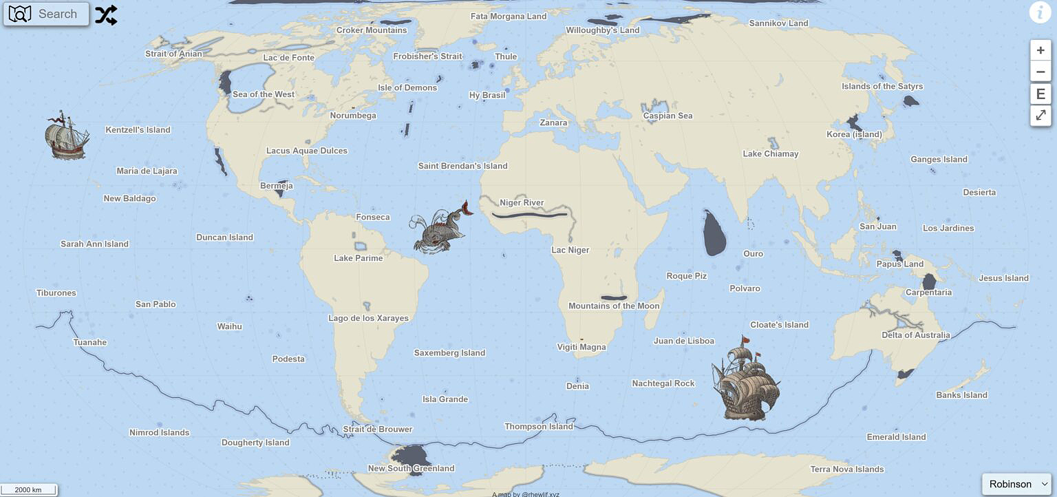
3232Explore the Fascinating History of Imaginary Lands With This Interactive Map
https://explorersweb.com/map-myths/
https://explorersweb.com/map-myths/#respondTue, 03 Dec 2024 17:33:45 +0000https://explorersweb.com/?p=100582
Every exploration buff knows that made-up geography often appeared on ancient maps. The most famous example is that of Atlantis, a myth that originated with Plato and persisted on maps well into the European Renaissance. But as explorers increasingly sought out the world just over the horizon, they brought back tales — often second or third-hand — of other wild lands.
Mapmakers often plopped these tales into existing blank spaces, sometimes as a bit of artistic flourish and sometimes because they legitimately believed the stories.
A website called Map Myths has turned these mythical lands and geographical features into a surprisingly thorough interactive experience. And it's a must-visit. Users can click on the names of these mythical spots for capsule explanations of how they originated, how they were dispelled, and sometimes who went looking for them. Users can also view the historical maps where the myth in question appears.
Here are a few of the most interesting examples.
The main page and interface of Map Myths. Photo: Screenshot
Wishful thinking
Sometimes, a geographical feature ends up in a mapmaker's visual lexicon through the sheer power of wishful thinking.
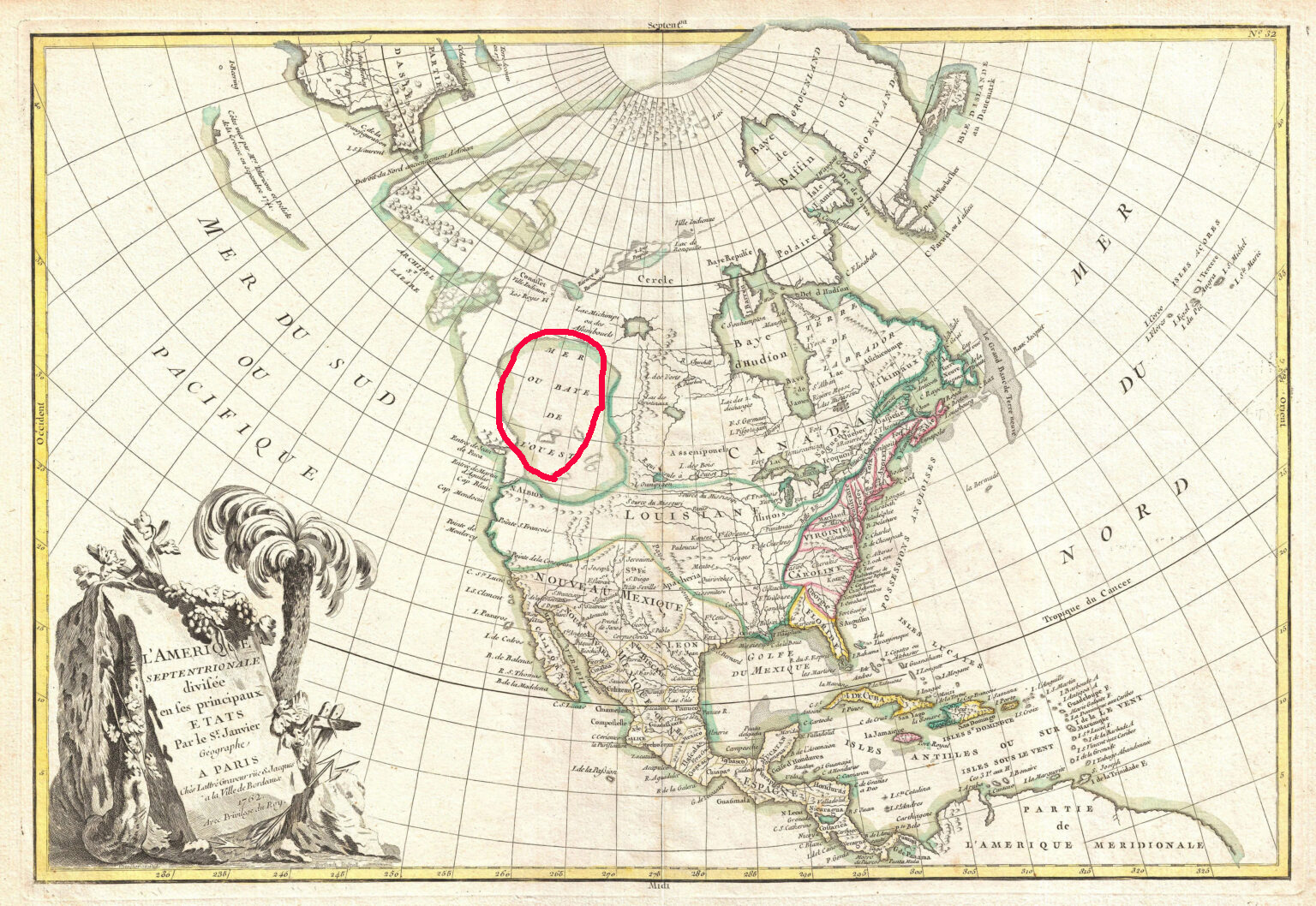
When 16th-century explorer Giovanni da Verrazano peered over modern-day North Carolina's Outer Banks islands, he laid eyes on Pamlico Sound. The sound is the largest lagoon on the United States' eastern coast, so when Verrazano couldn't see the other side of it, he optimistically assumed it was the Pacific Ocean.
This notion was dispelled quickly as more and more colonists and explorers charted the New World, but the idea of a great "Sea of the West" hung on long after Verranzano's day.
A map from 1762 showing the 'Sea of the West.' Photo: Wikimedia Commons
Partly, that's because a navigable, coast-to-coast water route through North America would pay huge economic dividends to whichever power discovered it. The idea was just too lucrative to let go. According to Map Myths, cartographers included the "Sea of the West" on more than 200 maps during the 18th century.
James Cook's exploration of the Pacific Northwestern coastline diminished the chances of the Sea being real. Lewis and Clark weren't expecting to find it during the Corps of Discovery's journey westward. But Thomas Jefferson — then President of the United States and the expedition's progenitor — would have been more than happy if they did.
Western Europe hopes against hope
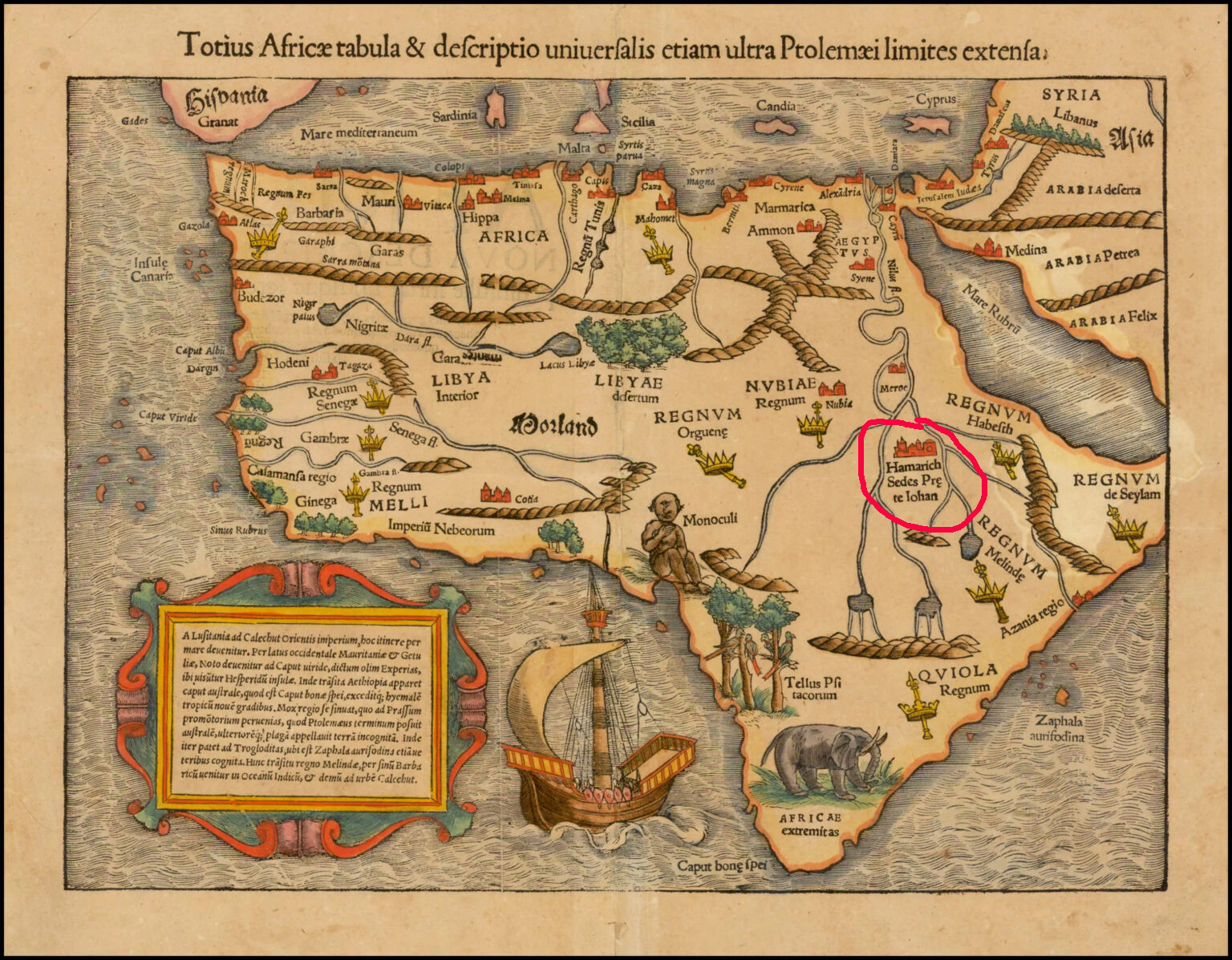
The legend of Prestor John, a powerful and saintly Christian king living somewhere in the Far East, first arose in the mid-1100s AD. By the time European crusaders found themselves outmatched by Islamic military tactics in the Crusades, Prestor John was more than a fairy tale in the minds of many. He or his descendants were a much-hoped-for fighting force that could pressure Islamic armies from a second front.
As it turned out, such a fighting force did arrive to smash into the Islamic world, but it turned out to be the Mongols. Under Genghis Khan, the Mongols swept into Persia in the early 1200s, eventually sacking Baghdad. The unstoppable Mongols effectively ended the powerful Abbasid Caliphate, a turning point in human history if ever there was one.
This 1550 map shows 'The Kingdom of Prestor John' at the confluence of the Nile sources. Photo: Stanford University Libraries
It eventually became apparent that Prestor John's legendary kingdom must lie elsewhere, so mapmakers began placing it around modern-day Ethiopia. Christianity in Ethiopia dates back to the fourth century AD, and the region was far enough removed from Western Europe to maintain a sense of mystery. It took another 200 years or so for Prestor John's imaginary kingdom to disappear from African maps.
Almost every map created during the Age of Exploration was speckled with phantom islands.
It's hard to pinpoint the origins of many of these mythical islands — usually a blend of legends and sailors' tales filtered through time and many mouths. But in at least one case, we can look back at a true story to see the genesis of a phantom island.
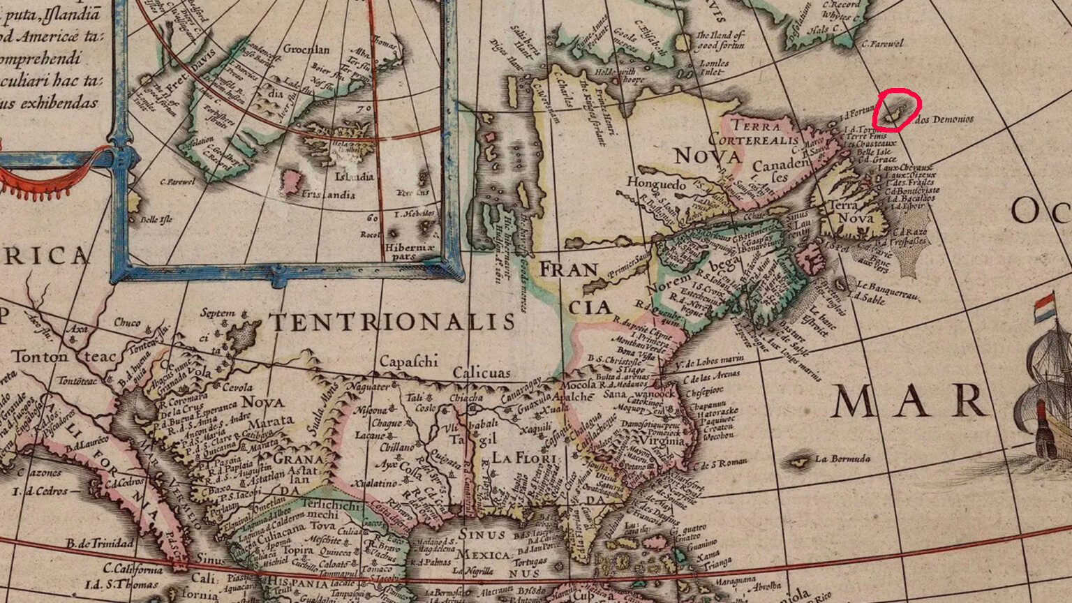
In 1542, Jean-François de La Rocque de Roberval, a French nobleman and privateer, set out for New France (modern-day Quebec) to take up his post as the Lieutenant General of the colony. Accompanying him was Marguerite de La Rocque de Roberval, a young woman and relative of the freshly appointed colonial official. Marguerite took a lover on the voyage, and this behavior so scandalized the privateer that he marooned Marguerite, her servant, and her lover on an "island."
The Isle of Demons is visible on this map from the early 1600s in the upper right-hand corner. Photo: Public Domain
Eventually rescued
Marguerite later gave birth under these circumstances, but her baby, her lover, and the servant all died during the years they were marooned. Marguerite was eventually rescued by Basque fishermen.
Once she reached Europe again, Marguerite's tale became widely known. Mapmakers had already been including an "Isle of Demons" on maps of the Newfoundland coastline, noting it as a spot where all manner of hardships might befall unwary sailors. With the young women's tales of privations firmly lodged in the public imagination, the phantom island quickly became the setting for the marooning. In reality, it was most likely a region around Harrington Harbour, Quebec -- not an island at all.
Still, the Isle of Demons continued appearing on maps well into the mid-1700s.
You can easily — and happily — spend a whole afternoon exploring the mythical kingdoms, islands, and mountains inked onto the maps of yesteryear. Check out Map Myths here.
]]>https://explorersweb.com/map-myths/feed/0Exploration Mysteries: The Lost Continent of Argoland
https://explorersweb.com/exploration-mysteries-argoland/
https://explorersweb.com/exploration-mysteries-argoland/#respondSat, 12 Oct 2024 13:04:04 +0000https://explorersweb.wpenginepowered.com/?p=90257
Can a continent disappear? Many cultures have stories of vanishing islands or cities swept away by tidal waves. But is there truth to any of these legends?
Our continents have undergone tumultuous periods of shifting, converging, diverging, and subducting. With these geological processes, continents broke apart. Occasionally, we find remnants of ancient continents. Scientists have been searching for one of these, called Argoland, for decades. They might have finally found it.
Paleocontinents
When we talk about submerged continents or lands, we refer to continental crust in our oceans. These landmasses could be the source of "lost land" stories in numerous cultures, such as Atlantis, Lemuria, and Thule.
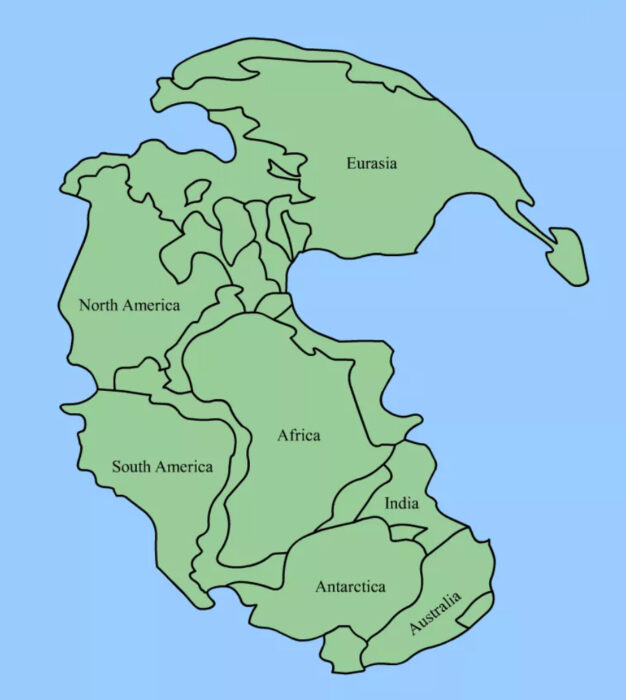
Landmasses from Earth’s distant past are split into cratons, supercratons, microcontinents, continents, and supercontinents. Gondwana, Laurentia, Pangea, and Rodinia were supercontinents. Broken apart by plate tectonics, they became continents, which sometimes broke into smaller microcontinents.
We have found microcontinents and cratons around the globe. Scientists identified Madagascar and Seychelles as microcontinents of the Gondwana supercontinent. Other islands, like the Azores and Socotra in Yemen, are pieces of Pangea.
Plate tectonics map. Photo: M.Bitton
Some of Earth's early landmasses were gradually submerged, others subducted -- slipped below -- into the Earth's mantle. Others pushed up to form islands and mountains.
What is Argoland?
Argoland was a continent that purportedly split from northwestern Australia before drifting northwest toward Southeast Asia. Its disappearance left a void in the ocean off the northwestern coast of Australia. No one definitely knew where it went. In theory, it could have settled under Indonesia and Myanmar. Argoland existed during the reign of the dinosaurs and was supposedly 4,800km long and the width of the United States.
Normally, when a landmass moves, it leaves behind a sort of signature. This signature is usually underwater mountain ranges, fossilized wildlife, and other large areas of land underwater. But Argoland did not leave obvious clues.
The search for Argoland
Eldert Advokaat and Douwe van Hinsbergen from the University of Utrecht are key figures in the search for Argoland. They believe that the continent split, creating an oceanic basin called the North Australian Basin or Argo Abyssal Plain. It is 5,730m deep and possesses some magnetic anomalies. For Advokaat and van Hinsbergen, this indicated that something once occupied this space. They launched their search in 2017.
Van Hinsbergen discovered Greater Adria in 2019. This continent broke off from North Africa, splintered into multiple pieces, and settled in the Mediterranean. Pieces can be found all over Europe, including the Balkans, Alps, Anatolia, and Iberia.
Meanwhile, Advokaat had been documenting rocks on the Indonesian island of Sulawesi, believing it held the key to unlocking a missing part of our geological history.
They believe Argoland began to break away some 300 million years ago when Gondwana was still a supercontinent. It finally broke away from northwestern Australia 155 million years ago during the Late Jurassic Period.
A reconstruction of Argoland. Photo: Utrecht University
Far-flung fragments
Remnants of Argoland lie in Southwest Borneo, Greater Paternoster, East Java, West Burma, and Mount Victoria Land. Advokaat and his team excavated these areas.
Advokaat and van Hinsbergen realized that bits and pieces of Argoland were hiding in layers of rock that differed in age, making it hard to distinguish. They had expected to find a single buried landmass. Instead, rock from different ages was muddled together.
In their study, Advokaat and van Hinsbergen argue that Southeast Asia includes relics of a major continent. As plate tectonics shifted, upheaved, and subducted pieces of the Earth's crust, the process created a deformed, long-lived belt of the Earth's crust called an orogen. This orogen formed during a long, chaotic period of 100 million years.
By evaluating the western and northwestern Australian margins and formations throughout Myanmar, Indonesia and Malaysia, the team managed reconstruct the tectonic movements of Argoland. This reconstruction showed Argoland's trajectory for Southeast Asia as the Northwest Australia Margin was subjected to an eons-long period of ocean spreading, continental extension, and then subduction. As a result, pieces of land were uplifted and lie within those Southeast Asian islands.
Chaotic and messy
Not all continents which separate make such a clean break from South America and Africa, says science writer Cassidy Ward. In the case of Argoland, things got chaotic and messy. Therefore, Argoland was not a large, solid landmass but a chain of islands, an archipelago. The pair have affectionately named it "Argopelago." This archipelago formed as the bigger landmass was breaking off of Australia.
The continent of Great Adria suffered a similar fate. It fragmented so much that you can find pieces all the way from the Iberian Peninsula and the Mediterranean to Western Asia! The painstaking search for remnants lasted more than a decade. Greater Adria supposedly spun and collided into other landmasses, sending a thick chunk of the Earth's crust into the mantle. The rest you can find in strips in the Pyrenees, Occitania, the Alps, Anatolia, and the Caucasus. It was supposedly the size of Greenland at one point.
More continents await
The search for ancient continents never stops. In 2017, scientists discovered a lost continent called Mauritia beneath the surface of Mauritius. It lay between India and Madagascar on Gondwana before the supercontinent split up. After the separation, Mauritia broke into even smaller pieces which can be found in Mauritius, Réunion and the Saya de Malha Bank. Researchers detected it by analyzing the zircon crystal deposits in Mauritius, indicating that they originated from continental crust. There was also a gravitational anomaly which usually signals a much larger, hidden landmass.
As of 2023, geologists completed mapping Zealandia, a land that broke off of Gondwana over 80 million years ago. Most of it is underwater. New Zealand is part of this massive landmass.
Conclusion
After the discoveries of Argoland, Greater Adria, Zealandia, Mauritia and other ancient continents, it is most likely that others remain hidden. These studies have given us leads for a more thorough search. We have better indicators now, like the zircon crystals and magnetic and gravitational anomalies. We also have a firmer understanding of the land's movements.
Many submerged lands turned out to be more fragmented and ribbon-like than predicted. Therefore, scientists need to put aside their preconceived notions of what the Earth used to look like in order to find more of our geological past.
]]>https://explorersweb.com/exploration-mysteries-argoland/feed/0Watch: Giant Hydrothermal Explosion Shuts Down Part of Yellowstone National Park
https://explorersweb.com/watch-yellowstone-eruption/
https://explorersweb.com/watch-yellowstone-eruption/#respondTue, 23 Jul 2024 20:53:17 +0000https://explorersweb.com/?p=97595
BY RACHELLE SCHRUTE
A massive explosion near Old Faithful has temporarily closed parts of Yellowstone National Park. A visitor filmed the hydrothermal eruption, which sent tourists fleeing the boardwalk at Biscuit Basin.
The National Park Service released the following information:
On Tuesday, July 23, at about 10:19 a.m., a localized hydrothermal explosion occurred near Sapphire Pool in Biscuit Basin, located just north of Old Faithful.
Biscuit Basin, including the parking lot and boardwalks, are temporarily closed for safety reasons. The Grand Loop Road remains open.
No injuries were reported, and the extent of damage is unknown at this time.
Park staff and staff from USGS will monitor conditions and reopen the area once deemed safe.
No other monitoring data show changes in the Yellowstone region. Today’s explosion does not reflect a change in the volcanic system, which remains at normal background levels of activity.
]]>https://explorersweb.com/watch-yellowstone-eruption/feed/0Old Maps Online: A Gateway to Hours of Historical Exploration
https://explorersweb.com/old-maps-online/
https://explorersweb.com/old-maps-online/#respondMon, 24 Jun 2024 23:23:11 +0000https://explorersweb.com/?p=96802
History and geography already make excellent bedfellows, but OldMapsOnline.org has taken the alliance one step further. The website is 50% map room of the Royal Geographical Society, 50% British Museum, and 100% awesome.
Here's why. OldMapsOnline.org combines a map of the world with a sliding timeline. With a few tweaks of the computer mouse, you can watch history unfold before your eyes.
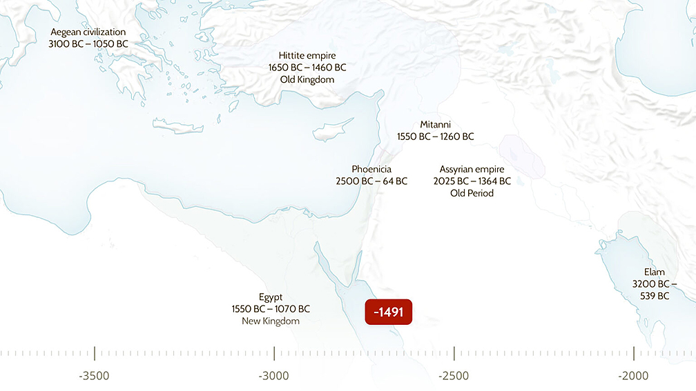
Take Europe, Northern Africa, and Central Asia, for instance. With the site's default "Regions" tab active, you can start way back in 2,000 BC (or further) and scroll forward, watching as the Aegean, Sumerian, and Indus civilizations become Greecian, Assyrian, and Gandhāran, respectively. Keep scrolling and watch the Macedonians, Romans, and Babylonians arise — Egypt, of course, sticks around through the millennia (because that's how Egyptians roll).
Using the interface, it's easy to tell at a glance where ancient civilizations first took root — and when they crumbled, conquered, or collapsed. Photo: Screenshot
And whatever you do, don't take your eyes off the Goths, Visigoths, Ostrogoths, and Germanic peoples. As you probably know, their moment is coming.
Fans of more modern history will be just as enthused. If you're curious about what, where, and when the Holy Roman Empire turned into the modern nation-state of Germany, this site is your huckleberry.
But wait, there's more
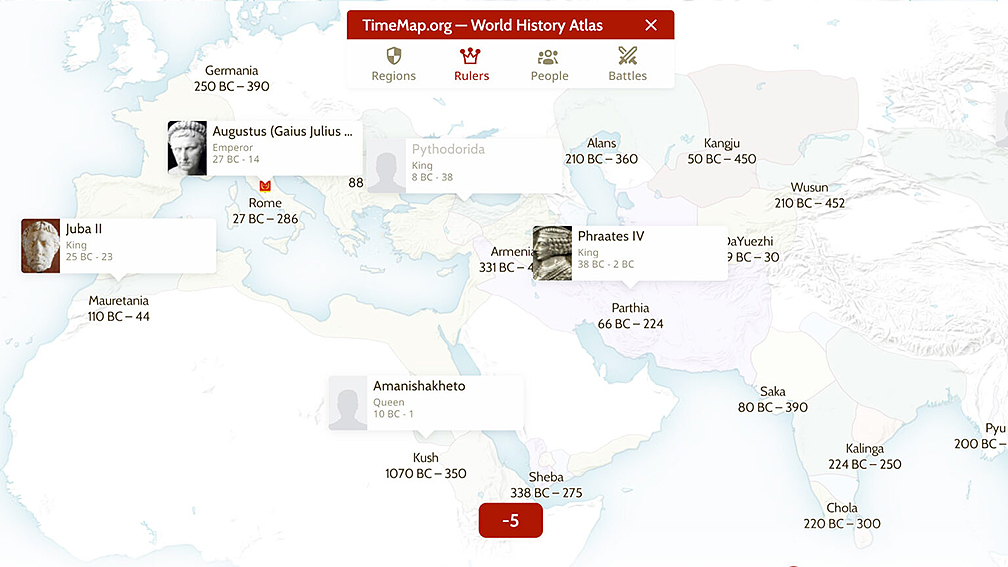
And that's just the "Regions" function. The site also has tabs for "Rulers," "People," and "Battles." Swapping back and forth between the tabs and rolling the slider back and forth is bound to be addictive to all but the most history-resistant dilettante. The tools are especially useful for students, journalists, and anyone else with more scholarly interests. It was hard not to get distracted even while writing this story!
The 'Rulers' tab makes it a cinch to compare the reigns of world leaders from across the ages. Photo: Screenshot
That's because the interface is so clean and easy to interact with — and because of the inclusion of a Wikipedia interface. See a name you don't recognize? Click it and prepare to spend the next three hours going down a Wiki wormhole.
An intuitive Wikipedia interface? Well, there goes my workday. Photo: Screenshot
As a final touch, you can choose from a selection of old maps to overlay against the base interface, then use the "compare" tool to see how things have changed over time. And even better, the site has a Chrome extension that allows you to add suitable maps to the database.
As you'd expect from something that is both relatively new and somewhat crowd-sourced, OldMapsOnline isn't perfect. North America in the 1700s, for instance, doesn't currently show the traditional lands of the many native people who called the continent home at the time (only the Sioux and Iroquois). But we can foresee a near future where folks who run the site fix that.
]]>https://explorersweb.com/old-maps-online/feed/0Unraveling the Mystery of the Late Triassic's Two-Million-Year Rainy Season
https://explorersweb.com/two-million-year-rainy-season/
https://explorersweb.com/two-million-year-rainy-season/#respondThu, 28 Mar 2024 15:52:34 +0000https://explorersweb.com/?p=94004
The forty days and nights of rain during the Biblical flood does not compare to what happened in the late Triassic, over 234 million years ago. Earth was hot and humid, and the rain lasted two million years. An umbrella -- and not just one ark but a fleet of them -- would have been recommended.
The Triassic Period featured several major upheavals in the climate, landscape, and life on Earth. One of the least known is the Carnian Pluvial Event (CPE). Not surprisingly, the two million years of rain changed the planet forever.
Before the Great Rain
What was Earth like before this endlessly steady rain? At the time, the main landmass was Pangea. Essentially, it was a gargantuan, barren desert stretching from the North to the South Poles. Plant life was unimpressive, characterized by small desert plants dotted across the sands.
Rainy seasons were short and infrequent. Mountain ranges around the interior prevented rain from penetrating regularly. Only the coastlines had their share of water. Earth was 10°C warmer than today and seas were 47°C -- much hotter than bath water.
Animal life consisted of very ancient forms of insects, reptiles, mammals, and the earliest dinosaurs. Reptiles ruled while small dinosaurs were the awkward new kids on the block. Conditions weren't optimal for them. The Earth also had one main ocean called Panthalassa, in which there lived ammonoids, gastropods, sponges, corals, and other species.
Pangea. Photo: Florida Museum
This all changed when what started as a few dark clouds and drops of rain soon turned into a two-million-year monsoon.
Strangely enough, this event has rarely been talked about until now, although evidence about it has circulated since the 1970s. When it comes to mass extinction events, scientists have always focused on the "big five": Ordovician-Silurian, Devonian, Permian-Triassic, Triassic-Jurassic and End-Cretaceous. However, this one seems to have escaped their notice for quite some time.
Some researchers blame the event's odd chronological position for its neglect. It did not happen at the beginning or end of a major geological era, like they often do. It seemed to have occurred at a very random time. Was it random, though?
Volcanism at work?
The main theory for this long period of rainfall is that a series of powerful volcanic eruptions around Alaska and British Columbia sent massive amounts of carbon dioxide into the atmosphere. This caused a long period of global warming and acidification of the oceans. It created great humidity, which inevitably led to extreme rainfall.
These volcanoes would have been powerful enough to change the water and carbon cycles, altering the climate forever. Many species died out as a result, including one-third of all marine animals. It's important to note that the rains were in intervals, not in one continuous, neverending deluge.
“It’s like charging a massive battery," explained geoscientist Jacopo Dal Corso, who has led research into the topic. "A ton of cooling high in the atmosphere and a ton of evaporation and heating near the surface…[is] going to cause an enormous storm.”
Some palaeontologists suggest that a new mountain range caused all this trouble due to pressure changes between land and the ocean. However, most scholars believe that the volcanism theory is more plausible.
Evidence
The Carnian Pluvial Event was only discovered in the 1970s. Geologists Schlager & Schollnberger were studying rocks in Austria's Northern Limestone Alps when they noticed a peculiar and sudden layer of dark grey siliciclastic rock within the previously consistent carbonate rock record.
They dated it to 234 million years ago. This rock was not consistent with Pangea's hot, dry climate. Rather, this type of rock typically showed up in very wet areas or those with an abundance of water.
Other deposits from this time started popping up all over the globe. In southwest England, geologists found it embedded in layers of red sandstone. It also turned up in Israel, Italy, and Utah, in the U.S.
Illustration of a reptile during the CPE. Photo: JORGE GONZALEZ/NHMU
Other indicators of a deluge included the presence of amber, coal, ancient rivers and lakes with fossilized plant debris, and a white powdery clay called kaolinite. Additionally, fossilized pollen and spores found in rocks from the Carnian period also indicated a humid climate and hot temperatures.
Because of its recent discovery and the difficulty in finding data over the years, some geologists refer to the CPE as the "hidden extinction."
After the rains...
Though climate change from human activity is considered undesirable nowadays, this ancient period of climate change did the world a lot of good. The planet saw a drastic acceleration of the major cycles, including the carbon and hydrological cycles.
Dinosaurs thrived, and the weather regulated itself more. Reptiles began to decrease as towering conifers and other large plants replaced their food supply (ground vegetation). Dinosaurs fared well with the larger plants. The ancestors of modern animals such as turtles and crocodiles emerged alongside them. The newly acidic seas led to the growth of plankton and coral reefs.
Did the rains stop? Yes, this period of rain and its subsequent flooding dissipated and global temperatures settled down into a less intense, cooler climate. Pangea became a desert again, but it was a different-looking landscape. The accelerated hydrological cycle caused rampant erosion and weathering. The soil from which plants grew changed radically from a carbonate base to much darker and more fertile sediment. The air shifted from its hot, dry state to a more humid one.
When the Late Triassic closed and the Jurassic period began, Pangea started breaking up and new oceans began to form. This created even more humidity, turning the climate subtropical. Deserts became tropical forests.
After the CPE, rain also regulated itself. It instead fell regularly at an average of 1-3 metres annually in more steady, seasonal intervals that did not last that long, especially not as long as two million years.
Essentially, this event was the beginning of our modern world, in the geological sense. The environment we have today, the climate, and our flora and fauna took hold after the CPE.
Conclusion
The climate continued to change after the CPE. More extinctions and reshaping of the environment occurred. The timing of the emergence of the dinosaurs and the CPE is no coincidence. This event was crucial for their domination in the Late Triassic. Scientists are happy to include yet another mass extinction in their line-up of Earth's history. While this event is not as substantial and violent as the "big five," it still played a pivotal role in birthing our modern world.
]]>https://explorersweb.com/two-million-year-rainy-season/feed/0Japanese Earthquake Adds 250 Meters of Coastline
https://explorersweb.com/japanese-earthquake-raises-coastline-250-meters/
https://explorersweb.com/japanese-earthquake-raises-coastline-250-meters/#respondTue, 16 Jan 2024 08:08:51 +0000https://explorersweb.wpenginepowered.com/?p=92142
The massive earthquake that hit Japan’s Noto Peninsula on Jan. 1 has had a drastic effect on the peninsula's coastline. Satellite images show that the quake has moved the coastline further into the ocean.
Inhabitants along Japan's western coastline felt the 7.6 magnitude quake on New Year's Day. One-meter waves crashed into the Ishikawa prefecture on Honshu Island, and in Akasaki they reached 4.2m.
The government released tsunami alerts across the region. Thousands of houses lost power, and several buildings collapsed. The earthquake killed 213 people and displaced 26,000.
The earthquake that struck Japan’s Noto peninsula on Monday was so strong that the coastline has moved up to 250 meters offshore due to significant land uplift. pic.twitter.com/XpxBMLRTUU
Recent images show the force of the quake. At ten points along the coast, the coastline shifted significantly, as the seafloor rose above the normal water level. Besides the new beaches, there are also some trapped ports. The ports are now high and dry, and boats can't access them.
The Japan Aerospace Exploration Agency (JAXA) provided satellite imagery of the changes. Some coastal areas have risen by almost four meters. The rising land may have reduced the tsunami's impact.
A region of the Noto Peninsula in June 2023 (left) and January 2024 (right) shows coastal expansion from the earthquake. Photo: Geospatial Information Authority of Japan/JAXA
Coastal uplift can happen in two ways, both involving tectonic forces. It can occur very slowly over geological time or rapidly because of earthquakes. When a large earthquake causes vertical movement on a fault line, the land can suddenly shift upwards.
Since Jan. 1, there have been several aftershocks, and the authorities warn that further strong earthquakes could follow over the next month. Already, another 6.0 magnitude quake has added to the destruction.
The region lies at the border of four tectonic plates and an incredible 20 percent of all global earthquakes over a magnitude of 6.0 have occurred in this area. This is the strongest earthquake here in four decades.
]]>https://explorersweb.com/japanese-earthquake-raises-coastline-250-meters/feed/0Another Geographical Center, Another Bitter Fight: Three Small Towns Battle It Out
https://explorersweb.com/geographical-center-north-america/
https://explorersweb.com/geographical-center-north-america/#respondThu, 07 Dec 2023 00:41:32 +0000https://explorersweb.wpenginepowered.com/?p=89878
What is the geographical center of North America? The stakes are too high for people to agree on an answer.
What is everyone’s obsession with the center of things? We’ve tried to find the center of the Earth, the center of the universe, the center of a city, and even the center of a baseball!
Strangely, finding the center of a continent has become a competition. In a previous article, we explored the geopolitical tug-of-war for the geographical center of Asia. Here, a similar battle takes place for the center of North America between three small towns in the Dakotas.
It all started in 1918. The U.S National Geodetic Survey determined that the center of the 48 contiguous United States is 4.1km northwest of Lebanon, Kansas. It took into account the newly added states of New Mexico and Arizona but excluded Hawaii and Alaska, which were not states at that time. When Hawaii and Alaska joined, the position shifted to Belle Fourche, South Dakota. Note that this does not include Canada or Mexico.
Lebanon, Kansas, the center of the USA. Photo: Shutterstock
Balancing a cutout on a pin
In 1931, another U.S Geological Survey chose to find the center of the entire continent simply by balancing a cardboard cutout of the continent on a pin. Was this accurate? Not really, due to lack of proper technique and the limited technology of the time.
Why did they do it this way? According to some sources, a geographic center is a balance point, also known as the center of gravity. This suggests that finding this point would mean finding the center of a two-dimensional scale model.
The USGS determined the center of North America (including Canada and Mexico) was 10km west of Balta, North Dakota. The closest town to this location is Rugby, which did not hesitate to swoop in and stake a claim.
Rugby, one of the supposed Geographic Centers of North America. Photo: Tim Samuelson/Shutterstock
Despite Rugby’s small size, it quickly became an overnight tourist hotspot for travelers. The town even erected a 4.5m high monument and accompanying flags of the United States, Canada, and Mexico to strengthen its claim.
They enjoyed this status until challenged in 2015 by a bar owner who decided to play the legal game instead of the geographical one.
Bar fight
Just 160km south in Hanson’s Bar in Robinson, North Dakota, a few drunken patrons happened to have a globe on hand. They used a piece of string and a ruler to determine the center of North America. It landed on Robinson. The bar owner, who is also the mayor of Robinson, hurriedly trademarked Robinson as the center. Rugby had not renewed its trademark license for several years. It was a classic case of “you snooze, you lose.”
This turn of events led to Rugby filing a lawsuit against the mayor of Robinson. Rugby won back its title. Yet things did not stop there.
Hanson's Bar in Robinson refused to concede its coveted title. Photo: penryfamily.com
Previously, the U.S. Geological Survey stated that there was no one way of finding a geographical center. However, it suggested that one must factor in the curvature of the Earth, large bodies of water, and other subtleties.
To put all the craziness to rest, Peter Rogerson, a geographer with the University of Buffalo, published a study that determined a geographical center more accurately.
He said he “calculated the point at which the sum of squared distances to all other points in North America would be smallest -– the mathematical definition of a geographic center.”
Rogerson's argument is somewhat technical, but he used map projections to turn 3D images into 2D, then got out his protractor and started crunching distances and angles. He discovered that the real center is actually in a town called…Center. Population a mere 588, it lies 164km southwest of Rugby.
Center, North Dakota makes its pitch as the "scientific" center. Photo: City of Center
Tourism and civic pride
The fight between these nearby towns boils down to their desire to be not just another place motorists pass through. They want to be a tourist hotspot, bringing in visitors and helping secure their little town’s future, financially and culturally.
As for the answer to this age-old question: It seems to depend on whether or not you included Hawaii, Alaska, Mexico, separate islands, and other determining factors. This is why the location keeps changing.
If we parse North America today through modern geographical definitions and Rogerson’s more dependable methodology, the town of Center sounds most plausible. It would be interesting to see how this methodology applies to other continents. But clearly, the stakes are high enough that no matter where in the world it is, there will never be universal agreement.
]]>https://explorersweb.com/geographical-center-north-america/feed/0China vs Russia: The Modern Battle Over The Geographical Center of Asia
https://explorersweb.com/geographical-center-of-asia/
https://explorersweb.com/geographical-center-of-asia/#respondFri, 24 Nov 2023 19:16:07 +0000https://explorersweb.wpenginepowered.com/?p=89393
The geographical center of a place refers to the midpoint between three or more points on Earth. The main competitors for the honor of being the Center of Asia are Kyzyl, the capital of Tuva (a republic within Russia), and Ürümqi in China.
Map of Russia, with Tuva in red and Mongolia just south of it. Illustration: Wikipedia
Unfortunately, the methods of determining a geographical center are not necessarily accurate. Many variables are at play. Some researchers include bodies of water or islands. Others don't. Often, one geographer disputes another's conclusion. That's the case with the center of Asia.
History
Kyzyl is approximately 4,700km away from Moscow, near the Mongolian border. There isn't much tourism here nowadays, since Russia's invasion of Ukraine. Even before that, there wasn't much. Most tourists seeking a Mongolian experience go to the country of Mongolia itself rather than to this Russian enclave of Mongolian culture.
Mongolian culture, including Mongolian-style wrestling at the annual Naadam festival, remains prevalent in Kyzyl. Photo: Jerry Kobalenko
Historically, the area initially belonged to China and then Mongolia. In the 19th century, the Qing Dynasty government gave Russians permission to settle there. However, this small-scale settlement scheme turned into full-blown colonization, followed by a separatist movement encouraged by the Tsarist monarchy. Eventually, Tuva gained a sort of independence for a short time before the Soviet Union enveloped it. In the West, it was known mainly by philatelists for its exotic postage stamps. Currently, it is a relatively forgotten part of the Russian Federation.
The original center of Asia obelisk, replaced today by a grander version, shown in the featured image. Photo: Jerry Kobalenko
Geographical research
The story of how Kyzyl came to be the center of Asia varies. An engineer named Vsevolod Rodichev said in the 1900s that an Englishman on a mission to find the centers of all the continents determined that Kyzyl was the heart of Asia. He duly erected a monument on the property of Georgy Safyanov, an official with the Imperial Russian Geography Society. Many people thought the story was bogus, but this did not stop the Soviets from commissioning an obelisk in its honor on the banks of the Yenisey River.
In 2014, the Russians created a larger, more opulent monument in the same location to reflect Tuva's Buddhist ties. Ancient Scythian imagery also shows Chinese, Mongolian, and Russian influence.
Google Earth map of the geographical center in Asia. Photo: Far West China
Another story states that a man named Proctor placed the first monument in Kyzyl. Whether or not he was this mysterious Englishman is unclear. Supposedly, a man called Masahiko Todoriki visited the location and interviewed locals for answers. He mainly received a mixture of shrugs and dismissals. One person claimed to remember the man as an English teacher. However, the trail goes cold from there.
Rivalry with China
Russia's declaration that it held the center of Asia did not sit well with the Chinese. Their own calculations put the geographical center 700km from Kyzyl -- not coincidentally, within Chinese territory. Their method took the geographical centers of 49 countries in Asia and found that the midway point lay in Yongfeng, near the city of Ürümqi in Xinjiang.
However, these Asian countries included island states as well. Whether the inclusion was done purposefully to place the midway point in Chinese territory is unknown. The calculations are not easy to verify.
Nevertheless, the Chinese built an elaborate monument to commemorate their finding. They even decided to relocate a whole village in order to build up the spot. It includes a large gate resembling wings and an 18m high tower with four posts forming an "A" for Asia and a globe at its summit.
China's competing center of Asia monument. Photo: songyimao/Panoramio
Conclusion
The debate remains ongoing. No one has legitimized either claim. However, the answer lies in the methodology. How do you accurately find the geographical center of a place, let alone a continent? Some tried to find the centroid, or geometric center. Others proposed finding it by longitude and latitude. Still others, by using an area’s volume: In other words, giving mountains extra "weight" compared to flat land.
The United States Geological Survey states that there is no precise way of calculating these things and “no accepted definition” of a geographical center.
]]>https://explorersweb.com/geographical-center-of-asia/feed/0Books for Explorers: The Atlas of Unusual Borders
https://explorersweb.com/unusual-borders/
https://explorersweb.com/unusual-borders/#respondTue, 24 Oct 2023 00:01:23 +0000https://explorersweb.wpenginepowered.com/?p=69936
Those of us who do expeditions rely on maps for everything from sparking ideas to route planning. Most countries have clear borders, but this is not always the case. In his book The Atlas of Unusual Borders, Zoran Nikolic explores the oddities of the world's borders and how they came to be.
It turns out that around the globe, there are several border anomalies. These are potential annoyances when planning, but they are also geographical markers of historical events and political conflicts. For hundreds of years, people have fought over pieces of land. Nikolic comments that the borders we now look at are “lines giving the impression of scars left by man on the face of our planet.”
Below, a few of the border idiosyncrasies detailed within the book.
Diomede Islands: Russia-U.S.
Big Diomede and Little Diomede are part of the same archipelago in the Bering Strait. They are just four kilometers apart, and on a clear day you can see the neighboring island across the water. Despite this closeness, they fall on a border that has partly been dictated by politics but also separated by time.
The Diomedes Islands. Map: Google Maps
The International Date Line falls directly between them. Big Diomede belongs to Russia, while Little Diomede is part of the U.S. If you look out from Little Diomede, you can see another country, continent, and day on Big Diomede.
During the Cold War, all the inhabitants of Big Diomede were forced onto mainland Russia so that they did not contact their American neighbors on Little Diomede. These exiles never returned. Instead, there is now a small military base on the island. Meanwhile, just 150 people live on Little Diomede.
The Diomedes in world news
In 1987, American swimmer Lynne Cox brought the two islands to the forefront of world news. To try and ease the tension between the United States and the Soviet Union, she took on a swim to open the border between the countries.
Lynne Cox swims the Bering Strait. Photo: Openwaterpedia
Starting in Little Diomede, she swam the 4.3km across the Bering Strait to Big Diomede. As she plunged into the sea, the icy water took her breath away. "The cold was like a huge vampire pulling the heat from my body," she said later.
In just a swimsuit and cap, her body temperature plummeted. By the time she got out, her fingers were grey and her hands looked like they belonged to a cadaver.
Organizing the swim was no mean feat. The Cold War was still underway. For years, she tried to get permission to undertake the swim, but her requests to cross the border were ignored. Eventually, she decided to attempt it regardless. With 30 hours to go, two Soviet ships appeared in the Strait. The U.S. responded by sending fighter jets. Twenty-four hours before her swim, she finally received permission from President Gorbachev. In the end, a Russian support vessel accompanied her and she was met by a Russian welcoming party.
In a later meeting with President Reagan, Gorbachev raised a glass to her and commented, "She proved by her courage how close to each other our peoples live."
Pheasant Island, France/Spain
Pheasant Island is a small, uninhabited piece of land in the middle of the River Bidasoa. It is co-owned by two countries, France and Spain. It is one of the most peculiar border territories out there. Rather than share the island, each country owns it for six months of the year.
For the first half of the year, it belongs to the Spanish city of Irun. Then it switches hands to the French town of Hendaye. Since the agreement came into place 350 years ago, the small island has changed nationality over 700 times.
Pheasant Island falls on the border between Spain and France. Map: BBC
Now shut off to visitors, it was once an important neutral territory and home to a landmark event between Spain and France. In 1659, the island hosted the three-month negotiation that ended in Treaty of the Pyrenees, which ended the Franco-Spanish War.
A year later, a Royal wedding took place on the same spot to mark the occasion: French King Louis XIV married Maria Theresa of Spain.
Mount Athos: Greece
Mount Athos sits on the Athos Peninsula in northeastern Greece. It is an autonomous state under Greek sovereignty. While other countries do not contest ownership, Mount Athos has a unique idiosyncrasy: It is the only territory on Earth with an all-male population.
Simonos Petras Monastery, Mount Athos. Photo: Shutterstock
In mythology, there are two stories about this mysterious mountain. The first starts with Athos, a Thracian giant. During the battle between the gods and the giants, he was going to throw a massive rock at Poseidon when it slipped from his hands and crashed into the sea. Thus, Mount Athos was formed.
The second story tells why the port is called Daphne. Ironically, for what is now an all-male territory, it was named after Daphne, daughter of the Arcadian King. When Apollo fell in love with her, Daphne ran to away to the island to resist temptation and protect her virginity.
Priests and monks began to settle on the peninsula at the end of the 8th century. Now it is home to 2,000 monks who live within its 20 monasteries. Though it has always been considered Greek, it has been contested a number of times. During the Ottoman Empire, it fell to the Turks, but the Greek military later emancipated it.
Ensued a long period of tension with Russia, which questioned the sovereignty of Athos. After the First World War, it was formerly declared part of Greece. Surprisingly, during World War II, though the Germans occupied Greece, Hitler left this tiny section of land alone.
Mount Athos. Map: Google Earth
No females, except chickens and cats
It is possible to visit Mount Athos, but there are two strict rules. You must have a permit and you must be male. It is the only place in the world that bans women from entering. The rule does not just apply to humans. They try to exclude females of any species. The only exceptions are cats and chickens.
This explicit rule makes recent discoveries even more mysterious. In 2019, construction workers uncovered a number of remains underneath a Byzantine Chapel. Anthropologist Laura Wynn-Antikas was brought into study them.
"Bones don't lie," she told The Guardian at the time. "They will tell you how a person lived and perhaps how they died."
A number of the bones were so small they had to be female, she said. The bones were clearly part of a second burial. They had been moved to the site from somewhere else.
The monastery that owns the chapel is equally intrigued by the mystery and has suggested further analysis to uncover the truth. Who is the mystery woman buried on a mountain that has been home to only men since the eighth century?
Deep in the forests of southeastern Siberia, the Patomisky Crater is a mysterious mound of shattered limestone that protrudes from the hillside vegetation. It has no clear origin. It changes shape, and rises and falls as the years go by. Is this thing alive?
Background
The indigenous group of the Irkutsk region, the Yakut, believed that this area is cursed. Supposedly, illness and death followed those who dared to venture there. A modern expedition led by geologist Eugeny Vorobiev seemed to substantiate this when Vorobiev dropped dead, presumably of a heart attack.
In 1949, a Russian geologist Vadim Kolpakov became the first outsider to come across it. According to The Siberian Times, the astonished Kolpakov described it as "a perfectly shaped mount the size of a 25-story building with a chopped-off top sitting in the middle of the woods."
Paradoxically, he also thought that it was "an archaeological artifact" but "not the work of a human." Kolpakov wondered whether it was of volcanic origin or even a top-secret creation of Stalin. Locals named it Patomskiy Crater, after the nearby Patom River.
Photo: The Siberian Times
Apart from a couple of articles on Russian websites, information on the crater is somewhat scarce. This is due to the lack of funding for scientific expeditions. Currently, we have to deal mainly with theories.
Characteristics
The oddity earned its nickname, "Fire Eagle's Nest," from its shape: a cone of grey, shattered, limestone with a spherical mound in its center. It is 40m high and 160m in diameter, and the center mound measures 12m high. Somehow, scientists have determined that it weighs over a million tons. It also contains some magnetic anomalies and possesses low levels of radioactive strontium and uranium. As for its age, Siberian researchers believe that it is a mere 350 years old.
It tends to change shape slightly over the years, which scientists have trouble explaining.
Theories
The million-dollar question is: who or what created it? Right now, the leading theories of volcanic, geological, or meteoritic origin are competing for supremacy.
The meteorite theory held traction in academic circles for a while. It suggests that a meteor smashed into the Earth and opened up a long-suppressed gas pocket. In order to create this oddly shaped crater, the object must have been cylindrical. Some have linked this theory to the Tunguska Event but since the Tunguska meteor strike happened in 1908, the dates don't match. This crater came long before.
The site Russia Beyond claims that scientists concluded that the Patom Crater was formed by a phreatic (volcanic) explosion, similar to Krakatoa. Kolpakov himself first thought that the crater was a volcano.
The crater at ground level. Photo: The Siberian Times
In 2015, a special conference studied the crater's origins and suggested that magma could have created steam and immense pressure, causing explosions within the rock.
Tree ring analysis picked up possible evidence of nuclear influences. The rings start to get narrow, and the vegetation around the crater experiences abnormal growth spurts which many associate with radiation. One study discovered that many of these trees fell in 1841.
The nuclear testing theory
Was this perhaps a site where nuclear experimentation took place? Siberia's remoteness made it a perfect spot for all kinds of Soviet activities, from penal colonies to energy production. The Cold War saw an exponential increase in secret nuclear testing. Or was it a result of a meteor impact that carried radiation?
The combination of radiation and meteor activity sounds quite plausible and would explain the tree ring anomaly. However, the radiation levels are not high enough to have caused the fallen and broken trees nearby.
Dmitry Demezhko from the Institute of Geophysics believes that geology and volcanism are working together under the surface here. He proposes that the crater came about when an underground channel forced molten rock upwards. A constant freeze-thaw cycle ultimately caused the rock to break.
The least likely theory is that the crater was formerly a secret uranium mining operation from Stalin's days. It would not be the first time that this dictator hid programs away from the public. Perhaps no one dared to go there, and the fearful legacy of this dictator hindered further study on the site.
A small community of conspiracists believe that forces beyond our earthly understanding -- UFOs, supernatural creatures, ancient civilizations -- created this structure. Local legends and the coincidental death of that researcher catapulted such theories into the spotlight.
Conclusion
Most likely, the Patomskiy Crater formed from a combination of geomorphological and volcanic processes. Shifting levels in pressure, water, and other chemicals can explain the changes in shape. While the meteor theory does have weight to it, this doesn't add up in other ways. We need to do more digging, literally, to learn more.
Reports of flashing blue lights near Agadir, Morocco during the major earthquake that wracked the city earlier this month has refocused attention on a long-pondered phenomenon.
What are “earthquake lights?” They’ve been around for centuries, but we still don’t know. Broad speculation and ongoing study, facilitated especially by smartphone footage, resulted from the recent event.
Early articles on the Morocco earthquake lights, or EQLs, sought to dispel the (maybe predictable) theory that UFOs or UAPs caused them. Misinformation hazards occurred.
Prolific efforts at scientific explanation were next. In footage captured shortly before the 6.8 magnitude struck Morocco, killing 2,800 according to the latest estimates, blue lights flicker in the night sky.
Like switching on a battery
Sudden discharges of electricity are byproducts of fracturing rocks, scientists point out.
“Prior to earthquakes, huge volumes of rock — hundreds of thousands of cubic kilometers of rocks in the Earth’s crust — are being stressed and the stresses are causing shifting of the grain, the mineral grains relative (to) each other,” Friedemann Freund, a prominent EQL researcher, told CNN.
“It’s like switching on a battery, generating electrical charges that can flow out of the stressed rocks into and through unstressed rocks. The charges travel fast, at up to around 200 meters per second,” he explained in a 2014 article for The Conversation.
Freund’s claims amount to theorizing. Seismologists have not reached a consensus on the mechanism that causes these lights — only that, as retired U.S. Geological Survey geophysicist John Derr told CNN, they are “definitely real.”
Reports date back to the 1600s
A 2014 paper by Derr and a group of colleagues traced the lights to a relatively rare type of earthquake. Instead of occurring near tectonic plate boundaries, like most earthquake events, the lights tend to appear in association with tremors that take place far from plate boundaries.
“Intraplate faults are associated with just 5 percent of Earth's seismic activity, but 97 percent of documented cases of earthquake lights,” said a press release issued in conjunction with the study.
The research looked at 65 documented cases dating back to the 1600s.
Another common factor it identified among EQL was earthquakes greater than 5.0 in magnitude. It also described the typical appearance of EQL.
“The EQL varied in shape and extent, though most commonly appeared as globular luminous masses, either stationary or moving, as atmospheric illuminations or as flame-like luminosities issuing from the ground,” according to the release.
Robert Theriault, a geologist with Quebec, Canada's Ministry of Natural Resources, co-authored the study. He thinks EQL could hold keys to the future of predicting earthquake events.
“Earthquake lights as a pre-earthquake phenomenon, in combination with other types of parameters that vary prior to seismic activity, may one day help forecast the approach of a major quake," he said.
Early in its history, long before the dinosaurs, Earth was an unrecognizable, hostile place. Why? There was no air. We could not breathe or exist. But thanks to a little thing called bacteria, we are now able to survive.
According to the U.S. National Park Service, stromatolites were “the dominant life form on Earth for over two billion years and are thought to be primarily responsible for the oxygenation of the atmosphere.”
Stromatolite patterns. Photo: Paulo Afonso
The Age of Bacteria
A couple of billion years ago, the Earth entered what is called the Age of Bacteria. While that sounds slightly odd, this crucial moment in our geological story was responsible for life itself; oxygen. Thanks to these organisms, Earth’s atmosphere increased from an inhabitable 1% oxygen to 20%.
Today, stromatolites show as rare sedimentary rock structures. The term is derived from Greek, meaning “layered rock.” They are created by cyanobacteria, which need sunlight to photosynthesize. As they receive that energy, the cyanobacteria create a sticky substance that binds particles together. This process repeats until it forms multiple layers in a “microbial mat.” Over time, this hardens from precipitating calcium carbonate. They are considerably softer than most rocks.
Stromatolites at Port Epworth, in Canada's Northwest Territories. Photo: Jerry Kobalenko
The oldest life on Earth
Stromatolites are colonial organisms and are the oldest life on our planet. They still, surprisingly, exist today. In the 1970s, individuals found stromatolites in a closed asbestos mine. This showed that stromatolites not only occur naturally but also through human activities.
They take various shapes, from columns to stumps and cones. Often they resemble gigantic cauliflowers or cinnamon buns. Some species are spongy while have a smoother surface. If you cut one open, they show endless layers in zigzags and wave-like patterns. The changing axes are due in part to the changing seasons, as the bacteria orient to the sun.
They can grow up to two meters high but at an agonizingly slow rate of 0.4mm annually. It takes thousands of years for a colony to gradually calcify into rock.
These living fossils take on a brownish-grey color but also usually have a green or blue hue due to algae on their surface. You find them in aquatic settings in both salt and freshwater. Because cyanobacteria can survive in harsh conditions, stromatolites can thrive in hyper-saline environments.
They are related to thrombolites, which are also colonies of microorganisms. Stromatolites and thrombolites grow by a similar process, but thrombolites have random patterns rather than layers. Both thrive in Western Australia, Argentina, Mexico, Turkey, and Canada.
Once existed on Mars?
Stromatolites tell us a great deal about Earth’s history but could also possibly indicate life on other planets. Scientists suggest they might have once existed on Mars. They believe that Mars could have had an early beginning like Earth, with a carbon dioxide-rich atmosphere.
As with most phenomena in the natural world, they are under threat. People walk on them, vandalize them, and touch them too much. This can lead to premature erosion and disintegration. Stromatolite reefs in Australia have already reported an increase in phosphorus in the water, which can kill their growth. To preserve these ancient fossils, look but do not touch.
]]>https://explorersweb.com/natural-wonders-stromatolites/feed/0This Strange Iceland Shopping Center Straddles Europe and North America
https://explorersweb.com/this-strange-iceland-shopping-center-straddles-europe-and-north-america/
https://explorersweb.com/this-strange-iceland-shopping-center-straddles-europe-and-north-america/#respondSun, 03 Sep 2023 15:34:53 +0000https://explorersweb.wpenginepowered.com/?p=76762
Iceland is where North America meets Europe. The Mid-Atlantic Ridge, a 65,000km-long underwater boundary separating these two continental plates, snakes passes right through the island. And weirdly, the Sunnumork Shopping Center is one of the places that shows this duality best.
Do you want to shop in Europe or North America today?
The small town of Hverageroi in southern Iceland is a hotspot of volcanic and tectonic activity. Hverageroi not only has hot springs and fumaroles, it is also one of the only locations in the Arctic where you can grow tropical fruits, thanks to its thermal greenhouses.
However, the town's main attraction is its shopping mall. Sunnumork Shopping Center may not look unusual at first. There are a few stores, a cafe, and a tourist information center. But look around a bit and you'll also find a glass-covered crevice giving a window to scorching lava below.
Silfra fissure in Thingvellir National Park is another meeting point between the two continents. Photo: Shutterstock
During the construction of the mall in the early 2000s, a thin, deep crevice surprised workers. Officials found that the crack was the boundary between the North American and Eurasian plates, the Mid-Atlantic Ridge.
But the discovery did not change the developer's plans. Once construction was finished, builders placed glass tiles on the floor so visitors could see the chasm below.
Mechanics of the Mid-Atlantic Ridge
The Mid-Atlantic Ridge is the world's longest mountain range. Ninety percent of it is underwater, but it rises above sea level in Iceland.
There are three main plate boundaries: divergent, convergent, and transform. Divergent plate boundaries move away from each other. Convergent ones push together. With transform boundaries, the plates slide against each other.
The North American and Eurasian plates diverge from one another because of rising convection currents. This creates a bulge with ridges, faults, earthquakes, volcanoes, and fissures. They estimate that this bulge formed around 200 million years ago when the Pangea supercontinent broke apart.
The Mid-Atlantic Ridge constantly moves. The plates move away from each other at an average rate of 3mm per year, and the ridge widens by 2.5cm per year. This may seem underwhelming, but the movement can cause devastating earthquakes.
In 2008, southern Iceland experienced a 6.3-magnitude quake. The Sunnumork Shopping Center subsequently installed an earthquake simulator and exhibition for customers to get a taste of what an earthquake felt like.
The Rift Valley between Europe and North America. Photo: Shutterstock
According to UNESCO, the discovery of the Ridge in the 1950s helped cement the science behind the "seafloor spreading theory." This theory explored how diverging tectonic plates create new oceanic crust as convection currents thrust molten rock to the surface.
]]>https://explorersweb.com/this-strange-iceland-shopping-center-straddles-europe-and-north-america/feed/0Terra Nullius: Land That Belongs to No Country
https://explorersweb.com/terra-nullius-unclaimed-lands/
https://explorersweb.com/terra-nullius-unclaimed-lands/#respondSat, 26 Aug 2023 19:55:34 +0000https://explorersweb.wpenginepowered.com/?p=83818
There are 195 countries in the world and the vast majority of land is distributed among them. But because of complicated borders and geopolitical tensions, some lands remain unclaimed, their status vague and confusing.
Background
Terra Nullius is Latin for "nobody’s land." It is an extension of the ancient Roman law Res Nullius, meaning "nobody’s thing." While the latter referred to private property, historians believe that countries and empires used the former concept to legitimize their imperial ambitions. If the land was not settled or claimed, countries decided they could acquire the territory.
The rules for claiming terra nullius territory always remained vague.
Bir Tawil
In 2014, an obscure piece of land wedged between Egypt and Sudan made headlines when an American declared himself king. Why? So he could fulfill his daughter’s dream of becoming a princess. The man traveled to this spot in the desert to claim "the Kingdom of North Sudan."
The area, called Bir Tawil, became problematic in the 19th century. From 1899 to 1902, Britain, Egypt, and Sudan negotiated the region's borders. However, the new border created a triangular piece of land called the Halaib Triangle, which both Egypt and Sudan saw as theirs. In the 1990s, tensions increased when foreign organizations expressed interest in mining and drilling for natural resources in Bir Tawil.
Heaton and his flag in Bir Tawil. Photo: Facebook
Bir Tawil is the smallest piece of the triangle and is not claimed by either country. This has led to several attempts by individuals to claim the land. Bir Tawil has been declared a grand dukedom, an Arab republic, and even an empire.
The most famous case was in 2014 when American Jeremiah Heaton visited the area, stuck a flag in the ground, and declared it the Kingdom of North Sudan. Subsequently, he tried to acquire capital from the public to fund his newly formed micronation. Egypt and Sudan did not seem to care.
Unfortunately for Heaton, his royal dreams never materialized. No one recognized his claim, and he received backlash from anti-imperialists.
Marie Byrd Land
The UK, Australia, New Zealand, France, Chile, Argentina, and Norway have all claimed pieces of Antarctica, despite international law stating that the continent does not belong to anyone.
But none of those countries now claim Maria Byrd Land. Named after American explorer Robert Byrd’s wife, it spans over 1.6 million square kilometers.
Mary Byrd Land. Photo: Michael Studinger/NASA
Under President Franklin D. Roosevelt, American attempts to claim the land did not bear fruit. But this did not stop American businessman Travis McHenry. McHenry claimed part of Marie Byrd Land and supposedly founded his micronation. He called it Westarctica, a duchy with himself as Grand Duke.
McHenry claims that the 1959 Antarctica Treaty, which forbade countries from laying claim to land in Antarctica, has a loophole that allows him to establish his state. Though world governments do not take him seriously, Westarctica has an honorary consul in Spain, has a population of 2,000 (all outside Antarctica), and plans to launch a currency, according to Atlas Obscura.
Terra Nullius on the Croatia-Serbian border
When Yugoslavia broke up in the 1990s, Croatia and Serbia found themselves in a border dispute over four pockets of land along the Danube River. The most interesting pocket of Terra Nullius is Gornja Siga, a modest speck of forest near the river.
In 2015, politician Vít Jedlicka tried to set up a utopia there called Liberland. Plans for the state included using cryptocurrency and tax-free policies. His idea was contagious, and in 2019, an Australian politician founded the Free Republic of Verdis on a neighboring bit of land. It has an official website that outlines its laws, residency schemes, ministries, and more. You can become an e-resident if you wish.
"One of our largest goals is to accomplish international recognition from already recognized sovereign states such as Australia, the United Kingdom, Serbia, Croatia, and France," the website states.
Past examples of Terra Nullius
Some past examples of Terra Nullius include Rockall (now under UK jurisdiction) and Erik the Red's Land in Eastern Greenland. Rockall was a granite rock protruding from the North Atlantic and was Terra Nullius until 1955. It became part of UK territorial waters after the British Army planted a flag on it. In the 1970s, the Island of Rockall Act was passed to protect the territory in light of Irish claims to the rock.
Rockall in the North Atlantic. Photo: Encyclopedia Britannica
Norway claimed that Erik the Red's Land was Terra Nullius before raising a flag at the Myggbukta station in July 1931. Denmark and Norway had been fighting over Greenland since the early 1990s and Denmark opposed this action, seeing it as a challenge to their sovereignty. Eventually, Norway revoked its claim after the Court of International Justice ruled it illegitimate.
]]>https://explorersweb.com/terra-nullius-unclaimed-lands/feed/0Witness Earth's 'Living Skin' In 100-Million-Year Model of Continental Creep
https://explorersweb.com/video-earths-living-skin/
https://explorersweb.com/video-earths-living-skin/#respondSun, 12 Mar 2023 01:33:36 +0000https://explorersweb.wpenginepowered.com/?p=77210
Sometimes technology allows humans to transcend our feeble senses and see the world in ways we never imagined.
Time-lapse photography of modern nature documentaries allows us to witness the fevered intentions of slow-moving plants and animals. Higher up, drones show us the breathtaking patterns and majesty of natural landscapes.
And now, a computer simulation compresses 100 million years of continental creep into 20 seconds of global evolution.
Australian and French scientists worked together to create a detailed geological model of Earth's surface changes, which they published in the journal Science on March 2.
The project brought together a team from the University of Sydney with scientists at the French National Center for Scientific Research, ENS Paris university, University of Grenoble and University of Lyon.
Unprecedented detail
"Ours is the first dynamic model – a computer simulation – of the past 100 million years at a high resolution down to 10 kilometers," Tristan Salles of the University of Sydney wrote for The Conversation. "In unprecedented detail, it reveals how Earth’s surface has changed over time."
The model is broken into frames of a million years and based on a framework that incorporates plate tectonics and climatic forces. It also accounts for surface forces like earthquakes, weathering, and changing rivers, Salles said.
It took three years to produce the model, which found several inconsistencies between existing observations of rock layers and predictions of how those layers would move.
That means it could be useful for testing and refining reconstructions of past landscapes, Salles added. The model reveals greater detail about how Earth's changing surface has impacted the movement of mountaintops and ocean basins, regulating the carbon cycle and climate over millions of years.
"As we explore these results in tandem with the geological record, we will be able to answer long-standing questions about various crucial features of the Earth system –- including the way our planet cycles nutrients, and has given rise to life as we know it," wrote Salles.
]]>https://explorersweb.com/video-earths-living-skin/feed/0One, Two, Skip a Few: Japanese Government Recounts Islands, Finds 7,000 More
https://explorersweb.com/japanese-government-recounts-islands/
https://explorersweb.com/japanese-government-recounts-islands/#commentsThu, 16 Feb 2023 21:23:26 +0000https://explorersweb.wpenginepowered.com/?p=76140
Thirty-five years ago, the government of Japan counted 6,852 islands in the country. Now after a recount, the Geospatial Information Authority of Japan (GSI) is expected to announce it's found a few more.
To be exact, 7,273 more. That takes the total number of Japanese islands up to 14,125.
So how could Japan's government miscount so badly the first time around? It has to do with paper.
To be considered an island in the survey, a landmass needs a circumference of at least 100 meters. That's the same criterion used during the last survey, conducted by the Japanese Coast Guard in 1987.
And while what makes an island an island remained the same from survey to survey, the difference in methodology was significant. The 1987 count relied on human beings poring over paper maps, a tactic that was apparently prone to significant error.
Omijima Island, Yamaguchi, Japan. Photo: Shutterstock
For the new count, the Geospatial Information Authority of Japan used digital mapping technology to tally up islands and cross-referenced the information with past aerial photographs and other data. The computer was able to formulate an accurate island count while automatically excluding anything under that 100-meter circumference mark. It also weeded out islands in lakes or rivers.
Maybe there are more
The government might officially release the new number as early as March, according to Kyodo News, a Japanese news outlet. But don't get too cozy with 14,125 islands. Kyodo News reported the GSI is still making final adjustments to its survey.
The modified island number is not expected to change the size of Japan's territory, as the islands were all counted within the country's current 370,000 square kilometers of sovereign waters.
Can an island be “undiscovered?” Apparently, it can. Throughout the centuries, explorers have mapped thousands of islands, some of which turned out to never have existed. These glitches in the cartographical matrix are called phantom islands. Here, we explore five such elusive specks of land.
Elizabeth Island
From 1577 to 1580, Sir Francis Drake was circumnavigating the globe. Among many other achievements, he became the first Englishman to navigate the Strait of Magellan in southern Chile. While passing through this area in order to get to the Pacific, he and his men became caught in a tempest.
They took shelter on an unidentified island at 57° S for four days. The island had an ample supply of wood, a freshwater lake, herbs, and berries. After recuperating, they left, but not before claiming the island for the Queen and naming it Elizabeth Island. Drake also called the harbor in which he and his men anchored Port Sir Francis Drake.
Sir Francis Drake. Photo: German Vizulis/Shutterstock
Several historical documents, including those from the expedition’s chaplain and Drake’s colleague Richard Hawkins, speak of the island and its details. Maps showed its location until 1747. Subsequent voyages never came across the island, and many began to doubt its existence.
Historian Felix Riesenberg attempted to explain this vanishing act in his book, Cape Horn. He believes that Elizabeth Island disappeared in a volcanic eruption. After learning about the island's features in the notes of Drake's chaplain and contemporary maps, he found that the island had volcanic characteristics. He also noted the geology, earthquakes, and volcanism in that area. He concluded that "the island of Elizabeth might have been blown to kingdom come a year or so after Francis Drake left."
Also backing up his claim is the existence of the Pactolus Bank, which he says is in the same position as Elizabeth Island. The bank, which is most likely a deposit of volcanic material, has disappeared and reappeared. Riesenberg suggests that the bank was initially part of Elizabeth Island.
Elizabeth Island lay in the Strait of Magellan. Map: World Atlas
Thule
Many sources from antiquity and the Middle Ages speak of a mysterious island in the far north. These classical scholars spoke of Thule as a place that lacked sunshine and experienced heavy rains but abounded in fruits, grain, and honey. Isidore of Seville and the historian Avienius claimed that Thule experienced a midnight sun.
Some linked Thule's residents to the Scottish Picts, who painted their bodies blue. Thule was approximately a six-day sail from Britain over a frozen sea. According to wacky German occultists during the Second World War, Thule was the birthplace of the "superior" Aryan race.
Map including Thule. Photo: Olaus Magnus (1539)
Clearly, Thule was an arctic realm, but where? From Ireland to the Shetland Islands, to Scandinavia or the Estonian island of Saaremaa, the scholarly hunt for Thule continues. According to writer Rolf Gilberg, "As the frontiers of exploration gradually expanded, the legendary Ultima Thule acquired a more northerly location."
The midnight sun detail is also very telling. A place needs to be north of the Arctic Circle to experience the midnight sun.
After referring to ancient maps and using modern geographic technology, geologists from the Technical University of Berlin determined that Thule might be the island of Smola in Norway.
The name Thule is not exclusive just to this legend. You can find several Scandinavian areas with the name, especially in Greenland. Famously, it refers to the place and culture of Northwest Greenland, the most northerly inhabited place on earth. But this name came long after the legend -- Europeans did not discover Thule until 1818 -- and the original Thule remains elusive.
Thule Air Base, Northwest Greenland. Photo: Jerry Kobalenko
Hy-Brasil
Do not confuse this phantom island with the South American country. According to some, the name Hy-Brasil is rooted in Irish myth and etymology, after the clan name Uí Breasail. It first appeared on maps in the 14th century under various spellings. Different versions include "Bracile," "Illa de Brasil," and "Brasil Rock".
Supposedly, this mythical island lies a few hundred kilometers west of Ireland. Perpetually shrouded in thick mist, it revealed itself to onlookers just once every seven years. On maps, the island is circular with a river flowing straight across it.
Map of Hy Brasil. Photo: Diego Gutierrez, 1562
It also bears the nickname, Isle of the Blessed. The island acquired a magical connotation, not just because of its ability to vanish and reappear.
Some claimed to have set foot on the island. One famous report in 1674 from a Captain John Nisbet recalls the island housing strange black rabbits. He also met a resident necromancer who lived in a castle, he said. Nevertheless, maps began to phase the island out around 1873.
A shallows called the Porcupine Bank lies very close to Hy-Brasil's former position on maps. Many cite this as the fabled island. It would certainly explain how it disappeared from the action of tides, waves, and erosion.
The supposed location of Hy-Brasil.
Nimrod Islands
Captain Eilbeck aboard his ship Nimrod first spotted and named the Nimrod Islands in 1828. According to maps, they lay southeast of New Zealand, between the Emerald and Dougherty Islands, which happen to be phantoms as well. There is not much information about their physical features or inhabitants. Strangely enough, it did not stop explorers from trying to find the unexplored place.
Nimrod Islands. Photo: J. K. Davis
English explorer John Biscoe, known for his 1830-3 Southern Ocean expedition, tried to find the elusive group of islands in 1831. Almost 80 years later, Australian explorer John King Davis launched his own expedition after serving as chief officer on Ernest Shackleton's Antarctic Expedition of 1908-9. He found no sign of the group.
Norwegian Lars Christensen undertook the last search attempt in 1930. Still nothing. By 1940, mapmakers stopped including the Nimrod Islands on maps.
It is possible that the islands were a result of the Fata Morgana phenomenon, a common mirage in the polar regions. Arctic exploration likewise has illusory discoveries -- the Croker Mountains and Crocker Land -- pinned, perhaps spuriously, on mirages.
Mirage of land over the Arctic Ocean. Photo: Jerry Kobalenko
Kianida Island
Kianida or Cyanida Island lay off the coast of Thrace in the Black Sea, bordered by what is now Turkey and Bulgaria. It appeared on maps in ancient times, particularly Ptolemy's Geography and Nicolaus Germanus's 1467 version of that book. Much like the Nimrod Islands, we don't know much about it except its large size depicted on maps.
Bulgarian geomorphologist Dinyo Kanev shed some light on what might have happened to it. He claims it might have sunk or been destroyed by earthquakes and erosion sometime around the late 1400s or early 1500s, based on geological evidence on the Black Sea coast.
]]>https://explorersweb.com/exploration-mysteries-phantom-islands/feed/3Map Nerds Rejoice! The Three Norths Align in British Village
https://explorersweb.com/three-norths-alignment/
https://explorersweb.com/three-norths-alignment/#commentsWed, 02 Nov 2022 20:03:28 +0000https://explorersweb.wpenginepowered.com/?p=69113
For the first time ever, true north, magnetic north, and grid north have aligned in Great Britain.
The Ordnance Survey says the convergence made landfall at the village of Langton Matravers on Nov. 2. It will move through Great Britain for around three-and-a-half years.
Our calculations have discovered the three 'norths' will combine for the first time in history this week
True north, magnetic north and grid north will combine at a single point - starting at Langton Matravers, a village just west of Swanage #3Northspic.twitter.com/suMMVfTEdT
More of a cartographical oddity than a navigational hazard, the alignment has the potential to turn Langton Matravers and other small British towns into unexpected tourist destinations for folks of a map-ish bent.
Map: Google Earth
What are the three norths?
It takes a basic understanding of cartography to understand why the convergence of the "three norths" in Great Britain is such an oddity.
True north (or geographic north) refers to the direction of the lines of longitude that meet at the North Pole. It is a fixed reference point.
Magnetic north refers to the direction a compass points (toward the Magnetic North Pole). This direction changes over time due to fluctuations in the Earth's magnetic field.
Grid north is a quirk of cartography that happens because maps are flat but the earth is round. When creating maps meant to represent a curved surface, mapmakers indicate the single line where the flat map could touch the curved surface precisely.
True and magnetic north occasionally align along agonic lines. At these points, navigators no longer have to add an angle of declination (the difference between magnetic and true norths) when reading a compass, because that angle is zero.
What makes the latest alignment interesting is the addition of the third north — grid north.
Confused? Check out this video released by the Ordinance Survey.
A cartographical first
“It is no exaggeration to say that this is a one-off event that has never happened before," Mark Greaves, Earth Measurement Expert at Ordnance Survey, said.
"Magnetic North moves slowly, so it is likely going to be several hundred years before this alignment comes around again."
The alignment will have no impact on navigators, according to the Ordinance Survey.
"The same rules will apply whether they are simply on a trek or a walk or flying planes or navigating ships at the other end of the spectrum," Greaves noted. "They will always have to take account of the variation between magnetic north from a compass and grid (or true) north on a map."
According to the Ordinance Survey, the convergence will pass out of Langton Matravers by Christmas, move through Chippenham and Birmingham, and drift over Yorkshire by August 2024. The convergence will leave the English coast at Berwick-Upon-Tweed before making landfall in Scotland in May 2026.
]]>https://explorersweb.com/three-norths-alignment/feed/6Journey to the Centre of the Earth
https://explorersweb.com/journey-to-the-centre-of-the-earth/
https://explorersweb.com/journey-to-the-centre-of-the-earth/#respondTue, 11 Oct 2022 01:22:15 +0000https://explorersweb.wpenginepowered.com/?p=67793
In the 1950s and 1960s, the U.S. and the Soviet Union tried to turn Jules Verne's science-fiction dream into reality.
Our planet contains many layers of different thicknesses, compositions, and overall purposes. The mantle is the thickest layer, making up 84% of the Earth’s volume. It is over 2,900km thick and sits between the core and the crust. This silicate layer drives plate tectonics, which helps creates the crust above.
Remnants of the mantle appear on the Earth’s surface in a few places around the world, such as the Tablelands in Newfoundland, Macquarie Island in Tasmania, and Barberton Mahkonjwa Geotrail in South Africa.
The Tablelands in Gros Morne National Park. Photo: Wildnerdpix/Shutterstock
The digging race begins
During the 1950s and 1960s, the U.S. and Soviet Union competed to go deeper into the Earth as well as higher into space. Both sought to dig down to the mantle and penetrate its secrets as to how the Earth formed and continues to evolve geologically. Despite the mantle’s exposure in those few locations, its physical and chemical composition change completely in open air. Erosion and weathering have also made it difficult for geologists to answer some of their most pressing questions.
U.S. attempt
During those two decades, projects to reach the mantle began. In the United States, a group of scientists known as the American Miscellaneous Society spearheaded something called Project Mohole. Its main figures included Harry Hess, one of the founders of plate tectonic theory, and Gordon Lill, an oceanographer and geophysicist.
Kola Superdeep Borehole. Photo: Andre Belozeroff/Wikipedia Commons
They wanted to drill down to recover a sample of the mantle in order to prove certain notions about plate tectonics and sea-floor spread. This sample would lie in the Mohorovičić Discontinuity, 5 to 10 kilometres below the sea floor. The Moho is the boundary between the crust and the mantle.
The National Science Foundation approved their proposal. They chose a spot off Guadalupe Island in Mexico, which had favorable geological features. Their engineers managed to drill five holes, of which the deepest measured a disappointing 183m below the sea floor. While the project acquired some volcanic samples, it suffered from a lack of unity among the stakeholders, a cut in funding, the beginning of the Vietnam War, and internal politics. It disbanded in 1966.
Soviet attempt
A few years later, in 1970, the Soviets decided to give it a go. They picked a spot on the Kola Peninsula in northwestern Russia. They drilled for over 22 years. By 1989, they had penetrated over 12km. The hole itself was a modest 23cm in diameter.
Despite the impressive depth reached, the mantle below land begins 40km down, so they still had a long way to go.
On the other hand, the Soviets managed to clear up many misconceptions about temperature and rock types at those depths. Scientists previously thought that temperatures would be around 100°C, but the hottest rocks measured 180°C. Also, they believed that the rock would be basalt, but it turned out to be granite. They kept expecting basalt to show up, but it never did.
Within the rocks, they found fossilized plankton, plant material, and most surprisingly, hydrogen gas and water. Unfortunately, the Soviets could not go on. The rock was impenetrable for the drilling equipment they were using. Before their technology could improve, the collapse of the Soviet Union ended the project.
The Japanese drill ship Chikyu. Photo: Gleam/Wikipedia Commons
Eventually, other countries decided to try. In 1987, the Germans launched the German Continental Deep Drilling Program. The main aim wasn’t to reach the mantle, but it reached nine kilometres down into the Earth’s crust, profiting from improved drilling technology.
Recent developments
In recent years, the International Ocean Discovery Program launched a massive Japanese drill ship called Chikyū. It was designed specifically to drill down and collect a sample of the upper mantle. It reached a depth of 7.7km but it did not recover anything from the mantle or Mohorovičić Discontinuity.
From 2015 to 2016, the Woods Hole Oceanographic Institution led another drilling project in the Indian Ocean. The Atlantis Banks, the region they chose, was a perfect candidate: It is a mid-ocean ridge and not as hot as other locations. Sadly, their expedition suffered many delays and a damaged drill. While it has not reached the mantle yet, the project remains ongoing.
What's next?
The success of mega-projects like these depends on funding. The drill race in the 1960s could not have come at a worse time. The costs of the Cold War and Vietnam, and the technological limitations of the time, were simply too great. Will there ever be a revitalized interest in reaching the mantle? Sadly, the focus right now seems to be on drilling for oil and gas, the more practical treasures.
]]>https://explorersweb.com/journey-to-the-centre-of-the-earth/feed/0Volcano Spawns New Island in South Pacific
https://explorersweb.com/new-south-pacific-island-volcano/
https://explorersweb.com/new-south-pacific-island-volcano/#respondWed, 28 Sep 2022 19:28:29 +0000https://explorersweb.wpenginepowered.com/?p=67298
Clearly, Samuel Clemens hadn't considered that Earth's plate tectonics continues to alter the planet's geography.
An underwater volcano in the South Pacific erupted in early September, sending lava and gas spewing to the surface of the ocean. It only took 11 hours for the volcano to create a new island visible from space.
The island continued to grow quickly this month. Located in the Central Tonga Islands between Tonga and New Zealand, it had risen about 15 metres above the water by September 19, Tonga Geological Services (TGS) reported.
As of last week, it measured 211m from north to south and about 218m from east to west. The new island covered about 3.5 hectares, TGS said.
That area of the seafloor has the world’s highest density of underwater volcanoes, according to NASA. Those volcanoes led to the creation of many of Tonga's 170 islands.
Will the island last?
Nothing lasts forever, and that's especially true of volcanic islands.
This latest addition to the Tonga islands isn't solid ground yet, but rather a collection of rock fragments and ash that combines with the cooling lava to form an island.
“It’s more like a large layer of ash, steam, and pumice over the ocean,” Rennie Vaiomounga, a geologist at the Tonga Geological Services, told The Washington Post.
The island rose up from Tonga's Home Reef, which has produced several new islands over the last 150 years. The Home Reef sits within the Tonga-Kermadec subduction zone, an area where three rapidly converging tectonic plates are colliding.
As a result, volcanic eruptions in the Home Reef in 1852, 1857, 1984, and 2006 all resulted in new land masses, NPR reported.
Unfortunately, all those islands eventually sank back into the ocean. Waves erode the volcanic rock away, slowly breaking down the islands into nothing. The island that rose up in 2006 had vanished back into the ocean within two years.
Yet some islands do survive. A 2014 eruption created an island that not only remains above the ocean, but now hosts plants and birds, IFL Science reported.
Who's to say whether this latest island will stand the test of time?
Contrary to Twain, the Earth still makes new land — but it can also decide to take it back.
]]>https://explorersweb.com/new-south-pacific-island-volcano/feed/0Canada, Denmark Resolve Strange Arctic Island Dispute
https://explorersweb.com/canada-denmark-resolve-arctic-hans-island-dispute/
https://explorersweb.com/canada-denmark-resolve-arctic-hans-island-dispute/#commentsMon, 13 Jun 2022 23:03:19 +0000https://explorersweb.wpenginepowered.com/?p=62005
As the Russian war in Ukraine drags into its fourth month, Canada and Denmark have resolved a lengthy territorial dispute — one waged primarily with bottles of booze.
Hans Island, a tiny rock between Canada and the Danish territory of Greenland, has been the source of a part squabble, part shared joke for decades. Its legal status has remained ambiguous since the 1930s. Then, Canada and Denmark decided to draw a line between the two countries down the middle of Nares Strait, the waterway between them. They didn't realize that an obscure little island lay in the middle of that line.
This led to jocular claims of sovereignty by sailors and political representatives. When arriving on the island, they would leave a symbol of their national pride — either Schnapps or Canadian Club whiskey — for the next military ship or research expedition to find.
The dispute showcases the characteristic politeness of the two countries, but the war in Ukraine perhaps persuaded their political leaders to finally settle the territorial ambiguity.
Photo: Creative Commons
Shared ownership
Canada and Denmark plan to unveil their new agreement on June 14, celebrating the announcement as "an example of how countries can resolve border disputes peacefully," The Globe and Mail reported.
It's a symbolic gesture, given that the island in question is simply a 1.3-square-kilometer rock in the arctic sea passage between Greenland and Ellesmere Island.
The debate over what to do with Hans Island has received its share of opinions for years. In 2015, a professor from the University of British Columbia joined with a Danish colleague to propose the two countries share the island and give day-to-day management to Inuit from Nunavut and Greenland.
Denmark hoisted a flag on Hans Island in 2003. Photo: Creative Commons
It's unclear if the two countries plan on embracing that plan, but the new agreement should at least end the low-level friction.
In 1983, Canada issued a land-use permit for Hans Island to a petroleum company to research the effect of sea ice on drilling rigs. That prompted the Danish minister for Greenland to fly to the island the following year and plant a Danish flag, resulting in a diplomatic protest from Canadian officials.
Additional flag plantings — and protests — occurred throughout the 1980s, 1990s, and 2000s. The dispute even attracted the ire of average citizens, who bought online advertisements in 2005, pushing their country's ownership of the island.
By finally agreeing to share the island, Denmark and Canada will now have a second border. Canada has only ever shared a border with the U.S., and Denmark's only land border is with Germany.
Shared sovereignty of Hans Island means residents of both countries can step from Canada to Europe and back again, without going through customs — or starting a war.
Given the chaos caused by Russia's invasion of Ukraine, that's something worth celebrating.
]]>https://explorersweb.com/canada-denmark-resolve-arctic-hans-island-dispute/feed/2Ancient Forest Found in Giant Sinkhole
https://explorersweb.com/ancient-forest-found-in-giant-sinkhole/
https://explorersweb.com/ancient-forest-found-in-giant-sinkhole/#commentsMon, 23 May 2022 22:01:51 +0000https://explorersweb.wpenginepowered.com/?p=60460
Cave explorers recently came across a sinkhole in South China's karst region that housed an ancient secret. On May 6, an expedition team rappelled almost 200m down into this deep cave to find not just darkness but a thriving forest. Trees grew as tall as 40m. Undergrowth flourished.
The small amount of sunlight from the entrance was just enough for photosynthesis to do its job. It is likely that this forest is millions of years old. Researchers believe that unknown species of plants and wildlife may thrive here.
The Li River and karst mountains near Guilin, China. Photo: aphotostory/Shutterstock
The limestone geology covers half a million square kilometres and makes up 13% of China. Here, you'll find natural bridges, deep caves, towers, stone forests, and 30 sinkholes. This newly explored sinkhole, 306m long, 150m wide, and 192m deep, is the largest of them.
Undergrowth at the bottom of the cave. Photo: South China Morning Post/YouTube
Scientists believe that an underground river called Fugui eroded the bedrock within the sinkhole's three caves. Acid rain from above also helped dissolve the highly soluble rock.
These processes make the region very prone to sinkholes. China has a couple of the world's largest: the Xiaozhai Tiankeng (511m deep) and the Dragon Hole (300m).
It is likely that ancient forests like this could dwell in other karst landscapes throughout Asia.
Xiaozhai Tiankeng, one of the world's largest sinkholes. Photo: Brooqi/Wikipedia Commons
There are peculiar spots around the world where the laws of physics do not seem to apply. What goes up does not come down in areas known as gravity hills.
A gravity hill is where a downhill section of road appears to be going uphill. If you place your car in neutral, the vehicle will start to move, as if it is rolling uphill.
Magnetic hill, Ladakh. Photo: Shutterstock
Because of this illusion, travelers have considered gravity hills to be spots of heightened paranormal and extraterrestrial activity. Urban legends speak of the spirits of murdered Native Americans or victims of car accidents who push these cars up hills. In the past, scientists incorrectly hypothesized that the anomaly had something to do with the Earth’s magnetic poles. In reality, it is an illusion that occurs in particular surroundings because of the brain’s inability to process what is really going on.
Needed: no horizon, no buildings
What tricks your eyes into thinking you are looking uphill is the lack of a proper horizon. The horizon line is obstructed or curved away from view. In these conditions, gauging a slope is sometimes difficult. Leaning objects like trees can trick you into thinking that a flat or downward slope trends upward.
Magnetic Hill in New Brunswick. Photo: Laurie Piskun
To understand the phenomenon, geophysicists and surveyors studied the land and its gradients. They discovered that the illusion occurs when the land tilts in one direction and the road goes in the same direction but at a lesser angle. Gravity hills are found mostly -- though not always -- in green areas where the road is fairly narrow. No buildings should be in sight. Buildings provide a point of reference that your brain can use to process the image.
Gravity hills exist all over the world. You can find one in almost every country. The United States has around 52 of them, for example, and the United Kingdom has six.
]]>https://explorersweb.com/natural-wonders-gravity-hills/feed/0Zealandia, The Eighth Continent
https://explorersweb.com/zealandia-the-eighth-continent/
https://explorersweb.com/zealandia-the-eighth-continent/#commentsFri, 18 Mar 2022 03:15:13 +0000https://explorersweb.wpenginepowered.com/?p=55873
It may come as a surprise to our readers around the world, but the number of continents remains a subject of debate. Depending on where and when you grew up, you may have learned that there are anywhere from four to seven continents. In some systems, Europe and Asia count as one: Eurasia. In others, North and South America is a single continent, America. Still others dismiss Antarctica as a mere island, a kind of super-Greenland.
Nowadays, seven is the most common: North America, South America, Europe, Asia, Africa, Antarctica, Australia/Oceania. Until recently, no one suggested that there might be an eighth continent. But that is what some geologists believe.
Before the 1960s, the definition of a continent was simple. Emanuel Bowen (a Welsh map engraver) defined a continent as “a large space of dry land comprising many countries joined together without separation of water”. But the too-broad definition frustrated many modern geographers and geologists.
Eventually, the criteria were updated. The geological area must have high elevation. It must bear a wide variety of rocks and a thick crust. It must also be "large in size".
New Zealand. Photo: NASA Earth Observatory
Tiny pieces can't be continents
"You just can't be a tiny piece," says Nick Mortimer, a geologist for GNS Science, New Zealand’s leading Earth and geoscience research business.
In 2017, GNS Science studied a lesser-known area named Zealandia. Their research convinces them that Zealandia qualifies as an eighth continent. GNS Science is not the first to make this claim, either.
Zealandia once formed part of ancient Gondwanaland, but broke free millions of years ago, first from Antarctica, then from Australia. Now only satellites can detect the region, because 93% of it lies below the ocean, as an elevated piece of continental crust. At 4.9 million square kilometres, about two-thirds the size of Australia, Zealandia is the smallest, narrowest, and youngest continent in the world.
New Zealand.
Arguments for Zealandia
Nowadays, Zealandia's dry land includes only New Zealand, the French islands of New Caledonia, and Australia’s Lord Howe Island and Ball’s Pyramid. Currently, they’re recognized as part of Oceania, but GNS Science believes otherwise.
American geophysicist Bruce Luyendyk claimed Zealandia’s existence in 1995. He also coined the name Zealandia. For more than 20 years, surveys have collected evidence that the type of rock found in Zealandia meets a continent's criteria for crust and variety.
During these studies, geologists dredged up rocks from the seafloor. They found that the crust surrounding New Zealand comprised different rock types, including granite, limestone, and sandstone. Some of them were incredibly ancient. “That is typical of a continental crust," argued researchers.
Australia and New Zealand: not the same continent
Mortimer goes further. He suggests that a narrow strip of oceanic crust separates Australia from the subterranean reaches of Zealandia. This means that Australia and New Zealand are undoubtedly separate continents.
“From a geological perspective, defining Zealandia as a continent makes sense,” says Luyendyk.
Even before GNS Science and Luyendyk, telltale signs existed of Zealandia’s mysterious presence.
Scottish naturalist Sir James Hector was part of a voyage sent to survey a series of islands off New Zealand’s coast in 1895. Hector concluded that New Zealand is "the remnant of a mountain chain that formed the crest of a great continental area that stretched far to the south and east, and which is now submerged…"
No official continent committee
"I hope Zealandia will now start to appear on world maps," said Mortimer optimistically. Alas, christening Zealandia our eighth continent is unlikely to happen anytime soon.
There is no official body to designate new continents, so Mortimer must hope to convince enough of his colleagues that Zealandia's existence can no longer be denied or ignored.
As a New Zealander who is familiar with New Zealand's rivalry with Australia, I'd feel a little smug if we were indeed one day part of a separate continent.
]]>https://explorersweb.com/zealandia-the-eighth-continent/feed/3The Sun Sets on Patagonia: A Look Back on 2021-22's Adventures Way Down South
https://explorersweb.com/patagonia-season-wrapup-2021-22/
https://explorersweb.com/patagonia-season-wrapup-2021-22/#respondMon, 28 Feb 2022 20:59:41 +0000https://explorersweb.wpenginepowered.com/?p=55334
Amid one of the most active Patagonian summer seasons in recent memory, you may have missed a snippet of news or two. Over the last few months, climbers and trekkers were busy establishing new routes, retreading old ones, and linking some together for big enchainments.
Multiple windows of unusually stable weather prevailed for most of the season. Now, the austral summer draws to a close in Patagonia. From the tragic to the triumphant, here’s a rundown of the 2021-22 season highlights.
At first, COVID threatens climbing season
Initially, it looked like nobody might climb in Patagonia at all in 2021-22. As of October, Chile’s staunch COVID restrictions demanded stringent protocols and prohibited climbing.
Chile started allowing foreign tourists on October 1, but with tight caveats. Proof of vaccination and recent PCR testing, various credential applications, and purchasing health insurance covering COVID to $30,000 all stood in the way.
Ultimately, authorities opened Patagonia to climbing for foreigners by late October, but kept many of the protocols in place.
Korra Pesce’s final climb: Cerro Torre and 'Brothers in Arms'
The final active day of Corrado “Korra” Pesce’s life was January 28, 2022.
Corrado "Korra" Pesce. Photo: Renan Ozturk
No Patagonia story commanded more attention this season than the prolific Italian climber’s death on Cerro Torre. Intensive rescue efforts saved his climbing partner, Tomas Aguilo, but Pesce never made it back down the tower.
On Tuesday, January 25, Italians Matteo Della Bordella, Matteo De Zaiacomo, and David Bacci started up a first ascent bid on the East Face. At the end of their climbing day, they watched Aguilo and Pesce start fixing ropes on their own prospective new route below.
Two days later, the five climbers’ routes coincided on the North Face. There, they resolved to join forces to the summit.
Pesce and Aguilo reached the summit first around 5 pm, with the three other Italians close behind. The group shared a celebratory moment, then Pesce and Aguilo decided to descend.
In the dark, the two made it back down to where they’d left their gear for their summit push and decided to rest before continuing. While they sat with their gear in the early morning of January 28, an avalanche hammered them. Aguilo sustained serious injuries, and Pesce suffered “complete paralysis”.
Della Bordella, De Zaiacomo, and Bacci took an alternate descent and didn’t find out what happened until they reached the ground that night. As soon as they touched down, Della Bordella joined a rescue operation led by Thomas Huber. They found Aguilo about 300m up the tower and brought him down to safety.
Sadly, Pesce was beyond reach, in a location too steep for a helicopter pickoff and bad weather incoming.
Della Bordella, De Zaiacomo, and Bacci called their route Brothers In Arms (7a A2, 90°, 1,200m).
"Brothers in Arms is not just a dream," Della Bordella wrote on Instagram, "but a reason for living, something that can give meaning to our lives."
Female team crushes notorious ice field traverse FKT
The 90km traverse around the Hielo Continental (or Southern Patagonia Ice Field), the second-largest icefield in the world outside the polar regions, can take six to eight days. Most teams don’t check in to the finish line in El Chaltén, Argentina until at least a day after starting at the Rio Eléctrico bridge to the north.
Fernanda Maciela and Kaytlyn Gerbin did it on a February day in just 13 hours and 15 minutes. At the time, the mark was the “fastest known time” (or FKT) by nearly seven hours.
Maciela had attempted the route once before, more than a decade ago. This summer, she traveled back to Patagonia to complete it with North Face teammate Kaytlyn Gerbin.
Photo: Maciela and Gerbin
“The traverse is brutal and challenging, and it will take a perfect window to be able to complete it with weather and logistics aligned,” Maciela said.
Tyrolean traverses, crevasse-riddled ice fields, and low-grade mountaineering characterize the route. The backdrop for the long, namesake Hielo Continental ice field hike is none other than the Fitz Roy Massif.
"The terrain here is wild. Running together on a rope while jumping over thousands of crevasses was an unbelievable experience,” Gerbin said. “We were fortunate to have good conditions and a beautiful day after so many bad weather days here in Patagonia."
Photo: Maciela and Gerbin
Shortly after Maciela and Gerbin finished, Jenny Abegg, an editor on ExWeb's sister publication Switchback Travel, established a female FKT of the closed-loop route (El Chalten to El Chalten), traveling solo, with a time of about 15:30.
Pelletti, Jurado, Marcotti grab first ascent opportunities
Vacaciones Metamórficas (600m, 5.11- or 6b+/c) tops out the previously unclimbed Cuerno Este at over 2,000m. Climbed with Romano Marcotti, the route touches the final peak in a region that saw summit climbs as early as the 1930s.
On 'Vacaciones Metamorficas'.
Apparently unquenched, Pelletti and Jurado started up a nearby formation right after they got back to the ground. Cuarzo Menguante (5.11+ A2, 700m) takes a long crack system up La Hoja (“The Blade” in English).
'Cuarzo Menguante'.
The line, following distinct features, was straightforward; the climbing was not. The team shivered through an unplanned bivy on the way up, then watched an “eternal sunrise” in the morning before summiting.
They performed a little stewardship on their way down, rebolting the anchors on the neighboring Anduril.
‘Dos Hermanos': Dream first ascent in the Torres del Paine
Climbing in Patagonia can be either nightmarish in its complexity or beautiful in its simplicity. Dos Hermanos (5.11+ A0, 20 pitches) fits the latter bill and looks destined to become a classic.
The route, by Cristobal and Juan Senoret, has a total of three bolts in 20 pitches on what looks like stellar trad climbing. To climb it, bring a standard double rack of cams, a full set of stoppers, and two bigger cams. To get back down, rappel the route.
Dos Hermanos sways back and forth up a huge sunny shield on La Catedral, and a possible bivy on an “obvious ledge” sits conveniently two-thirds of the way up.
The summit facilitates a panoramic view of the Valle del Francés below.
What more could a climber ask for?
The La Catedral summit.
‘El Zorro y La Rosa’: Moderate new route could go free on Aguja Saint-Exupéry
Horacio Gratton, Esteban Degregori, and 18-year-old Pedro Odell tacked 500m of new climbing into Aguja Saint-Exupéry over two days of climbing.
El Zorro y La Rosa (6c+ C1, 650m) shares a summit push with a neighboring route.
For a Patagonia route that summits a formation, it’s notably approachable: moderate free climbing and clean aid characterize it.
'El Zorro y La Rosa'.
The 500 previously unclimbed metres take the ramp feature at climber’s left. It shares its last pitches with a 1987 route climbed by Austrians Hans Barnthaler and Ewald Lidl.
El Zorro y La Rosa tops out at Saint-Exupéry’s south summit, Punta Cristina. To tag the summit proper, future climbers would need to do a 50m descent and a few more pitches.
The team also said, enticingly, that the route could easily go free.
First ascensionists Grattori, Degregori, and Odell.
Priti and Jeff Wright enchain Torre Egger, Aguja Standhardt, Punta Heron
Priti and Jeff Wright nabbed three peaks over four days in Patagonia without touching the ground.
The team’s Torre Group enchainment linked up Aguja Standhardt to Punta Heron to Torre Egger.
To do it, the pair ticked Festerville (400m, 90 degrees snow/ice, 6c, 15 pitches) on Standhardt; Spigolo di Bimbi (350m, 90 degrees snow/ice, 6c, 8 pitches) on Punta Heron; and Espejo del Viento (200m, 80 degrees snow/ice, 6a+, 6 pitches) on Torre Egger.
“Climbing in Patagonia means shenanigans,” Priti Wright wrote. “The cracks full of ice and loose blocks must be climbed, wet slab traversed, boots and crampons come on and off, packs must be worn or hauled, rappels made, gear left, weather analyzed, snow melted, bivy ledges flattened, and the way must be found.”
Unofficially, Wright is just the third woman to summit Torre Egger.
On the enchainment.
'Living Maps' seek to chart Patagonian history and geography
Last September, Natalia Martinez and Camilo Rada announced a unique and ongoing Patagonia mapping project. Seeking the interpretive history of the region through topography, the two decided to take the road less traveled through Patagonia to create what they call “living maps”.
The documents aim to consolidate “the collective imaginings, histories, and geographies of the mountains of Patagonia into maps.”
“To us, discovery is not a single event documented in history books,” they wrote in an article for Alpinist. “It's a process, a living adventure that we can all be a part of.”
The authors Camilo Rada and Natalia Martinez in their element. Photo: Camilo Rada, UNCHARTED project
As such, the team’s research can produce maps that defy conventions like official place names. Following a historical approach, they say, leads to restoring the history of indigenous people and explorers.
Despite the possible logistical difficulty inherent in bypassing official place names, the maps promise utility for explorers. Martinez and Rada note that they’ve discovered vast unexplored tracts including valleys, summits, potentially world-class granite walls, and glaciers.
The view from Mt. Ilse (2506m), Southern Patagonian Ice Field. Photo: Camilo Rada, UNCHARTED project
Mapped areas include the Cordillera Darwin, Cordillera de Sarmiento, Peninsula Munoz Gamero and the Northern Patagonian Icefield. “Easily” a third of the summits in the areas, they say, are untouched.
A rare solo ascent of Torre Egger
Canadian Quentin Roberts notched a solo on Torre Egger solo in early January. Because the 2,685m tower sits next to Cerro Torre, Roberts shared a moment of camaraderie with Pesce’s Italian team at their respective summits. The climbers reported they could shout back and forth to each other across the expanse.
Roberts took advantage of a very good weather window to tick the first Torre Egger solo in years. Colin Haley first soloed it in January 2016. Later, Marc-Andre Leclerc soloed it in winter. The film The Alpinist follows Leclerc’s ascent.
Aguja Guillaumet avalanche kills promising young climber
Robert “Bertl” Grasegger died in early January when an avalanche swept him off Aguja Guillaumet. The experienced German climbing guide was 29.
Details on the incident are sparse, but Patagonia Vertical wrote a thorough tribute to the young climber on Instagram.
An aptly-named first ascent: ‘Pain and Gain’
In a season of outstanding weather windows, especially by Patagonian standards, two Slovakians hit hard luck. Mother nature threw a fusillade at Ondrej Huserka and Jozef Kristoffy on Aguja Desmochada for two days in January. But the pair held on for a gritty first ascent.
Photo: Ondrej Huserka
Pain and Gain goes at 7a+ C1. If you’ve ever climbed those grades, you know that climbing them in “extreme heat, terrible cold, wind, ice, [and] snow” would be desperate at best.
Chileans tag remote summit and ski descent
In one outing, Chileans Raimundo De Andraca, Javier Galleani, and Nicolas Valderrama became the first people to summit 2,300m Cerro Pinuer in winter, and the first to ski down.
The ski descent line from Cerro Pinuer summit. Photo: Raimundo De Andraca
Pinuer squats in the remote Valle Exploradores. First summited just three years ago by Javier Galleani Calderon and Luis Torres, it’s little-explored.
De Andraca, Galleani, and Valderrama took a clean line down the mountain’s eastern slope. They succeeded in the late Patagonian winter, on September 2.
Schaeli, Heller, Pontoriero paraglide off Cerro Torre
Roger Schaeli, Mario Heller, and Pablo Pontoriero snagged some of this season’s best Patagonia footage when they flew off Cerro Torre in mid-January.
The team climbed the tower via the popular Ragni route. Schaeli reported that unexpectedly harsh weather slowed them down on the ascent and forced a bivy below the summit mushroom.
But it all came out in the wash of an ensuing bluebird day and ideal flying conditions. Check out some of the most unique Patagonia imagery we’ve seen on Schaeli, Heller, or Pontoriero’s Instagram accounts.
]]>https://explorersweb.com/patagonia-season-wrapup-2021-22/feed/0Pesce's Body To Remain on Cerro Torre
https://explorersweb.com/pesces-body-to-remain-on-cerro-torre/
https://explorersweb.com/pesces-body-to-remain-on-cerro-torre/#commentsFri, 11 Feb 2022 17:39:38 +0000https://explorersweb.wpenginepowered.com/?p=48258
Late last month, an avalanche of ice and stones struck Corrado Pesce of Italy and his partner, Tomas Aguilo of Argentina, on the North Face of Cerro Torre. As we reported earlier, Aguilo was injured but survived; Pesce did not.
According to the Italian media, during a short weather window in early February, a helicopter tried to retrieve Pesce's remains. When it flew over the area where a drone had previously spotted him, the body had disappeared. After many passes, they could only find his equipment, the ropes, food, and backpack.
'Brothers In Arms', the new route on Cerro Torre that Matteo Della Bordella, Matteo De Zaiacomo, and David Bacci named in remembrance of Pesce. Photo: Matteo Della Bordella
The bad weather has now returned, which will hinder any new attempts. Pesce's body will remain on Cerro Torre. His sister, Lidia Pesce, told the media: "It's too dangerous. Korra will not come home. It is agony.”
Corrado Pesce on Cerro Torre. Photo: Matteo Della Bordella
]]>https://explorersweb.com/pesces-body-to-remain-on-cerro-torre/feed/1This Week in Patagonia: New Adventure Routes and a Big Enchainment
https://explorersweb.com/this-week-in-patagonia/
https://explorersweb.com/this-week-in-patagonia/#commentsThu, 10 Feb 2022 21:35:44 +0000https://explorersweb.wpenginepowered.com/?p=48186
The wire from Patagonia is crackling with climbing news this season, during one of the region’s most active stretches in recent memory. Climbers have rallied throughout the Chalten and Fitz Roy, despite a tragic outcome for Korra Pesce’s team on Cerro Torre back in January.
All season long, teams have seized solid weather windows to notch notable ascents. This week in Patagonia, we learned about big new adventure routes on La Hoja and La Catedral; a new line on Aguja Saint-Exupéry; and a productive trip that produced an audacious enchainment.
Here’s the roundup.
'Cuarzo Menguante' (5.11+ A2, 700m), East Face of La Hoja , Torres del Paine, Patagonia
Fresh off their first ascent of the Torres del Paines' last unclimbed peak, Pepo Jurado and Sebastian Pelletti punched out another bold line nearby. On January 19, they and partner Romano Marcotti became the first humans to stand atop Cuerno Este. By January 28, Jurado and Pelletti topped out Cuarzo Menguante on La Hoja.
Of the two new routes, Cuarzo looks like the more attractive prize. An obvious crack system thrusts 700m from the talus to the top of the jagged formation (“The Blade” in English). The line stands out clearly; but the climbing was neither straightforward nor technically easy.
In the end, it forced a seemingly unplanned bivy, which resulted in an experience the climbers called “eternal”.
"The ascent was incredible, nails climbing and a lot of route finding was necessary to put the line together,” Pelletti wrote to Planet Mountain. “At one point I aided up a small seam as the crack system sealed up."
From there, the two punched out a few more pitches before dark. Then they coiled their ropes on a small ledge and shivered through a cold night. The two began the next morning, Pelletti reported, by “watching an eternal sunrise” before climbing to the ridgeline by the afternoon.
Cuarzo Menguante is the third route on the east face of La Hoja. The two descended by rappelling the nearby Anduril, replacing the anchors as they went.
'Dos Hermanos' (5.11+ A0, 20 pitches), North Face of La Catedral, Torres del Paine, Patagonia
If you ever want to know why climbers think the climbing in Patagonia is so good, look at routes like Dos Hermanos by Cristobal and Juan Señoret.
Typically, negotiating a 20-pitch first ascent on an unclimbed face requires exhaustive effort, relatively heavy bolting or other permanent hardware, and generally prohibitive logistics.
Dos Hermanos, on the other hand, has a total of three bolts. All you need to climb it is a standard double rack of cams, a full set of stoppers, and two bigger cams. To descend, rappel the route.
The route looks like a certified stunner. The line sways back and forth up the massive, sun-soaked shield, and a promising bivy on an “obvious ledge” awaits two-thirds of the way up. And the broken blocks on the summit facilitate a panoramic view of the Valle del Francés.
What more can you ask for? Dos Hermanos has the makings of an instant Patagonia classic.
'El Zorro y La Rosa' (6c+ C1, 650m), Southeast Slope of Aguja Saint-Exupéry, Fitz Roy Massif, Patagonia
Horacio Gratton, Esteban Degregori, and 18-year-old Pedro Odell engineered 500m of new climbing (sharing 150m with another route) over two days on Saint-Exupéry.
El Zorro y La Rosa checks in at an approachable difficulty, with moderate free climbing and clean aid. Based on the route’s technical threshold, topping out the picturesque tower looks like a tidy reward for the climbers.
The route takes 500m through previously unclimbed terrain on the ramp feature at climber’s left. In the final pitches, it joins a 1987 route climbed by Austrians Hans Barnthaler and Ewald Lidl.
El Zorro y La Rosa gains Saint-Exupéry’s south summit, called Punta Cristina. To continue to the summit proper, subsequent teams would have to negotiate a 50m descent and climb about three more pitches.
For four days recently, Priti and Jeff Wright bagged three peaks in Patagonia and never touched the ground.
The Torre Group enchainment toured from Aguja Standhardt to Punta Heron to Torre Egger.
The pair’s routes included Festerville (400m, 90 degrees snow/ice, 6c, 15 pitches) on Standhardt; Spigolo di Bimbi (350m, 90 degrees snow/ice, 6c, 8 pitches) on Punta Heron; and Espejo del Viento (200m, 80 degrees snow/ice, 6a+, 6 pitches) on Torre Egger.
Via Instagram, Priti described the outing with intangibles that reverberate to climbing’s adventurous core.
The grade, the heights, the hours, don’t really paint an understandable portrait of this kind of adventure, just like the lines of the topo didn’t really explain where to go.
Climbing in Patagonia means shenanigans. The cracks full of ice and loose blocks must be climbed, wet slab traversed, boots and crampons come on and off, packs must be worn or hauled, rappels made, gear left, weather analyzed, snow melted, bivy ledges flattened, and the way must be found.
It was a great deal of fun, and highly stressful.
Unofficially, Priti Wright is the third woman to stand on the Torre Egger summit — one that some claim is Patagonia’s hardest to reach.
]]>https://explorersweb.com/this-week-in-patagonia/feed/1Canadian Ticks Rare Solo of Patagonia's Torre Egger
https://explorersweb.com/patagonia-torre-egger-roberts-solo/
https://explorersweb.com/patagonia-torre-egger-roberts-solo/#commentsFri, 04 Feb 2022 16:13:53 +0000https://explorersweb.wpenginepowered.com/?p=47926
The sun keeps shining this season in Patagonia, so summit hopefuls keep sending. Despite the pall that Korra Pesce's death has cast over the community, visiting climbers continue to build on a successful season.
Canadian Quentin Roberts made the most recent notch with a solo ascent of Torre Egger. The 2,685m tower sits next to Cerro Torre in the Chalten Massif. And because Roberts and Pesce's party climbed more or less simultaneously, they shared a moment of camaraderie at their respective summits.
After Pesce's party topped out on Cerro Torre, they were able to shout back and forth to Roberts across the void.
Roberts' Torre Egger solo; tower history, and a tribute
You couldn't ask for a much better window than the one Roberts got. Bluebird skies frame the Massif in virtually all of Roberts' photos; in one, he's sitting barefoot on a ledge.
Roberts has established his reputation with some bold solo ascents in the Canadian Rockies. The Grand Central Couloir (5.9 A2 WI5, V) on Mount Kitchener and Striving for the Moon (WI5/6, VI) on Mount Temple are on his tick list. Recently, he soloed Blessed Rage (5.7R, WI6+, V), known for rotten ice and committing sequences.
Torre Egger steeps in Patagonia's climbing history. The controversial Cesare Maestri named the peak after falsely claiming the first ascent of Cerro Torre in 1959 with his partner Toni Egger. Egger died on the failed climb under circumstances that remain mysterious.
Colin Haley first soloed the formation in January 2016. Later that year, Marc-Andre Leclerc soloed it in winter. The film The Alpinist documents Leclerc’s climb.
After his ascent, Roberts issued a heartfelt statement about Pesce on Instagram.
"Korra was an amazing man whom I have always admired. He was always so kind and an absolutely incredible human and climber. I am so sorry for his family and those close to him," Roberts wrote.
]]>https://explorersweb.com/patagonia-torre-egger-roberts-solo/feed/2Another Patagonia First Ascent, Aptly Named 'Pain and Gain'
https://explorersweb.com/patagonia-first-ascent-pain-and-gain/
https://explorersweb.com/patagonia-first-ascent-pain-and-gain/#respondWed, 02 Feb 2022 16:07:56 +0000https://explorersweb.wpenginepowered.com/?p=47836
Two Slovakians gutted out a new route in Patagonia in late January despite marginal route conditions and an unavoidable emergency bivouac. Ondrej Huserka and Jozef Kristoffy’s 570m Pain and Gain on Aguja Desmochada, goes at 7a+ C1. The first ascent, which came during an unusually busy but also tragic Patagonia climbing season, also required 700 vertical metres of approach via a ridgeline.
The two Slovaks encountered brutal weather during the push, which affected not only their abilities but the rock itself. "Extreme heat, terrible cold, wind, ice, snow — all this was given to us by the peak of Aguja Desmochada," they reported (auto-translated).
An arduous approach
First, they established a sort of advanced base camp at the base of the wall. Getting there required a seven-hour walk from their previous camp, then the 700m ridge climb.
"Walls as far as the eye can see; you just have to get to them." Photo: Ondrej Huserka
The climbers found the trek alone brutal, because of all the gear they had to hump with them. When they scouted the wall above, the climbing looked intimidating but worth the effort.
"To get here with all the things for a comfortable bivouac, as always, was a real hell," they said. "But the whole wall was in front of us in the palm of our hand. At first glance, with her rock plumbs and roaring wind, she inspired fear."
Challenges overcome; short-lived joy
They started figuring out a solution for the ascent but seemed to find little traction for planning. In the end, the duo simply resolved to climb it in a single push.
When the pair did get started, they found an abundance of ice and wet rock. The mediocre route and weather forced the emergency bivouac somewhere on the wall. But Huserka and Kristoffy persevered and secured their proud first ascent the following morning.
"The joy of success did not last long," they reported. They quickly made their way down and shortly heard the news of Corrado "Korra" Pesce's tragic death on Cerro Torre.
]]>https://explorersweb.com/patagonia-first-ascent-pain-and-gain/feed/0Cerro Torre: A Timeline of What Happened
https://explorersweb.com/cerro-torre-a-timeline-of-what-happened/
https://explorersweb.com/cerro-torre-a-timeline-of-what-happened/#commentsTue, 01 Feb 2022 23:07:57 +0000https://explorersweb.wpenginepowered.com/?p=47797
As we previously reported, Corrado Pesce's rescue operation ended on January 29, after a drone spotted his lifeless body in the snow. An avalanche on Cerro Torre had badly injured both Pesce and his partner, Tomas Aguilo. Aguilo managed to descend and was rescued, but Pesce's injuries were so bad that he couldn't move. When the weather closed in and prevented a helicopter from accessing that difficult spot, it sealed his fate.
Aguilo remains in the hospital, in stable condition. Meanwhile, the windy weather continues. The gusts are so strong that they even reach down to the city of El Chalten.
Earlier, Carolina Codo of the El Chalten Rescue Centre said that a group of Pesce's friends planned to come to El Chalten to help recover his body. Today, climber-photographer Renan Ozturk confirmed on Facebook that Jonathan Griffith, a climber and close friend of Pesce's, will attempt to recover his body during a short window later this week.
Earlier attempts failed, despite a huge community effort, because of the infamous Patagonia weather and the difficult location of the deceased climber.
Cerro Torre and Fitz Roy groups bathed in the last rays of the day. Photo: Jonathan Griffith
The Pou brothers: Why rescue is so hard on Cerro Torre
Elite climbers Eneko and Iker Pou told Explorersweb that when an emergency occurs in the mountains of El Chalten, there is little time to react. Weather windows are so short and shut so abruptly.
The other problem is that potential rescuers on the mountain are typically exhausted after their own demanding climbs. These needles are extremely difficult. Helicopters can't pick up the climbers on the vertical walls.
Few practical routes exist for potential rescuers. Eneko Pou also says that for these climbers, it means having to repeat a dangerous climb on routes where maybe only a couple of people have previously succeeded.
However, in situations like this, everyone mobilizes -- the Argentine rescuers, the army helicopter, and the climbers in Patagonia. Everyone tried to help Pesce, but his injuries were too grave, the mountain too unforgiving.
Cerro Torre. Photo: Roger Schaeli
A chronology of events
The Ragni di Lecco Alpine Club yesterday published a report written by Matteo Della Bordella and David Bacci. The two Italian climbers, and a third member of their group, Matteo De Zaiacomo, had climbed Cerro Torre on the same day as Corrado Pesce and Tomas Aguilo.
It began on Tuesday, January 25, at 11:30 am. Della Bordella, De Zaiacomo, and David Bacci went up the East Face of Cerro Torre, initially following the route opened by Cesare Maestri and Toni Egger in 1959, to the triangular snowfield. From there, they continued another five pitches to a small artificial shelter called the English Box. The box is now almost completely destroyed, and only a few crumpled sheets of metal remain. It no longer really offers any protection for climbers.
There, the three men placed their portaledge for the night. As they climbed, they saw Tomas Aguilo and Corrado Pesce fixing ropes on the first pitches of their route, about 150m from the line of Della Bordella's group. They watched as Aguilo and Pesce then went back to their tent.
Cerro Torre. Photo: Matteo Della Bordella
Desperately hard work
On Wednesday, January 26, Della Bordella, Bacci, and De Zaiacomo were able to reach the British Diedre route after a strenuous day. This included some extremely difficult pitches where the face overhangs constantly and there is not the slightest ledge. They set their portaledge over the void. During the day, they saw Pesce and Aguilo advancing on their own line. Pesce and Aguilo stopped to bivouac on a ledge about 50m to the right of the English Box.
The next day, January 27, Della Bordella and his two companions traversed to the North Face of Cerro Torre. Here, they met Pesce and Aguilo. As both groups were climbing a new route and only 300m remained to the top of the tower, they decided to join forces for the final part. Pesce took the lead, followed by Aguilo and the three Italians.
At 5 pm, Pesce and Aguilo reached the top. Half an hour later, the three Italians joined them. The two groups congratulated each other on the summit. Moments later, their paths separated.
Matteo Della Bordella, Matteo De Zaiacomo, and David Bacci on the summit of Cerro Torre. Photo: Matteo Della Bordella
The two groups separate
Pesce and Aguilo decided to descend via the North Face. Della Bordella, Bacci, and De Zaiacomo preferred to spend the night on top and start their descent the following day along the southeast ridge, the so-called Compressor route.
On Friday, January 28, Pesce and Aguilo descended in the dark. Eventually, they reached the spot on the North Face where they had previously left their sleeping bags and bivy gear. They decided to rest at this point.
During those two hours of rest, the avalanche of ice and rocks hit them, seriously injuring Aguilo and leaving Pesce completely paralyzed.
Corrado Pesce guides Renan Ozturk up the Kuffner Ridge on Mont Maudit in the Mont Blanc massif. Photo: Alex Honnold
Della Bordella's group knew nothing of what happened. On the morning of January 28, they began rappelling down the Compressor route. At 5 pm, they reached the glacier at the base of Cerro Torre, totally exhausted and at the limits of their strength.
Rescue of Aguilo
There, they discovered that something serious had happened. Another group of climbers on the glacier told them about Pesce and Aguilo's accident. They learned that Aguilo had managed to descend until about 300m above the base. Meanwhile, Pesce was gravely injured and wasn't showing any signs of life. His exact location was unclear. The Italian trio's drone managed to pinpoint Aguilo but couldn't find Pesce.
At about 6 pm, they started the rescue operation for Aguilo, under the leadership of Della Bordella. Together with Roger Schaeli, Thomas Huber, and Roberto Treu, they climbed seven pitches of the Italian route, up to the triangular snowfield, in about three hours. Huber coordinated the operations on the wall. The group traversed about 60m to reach Aguilo. It was already midnight. They managed to secure Aguilo, then Huber and Treu began to carry the stricken climber down.
Della Bordella and Schaeli stayed there with just one available rope. They tried to call Pesce, but there was no answer and they could not hear or see anything. Aguilo had told them that Pesce was about 300m higher. Schaeli and Della Bordella waited on the triangular snowfield until 3 am. By then, it was so cold that Della Bordella could not feel his feet, and he was feeling faint. For their own safety, they had to go down.
The dangerous upper section of Cerro Torre. In the last few days, its morphology changed a lot. Photo: Matteo Della Bordella
As Kelly Cordes wrote in his book, The Tower: ”Unlike other storied alpine ranges, the challenges of Patagonia have nothing to do with altitude...Nowhere on Mount Everest or K2 –- not even on their hardest routes –- nor on any of the alpine ice routes in the Alps, will you find such sustained vertical climbing as on Cerro Torre's 'easiest' route.”
Kilian Jornet remembers Pesce
Kilian Jornet told Explorerweb: ”Korra was a really fantastic guy. On ice and alpine walls, he was one of the best in the world and a very discreet and humble person. The North Faces of the Grandes Jorasses were his second home. I don't know how many times he climbed there...He was the one we called to ask for beta. It is a very big blow to alpinism.”
Matteo Della Bordella wrote on Instagram, “We had two parallel dreams: two new routes on Cerro Torre, running elegantly and directly on the east face and then on the north face. You [Pesce] were an alpinist, 'all facts and no smoke'...In the rollercoaster of emotions that has hit me these days, there only remains deep sadness for the loss of one of the world's best alpinists [and] a friend I admired.”
Della Bordella, Bacci, and De Zaiacomo called their route Brothers in Arms.
]]>https://explorersweb.com/cerro-torre-a-timeline-of-what-happened/feed/2Drone Spots Body on Cerro Torre, No Hope for Corrado Pesce
https://explorersweb.com/cerro-torre-drone-spots-body-no-hope-for-corrado-pesce/
https://explorersweb.com/cerro-torre-drone-spots-body-no-hope-for-corrado-pesce/#commentsMon, 31 Jan 2022 01:57:20 +0000https://explorersweb.wpenginepowered.com/?p=47698
The Italian mountaineer Corrado Pesce "can no longer be alive" on Cerro Torre, says Carolina Codo, head of Argentina's El Chaltén Alpine Rescue Centre.
“Today, we were able to zoom in on the images of a drone flown near the accident. Pesce's body can be seen. It slid 50 metres below the platform where he spent the night with an Argentine companion. Without adequate protection, death from hypothermia occurs within two hours,” said Codo.
Cerro Torre. Photo: Roger Schaeli
The avalanche hit during a rest break
An avalanche of ice and rocks struck Pesce and his companion, local guide Tomas Aguilo, on the east face of Cerro Torre around 3 am last Friday. It happened on a rest break during their descent, after the pair had opened a new route on the north face.
Aguilo suffered several fractures and a collapsed lung. Pesce's fractures were even worse and included a fractured pelvis and possibly a broken spine. He could not move.
After the avalanche hit, Aguilo was lucky to find their small InReach device in the snow. Still, it took him about three hours before he managed to text for help. Pesce stayed in a small rocky shelter known as the English box.
Aguilo descended as far as he could, and the next day rescuers found him. They wrapped him in a thermal blanket and helped him down, dragging the stretcher over the snow and carrying him over the rocky sections. Around 9 am on Saturday, the mountaineers reached the Argentinian Army helicopter, which took Aguilo to the Calafate Hospital. He was conscious but in shock. Aguilo's collarbone and rib fractures had caused his left lung to collapse. Doctors placed a drainage catheter, and his condition is now stable.
Tomas Aguilo on the rescue helicopter on the way to the hospital. Photo: Local television
A remote and inaccessible location
Rescuers tried to search for Corrado Pesce, but Pesce lay in a remote and inaccessible location. The weather worsened yesterday and made both ground and helicopter rescue impossible. "It is a very technical place to get to," local sources explained.
There was talk of mountaineers traveling from France and Italy to look for him, but they would only be recovering his body now.
Corrado Pesce and Tomas Aguilo are two elite mountaineers and certified mountain guides. Together, in 2016, they carried out the first repetition in 29 years of Psycho Vertical at the Egger Tower, together with Roli Striemitzer, Iñaki Coussirat, and Carlitos Molina.
Corrado Pesce was 41 years old. Born in Italy, he moved to Chamonix at 19 and began guiding in 2009. Pesce had a long career in the Alps, in Patagonia, and even in the Himalaya, where he repeated the Impossible Star route on Bhagirathi III, with Martin Elias, Sebastien Coret, and Damien Tomasi.
Also with Martin Elias, Pesce climbed the Directe de l'Amitie (2014) and the Rolling Stones of the Grandes Jorasses (2015). He and Manu Cordova climbed the Aguja Mermoz and the Torre Egger. In March 2021, Pesce and Will Sim combined a repeat of Voie des Papas with the remains of the Bonatti (Southwest) pillar of the Petit Dru, in the Mont Blanc massif. The pillar was mostly destroyed in a 2005 rockfall.
Corrado Pesce's sister said a final goodbye to her brother yesterday on Facebook.
Corrado Pesce observing the West Face of the Petit Dru. Photo: Corrado Pesce
An earlier avalanche fatality in Patagonia
This marks the second avalanche fatality in that region this month. On January 6, German climber Robert Grasegger died in a slide on Aguja Guillaumet, in Patagonia's Fitz Roy range. Rescuers managed to save his partner, Anna Truntschnig, and took her to the hospital with serious injuries. Days later, rescuers managed to recover Grasegger's body by carrying it on a stretcher over rugged and dangerous ground.
German climber Robert Grasegger died on Aguja Guillaumet three weeks ago in an avalanche. Photo: Clarin
]]>https://explorersweb.com/cerro-torre-drone-spots-body-no-hope-for-corrado-pesce/feed/4Avalanche on Cerro Torre Strikes One of the World's Best Climbers
https://explorersweb.com/breaking-avalanche-on-cerro-torre-strikes-one-of-the-worlds-best-climbers/
https://explorersweb.com/breaking-avalanche-on-cerro-torre-strikes-one-of-the-worlds-best-climbers/#commentsSat, 29 Jan 2022 15:59:50 +0000https://explorersweb.wpenginepowered.com/?p=47670
At dawn, an avalanche hit Argentine mountain guide Tomas Aguilo and his partner, Corrado Pesce of Italy, on Cerro Torre. The duo was descending the east face after opening a new route on the north face.
Both suffered multiple fractures. Pesce is gravely injured. He has a fractured pelvis and can't move.
Aguilo also had several fractures, but he was able to rappel down. He left Pesce in a small shelter on the wall, called the "Box of the English”. Aguilo texted for help via his InReach device.
The subsequent rescue involved more than 30 people from National Parks, police, and volunteers from the El Chaltén Rescue Commission. Volunteers included the German climber Thomas Huber, as well as a Swiss climber and two Austrians.
A helicopter brings Aguilo to a waiting ambulance. Photo: screenshot from local TV
An Argentine army helicopter evacuated Aguilo from the mountain. Conscious but in a state of shock, he was transported by ambulance to a hospital.
The weather has worsened in the last few hours. It is windy, rain is pelting down, and the ceiling has lowered, making it impossible to rescue Corrado Pesce.
Authorities have called off their efforts until the weather improves. The chances that Pesce can survive his already borderline hypothermic state are not good.
Tomas Aguilo is a local mountain guide, living in El Chalten. Photo: Instagram
In recent days, the temperatures in El Chaltén have been too high, triggering constant avalanches.
Pesce is one of the best climbers in the world and has pushed forward the standards of alpine climbing.
Elite Italian climber Corrado Pesce. Photo: Instagram
]]>https://explorersweb.com/breaking-avalanche-on-cerro-torre-strikes-one-of-the-worlds-best-climbers/feed/6Google Maps Also Existed in the 19th Century -- Sort of
https://explorersweb.com/google-maps-also-existed-in-the-19th-century-sort-of/
https://explorersweb.com/google-maps-also-existed-in-the-19th-century-sort-of/#respondFri, 28 Jan 2022 13:17:21 +0000https://explorersweb.wpenginepowered.com/?p=47245
Google Maps has revolutionized the way we travel by showing us the best route from A to B and the average time it takes to get there. You might think that maps with estimated times are a new concept. On the contrary, they date back to the 19th century, when industrialization was in full swing.
The word isochrone comes from the Greek words meaning equal time. An isochrone map, also known as a travel time map, depicts how long it takes to travel somewhere from a given point. These maps are characteristically very colorful and can illustrate the times in minutes, hours, or days. These maps have changed over the years, reflecting the latest developments in transportation.
Francis Galton's 1881 isochrone map.
Early examples
One of the earliest examples of an isochrone map is Sir Francis Galton’s Isochronic Passage Chart, which he published in 1881 for the Royal Geographical Society. Galton was a polymath (and depressingly, a eugenicist) who delved into everything from mathematics to meteorology. He had a particular affinity for mapmaking and invented the first weather map. His Isochronic Passage Chart is the first known publication to show time distances from London to anywhere else in the world.
According to Galton, travelers should "use postal or other rapid or regular conveyances." He based his times on the assumption that "seasons are favorable" and that there are no major delays.
Galton calculated his times by analyzing postal routes, steamboat voyage records, and collating recent anecdotal experiences of those traveling from London. The green zone showed areas that took less than 10 days, yellow 10-20 days, pink 20-30 days, blue 20-40 days, and brown more than 40 days.
One year later, E. Martin and E. Chevaillier published an isochrone map of France. The Cartes des communications rapides entre Paris et le reste de la France showed travel times from Paris to the rest of France by rail. Each color gradient represented one hour on the train.
Isochrone map of France in 1882. Photo/Map: E. Martin and E. Chevaillier
Travel times halve
In 1914, cartographer J. Bartholemew published an updated version of his 1889 isochrone world map called the Isochronic Distance and Map Chart. The map was dramatically different, as travel times were now significantly shorter. In 1881, trips through Europe took around 10 days, by 1914, travel time had halved.
Isochrone map of the world by J. Bartholomew in 1914. Photo/map: J Bartholomew
This change was because of faster shipping routes, rail networks, buses, and cars. The first commercial flight also took place in 1914. These massive changes to travel can be clearly seen when comparing Galton and Bartholomew’s maps.
In the early 1920s, the Metropolitan Town Planning Commission of Melbourne published an isochrone map. Population and economic growth from the mid-1800s to the early 20th century had made Melbourne one of Australia’s largest cities. The map illustrated the amount of time, in minutes, to get to the city centre by either tram or train. This map shows Melbourne’s advanced urban rail systems and also gives the reader more travel choices.
Over the years, travel times on isochrone maps grew shorter, from days to hours, and eventually to minutes.
Isochrone map of Melbourne in the 1920s. Photo: State Library of Victoria
Isochrone maps as standard
Today, travel time is down to a matter of hours and even the longest journeys by plane rarely exceed two days. Isochrone maps play an integral part in our everyday lives. Corporations use them to plan the construction of new apartment blocks and real estate agents use them to determine accessibility to public services when pitching to prospective home buyers. They come in handy when choosing a good hotel or looking for a popular attraction.
Popular platforms like Google Maps, Rome2Rio, Mapnificent, and Mapumental give us instant information on travel times by car, train, plane, boat, on foot, and when cycling.
]]>https://explorersweb.com/google-maps-also-existed-in-the-19th-century-sort-of/feed/0Rare Snow in the Sahara Yields Surreal Visuals
https://explorersweb.com/sahara-desert-algeria-snow-ain-sefra/
https://explorersweb.com/sahara-desert-algeria-snow-ain-sefra/#commentsSat, 22 Jan 2022 09:18:10 +0000https://explorersweb.wpenginepowered.com/?p=47364
Turns out the sun, sand, and snow cohere to make quite the visual treat.
Snow fell in Ain Sefra, Algeria this week for just the fifth time in 42 years. The small desert city (whose name translates as “Yellow Spring”) sits at the foot of the Atlas Mountains at the northwest border of the Sahara.
Photo: Malcolm Kirk
Winter overnight temperatures in the city commonly approach freezing, but less typically break the barrier. Even rarer do those freezes coincide with precipitation. But as the mercury hit -2°C on January 17, the flakes started to fall on the “Gateway to the Sahara.”
Enchanting panoramas resulted.
Photo: Trevlyn Lezama
Notably, the phenomenon has occurred more frequently in recent years. Observers recorded snow in Algeria in 1979, 2016, 2018, and 2021, according to SnowBrains.
This year, the area has received dustings throughout the month of January.
A photo dated January 6, near Mekala, Algeria.
The Atlas Mountains cover 2,500km from Morocco in the west to Tunisia in the east. The range separates the Sahara from the Mediterranean, topping out at the snow-capped 4,167m Toubkal in Morocco. Historically, the Berbers are the range’s most prolific human inhabitants, dating back to around 3,000 BC.
Snow outside Ain Sefra, Algeria. Photo: Geoff Robinson
Ain Sefra perches low among the peaks at 1,000m above sea level. Its climate tends to be relatively temperate, but highly arid. Average January temperatures range from 12°C to 0°C, but the city averages just 169mm of precipitation each year.
Photo: Mustapha Chagos Hajji
]]>https://explorersweb.com/sahara-desert-algeria-snow-ain-sefra/feed/10GeoWizard Reattempts Wales
https://explorersweb.com/geowizard-reattempts-wales/
https://explorersweb.com/geowizard-reattempts-wales/#commentsTue, 11 Jan 2022 07:42:38 +0000https://explorersweb.wpenginepowered.com/?p=46880
Once again, GeoWizard Tom Davies is wreaking havoc across Wales. Davies is back with more shenanigans as he makes his third attempt to cross Wales in a straight line.
Allowing himself only slight deviations of 25-50m, his expedition style is outright bonkers. He crawls through thick foliage on the forest floor, hops over fences, wades through marshlands, and pisses off farmers.
Warning for those who watch his show, there are spoilers ahead!
The Davies brothers. Photo: GeoWizard/YouTube
The first two attempts
His first two attempts failed due to circumstances out of his control. On his first attempt, he found himself on the edge of a dangerous cliff that plunged into a deep ravine, surrounded by dense fog. Disoriented with low blood sugar, he had to scramble to safety.
On his second attempt, his friend and fellow adventurer Greg began to suffer an Addisonian Crisis. This is a serious condition caused by low levels of cortisol, as a result of extreme stress, dehydration, shock, or injury.
However, Davies has not given up on the expedition. Now, he is back in the thick of it with his brother Ben. He chose a slightly different route this time, hoping to avoid dangerous terrain, as well as farmlands, as far as is possible.
Dodging farmers and crossing rivers
Davies posted the first episode of his third attempt to YouTube on December 22, 2021. It narrated the pair’s first leg: 15.28km spent trying to traverse farmland unseen, battling thick, stubborn vegetation, dodging farmers’ quad bikes (the scariest sound on these expeditions), and crossing Britain’s longest river, the Severn. Verity, Davies' girlfriend, has resupplied them along the way.
They didn’t veer too far off course and everything seemed to be going smoothly. Then Davies posted the second episode on December 31. It captured a rather stressful encounter with a farmer. The farmer chased the Davies brothers to the boundaries of his land and threatened to call the police. Luckily, they were able to escape his wrath, but they weren’t out of the woods yet. Tom Davies had sprained his ankle. The pair still had to navigate some deep gorges and steep hills. After a bit of rest and some painkillers, they were back on their feet.
Making it to the reservoir. Photo: GeoWizard/YouTube
Part three shows how the mission almost failed. They had made it past the halfway point and were beyond the majority of the farmland. They crossed a reservoir with inflatable kayaks and briefly met up with Verity. Davies felt hopeful but things soon went downhill. Their GPS died, which had never happened before.
The expedition grinds to a halt without a GPS
Without a means of navigation, they veered off course to find higher ground and call Verity, the unsung hero of their expedition. They wandered around aimlessly as it began to get dark, trying to get hold of her. Eventually, Verity found them and the three went to a hotel where they are recuperating.
Was this a failure? Davies doesn’t seem to think so. He believes that after some rest, they can pick up right where they left off. Will they succeed? Stay tuned.
You can check out his most recent upload here:
]]>https://explorersweb.com/geowizard-reattempts-wales/feed/3Top 10 Expeditions of 2021, #5: Sean Villanueva O'Driscoll Solos Patagonia's Fitz Traverse
https://explorersweb.com/sean-villanueva-odriscoll-patagonia-fitz-traverse-reverse/
https://explorersweb.com/sean-villanueva-odriscoll-patagonia-fitz-traverse-reverse/#commentsMon, 27 Dec 2021 18:05:44 +0000https://explorersweb.wpenginepowered.com/?p=45434
Sean Villanueva O'Driscoll was part way through day one of six on what would become one of 2021's most notable ascents when he thought it was already over. Patagonia's Fitz Traverse (performed backward, cheekily called The Moonwalk Traverse) almost ended on the second of the route's seven summits.
O'Driscoll was executing a routine gear haul at a belay on Aguja St. Exupery. So far, everything was going according to plan. But as he jugged the load up toward his position with his only climbing rope, a few rocks cut loose from the wall. Secured to the cliff above the rockfall, O'Driscoll was safe from physical harm. Whether or not his gear would be trashed when he hauled it to his stance was a different story.
Sure enough, the trundled blocks had punched three core shots into the 60m rope. The experienced Belgian big waller needed all 60m to finish the route.
"When I saw the core shots, I thought, 'This is it. I'm not going to get much further,'" O'Driscoll said.
Five days later, on February 10, he stood safely on the ground at the other end of the Fitz Roy Massif. After six kilometres of terrain and 3,962m of elevation change, his rope had finally given out — on the last rappel of the outing.
O'Driscoll's 40th birthday was three days earlier. Now, he celebrated what would become one of 2021's most talked-about ascents.
"Sean Villanueva O'Driscoll has just made the 2nd ascent of the Fitz Traverse (and the 1st ascent of the Reverse Fitz)...solo!" said veteran alpinist Colin Haley. "There is no doubt that this is the most impressive solo ascent ever done in Patagonia, and I can't help but wonder if it isn't simply the most impressive ascent ever done in Patagonia in general."
What are core shots? How could they almost kill 'Moonwalk'?
If you don't know what a core shot is, here's how it works. A climbing rope has two distinct parts, the core and the sheath (traditionally, the "kern" and the "mantle"). The core gives the rope the strength to hold falls or resist breaking under load. The more tightly-wound outer sheath protects the core from abrasion. A core shot is a cut or tear in the sheath deep enough to expose the core.
A core shot. This rope should be cut or retired.
Every climbing rope is rated according to specific safety standards — with a core shot, all bets are off.
Back on Aguja St. Exupery, O'Driscoll evaluated his compromised rope. He also had a 6mm, 60m tagline (only suitable for body weight, not climbing). Otherwise, the core shot rope was his only option. Whether he decided to move on or turn around, he'd have to rely on it. The question was, how long could he keep the sheath from fully coming off the rope, leaving him with only the tagline?
According to O'Driscoll, he didn't overthink it. "I thought, 'I'll just see how much farther I can go,'" he said. "So I put some tape around the core shots."
Somewhat amazingly, the repair held up over five more summits of alpine granite and ice. The only associated challenge, O'Driscoll said, was unweighting the rope to delicately pass the taped sections through his belay device.
'Fitz Traverse' context and antecedents
Regardless of rope damage and O'Driscoll's successful management, he still faced a steep challenge. Before his attempt, only Alex Honnold and Tommy Caldwell had ever traversed the massif.
The difficulty of the climbing (6c free, 50° mixed/ice) and the sheer amount of ridgeline terrain make it hard enough. And historically, the severe Patagonian weather has rendered it next to impossible.
Caldwell and Honnold won the Piolet d'Or for their 2014 ascent. Climbing between February 12-16, they traversed the massif from north to south. During their weather window, climbing the sunny north faces was critical — typically, conditions on Patagonia's colder south faces are far more prohibitive. (Note that in the Southern Hemisphere, the south faces are the cold ones.)
But O'Driscoll's strategy panned out. After spending a year (semi-voluntarily) marooned in Patagonia because of COVID-19, he didn't miss his weather window.
"A lot has to fall into place for something like that to happen. To get six days [of good weather] in Patagonia is a miracle in itself," he said. "The conditions were right. When Tommy and Alex did it, conditions were very different. Tommy was asking me, 'How was it possible to climb those south faces?' because the cracks were so full of ice and so hostile. But when I did it, there wasn't much ice, and it wasn't too cold."
A Patagonia COVID year inspires the climb of a lifetime
O'Driscoll seems to refuse any sensationalism regarding the accomplishment itself. But he's more talkative regarding the circumstances that made him able to do it. COVID-19 hit the world at the tail end of his and frequent partner Nico Favresse's 2020 Patagonia trip. Favresse left on schedule, but O'Driscoll's return flight got canceled.
The two (along with a few other compadres) share a camaraderie that tends to produce impressive climbing. Alone in his rented caravan with winter approaching, O'Driscoll thought about what he could accomplish.
"It's something I've wanted to do for a long time, go climb something big on my own. The biggest thing I could think of to do was the Fitz Traverse," O'Driscoll said. "Honestly, when I thought of it, I thought 'It's impossible. It's really stupid.' But I grabbed the guidebook and started seeing what it would look like to link everything up. Just dreaming and not thinking about it too much. But that started to happen pretty frequently, and I noticed myself getting excited. Then I started to believe in it."
The idea lit a vital fire. In the Patagonian winter, nights are long and cold, but O'Driscoll shrugged off the malaise with vigor.
"I started running, climbing, and bouldering," he said. "Just to train. Just in case I got the weather window. Then I put gear and food in the bag that I would grab if a decent window did come."
Though active, O'Driscoll's attitude was casual. Opting to minimize pressure on himself, he prepared methodically, without expectations. When good weather arrived, he pounced.
On the North Face of the Eiger, previously. Photo: Frank Kretschmann
How to do the Fitz Traverse 'Moonwalk': style, music, and a good attitude
Maybe he downplays the climb due to how relatively smoothly he seems to have done it. A lot can happen during almost 4,000 vertical metres of climbing and rappelling. After the rope incident on day one, The Moonwalk Traverse was relatively uneventful.
On day two, O'Driscoll popped a gear loop and lost some cams. After a short day three (his birthday), he stood at the base of Cerro Fitz Roy. Some of the climb's last harrowing moments took place at the top, where he negotiated the 50° summit ice fields in his approach shoes with aluminum crampons.
After that, some route-finding and logistical details produced unexpected delays. But O'Driscoll rappelled into Paso Guillaumet safe and sound — if at the literal end of his rope. He packed up the cord, with a few metres of the core now exposed, and headed to the Rio de Las Vueltas for a swim.
The celebratory (and undoubtedly bone-chilling) swim.
Of course, the notoriously musical O'Driscoll used his creative abilities to remain psyched during the experience on the Fitz Traverse.
"I had my little tin whistle with me, so I was playing music to entertain myself, and I would sing songs," he said, laughing slightly. "If anybody had seen me up there, they would think I had completely lost my mind. I probably looked like a mad man at some points up there."
Peel back a layer or two, and his superficially playful attitude reveals a bedrock of alpine savvy.
"If you're enjoying yourself in the moment, it gives you physical strength," O'Driscoll explained. "Even in the hard moments, I was reminding myself that it was important that I enjoy every single momen. If you're not enjoying yourself, you lose that physical strength. I think that's something very, very powerful."
]]>https://explorersweb.com/sean-villanueva-odriscoll-patagonia-fitz-traverse-reverse/feed/2The Woman Who Brought Life to an Inner Mongolian Desert
https://explorersweb.com/woman-planted-trees-inner-mongolian-desert/
https://explorersweb.com/woman-planted-trees-inner-mongolian-desert/#commentsSat, 18 Dec 2021 22:27:37 +0000https://explorersweb.wpenginepowered.com/?p=26676
A few months before the pandemic shut down first China, then the world, I spent a month in the Mu Us Desert of Inner Mongolia. I was there to do a kids' book about a remarkable woman, Yin Yuzhen, whom I had met at a conference in Beijing.
When Yin was 19, she was dealt a cruel hand that is hard for us to understand in the West. Yin's father, who traveled for work, had a poor friend who lived in the small Mu Us Desert of Inner Mongolia. The friend was dying and wanted to see his son married, so Yin's father offered his daughter to the young man. Yin dutifully did what her father asked.
As a kid, Yin had been energetic, hyper-social, a leader among the other kids. Suddenly she found herself living in a cave dug into a sidehill, surrounded by barren desert. The shelter was so small that their feet stuck out the door when they slept. Blinding sandstorms lasting days were frequent. "The sand coming out of your eyes, ears, and nose could make a pile on your hand," she recalled.
Besides her husband Bai, who never said much, she sometimes didn't see another person for months at a time. When she did, it was often to beg for food.
She decided to try planting trees. Maybe it was just to assert some sort of control over her life, to resist the desert somehow. She knew nothing about planting trees, and since she couldn't read or write and had no one to advise her, learning was all trial and error.
She started with a few trees outside their cave. Her husband Bai signed on to Yin's project. He began to work elsewhere to earn a little money. It all went to buy seedlings. They still begged for food.
She cared for the trees as well as she could. She nourished them with water from their well. When sandstorms uprooted them, she tried to replant them. She plucked insects off the branches one by one, using twigs as chopsticks. The desiccating wind was particularly challenging, yet she couldn't plant trees in sheltered hollows, because sand accumulated there and buried everything. Of her first 1,000 trees, only 10 survived.
Although she had no school learning, Yin had an active mind and a good brain. As she did her household chores, she tried to work out problems in her head. She decided to stabilize the soil with grass, then shrubs, before adding trees. The first time she tried planting grass seeds, desert mice ate them all. She tried to plant them deeper by hoeing a furrow, but the mice got them too.
The couple had two sheep, one of which was lame. She took the non-lame one with her and planted seeds in the hoofprints that it made in the sand. The sheep's smell masked the seeds. The mice didn't find them, and the grass grew.
Furrows to plant grass and desert shrubs to stabilize the soil.
Apart from being a problem solver, she was a conceptual thinker. She planted tall, hardy trees such as poplars and Scotch pines on the outer perimeter, to keep the desert at bay. She planted somewhat smaller trees in the middle, along with stabilizing bushes. Her plan was to create a fortress and afterward, to plant fruit trees and crops in the protected centre, where they lived.
Eventually, they built a larger, more comfortable mud hut in front of the old cave in the hillside. By now, Yin and Bai had four kids of their own. She birthed three of them by herself, alone in the hut, on a sheet of plastic. She described to my translator Ting how to tie off the umbilical cord yourself. Ting lived in Beijing now but had grown up in a neighboring province, so with effort, she could understand Yin's difficult Shaanxi dialect.
After 10 years, Yin's hard work began to pay dividends. In that part of China, those who plant trees in the desert have a right to use the land. Yin lived on the border of Uxin Banner and Shaanxi province and had planted trees in both districts. Some business people and politicians from Shaanxi discovered the trees and paid some local bureaucrats to take much of the land away from her. She couldn't fight them directly, but a distant relative suggested that she contact the media.
This turned out to be inspired advice. She may not have known how to read, but she was an articulate and confident talker. Reporters came from all over the country to hear her story. In the end, she won back most of the land that she planted. Then around the year 2000, the government began to officially approve of her and what she did. In China, that is hitting the jackpot.
Yin piles snow around saplings in late winter, so each will have its own brief reservoir of water.
Yin cooks lunch in the early days.
By the time I visited her, almost 20 years later, Yin was in a very different place from where she began. The poor beggar girl in the barren desert now controlled 70,000 hectares of land, about 26 by 27km. The central government recognized her as a model worker and had decorated her many times. Twice, it selected her as one of the 10 most powerful women in China. She was one of the torchbearers in the 2008 Beijing Olympics. There are five People's Heroes in China, and she is one of them. Her nickname, without irony, is Model Citizen.
Internationally, her desert reclamation work has won environmental awards. And she was one of a group of 1,000 women worldwide nominated for the Nobel Peace Prize in 2005.
Companies and individuals began to support her. An American man once gave her $5,000, more money than she'd ever seen in her life. She carried it home in a bundle in her dress and spent it buying bigger saplings that had a better chance to survive. (Nowadays, she has learned enough that the survival rate of her trees is around 70 percent.) One company gave her a Toyota SUV; another built a $200,000 pagoda near her home. Every year on Earth Day, April 22, which is also her birthday, a number of Chinese CEOs come and ceremonially plant trees for a morning. Then they pay for the trees' upkeep during the year.
Yin and Bai.
She and Bai no longer live in a mud hut. The government paved eight kilometres of road to her place, then built a small house for her with roof beams from one of her first poplars. There are also several outbuildings, including a museum-cum-banquet hall, a cavernous kitchen with a twig stove, and even a big empty hotel where visitors like myself could stay. She and her husband still do much of the work. And with what she earned from her many crops, including millet, corn, and watermelons, she hires workers to help her plant even more trees.
From her pagoda, Yin (top) surveys a landscape transformed. Photos: Jerry Kobalenko
Finally, she is even a congresswoman in her district of Uxin Banner. On my second day there, a prominent local politician came by. He asked if there was anything he could do for me.
I still had to put in a few hours every day editing ExplorersWeb, but I had accidentally come with a SIM card from a Chinese telecom that did not work well in that rural area. My phone showed only one bar, tethering was impossible, and the nearest place to buy the right SIM card was many hours away, in Ordos. I mentioned this to him. He placed a phone call, and within a few hours, I mysteriously had four bars for the rest of the month.
Photo: Jerry Kobalenko
Although Yin's life had changed dramatically, she still seemed happiest puzzling out farming problems in her head as she did the laundry. At the same time, Yin knew how to play the game. Portraits of socialist figures adorned the walls above her bed platform. When television crews came to interview her, as they did intermittently, she struck studious or loving poses in front of the peach or apple blossoms in her thriving orchard. Whenever I turned my camera on her when she was among her trees, she immediately assumed a similar pose. She had it dialed. And when the CEOs came to plant on Earth Day, Yin dressed in what I thought of as peasant chic. It was simple yet looked good and made a statement.
After I'd been there long enough for people to feel relaxed around me, I tried to get Bai's take on all this. But he never said much, even to other Chinese.
"He is very simple," Yin explained.
When dignitaries came to visit, Bai ate in the kitchen rather than with Yin and the guests in the banquet hall. He seemed most comfortable doing chores among the crops and their few dozen cashmere goats. Cashmere is a world-class industry in Inner Mongolia.
Celebrating a rare rain shower. Photo: Jerry Kobalenko
She had worked hard all her life -- she had permanently angry welts below the back of her neck from years of carrying yokes with heavy pails of water. Carrying such loads even when pregnant, she'd once had a miscarriage when she stumbled. At the same time, she had succeeded beyond anyone's wildest expectations.
I wondered whether she would do it all again. "No," she replied instantly. It wasn't the hard work or having to give birth on a plastic sheet by herself. It was those early years of loneliness with only a silent husband for company. For such a social person, that was worse than any physical desert.
The trees, and her clever fortress approach, not only reclaimed a swathe of the empty sands. Local wildlife had also returned, especially deer and birds. At the same time, she understood that her victory over the desert was probably temporary. Seventy thousand hectares of trees need a lot of water, and water is scarce. When she began, the water table lay 15 metres below ground. Now wells had to be 75 to 200 metres deep. She was spending the land's capital, and it was going to run out eventually, if not in her lifetime, in her children's.
What can you do? She shook her head. Publicly, Yin's work is usually presented as an environmental story. It shows how much one dedicated, intelligent person can do, even without means. But to me, it's really a story of personal salvation. Planting trees was the only thing that made that life bearable for her.
Wells now need to be dug much deeper in order to reach water.
Two years later, Yin and I are still in touch over WeChat, usually every week. It's surprising because we don't speak a word of each other's language. So instead, I send her family pics and photos of life here in the Rockies. And she sends me shots of her roses, sunflowers, and watermelons.
]]>https://explorersweb.com/woman-planted-trees-inner-mongolian-desert/feed/2Alice Morrison Restarts Jordan Trail
https://explorersweb.com/alice-morrison-jordan-trail/
https://explorersweb.com/alice-morrison-jordan-trail/#respondWed, 15 Dec 2021 01:48:49 +0000https://explorersweb.wpenginepowered.com/?p=45544
Alice Morrison both began and paused her trek of the Jordan Trail on December 3. She set off from Um Qais with her guide Muther Al Tit. Later that day, after 25km, a dog bit Morrison’s leg and left her with a deep wound. Suddenly, the walk was on hold.
She knew that dogs in the area could be aggressive. Her guide warned her, “If they come close, then take a stone and threaten to throw it. If they come really close, then throw it to one side of them.”
When they stumbled across five aggressive sheepdogs, they threw stones to deter them. Initially, this seemed to work, but one dog quietly crept behind them as they spoke to the farmer who owned them. Minutes later, Morrison let out a yelp as the stealthy dog bit her.
Turtle on the trail. Photo: @aliceoutthere1
After they cleaned the wound and gave her various vaccinations, doctors recommended that she rest for at least a week. And so, nine days later, on December 12, she restarted her walk.
The Jordan Trail
Often touted as the Inca Trail of the Middle East, the 675km trail traverses Jordan from north to south. Morrison plans to complete the route in 35 days, finishing at Aqaba on the Red Sea.
Wadi Rum, Jordan. Photo: Shutterstock
The Jordan Trail only opened in 2017 but was long in the planning. In 1984, British couple Toni and Di Howard were inspired to visit Jordan after watching Lawrence of Arabia. They saw the beautiful and austere Wadi Rum valley, which Lawrence evocatively described. The couple became determined to help develop tourism in the area. Aqaba, the trail's endpoint, was also an important part of the T.E. Lawrence saga: It was the town that he and the Bedouin took back from Ottoman forces in a surprise attack after a grim, near-waterless march through the desert.
Fossils along the route. Photo: @aliceoutthere1
After years of exploring, they proposed the Jordan Trail in the 1990s. Sixteen years later, the idea received funding.
The trail connects multiple existing routes into a mega-trail across Jordan. It passes through 75 villages and towns. Trekking this trail is more than a fitness challenge: It is a walk through history and exploration. Since its inception, thousands of people have done pieces of the trail, although only about 20 per year attempt the full thing.
The section of trail that leads to the ancient city of Petra, Jordan. Photo: Shutterstock
]]>https://explorersweb.com/alice-morrison-jordan-trail/feed/0Alice Morrison Begins 675km Jordan Trail Trek
https://explorersweb.com/alice-morrison-begins-675km-jordan-trail-trek/
https://explorersweb.com/alice-morrison-begins-675km-jordan-trail-trek/#commentsSun, 05 Dec 2021 14:44:46 +0000https://explorersweb.wpenginepowered.com/?p=44992
Early on December 3, Scottish adventurer Alice Morrison and her guide Munther Al Titi set off from the Jordanian town of Um Qais to trek the 675km Jordan Trail. Her route goes from north to south, starting from Um Qais and ending at the Red Sea.
Alice Morrison. Photo: Alice Morrison/Instagram
Morrison is no stranger to deserts. The self-styled Indiana Jones for Girls has trekked the Sahara, the Atlas Mountains, and the length of the Draa River. But the idea of hiking the Jordan Trail was a happy accident. While googling in search of her next big expedition, she stumbled upon the official Jordan Trail website. She had never been to Jordan and saw this trip as an opportunity to "finish this COVID-ridden difficult year with something positive and exciting."
After some logistical issues with flight bookings because of the pandemic, she managed to nab a flight to Jordan.
The trail runs from Um Qais to Ajloun, As-Salt, Wadi Zarqa Ma'in, Al-Karak, Dana, Petra, Rum, then finally the Red Sea. It will take approximately 35 days.
Unlike her previous expeditions, she will not use camels. The terrain is too rugged for them. She will carry a 15kg backpack and presumably she will resupply at some of the 75 villages along the way. The plan is to ring in the New Year on the last leg to the Red Sea.
]]>https://explorersweb.com/alice-morrison-begins-675km-jordan-trail-trek/feed/2Science Links of the Week
https://explorersweb.com/science-links-of-the-week-29/
https://explorersweb.com/science-links-of-the-week-29/#respondSat, 06 Nov 2021 23:57:48 +0000https://explorersweb.wpenginepowered.com/?p=43572
A passion for the natural world drives many of our adventures. And when we’re not actually outside, we love delving into the discoveries about the places where we live and travel. Here are some of the best natural history links we’ve found this week.
Mysterious glass in the Atacama Desert may be from an ancient comet:Shards of twisted glass have turned up across a seven-kilometer-long corridor in the Atacama Desert in Chile. The unusual green and black glass originated from a large comet that exploded in our atmosphere 12,000 years ago. The explosion produced intense heat and wind that melted the desert sand, creating silicate glass. Only meteorites and other materials from space contained the minerals found in this glass.
Japanese ports swamped by pumice spewed from undersea volcano: Volcanic pebbles have blocked much of Japan’s southern coastline. Undersea volcanic eruptions spewed out the pumice that is affecting 30 ports in Okinawa and Kagoshima. The floating pebbles have also damaged a large number of fishing boats. The debris from the eruption has had a “huge impact on fisheries...as well as the environment,” said Denny Tamaki, Okinawa Governor. The Fukutoku-Oka-no-Ba undersea volcano erupted in mid-August. It is 1,000km away from Japan, near Iwo Jima, of World War II fame.
Polar bears eat whatever is available. Photo: Shutterstock
Tracking a polar bear's diet
Polar Bears used to monitor climate change: Polar bears are helpful indicators of environmental change in the Arctic. The bears eat whatever food is readily available, and scientists can analyze their fat tissue. Their fatty acid signature acts as “a fingerprint for individual bears...you can see what that particular individual is eating," says one researcher. Scientists can use this to monitor the distribution of marine mammals -- the polar bear's prey -- in the Arctic.
SS Bloody Marsh shipwreck found: The rusted hulk of the SS Bloody Marsh, sunk by a German U-boat in 1943, has been discovered 160km off the coast of South Carolina. Torpedoes hit the oil tanker 78 years ago, on its maiden voyage. “Based on evidence surveyed, participating scientists are reasonably certain that it is SS Bloody Marsh,” the NOAA reported. A remotely operated camera discovered the wreck. The National Oceanic and Atmospheric Administration had been searching for the ship, which still holds 106,000 barrels of oil. “The site has the makings of an environmental disaster,” said experts.
The spider's dance
Night vision and artificial intelligence reveal secrets of spider webs: Scientists have used artificial intelligence and night vision to see how spiders build their webs. Cameras with a fast frame rate captured the hackled orb weaver spiders at work. Web-making behavior was similar across individual spiders. Algorithms can now correctly predict the position of a spider's legs as it works on a particular part of the web. “By following every tiny movement, this research is finally unlocking the complex ‘dance’ spiders do to make their webs,” said entomologist Adam Hart.
Repeated extreme ice melting in Greenland raises global flood risk:Extreme ice melt has increased in Greenland over the last four decades. Over the last 10 years, 3.5 trillion tonnes of ice have melted from the ice sheet that sits atop the world's largest island. Since 1980, Greenland's meltwater has increased by 21%. This, in turn, has raised sea level by one centimetre. Scientists believe that global warming and increasingly extreme weather cause this excessive melt. Models estimate that by 2100, the accelerating melt will raise the global sea level between 3 and 23 cm.
Icebergs in Greenland. Photo: Shutterstock
Saber-Toothed Cats were Social Animals: Saber-toothed tigers are one of the best-studied predators from the Late Pleistocene era. One particular individual with a deformed hip bone suffered from hip dysplasia, a hereditary disease. This suggests that the big cats were social animals. The affected individual would have needed a social structure to help them survive with this defect. “[The] animal...was able to live to adulthood," said Dr. Mairin Balisi. "This suggests that it must have received support, perhaps by food-sharing with its family.”
]]>https://explorersweb.com/science-links-of-the-week-29/feed/0Newcomers' Guide: The Bermuda Triangle
https://explorersweb.com/newcomers-guide-the-bermuda-triangle/
https://explorersweb.com/newcomers-guide-the-bermuda-triangle/#respondThu, 04 Nov 2021 20:39:24 +0000https://explorersweb.wpenginepowered.com/?p=43446
For hundreds of years, the Bermuda Triangle has been synonymous with mysterious disappearances. This infamous region in the western Atlantic Ocean, bordered by Miami, Bermuda, and Puerto Rico, has become a household term for a place where things simply...disappear. In the last century, 50 ships and 20 airplanes have either vanished, crashed, or sunk here. What makes this 1,294,994 sq km region apparently so dangerous?
Author Vincent Gaddis coined the phrase “Bermuda Triangle” in the 1960s in an article he wrote for a famous pulp magazine called Argosy. It earned him a less-than-favorable reputation as someone who promoted "crackpot claims" and ignored normal explanations. Not long after, other writers began to weigh in, propelling the region into notoriety. It became a catch-all for the paranormal, from alien abductions to the lost city of Atlantis.
Talk of the strange happenings in the Triangle dates back all the way to the Age of Discovery. Christopher Columbus was sailing through the triangle to Guanahani (now called San Salvador Island in the Bahamas) when he described seeing a light, shaped like a candle flame, vanish into the sea. At the same time, his compass went haywire.
In the early 1600s, a ship famously went down off the shores of Bermuda. It was supposedly the inspiration for Shakespeare's The Tempest. The 1800s noted an increase in the number of disappearing ships in that area. The weirdness has continued to the present day.
Photo: NOAA
Famous incidents
The Carroll A. Deering was a schooner transporting coal from Puerto Rico to Rio de Janeiro in 1920. It successfully reached Rio, then turned around. On January 29, a lightship keeper named Captain Jacobson saw the Deering crew “milling around” oddly when it passed the lightship. Soon after, it somehow ran aground on the Diamond Shoals off North Carolina.
It was found two days later, on January 31. No one was on board, but the sails were set. The ship’s log, some equipment, personal belongings, and a couple of lifeboats were missing, indicating a controlled evacuation of the vessel. Some wooden pieces of the Deering washed ashore nearby.
The Carroll A. Deering on January 28, 1921. Photo: United States Coast Guard
A U.S government investigation found several possibilities. First, the crew apparently disliked their captain, W.B Wormell, so a mutiny may have occurred. Second, a hurricane passed through the area around that time. However, the Deering was sailing away from the storm.
Thirdly, pirates or smugglers (particularly Russians) were hijacking American ships around that time. They took them back to the USSR or used them for rum-running during Prohibition.
The most popular theory, of course, (which the government does not subscribe to) is the malevolent influence of the Bermuda Triangle. Although the Triangle is more than 200km from the shipwreck, many still believe that it sailed through that cursed area and took the lives of the crew.
Aircraft have also disappeared in that region. The first involved Flight 19, on December 5, 1945. Five TBF Avenger torpedo bombers carrying 14 airmen were on a standard training mission. Most of the men were trainee pilots, hoping to complete the exercise in order to graduate. They were to fly 197km east from Fort Lauderdale, 117km north, then 193km back west, while learning to release bombs or torpedoes. The mission was supposed to take at least three hours. This routine exercise soon turned into a mad scramble to find land and safety.
An Avenger bomber squadron over Virginia. Photo: National Archives and Records Administration
The flight’s leader, Lt. Charles C. Taylor, was hesitant and uneasy that fateful morning. He tried to get out of the exercise, but his superiors denied his request because he lacked a good enough reason. Coincidence or foresight? Was he in some mental funk? Who knows? But his transmissions to the base at Fort Lauderdale did shed some light on what went wrong. Although they took off in good weather, with 20km visibility, the skies soon turned dark and tumultuous.
Taylor radioed the base saying, “Both of my compasses are out...and I am trying to find Fort Lauderdale...I don’t know how far down...don’t know how to get to Fort Lauderdale.”
"Everything looks strange, even the ocean..."
Some of Taylor’s transmissions were much weirder. "Everything looks strange, even the ocean," he said. "We are entering white water, nothing seems right."
When he was over the Bahamas, he thought he was flying over the Florida Keys. This miscalculation caused him to fly in the wrong direction, much to his students’ dismay. He refused to fly west despite suggestions from the younger airmen. His last transmission reported that they were going to ditch their aircraft when they ran out of gas.
They were never heard from again. Search-and-rescue efforts did not recover any bodies or wreckage. Even one of the two seaplanes searching for them disappeared…
The 1940s featured more than six plane incidents. On December 28, 1948, a Douglas DST passenger airline flying from San Juan to Miami vanished. There were 29 passengers and 3 crew members on board. Before the flight even started, the plane was experiencing technical issues. The landing gear warning light was malfunctioning, and the batteries were low. Yet somehow, it cleared to fly after some tweaks here and there.
Douglas DST airliner. Photo: United States Library of Congress
The weather was pleasant enough that day. The flight proceeded normally until communications started to act up. Airports in New Orleans picked up their transmissions, not Miami. The towers had to repeatedly forward their messages to the correct party. No one noted changes in weather. Eventually, the plane just stopped receiving further instructions and vanished. No bodies or wreckage ever turned up. A downed Douglas DST airliner did turn up in the Triangle, but we still don't know whether it was the same aircraft.
In 1967, a hotel owner named Dan Burrack took his friend, Father Patrick Horgan, on his cabin cruiser, the Witchcraft, to admire the Christmas lights on the Miami shoreline. The Miami coast guard got a distress call from Burrack stating that his boat had hit something. They arrived 20 minutes later and found no one. The coast guard searched 3,100 sq km but found neither boat nor bodies.
Sunken plane. Photo: Kichigin/Shutterstock
In 1970, experienced pilot Bruce Gernon and his father took off in their Bonanza aircraft and flew into an eerie “electronic fog”. All the navigational equipment malfunctioned as a thick fog/cloud tunnel enveloped the little plane.
Luckily, they managed to escape. They arrived in Miami half an hour faster than they expected. They had traveled more than 160km, thanks to the tunnel’s high-speed winds. Some researchers believe that not even high winds could have carried them so far so quickly.
Explanations
One of the most solid explanations of the Triangle’s wacky weather, the likely cause of so many incidents, is the presence of the Gulf Stream. The Gulf Stream is a powerful ocean current running from the Gulf of Mexico along the eastern U.S. to Newfoundland. The Stream’s warm water interacts with the cold water from the North Atlantic, causing a quick release of moisture. This, in turn, rapidly generates storms and other intense features like waterspouts and massive waves.
Simon Boxall of the University of Southampton believes that rogue waves definitely occur. The Stream most carries away ship or plane wreckage at its consistent speed of 6.5kph. By the time that rescue efforts arrive, evidence is long gone.
Shipwreck in the Bermuda Triangle. Photo: Rachel K H/Shutterstock
Scientists also suggest the possible presence of underwater methane pockets. In 2016, scientists discovered underwater gas craters with the potential to sink whole vessels. These same scientists suggested that the Bermuda Triangle could contain these craters. The Triangle is home to a very deep trench called the Puerto Rico Trench, in the Atlantic’s deepest area, the Milwaukee Depth. While the theory is reasonable, no gas craters have turned up in the Triangle.
In 1979, John Hutchison suggested something he modestly called the Hutchison Effect. He recreated the thick fog by forcing different electromagnetic fields to interact. This would explain why vessels and planes become so disoriented and why navigational equipment goes awry.
Human error is often the case in most tragedies. Sometimes, it may be the mental state of the captain or pilot, other times, simply faulty equipment. The region's unusually extreme weather certainly demands caution.
At the same time, the Bermuda Triangle is one of the world’s busiest shipping lanes. The vast majority of vessels pass through unscathed. The likeliest explanation is that a certain number of disappearances in such a well-trafficked region is statistically likely. The Bermuda Triangle doesn't seem to have more shipwrecks and plane crashes than comparably sized areas that are as busy. Maybe, thanks to a tabloid writer's deft hand with a phrase, we just notice them more.
]]>https://explorersweb.com/newcomers-guide-the-bermuda-triangle/feed/0Three Drown in UK Paddleboarding Accident
https://explorersweb.com/three-drown-in-uk-paddleboarding-accident/
https://explorersweb.com/three-drown-in-uk-paddleboarding-accident/#respondSun, 31 Oct 2021 16:04:59 +0000https://explorersweb.wpenginepowered.com/?p=43289
An outdoor weekend on the river has ended tragically in Haverfordwest, Wales.
Two women and one man drowned yesterday and another woman is in critical condition after paddleboarding the swollen Cleddau River. They belonged to a nine-member organized group that included two instructors. The remaining five paddleboarders escaped unharmed.
Emergency services heard about problems on the river at Haverfordwest shortly after 9 am on Saturday. A multi-agency (police, fire, coastguard, and ambulance) operation began immediately, according to local police.
Police officers retrieve paddleboards at the scene of the accident. Photo: Martin Cavaney/Pembrokeshire Herald
The circumstances are still unclear. Local councilor Thomas Tudor told the BBC that the paddleboarders were apparently caught in an "out-of-the-blue downpour".
Weather conditions were far from optimal, with a yellow warning for heavy rain, as well as flood alerts on rivers in the area.
Paddleboarding is popular in southern Wales, with dozens of companies offering excursions on several rivers, canals, the Cleddau River estuary, and the coast.
]]>https://explorersweb.com/three-drown-in-uk-paddleboarding-accident/feed/0Neal Moore in Final Stage of Canoe Journey Across U.S.
https://explorersweb.com/neal-moore-in-final-stage-of-canoe-journey-across-u-s/
https://explorersweb.com/neal-moore-in-final-stage-of-canoe-journey-across-u-s/#respondThu, 28 Oct 2021 02:03:41 +0000https://explorersweb.wpenginepowered.com/?p=42931
Neal Moore, 50, began his canoe across America in February 2020. His project will see him paddle 12,000km along 22 rivers and through 22 states from Oregon to New York. He averages 40km a day. After 20 months, he has covered over 11,000km and is in his final state.
But as Moore closes on the end of the trail, an unexpected obstacle has arisen: The New York State Canal System closed on October 13. This has forced him to embark on a 170-mile portage from Syracuse to Albany. He is using wheels and a harness to pull his laden canoe along the Erie Canalway Trail.
“I’m really looking forward to the Hudson River at Albany and to be able to put my canoe back in the water,” he told the Eagle News. He hopes to cross his finish line, at the Statue of Liberty, on December 14.
Photo: @riverjournalist
Hell and high water
The “modern-day Huckleberry Finn” was well aware that kayaking would be quicker, but he enjoys the tradition of open canoes.
COVID-19 made his journey much more solitary in sections than he had planned. Once, he was completely alone for nine days. He has come face to face with bull sharks, alligators, and grizzlies. But the biggest challenge has been the water itself.
“I have been through hell and high water," he said.
Photo: @riverjournalist
Moore tries to be cautious, but even after almost two years, a river can still catch him off guard. Just a few weeks ago, he dumped in his canoe on Lake Erie when the water became too rough.
During the long-term project, he has had care packages of food and equipment sent to various drop-off points across the country. Most of the time, he has camped and eaten freeze-dried food. He admits that it has been wonderful when fellow boaters offered him “an ice-cold beer or pop”.
Neal Moore has been collecting signatures and messages from those he has met along his journey. Photo: 22rivers.com
Despite the COVID wet blanket, meeting people has remained a huge part of the journey. He had wanted to make this a two-year, slow journalism exercise. Instead, he has been documenting conversations with people from all walks of life.
“I’ve attempted to listen to people and learn…. When you add up all of our stories, you are left with this beautiful tapestry and the story of America.”
]]>https://explorersweb.com/neal-moore-in-final-stage-of-canoe-journey-across-u-s/feed/0The Seven All-Time Hardest Australian Expeditions
https://explorersweb.com/the-seven-all-time-hardest-australian-expeditions/
https://explorersweb.com/the-seven-all-time-hardest-australian-expeditions/#commentsThu, 21 Oct 2021 22:23:31 +0000https://explorersweb.wpenginepowered.com/?p=41582
Australia is the sixth-largest country in the world by area and features every type of landscape from dense rainforest to bone-dry desert. Temperatures can soar above 40˚C and plummet to 0˚C within hours. Its size and ruggedness invite adventure, and over the years, there have been some true Australian classics. Here is our pick of the country's hardest modern expeditions.
Jon Muir: Trekked alone and unsupported across Australia
Wild man: Jon Muir trekked alone across Australia in 2001. Photo: Australia Museum
Australia’s Outback is huge, largely unpeopled, and extremely harsh. It crosses three mountain ranges (MacDonnell, Musgrave, and Petermann) and four deserts (Gibson, Great Sandy, Great Victoria, and Tanami). During summer, the flats can bake at 45˚C. Water is scarce and hard to find.
In 2001, Jon Muir walked 2,500km alone across this formidable land. Starting in Port Augusta, he finished 128 days later in Burketown, without a GPS or resupplies. This is what makes the trip so remarkable: Over those months, he managed to scrounge most of his own food and water. It included scavenging dead cows found along the way, but also a lot of termites. Once, he dined on a feral cat.
Muir pulled his supplies in a cart. He had 55 maps, a compass, rice, muesli, and a gun. Mostly, he survived on rainwater. His only companion was his Jack Russell, Seraphine.
“It was a self-imposed isolation that came in the form of a quest to walk across Australia, hunting and gathering along the way, using only my own energy to get me there”, Muir said later. “But it wasn’t loneliness, rather an incredible sense of aloneness.”
For four months, Muir went without a shower. Sometimes the puddles he drank from were polluted with dead animals. When he finished his expedition, he’d lost a third of his body weight.
Paul Caffyn: Circumnavigated Australia by kayak
Paul Caffyn. Photo: Australian Geographic
Paul Caffyn's circumnavigation of Australia might be the most incredible kayak expedition of all time. In 1982, he spent 360 days paddling 15,000km.
Caffyn had already kayaked around New Zealand and Great Britain. Paddling around Australia started as a joke but evolved into a bull-headed expedition to take on the seemingly impossible.
Australia is one of the most formidable sea kayaking circumnavigations in the world. Caffyn paddled alone, through the surf and big waves. He survived a cyclone and always had to stay alert for crocodiles. But the Zuytdorp Cliffs were by far the biggest challenge.
Considered impossible to paddle because it required covering 160km without landing, the Zuytdorp Cliffs required skill, determination, and planning.
He used caffeine pills to stay awake. He slit a hole in his wetsuit to pee and took anti-diarrhea tablets to subdue his bowels. Then Caffyn paddled the entire stretch of limestone in 36 nonstop hours.
He was the first person to kayak the Zuytdorp Cliffs, and eventually became the first person to circumnavigate Australia by kayak.
In 2009, Freya Hoffmeister became the first woman to kayak around Australia. It took her 322 days.
Andrew McAuley: Attempted to kayak the Tasman Sea
Andrew McAuley was heartbreakingly close to becoming the first person to kayak from Australia to New Zealand.
The 2,000km journey across the Tasman Sea between Australia and New Zealand is a direct route but not a simple one. The vast expanse of wind-whipped ocean and New Zealand’s unpredictable surf make this expedition both difficult and hazardous.
In 2007, Andrew McAuley set out from Australia, hoping to become the first person to make the crossing by kayak. He was highly experienced. He had already kayaked Bass Strait, between the Australian mainland and Tasmania, crossed the Gulf of Carpentaria in northern Australia, and paddled 800km in the Arctic.
Paul Caffyn had made two previous attempts to kayak the Tasman Sea. Both attempts ended unsuccessfully.
McAuley had made an initial attempt in 2006 but had aborted after just one night. He had struggled to stay warm in the cockpit and knew that such an early problem made it too dangerous to continue.
In 2007, he tried again. This time, the voyage cost his life.
More than two-thirds of the way from New South Wales to New Zealand, McAuley encountered horrific storms. The final third of the journey had been a concern. Approaching New Zealand, strong waves battered his kayak.
Despite McAuley’s little removable cockpit dome attachment, which would allow him to sleep and hopefully self-right the boat during the month-long voyage, his kayak was otherwise an off-the-shelf model. Unlike most "kayaks" used on such crossings, it did not include a cabin where he could stretch out. It was very hard for him to recline in the boat to sleep. Over the weeks, the sleep deprivation wore him down. It was likely responsible for his fatal lapse just 50km -- not even a day -- from the end of his journey.
The New Zealand Coastguard picked up a garbled distress call almost one month after he set off. At first, they couldn’t be made out. Eventually, the words “sinking” and “help” became clear.
They later found his intact kayak, but no trace of his body.
That same year, two Australians, James Castrission and Justin Jones, successfully crossed the Tasman Sea, although they used a custom boat with an enlarged aft section in which they could comfortably sleep.
In 2014, Australian Stuart Cleary attempted the crossing. After just 24 hours at sea, he called for rescue and had to abandon his vessel. His kayak washed up on Murawai Beach in New Zealand 18 months later.
Finally, in 2018, after 62 days of paddling, Scott Donaldson paddled from Coffs Harbour to New Plymouth and became the first person to kayak solo from Australia to New Zealand. It was his third attempt. Both Cleary and Donaldson's boats also had a cabin where they could take refuge and sleep.
Robyn Davidson: Went across Australia by camel
Robyn Davidson's book Tracks has been a source of inspiration for generations of adventurers. Photo: Rick Smolan
When she trekked across the Australian Outback, Robyn Davidson wanted to find meaning, away from the noise of modern society. It was 1977, and Australia was experiencing a political shift. With an election coming later in the year, parties were ramping up their campaigns.
Davidson was a left-wing liberal and soon tired of what she viewed as overly commercialized political discourse. To escape, she set off from Alice Springs with her dog and four camels. She headed west across Australia.
Mostly, she walked alone. Occasionally people joined her for sections of the 2,700km journey. A photographer from National Geographic commandeered snippets of her solitude. (The two also had a brief affair.) For a month, an elderly aboriginal man also accompanied her.
When they parted ways, Davidson confronted the most challenging section of her walk: the Gibson Desert. It took her a month to cross the Gibson’s vast, undulating sand dunes.
Davidson's complete journey to Shark Bay lasted nine months. She dealt with dehydration, sick camels, and her dog, Diggity, was poisoned -- as was Jon Muir's little Jack Russell years later.
This was a time before “constant observation”, as Davidson puts it. She traveled without a cell phone, sat phone, GPS device, SPOT, or other modern safety gadgets.
"It was the 70s and I think it was a time when a lot of young people were experimenting in their lives, and freedom was hugely important to us — the idea of freedom — and I think we knew that freedom would ultimately involve risk,” Davidson said years later.
Her bestselling book Tracks has inspired countless adventurers since, including Esther Nunn, who recreated the same journey in 2007.
Andrew Harper: Walked 4,600km across Australia
Andrew Harper. Photo: Australian Museum
With two camels as beasts of burden, Andrew Harper walked across the Australian desert 22 years after Robyn Davidson. His quest, to follow the Tropic of Capricorn, was an exercise in “pure desert navigation,” he said. Australia’s Tropic of Capricorn passes through small settlements, the Gibson and Simpson Deserts, and outback Queensland.
Harper had a “strong aversion to following tracks or roads across deserts”. He used camels because they were practical for crossing large areas of wilderness. Without them, or at least without Jon Muir's supreme survival skills, the 229-day expedition wouldn’t have been possible.
When Harper completed his 4,637km journey, he was the first person to walk across Australia from west to east. He spent more than a third of his journey alone.
Terra Roam: 17,000km around Australia
Terra Roam's homemade barrow. Photo: Diaries of the Wild Ones
Terra Roam was inspired by Robyn Davidson’s book Tracks.
“I simply wanted to walk around Australia, seeing as much as possible, and going alone was the most practical way,” said Roam.
Roam didn’t set out to achieve a world first. Two other women had walked the route before her, but both had enlisted support vehicles. About halfway through, when a news crew mentioned support vehicles, Roam realized that what she was doing was significant. While she resupplied at towns, she was on her own for much of the time.
“When I reached Darwin, I could confidently claim to be the first woman to walk the length and breadth of Western Australia solo [and] unsupported, because on my southern traverse, I took the scenic route via Esperance, Albany, and Cape Leeuwin,” Roam said.
Roam designed a 200-litre barrow (named Dory) to transport her essentials. She did not pull Dory, she pushed it. This employed bigger, stronger, muscle groups.
Starting in Tasmania, Roam broke off sections seasonally. Most nights she slept in a tent or hammock. On occasion, she’d find a room for the night.
Over the 17,000km journey, there were numerous setbacks. Early on, doctors found three tumors that needed removing. Later, she was hospitalized with heat stress. On one highway 1, a truck driver tried to run her down, and she battled to keep her mental health. Yet Roam persisted.
She walked through monsoons, dealt with scorching temperatures often above 40˚C, and survived a 289km stretch of outback between water resupplies.
In 2018, Roam completed the full Australian circum-walk that she had started in 2014.
Louis-Philippe Loncke: Unsupported winter crossing of Tasmania
Louis-Philippe Loncke's route for his Tasmania winter crossing. Photo: Louis-Philippe Loncke
Tasmania is small but wild, and over 20% of the island is protected. It’s also said to have some of the cleanest air in the world. But Tasmania's wild spaces can be seriously tough going.
Loncke created a unique set of rules: he was not to be resupplied with food or fuel, would not use roads, and could only sleep in his tent. Each condition pushed his physical and mental limits.
When he set off from the interestingly named town of Penguin, his pack weighed 60 kilograms. He carried enough food for 44 days. In retrospect, he may have packed too light. Some days, he had to ration so severely that he would only eat 30 grams of nuts. Other days he survived on warm water and aspirin.
During his expedition, torrential rain soaked him, and he waded through waist-deep snow. When he lost his headlamp, he navigated by moonlight.
Loncke emerged at Cockle Creek 52 days after he started. He had walked 550km and was 15kg lighter.
"A few friends and adventurers said it was completely mad," he said.
]]>https://explorersweb.com/the-seven-all-time-hardest-australian-expeditions/feed/2Sure Enough, Solar Flare Creates Amazing Aurora Borealis Display
https://explorersweb.com/solar-flare-northern-lights-oct-2021/
https://explorersweb.com/solar-flare-northern-lights-oct-2021/#commentsTue, 12 Oct 2021 22:49:57 +0000https://explorersweb.wpenginepowered.com/?p=42321
On October 11, a G2-rated geomagnetic solar storm ignited a spectacular northern lights display.
The aurora borealis and geography
Although the aurora borealis can occur in many places, they are most common at latitudes between 60˚ and 75˚. There is a sweet spot in Earth's atmosphere known as the aurora zone. Within it, the atmosphere is thin relative to more southerly latitudes. Less encumbered by atmospheric constraints, this zone is particularly sensitive to solar flares.
That also means that a solar flare must rate higher on the geomagnetic scale for the aurora to be visible beyond the aurora zone. Monday's moderate G2 solar storm was visible in more southern latitudes (like New York, Wisconsin, and Washington state) than the majority of storms, which are rated G1. That also means that the intensity of yesterday's storm appeared much more intense within the aurora zone.
Last night on Baffin Island. Photo: Lynn Moorman
The northern lights from Baffin Island
Lynn Moorman, a professor of geography at the University of Calgary, had just checked in to her hotel in Iqaluit, Nunavut. She and several colleagues had traveled to the Baffin Island town for field research. As luck would have it, Moorman — and her camera — were in the perfect place at the perfect time: Iqaluit's latitude sits at 63.7467° N. "We are staying at a hotel called Aqsarniit. In Inuktitut, Aqsarniit means northern lights!" she told ExplorersWeb.
The northern lights over Iqaluit, in the Canadian Arctic. Photo: Lynn Moorman
Although no stranger to the northern lights — they're often visible from her home in Calgary -- Moorman described October 11's aurora borealis as the most intensely colorful and active she'd ever seen.
Most northern lights are visible after sunset, but Moorman and her colleagues were able to make some of yesterday's activity out as early as 5 pm. Between 7:30 and 8 pm, "it went crazy! The photos don't even compare to the real thing."
Vibrant pinks, purples, and greens dominated the celestial array, swirling rapidly in and around the night sky. Although she was able to capture a litany of photographs, video documentation just wasn't feasible. "It was moving too fast [for the camera] to focus!"
Photo: Lynn Moorman
]]>https://explorersweb.com/solar-flare-northern-lights-oct-2021/feed/1Spectacular Mountain Collapse in the Dolomites
https://explorersweb.com/dolomites-collapse-video-2021/
https://explorersweb.com/dolomites-collapse-video-2021/#respondTue, 12 Oct 2021 18:42:37 +0000https://explorersweb.wpenginepowered.com/?p=42288
The south-facing wall of Croda Marcora (3,154m) in the Dolomites looks a lot different than it did a week ago. On October 9, 2021, a goliathan column of rock collapsed off the northern Italian peak's Punta dei Ross ridgeline.
A man by the name of Emanele Compagno captured footage of the event in stunning detail from the safety of a neighboring village. In Compagno's video, you'll see Punta dei Ross crest's rightmost tower glide (almost gently — at first) before plummeting down the headwall beneath it. It then explodes into billows of choss-dust. Check it out.
If you prefer to jump right into the action, we recommend starting the video near the 20-second mark.
For greater context, Vacanz Dolomiti compiled alternative recordings of the event. The compilation showcases a clip of Compagno's footage, followed by a longer segment taken from a much greater distance. The third and final reel is a detailed, up-close perspective of the avalanche-like rockfall as it shuttles down and over the mountainside.
On October 11, Jan Beutel, an Austrian professor and IFMGA-certified mountain guide, pointed out a developing crack feature in another section of Punta dei Ross's ridgeline. Beutel posits that Croda Marcora will likely shed even more of what remains of its crown but has held off on predicting just when that might occur.
And as you can see with new crack systems opening up near the peak at 3100m asl, there's likely more coming down. [2/3] pic.twitter.com/ChaIy6dZaB
]]>https://explorersweb.com/dolomites-collapse-video-2021/feed/0Strict Measures for Travelers Heading to Patagonia and Aconcagua
https://explorersweb.com/patagonia-and-aconcagua-opens-with-many-restrictions/
https://explorersweb.com/patagonia-and-aconcagua-opens-with-many-restrictions/#commentsFri, 08 Oct 2021 13:13:42 +0000https://explorersweb.wpenginepowered.com/?p=41413
International climbers can't wait to return to the spires of Patagonia, while outfitters are again offering Aconcagua climbs. However, Chile is demanding stringent protocols from all foreigners, and Argentina's COVID prevention policies remain uncertain.
Foreign travelers are allowed in Chile from October 1, but only under strict requirements. First, they must apply for a "mobility pass" from the country's health ministry. To get it, they must show proof of vaccination. The application may take a month, Chile's Deputy Secretary of Health warned the Europa Press agency.
Visitors also need a recent PCR test and health insurance covering COVID and valued at no less than $30,000. Finally, they must undergo a five-day quarantine in a hotel or home. Anyone living with the quarantined person must also confine themselves for that period.
Only yesterday, Chile's Ministry of Health stated that it might cancel the quarantine requirement for fully vaccinated and PCR-checked visitors from November 1, but this is still unconfirmed.
Climbing is not yet permitted
Last but not least, entering Chile doesn't allow access to all activities in protected natural areas. Torres del Paine National Park is open to hikers with some restrictions and safety measures. Runners will participate tomorrow in the Patagonia World Marathon. However, climbing is not yet permitted.
The park's information bulletin sets October 26 as the preliminary date when climbing may be allowed. Information should appear on the park's website (there is nothing at the moment of posting this story). As always, climbers will have to apply for a permit at the park office.
Likewise, in Argentina, local media celebrated the recent lifting of restrictions on foreigners. A limited opening began on October 1 for citizens of neighboring countries. As of November 1, all fully vaccinated foreigners will be allowed into the country, as long as they have a fresh test (PCR at home or antigen test on arrival) and an additional test five to seven days later.
Argentina requires confirmation from all those vaccinated abroad. As for the Antarctic cruise season, ships will be welcome at Argentina's docks as of October 20. Check the rules here.
Photo: Shutterstock
Requirements may ease
All this comes just in time for climbers on a Seven Summits project or who just want to reach the highest point of the Americas, since the season on Aconcagua season starts November 15.
Argentina's Health Minister, Carla Vizzotti, noted that these current measures are only preliminary. Final conditions will depend on how the COVID situation in the country evolves. On a positive note, COVID cases both in Chile and Argentina have decreased sharply since July, so further measures should tend to encourage tourism by easing restrictions.
]]>https://explorersweb.com/patagonia-and-aconcagua-opens-with-many-restrictions/feed/1Rosie Stancer: 600km across the Aralkum Desert
https://explorersweb.com/rosie-stancer-600km-across-the-aralkum-desert/
https://explorersweb.com/rosie-stancer-600km-across-the-aralkum-desert/#commentsTue, 21 Sep 2021 19:55:41 +0000https://explorersweb.wpenginepowered.com/?p=41295
Rosie Stancer and Pom Oliver have successfully crossed the Aralkum desert by foot. Their unique 600km expedition over the former sea bed of the dried-up Aral Sea ended successfully on September 6, after 17 days.
Their initial plan had been to haul their specially designed carts all the way. But after a week amid thorny desert shrubs -- perhaps the camel prickle endemic to Central Asian deserts -- “the wheels took a real hammering and we got multiple punctures,” Stancer told ExplorersWeb.
Eventually, they had to send the carts back to the town of Aral for a wheel change.
Rosie Stancer and Pom Oliver become the first to trek across the Aralkum desert. Photo: RosieStancerExploration/Facebook
At the same time, Oliver had become quite ill, so she returned to Aral for about 10 days with the carts. During that time, Stancer “had to go it alone with a horribly heavy rucksack.”
From cart to backpack
The main reason that her backpack weighed so much was the amount of water that she had to carry. When they initially set out, their carts weighed 100kg each, because of their water needs. They planned to resupply with water occasionally, but carrying everything in a pack meant that Stancer needed a source of water every third day.
Logistically, this was difficult. “I had to very carefully work out my time and distance," she said. "I just had to walk the length that was required to meet the target drop-off points. The idea of being stranded somewhere without water is very stressful.”
Photo: RosieStancerExploration/Facebook
Once, as Stancer was walking, “it looked like a dust storm was rolling in.” The dust storms in the area are ferocious.
“The moment you get an inkling, you start planning," she said. "You keep walking but your mind is whirring. You're thinking right, this is what I'm going to do. I'm going to have to make camp extra securely before the wind gets up and the storm hits, and secure the tent with sandbags.”
Luckily, the wind changed, and the dust storm dissipated. But weather continually challenged them during their three-week expedition. Temperatures soared above 50˚C, which caused their tongues to swell so much that it was almost impossible to eat.
“You could only drink and you had an unquenchable thirst," said Stancer. "We had to ration the water because of the weight.”
Anthrax Island
Since the Aralkum Desert used to be the Aral Sea, any water they did come across was salty. It was also toxic. Nearby Vozrozhedenyia Island was an old testing ground for biological weapons. Often, they passed the carcasses of camels, wild horses, and cattle that had died of thirst or other afflictions.
A ‘rubbish sorting stop’, Rosie and Pom carried all litter with them for the duration of the expedition. Photo: RosieStancerExploration/Facebook
The pair didn’t visit Vozrozhedenyia Island but they did take precautions in the region. Both wore masks and had to take antibiotics due to lingering strains of anthrax and possibly bubonic plague and smallpox, which Soviets had been experimenting with.
“It was around that leg of our journey that Pom was feeling very unwell, and I was feeling extremely sick too,” said Stancer.
In part, they did the trip to highlight the region's destruction. They passed rusting ships and seashells, now hundreds of kilometres from water. But they also saw incredible beauty. “Some of the salt pans were so vast and shimmering they reminded me of a Shirley Bassey dress," Stancer told ExplorersWeb. She also loved the beautiful desert starscapes.
Occasionally, they came across little villages. Previous fishing communities had to “carve out a life for themselves”, as the Aral Sea diminished.
Yet they felt that things might be improving a little. A new dam had opened up fresh waterways, and fish numbers have risen slightly in the Small Aral Sea.
Photo: RosieStancerExploration/Facebook
Treated royally
Local people were surprised by their endeavor, first, because they were women, and second, because they were on foot. At the same time, they were “incredibly kind, always offering us the little that they had,” said Stancer. One man seemed so alarmed to find Stancer walking by herself in the heat that he leaped out of his truck, arms laden with cold water and bread.
The scariest moments invariably happened at night. Some people she met “were not exactly sober”. One evening, when Stancer was alone, she “got a grilling through my tent flap by what seemed to be a government official.” The unexpected visit shook her.
Stancer's family status may have helped her avoid too much bureaucratic obstruction. Local media coverage reported that she was the Queen's sister. Not quite true: In fact, the two are cousins.
Logistically the trip was not easy, with COVID restrictions adding to the general prickliness of that ex-Soviet part of the world. To get into Kazakhstan, they needed special permission.
“We had to go right to the top and get letters from the government,” she said. They stayed in Kazakhstan because Uzbekistan would have been even less supportive.
Photo: RosieStancerExploration/Facebook
As a former polar traveler, Stancer didn't take well to the extreme heat. Sickness and unexpected use of a backpack led to drastic weight loss. She weighed just 41kg by the end of the trip. Wearing a heavy backpack in the heat rubbed the skin off her back. Then her shirt meshed into the flesh.
“My body was completely wasted, and I don’t know how I was kept one foot in front of the other,” she said.
Now back in the UK, she is recovering quickly.
Photo: RosieStancerExploration/Facebook
]]>https://explorersweb.com/rosie-stancer-600km-across-the-aralkum-desert/feed/4New Northernmost Island Discovered? Maybe Not
https://explorersweb.com/who-really-discovered-the-worlds-northernmost-island/
https://explorersweb.com/who-really-discovered-the-worlds-northernmost-island/#commentsFri, 03 Sep 2021 20:56:52 +0000https://explorersweb.wpenginepowered.com/?p=40526
Northern Greenland's most prolific explorer suspects that the "new" northernmost island might not be so new. It may not even be an island.
This week, the internet has been buzzing with news of a "new" northernmost island. Discovered off the northern coast of Greenland, the expedition team has named it Qeqertaq Avannarleq, which they intend to mean "northernmost island" in Greenlandic.
But northern Greenland explorer Dennis Schmitt suggests that their new island might not be such a fresh discovery.
The "new" island
Qeqertaq Avannarleq is a tiny speck of land. The Swiss-funded team that ended up there was actually out to collect bacteria samples on a neighboring outcrop. The team had aimed for Uutaaq (also spelled Oodaaq), an island discovered in 1978 and thought at the time to be the world's northernmost island. However, Uutaaq has not been seen since 1980. There are not a lot of visitors up there.
When the helicopter landed, they celebrated, thinking that's where they were. Instead, it soon became clear they were almost a kilometre away. Expedition members noted the mistake as a matter of amusement.
"Yes, we discovered the island by mistake," said Morten Rasch, polar explorer and head of the Arctic Station research facility in Greenland. "We had absolutely no intention of finding an island — the expedition was purely scientific and we were looking for bacteria communities on Oodaaq Island [sic]. Not because it was the northernmost island, but because it was situated in a very unusual environment."
A disputed discovery
But Uutaaq was no longer viewed as the world's most northern island. That title had passed to an island called Stray Dog West (or SDW, Inuit name Kitaa Qeqertaq). SDW was discovered by Dennis Schmitt in 2007. So, the question at hand is whether newly minted Qeqertaq Avannarleq is further north than Schmitt's similarly tiny dot of land.
Stray Dog West (or Kitaa Qeqertaq), discovered by Dennis Schmitt et. al in 2007. Photo: Jeff Shea/World Parks Inc.
To complicate matters, the two islands might be problematically close to each other. Schmitt, by far the region's most accomplished explorer, says the new island is so close to SDW that the two are, at the very least, siblings.
Their proximity means considering the technicalities of what makes an island an island, and where one island becomes another within the shifting ice floes of the Arctic Ocean. The details require an expert.
That's why ExplorersWeb turned to Schmitt. While he drafted his new book of poetry and prepared an opera for release in the near future, the legendary Greenland explorer told us what's what.
Dennis Schmitt. Photo: Jeff Shea/World Parks Inc.
Dennis Schmitt and shifting islands
Dennis Schmitt's reputation in northern Greenland borders on adoring. For decades he's led expeditions across the moraines and the landfast ice, guiding tourists and joining locals on adventures. In 1998, he and his expedition of 10 arctic travelers became the first to climb the world's northernmost peak, Mount Mara — or Mount Hammeken, depending on who you ask.
Ole Jorgen Hammeken was the only Greenland native on that trip, and Schmitt symbolically named the mountain after him. When many media outlets reported that a "new" northernmost island had appeared that also looked strikingly similar to Stray Dog West, it raised a red flag for Hammeken. "It's absolutely wrong," he said. "It's a scandal. The biggest scandal ever."
The island's location to the northwest of Uutaaq pinged Hammeken's radar. Stray Dog West lies in a similar direction. And possibly, according to Schmitt, along the same glacial moraine shelf.
The Swiss-funded team collecting samples on the "new" island. Photo: Morten Rasch
However, the exact location of SDW is tricky. Schmitt's team took coordinates for SDW from a moving airplane in 2005.
These are the supposed coordinates and sizes for the three islands in question.
Qeqertaq Avannarleq ("new" island): 83°40'59.1" north x 30°41'52.2’’ west, 30 meters wide
Stray Dog West (Kitaa Qeqertaq, Schmitt's Island): 83°40'37" x 31°11' west, 100m x 60m
Uutaaq: 83°40'33" north x 30°40'10" west, 50m x 50m
Annotations: Jeff Shea/World Parks Inc.
To complicate matters further, there aren't just three islands or quasi-islands. According to a recent paper in Cambridge University's Polar Record, written by two of Schmitt's former colleagues, many scraps of land have appeared and disappeared just off northern Greenland over the years. This includes another one that Schmitt discovered in 2003, called simply 83-42 for its latitude. It lies further north than even last month's find.
Table: Ole Bennike and Jeff Shea.
What to make of all this? It's important to consider the terrain.
While much of northern Greenland is mountainous, that part of the coast is a lowland, and the sea would be correspondingly shallow. The terrain within and including arctic sea ice is highly mutable. When sea ice melts and the thick pieces grind through the shallows, they have a dredging effect on every surface they touch. Ice floes can expose "new" land by melting off of it -- for example, during a milder-than-usual summer when a rare party of visitors happens to be there.
But ice floes -- often a metre thick or more -- also build land by bulldozing up slightly underwater soil into a low pile. This process produces tiny islands or islets, which change over time. Sometimes wave action washes them away again. Meanwhile, other bulldozed islets form. They appear, they disappear, as seems to have happened with several of the "northernmost" lands in the table above.
But can you really call them islands? Or are they just ephemeral gravel banks? According to NASA, "gravel banks are not generally considered landmasses."
Ice floes at low tide. Photo: Jerry Kobalenko
Considering the available information, it appeared at first that Ole Jorgen Hammeken's skepticism about the new island may have been rooted in allegiance. How could he be so sure that it was the same thing as SDW when the terrain was so hard to pin down?
Conclusions?
Given the coordinates of the new island, Schmitt bent to the work of deciding whether it was, in fact, Stray Dog West. Examining the new coordinates against those for SDW, he evaluated that the discrepancy in location was "not really enough to be a completely new island."
After some deliberation, Schmitt levied his verdict, inventing a word in the process:
"I feel safe enough in my analysis to call them yes! Eureka! QUASIBLING ISLANDS," Schmitt proclaimed. "You can quote me on that."
He admits that the exact relationship between Qeqertaq Avannarleq and SDW is not completely clear. He noted that sea ice has likely deformed the SDW's features from when he last saw it.
With that, although he mentioned he still had some questions, he withdrew from our council. What about the fact that through one measurement resource, ExplorersWeb found Stray Dog West could actually be almost a kilometre away from the new island, Qeqertaq Avannarleq?
Quasiblings? The distance between the "new" island and SDW is 867m.
Whether these temporary gravel bars qualify as land and thus will -- for a few years -- become the northernmost land in the world is debatable. But so far, the most permanent northerly island in the world seems to remain the old standby, Kaffeklubben Island. First visited in 1921 by Danish explorer Lauge Koch, it lies a little further east than these disputed gravel bars. Its dimensions, 875x270m, make it an island in anyone's book. And for the time being, it's not going anywhere.
Finally, according to Ole Jorgen Hammeken, the proposed name for the new find, Qeqertaq Avannarleq, does not mean "northernmost land" at all.
"It means just 'a northern island'," he says. "If you want to say 'the world's northernmost island', you need to say Qeqertat Avannarlerpaaq or Nunarsuarmi Qeqertaq Avannarlerpaaq."
]]>https://explorersweb.com/who-really-discovered-the-worlds-northernmost-island/feed/9First Winter Climb and First Ski Descent of Patagonia's Cerro Pinuer
https://explorersweb.com/first-ski-descent-cerro-pinuer/
https://explorersweb.com/first-ski-descent-cerro-pinuer/#respondThu, 02 Sep 2021 20:03:14 +0000https://explorersweb.wpenginepowered.com/?p=40483
The first documented ski descent of Patagonia's Cerro Pinuer is in the books.
Raimundo De Andraca, Javier Galleani, and Nicolas Valderrama, three young Chilean mountain guides-in-training, made the third-ever ascent of 2,300m Cerro Pinuer. It was also the first winter climb. Then they skied down.
Pinuer is located in the remote Valle Exploradores. It did not see its first ascent until just three years ago, by alpinists Javier Galleani Calderon and Luis Torres.
The first winter climb of Cerro Pinuer. Photo: Raimundo De Andraca
The eastern slope from the summit of Cerro Pinuer offered the skiers stable conditions for their 1,200m descent, which following a vertical ramp on the east face of the mountain.
Raimundo De Andraca, Javier Galleani, Nicolas Valderrama. Photo: Raimundo De Andraca
]]>https://explorersweb.com/first-ski-descent-cerro-pinuer/feed/0Two Women, 600km Across the Aralkum Desert
https://explorersweb.com/two-women-600km-across-the-aralkum-desert/
https://explorersweb.com/two-women-600km-across-the-aralkum-desert/#commentsMon, 30 Aug 2021 20:04:43 +0000https://explorersweb.wpenginepowered.com/?p=40284
Rosie Stancer, 61, is trekking 600km across Uzbekistan's Aralkum Desert. If successful, she and her teammate will be the first to trek across the world’s newest desert. The Aralkum is the baking salt flat left behind after 90 percent of the Aral Sea dried up in the last half-century.
Stancer, the Queen's cousin, is walking with Pom Oliver, her previous teammate to the North and South Poles.
Stancer has trained with tires over the lockdown. Photo: @rosiestancerexplorer
Stancer pointed out that no one has previously crossed the Aralkum simply because until recently, it was underwater. “There’s nothing heroic in [crossing a desert first],” she says.
A ship, now hundreds of kilometres from water, lies rusting in what is now the Aralkum Desert. Photo: Jerry Kobalenko
The Aral Sea initially covered 68,000 sq km. It used to be the fourth-largest inland body of water in the world. But it was shallow, surrounded by desert, and had only two feeder rivers, the Amu Dayra and Syr Dayra. In the early 1960s, the Soviets diverted both of these to irrigate a cotton industry. Cotton is a thirsty plant, not the ideal crop where rainfall is scarce. Desertification began, and soon the Aral Sea shrank into two much smaller lakes; the North Aral Sea and the South Aral Sea.
A satellite image from August 19, 2014 shows how much the Aral Sea has shrunk compared to the 1960 shoreline (yellow boundary). Photo: NASA
An anthrax island
Stancer and Oliver began their west-to-east desert crossing on August 21. Their route follows the fringes of both Aral remnants before they pass Vozrozhedenyia and Barsakelmes Islands and nature reserve. Their final stretch meanders through the small communities along the original eastern shoreline of the Aral Sea. They expect the crossing to take four to six weeks.
They are hauling their supplies on specially designed carts with big, low-pressure tires that can handle both soft sand and sharp stones. Laden with gear, food, and water each cart weighed around 100kg at first. Even in late summer, temperatures may reach 40˚C.
Pom Oliver checks medical supplies, including an oximeter, for the journey. Photo: @rosiestancerexplorer
They will also carry masks to protect themselves from severe dust storms. The dust in this area notoriously contains large amounts of pesticides and fertilizer, and Vozrozhdeniya used to be a testing ground for Soviet biological weapons, including anthrax. Both women are taking medication to help protect themselves from “a whole cocktail of nasties out there”.
Loading up the cart before setting off. Photo: @rosiestancerexplorer
Self-amputated her toes
Though Stancer is an experienced explorer, she told Cervest, “This is my first expedition [where] I genuinely do not know what we will find and what we will learn.”
Previously, Stancer completed five polar expeditions. During her solo trip to the North Pole in 2007, she had to self-amputate two toes because of frostbite. In 2018, she led a team along the length of the Wahiba Sands in Oman.
Arctic breakup season, when the skin of ice covering the ocean melts, makes travel impossible for a time. Neither skis, sleds, boats, nor snowmobiles can handle the bobbing ice floes and unconsolidated slush. Both adventurers and local hunters bide their time until the broken ice recedes. This year, two athletes on Baffin Island had other ideas.
In June, kite skier and all-around arctic traveler Sarah McNair-Landry and her partner, pro kayaker Erik Boomer, designed a 42-day multi-sport trip to "wait out" the melt.
The pair, however, didn't spend much time waiting. Starting from the Inuit village of Clyde River, on east-central Baffin Island, they skied south over Inuksuit Fiord's deteriorating ice in search of classic rock climbs and first ascents in the aptly named Perfection Valley.
They planned to trek inland to access big whitewater (and possibly claim some river FAs). The trip would end with a paddle back to Clyde River.
McNair-Landry follows on a route in Baffin Island. Photo: Erik Boomer
From June 20 to August 2, the two covered 266km under their own power. In the end, they were too top-heavy to safely paddle all the way back to Clyde River, so they opted for a shuttle instead.
But the shortfall didn't disappoint the two adventurers. Their itinerary remained a massive success. They free-climbed various rock routes and recorded first ascents on formations up to 450-600m. And when they were done with that, they endured brutal carries to clear voluminous waterfalls for several first river ascents.
Neither McNair-Landry nor Boomer requires any embellishment to be impressive. But if you require a slightly thicker plot to really feel hooked, get this: Both adventurists are only just learning how to rock climb.
The birth of a Baffin Island adventure
McNair-Landry and Boomer bring vast experience to their fields, but they're transparent about how new climbing is for both of them.
McNair-Landry has traversed Greenland ice several times, first with a 2,400km expedition at the age of 17. She also holds the distinction of being the youngest person ever to travel to both the North and South Poles.
Boomer has claimed first descents of rivers and waterfalls worldwide and has more than dabbled in arctic expeditions (much more, in fact). In 2011, he and Jon Turk achieved the first circumnavigation of Ellesmere Island by kayak and ski. And since joining forces with McNair-Landry, Boomer has traveled Greenland extensively.
Learning to climb "in our backyard"
Climbing is the athletes' new sport.
"I'm super addicted to rock climbing right now because I'm right at the most fun stage of learning," Boomer says, "where it all comes together."
The team beelined across already-tenuous ice to a base camp at an area called Anuraakkaaluut. In terms of prior experience, they had established five routes during a new-routing trip in Southern Baffin. But — the pair emphasized — their 42-day, arctic breakup excursion had pushed both pros to new limits.
Cold, rainy conditions lashed them on every route as they pushed through first ascents lasting up to 36 continuous hours. At least, at this time of year, that latitude enjoys 24 hours of daylight. At one especially remote juncture, after 450-600m of climbing, an impassable rock forced the pair back. Managing worrisome rockfall and dwindling gear, they rappelled down safely. The summit had been just a rope's length away.
McNair-Landry rappels down a Baffin Island cliff. Photo: Erik Boomer
They did summit two other routes, handling up to 5.11. They even forged an impromptu direct finish on Riky Felderer and the Pou brothers' Hotel Monica (320m, 6b+). McNair-Landry and Boomer only determined that they were in terra incognita after the fact, on reviewing the topo.
"We're just learning," McNair-Landry acknowledges, "so I'm sure a lot of people are like, 'Oh, what are they doing climbing on Baffin at all?' But this is our backyard! And we just love it. We learned so much on this trip."
The team is still working to substantiate and officially record details of their vertical work, such as proposed grades and FA confirmations.
Boomer climbs in Baffin Island. Photo: Sarah McNair-Landry
What goes up must come down: whitewater paddling
From their base camp in the Valley, McNair-Landry and Boomer continued inland, carrying their kayaks and 20 days of food. They followed a traditional Inuit trail, where people still hunt caribou today.
"It's the same route they've been doing for thousands of years," Boomer said. Ample old tent rings and meat caches proved it.
Four river first ascents and huge whitewater rewarded their efforts. The team FA'd the Inuksuit and McBeth rivers, as well as two unnamed flows. Boomer was in his element, sending waterfall drops up to 20m.
"We got three big [drops]," Boomer said. "One at 60 feet, and another around 45-50 feet. And just amazing, high-quality stuff."
"Boomer's definition of good whitewater is different than other people's definition of good whitewater," McNair-Landry asserted.
Duly noted.
Boomer scopes "good whitewater" on Baffin Island. Photo: Sarah McNair-Landry
Next Trip Out
What's next for Sarah McNair-Landry and Erik Boomer?
Soon, Boomer will fly to Ecuador for a kayaking project. After that, he'll refocus on climbing.
Meanwhile, McNair-Landry will stay in Baffin Island to work on an upcoming film project between her guiding company, NorthWinds Expeditions, and Red Bull.
]]>https://explorersweb.com/mcnair-landry-boomer-breakup-season/feed/0ExWeb’s Adventure Links of The Week
https://explorersweb.com/exwebs-adventure-links-of-the-week-13/
https://explorersweb.com/exwebs-adventure-links-of-the-week-13/#commentsSun, 08 Aug 2021 14:08:02 +0000https://explorersweb.wpenginepowered.com/?p=39268
Here at ExWeb, when we’re not outdoors, we get our adventure fix by exploring social media and the wider interweb. Sometimes we’re a little too plugged in, and browsing interesting stories turn from minutes into hours. To nourish your own adventure fix, here are some of the best links we’ve discovered this week.
Fire and Ice: Debra Gwartney, the wife of the late nature writer Barry Lopez, recalls the final few months of Lopez's life, during which wildfires forced the couple from the place that Lopez has called home for the past half-century. A moving piece.
Love and Loss in The Mountains: Continuing the slightly morbid theme, this piece covers the ups and downs of one man's grief after losing his wife in an avalanche in the Canadian Rockies. “You always think you’ll save the ones you love when the moment comes. But he didn’t save her.”
Did the Pandemic Finally End the Modern-Day Ski Bum? In the United States, ski town restaurants are in dire need of workers, but ongoing housing crises are making it impossible for staff to live where they work. This mirrors a trend across Europe where high-earning city slickers are flocking to the countryside to work remotely.
Broken Dreams on Everest
Looking up to Everest. Photo: Jon Griffith
The Real Story of Sandy Hill Pittman, Everest’s Socialite Climber:Vanity Fair revisits Jennet Conant’s 1996 feature on Sandy Hill. The socialite nearly died in the storm that killed eight fellow climbers on Everest. Hill, then-wife of MTV creator Bob Pittman, used her energy, glamour, and instinct for the media spotlight to scale some of the world’s highest peaks. But did she take it too far?
Everest a Year Later: False Summit: After a lifetime of wanting, in 1996 Jon Krakauer made it to the world's highest point. What he and the other survivors would discover in the months to come, however, is that it's even more difficult to get back down.
Gaucho: Rebels of The Estancias: The gaucho has been an iconic figure for centuries, emblematic of South America’s untamed landscapes. Yet a shift in farming culture combined with new economic demands means that extinction threatens the lifestyle of these cowboys of the Southern Hemisphere.
The 61-Year-Old Shepherd Who Shuffled His Way to an Unlikely Ultra Win: In 1983, 61-year-old Cliff Young showed up at the 1983 Westfield Sydney to Melbourne Ultra Marathon. He wore his first-ever pair of running shoes and windbreaker pants with hand-cut holes for ventilation. The outcome went down in Australian running folklore.
Fishing Camels of The Aral Sea: Under the Soviet Union, a disastrous irrigation program turned the Aral Sea into a toxic desert. Photographer Laurent Weyl visited the fishermen of Tastubek to document their story.
]]>https://explorersweb.com/exwebs-adventure-links-of-the-week-13/feed/3Amazon Cruise Fizzles Out
https://explorersweb.com/amazon-cruise-fizzles-out/
https://explorersweb.com/amazon-cruise-fizzles-out/#commentsThu, 05 Aug 2021 12:41:22 +0000https://explorersweb.wpenginepowered.com/?p=39143
Viktor Balaz and Jakub Bezeg wanted to cover 6,500km of the Amazon River in a simple wooden canoe. They had no motor, no support team, and had planned to hunt and forage for all their food.
Immediately after setting off, they struggled to reach their daily target of 70km and found that they didn’t have enough time to both paddle and fish. They fell back on a diet of rice and bananas. They suffered from sunstroke and struggled to control their boat. After just over 530km, they arrived at the border town of Tabatinga.
Moving by boat from Peru to Brazil is tricky. Many Amazon expeditions have been turned down because their boats were deemed unsafe. According to Amazon paddler West Hansen, those that have made it over often get their passports checked as backpackers. Then they sneak their boats over, either aboard a rented fishing boat or by drifting past at night. “One was caught, jailed, and deported,” said Hansen.
Amazingly, Balaz and Bezeg managed to persuade the Brazilian authorities to grant them a 90-day visa and to enter with their canoe. However, they were warned not to continue into a lawless area rife with pirates and drug traffickers. Balaz and Bezeg’s laissez-faire attitude to the trip had come back to bite them.
Pirates and gangs on the river are to be expected during an Amazon expedition, but it seems that the Slovakians had no idea how to proceed. Their Amazon dream ended after just two weeks.
After 49 days, Arthur Germain today completed his 784km swim down the entire Seine, from Burgandy to Le Havre. This morning, he excitedly wrote on social media, “Last day of the adventure!!” He invited friends and family to celebrate with him on the beach overlooking the English Channel.
For much of the swim, he averaged 15km a day. Then on July 10, he decided to up that to 19km a day. “I'm in great physical and mental shape so I'm picking up the pace!" he said. The increased mileage allowed him to finish four days ahead of schedule.
The route. Photo: arthurgermain.fr
Mostly, it all went as planned. But on day 32, Germain started suffering from tendonitis in one of his ankles, which impeded his swimming. Luckily, he had a strap, clay poultices, and arnica in his kayak. After a few days, his ankle had improved and he could again increase his pace.
Photo: @germainharthur
Since leaving the river's source, he has pulled a kayak behind him loaded with gear and supplies. When necessary, he used a little cart to portage the kayak around obstacles. All went well until three days ago when Germain found a hole in the side of the inflatable kayak. After that, he had to re-inflate it almost every hour. But it held up till the end.
Photo: @germainharthur
Germain is the first person to complete the swim and only the second known person to attempt it. But his reason for taking on the challenge was to bring attention to water pollution in the river. During the swim, he took water quality readings every five kilometres. Before the swim, Germain, the son of Paris's mayor, received vaccinations because of the poor water quality. He also had a doctor check his health several times along the way.
]]>https://explorersweb.com/arthur-germain-completes-seine-swim/feed/0"Experimental" Canoeing: Canadian Arctic Expedition Reaches Baker Lake
https://explorersweb.com/experimental-canoeing-canadian-arctic-expedition-reaches-baker-lake/
https://explorersweb.com/experimental-canoeing-canadian-arctic-expedition-reaches-baker-lake/#respondThu, 22 Jul 2021 20:42:15 +0000https://explorersweb.wpenginepowered.com/?p=38520
One month ago, Guillaume Moreau and Nicolas Roulx picked up their canoes in Gjoa Haven and set out on the third leg of their epic journey through Canada. Philippe Voghel-Robert and Etienne Desbois joined them for the 700km journey inland to Baker Lake.
Their ski journey from northern Ellesmere had been physically and mentally draining. Moreau and Roulx were excited to switch to their primary discipline, paddling.
First, they needed to reach the thawing waterways. The four-man team hauled their two canoes 40km over the sea ice from Gjoa Haven to the mainland. Then they made their way south down the coastline. Some rivers had already melted, dumping fresh water out on top of the still-solid sea ice. This created a weird landscape of freshwater lakes and puddles sitting on top of the frozen ocean.
After two physical days of hauling on the sea ice, and another seven days of mostly manhauling along the coast, they took a day off to rest tired tendons and joints.
Originally, they had planned to paddle up the Back River into the heart of Canada. However, the cold spring and chilly start to summer meant that rivers and lakes had only just started to break up. Skiing on the river as it broke up would be too dangerous. Instead, they headed further west, using a web of smaller rivers and lakes to progress. Moreau called this a “conservative, but ultimately very good, decision.”
A network of mostly frozen waterways. Photo: Expedition AKOR
The team could paddle some of the rivers, but the lakes were still frozen. It was only during the second half of their journey that the edges thawed and allowed them to paddle along the lakeshore.
Canoe issues
Transitioning the canoes from ice to water and back again, sometimes several times a day, was punishing both for the team and the canoes. Their boats became brittle and the insides started to crack. In retrospect, Moreau believes that newer canoes would have fared better. Their older canoes did not have enough flexibility to cope with the bending caused by the transitions and from water seeping in and freezing during the sub-zero nights.
Eventually, the canoes deteriorated enough that a routine collision with a rock caused a large hole. Using the rubber from a pair of boots and some elastic, they patched up the hole and set to work on the interior of the canoe.
Despite the group’s considerable experience, the internal cracks were almost impossible to fix. Moving forward they would have to get “experimental and weird” to protect the most delicate canoe. For periods, they loaded one canoe atop the other. This colossal load necessitated dragging as a four-man team. Portaging and hauling as often as paddling, this was not a typical backcountry canoe trip.
Canoe repair work. Photo: Expedition AKOR
By July 13, the lakes had melted and the final leg of their journey to Baker Lake could proceed more traditionally. They surprised the visitor centre, which hadn’t seen tourists since the beginning of COVID and wasn’t used to paddlers arriving so early in the season. The journey from Gjoa Haven had taken 34 days, a day quicker than they had expected, despite the extended stop to repair the canoes.
Personnel issues
This section, which Moreau had feared would be the most dangerous part of their expedition, had proven relatively safe and smooth. But perhaps the experimental manhauling took a toll beyond the physical.
Unexpectedly, Voghel-Robert has left the expedition. Moreau was diplomatic, citing only “interpersonal reasons” for the sudden change. For whatever reason, Voghel-Robert had not integrated with the team and had taken the difficult decision to leave, flying home from Baker Lake.
Tricky canoe management. Photo: Expedition AKOR
This caused considerable upheaval. Moreau was unsure if they’d be able to continue with just three people. They needed to find a replacement at very short notice. But where would they find someone with the requisite backcountry skills and experience, who would also be willing to drop everything and fly out to Nunavut at a moment's notice?
It turns out that Moreau was uniquely positioned to find the perfect replacement. Catherine Chagnon, Moreau’s girlfriend, has plenty of paddling experience and knows Roulx and Debois well. She arrives at Baker Lake on Sunday.
Chagnon will have a day or two to settle and familiarize herself with their gear before they decamp and continue south towards Black Lake. The 1,100km segment should take between 40 and 45 days.
]]>https://explorersweb.com/experimental-canoeing-canadian-arctic-expedition-reaches-baker-lake/feed/0Kayaking the Length of the UK: Both Expeditions Succeed
https://explorersweb.com/kayaking-the-length-of-the-uk-both-expeditions-succeed/
https://explorersweb.com/kayaking-the-length-of-the-uk-both-expeditions-succeed/#respondWed, 21 Jul 2021 20:49:40 +0000https://explorersweb.wpenginepowered.com/?p=38467
Over the last few months, two expeditions set out to kayak the length of the UK. The five-man Kayak4Heroes group paddled from Land’s End to John O’Groats. Meanwhile, solo kayaker Roy Beal did the reverse: He started in John O’Groats and paddled south. Both expeditions have now successfully finished.
Roy Beal –- North to South
It took him 56 days, but Roy Beal became the first person to complete the 1,400km route from north to south. The winds were against him most of the way, and he admits that this was one of the hardest parts of the journey.
Photo: @top.down.kayak.challenge
The last few weeks of his expedition went smoothly, but there were earlier moments of difficulty. At the start of July, he was portaging his kayak through England's canal network when his wheeled trolley shattered.
“I suppose it was on borrowed time, as the wheel bearings were shot, but I wasn't expecting a main chassis failure,” Beal said. He made temporary repairs with a roof strap.
Photo: @top.down.kayak.challenge
He had been particularly worried about the Severn River, with its eddy currents and exposed rocks on both sides of the channel. Although he timed it well and the rocks were underwater, “It was pretty hard work and I never want to paddle that alone again,” he said.
Friends and family joined Beal for small sections, especially after he passed his home county of Devon and made his way to Cornwall. Some even swam alongside him.
Photo: @top.down.kayak.challenge
“I've paddled through Force 5 conditions...through fog with only a compass and a map for direction...faced winds so strong my paddle was almost ripped from my hands," he reflected. "I've dealt with so many tide races I've lost count. At times I've left my comfort zone but never entered my fear zone, even though it's come close.”
Mainly, he has learned that on ocean expeditions, “the sea is in charge”. To stay safe, you need to have a plan A, B and C every single day.
Photo: @top.down.kayak.challenge
Kayak4Heroes –- South to North
The Kayak4Heroes group paddled more conventionally south-north and became the first adaptive team to complete the journey. Thanks to tailwinds, they finished the journey in just 26 days -- nine days more quickly than they had estimated and less than half Beal's N-S time.
When they finished, Beal was one of the first to congratulate them.
Photo: @Kayak4heroes
The team of five took shifts paddling their two-man kayak for the entire trip. They had to overcome seasickness, broken boats, and capsizes. They also had to adapt to their various disabilities and injuries.
Photo: @Kayak4heroes
They often covered over 80km a day. Though there have been no particularly dramatic moments, they said that the most challenging part was North West and North East Scotland.
]]>https://explorersweb.com/kayaking-the-length-of-the-uk-both-expeditions-succeed/feed/0Seine Swim: Arthur Germain Makes it to Paris
https://explorersweb.com/seine-swim-arthur-germain-makes-it-to-paris/
https://explorersweb.com/seine-swim-arthur-germain-makes-it-to-paris/#respondWed, 07 Jul 2021 20:06:52 +0000https://explorersweb.wpenginepowered.com/?p=28508
On June 7, Arthur Germain began a 784km swim down the Seine River. The 20-year-old son of the mayor of Paris is trying to become the first person to swim the entire length of the river. He hopes to complete the swim in 52 days and he is currently on target. After 30 days of swimming, he has covered 455km.
Germain has tried to swim for six hours a day, covering 15-20km. While swimming, he also pulls a kayak that weighed 100kg when he first left Burgundy. It carries gear and supplies that have allowed him to camp whenever necessary. Other days, he spends his non-swimming hours “finding food, water, and showers”.
The swim did not start well. In the first few days, the wheels of the little cart that he uses to portage the kayak broke. By day 5, he had new wheels, but the Seine was “strewn with trees”. He had to detour several kilometres on foot. He said that it had “a rating worthy of a Tour de France pass!”
Photo: @arthur.germain
For the first two weeks, Germain was swimming in the comparatively wild part of the Seine. This bought its own challenges. He camped frequently and he swam past many obstacles including, dams, sweepers, and rapids. In moving water, Germain found it “very complicated to control my kayak”.
Further down the Seine, he has had to contend with a number of locks. They slow his pace significantly and force him to play catch-up to keep on schedule.
Photo: @arthur.germain
Germain has gained 3kg
Often during long-distance challenges, athletes lose weight. Bucking the trend, Germain has gained three kilos, perhaps from adding muscle. Throughout the swim, a doctor has regularly checked him out, because of the poor water quality of the river. Throughout the swim, he has rated the water quality of each section on his blog.
On July 2, he arrived in Paris. “I had tears in my eyes...a mixture of excitement, joy, and pride…It was an unforgettable moment!”
He is now making his way out of Paris in the hardest conditions he has faced so far: heavy rain and wind gusts of 70kph. The wind caused his tent to fly open in the middle of the night and now all of his belongings are soaked. Still, “Morale remains good,” he says.
]]>https://explorersweb.com/seine-swim-arthur-germain-makes-it-to-paris/feed/0Science Links of the Week
https://explorersweb.com/science-links-of-the-week-13/
https://explorersweb.com/science-links-of-the-week-13/#respondSat, 03 Jul 2021 20:58:19 +0000https://explorersweb.wpenginepowered.com/?p=28394
A passion for the natural world drives many of our adventures. And when we’re not actually outside, we love delving into the discoveries about the places where we live and travel. Here are some of the best natural history links we’ve found this week.
Lightning and record heat trigger wildfires in British Columbia: Over 130 wildfires are burning across Western Canada, triggered by lightning strikes and record high temperatures. At least one of those days featured 12,000 lightning strikes. On Tuesday, the temperature in Lytton, B.C. hit 49.6°C, the highest temperature ever recorded in Canada. By Wednesday evening, the village was in flames and residents had to flee. Ninety percent of it burned to the ground.
Oceanographer Arthur Raff examines a sensor on a magnetometer in 1960. Photo: SPECIAL COLLECTIONS & ARCHIVES, UC SAN DIEGO
It's not the flux capacitor, though
A WWII submarine-hunting device supports theory of plate tectonics: In the 1930s, the fluxgate magnetometer mapped small anomalies in the Earth's magnetic field. By 1942, the Navy commonly used it to hunt out enemy submarines that could cause such anomalies. After the war, oceanographers used fluxgate magnetometers to measure and map magnetic anomalies in seafloor rocks. It indicated that the Earth's magnetic field reverses direction from time to time and that the banding on them is symmetrical on either side of ocean ridges. The “magic profile” produced is a leading piece of evidence for the theory of plate tectonics.
The Colorado River is shrinking: The Colorado River system is a critical water source for the U.S. and Mexico. As the climate warms, the flow of the river has diminished. Now Jack Schmidt, a leading river scientist, is pushing back. For decades he has been the go-to expert for policymakers and stakeholders regarding the river. He and his colleagues are pushing science to the forefront of public debate about Colorado. Their main conclusion is that a drier future will not have enough water to satisfy all the demands from cities, farmers, power producers, and others, while still protecting sensitive ecosystems and endangered species.
Currents help sharks save energy: New footage of grey reef sharks shows them swimming against the current but barely moving their tails. This behavior had not been seen before. Researchers discovered that the sharks used the upward movement from the current to effectively surf in the water. This cut their energy consumption by 15%. “The sharks use a conveyor belt-like system to surf," noted lead researcher Yannis Papastamatiou of Florida International University. "The one at the front lets the current carry it to the back of the line and another shark takes its place.”
A transplanted black-footed albatross chick on Guadalupe Island. Photo: GECI/J.A. SORIANO
Moving time for albatrosses
Seabirds given a new island home: Ninety-five percent of the world’s black-footed albatrosses live near the Hawaiian Islands. Midway Atoll, for example, is home to one-third of the breeding population. Research indicates that sea-level rise and storm waves will flood over 91% of the albatross nests on the island in the coming decades. To forestall this, a joint U.S.-Mexico project moved black-footed albatross eggs and chicks from Midway to Guadalupe Island. The hope is that once imprinted, the birds will return here to breed.
Clean air act has saved 1.5 billion birds: U.S. pollution laws designed to protect human health are also saving birds. Estimates suggest that in the past 40 years, these regulations have saved 1.5 billion birds. Ozone pollution, for example, damages the respiratory system of small migratory birds and affects their food sources.
Earth’s cryosphere shrinking by 87,000 square kilometres a year: The global cryosphere consists of all areas of frozen water on earth, including sea ice, snow, and frozen ground. Between 1979 and 2016, the earth's cryosphere shrank 87,000 square kilometres every year because of climate change. The surface area of the cryosphere is crucial as bright snow and ice reflect back sunlight and keep the earth cooler. A smaller cryosphere affects air temperatures, sea level, and ocean currents. "The cryosphere is one of the most sensitive climate indicators and the first to demonstrate a changing world," said Xiaoqing Peng, a physical geographer at Lanzhou University. "Its change in size represents a major global change, rather than a regional or local issue."
The Richat Structure is a 45km-wide geological oddity that some compare to Jupiter’s Great Red Spot. Its concentric rings provide a spectacular view...from space. Once you’re on the ground, you see nothing but sand, rocks, and more sand.
So it's not surprising that the structure was only discovered in 1965 from space. Gemini IV’s four-day flight featured not only the first American spacewalk but the first images of our planet.
A meteor impact?
At first glance, it seems as if this is a remnant of a meteor impact. In fact, it's likely the result of millions of years of erosion right here on Earth. The meteor impact theory fell out of favor because the site lacks the minerals usually found in cases of shock metamorphism. That is where extreme heat and pressure from a high-velocity impact deform the surrounding rock.
Richat Structure in its true colors. Photo: NASA
Long ago, the Sahara was not a desert but rather a temperate region, full of vibrant rivers, lakes, and greenery. For uncertain reasons, this changed. As it transformed into a barren wasteland, great amounts of weathering peeled away layers of hard and soft rock.
The rings show the older igneous rocks concentrating at the centre and younger quartzite and sedimentary rock in the outer rings and ridges. The Structure has three main rings whose perfect shape scientists still don’t understand.
NASA's images of the Richat Structure use false coloring to show all the layers of rock and to distinguish bedrock, sand, vegetation and sediments heavy in salt. From space, the rings do not actually look blue.
Tectonic and volcanic activity from the cataclysmic Pangea separation 100 million years ago forced molten rocks to rise and create a dome, whose rocks date back to the Proterozoic and Ordovician periods. The later hydrothermal activity caused the centre to collapse and form megabreccia, a special type of large, fragmented rock containing smaller sandstone fragments rich in quartz. By collapsing in on itself, the centre is below the surrounding rings and ridges.
The Structure, which is also known as the Eye of the Sahara, is surrounded by great sand dunes called the Erg Oudane. These dunes host Ksours, medieval towns, and former stopovers on the Saharan trade route.
Richat Structure false coloring. Photo: NASA
The lost city of Atlantis
One particularly out-there theory suggests that the Richat Structure is the lost city of Atlantis. Plato wrote that Atlantis also had concentric rings. As it turns out, the Structure is less mythological and more archaeological. Scientists have unearthed a wide range of Acheulean artifacts, particularly in the outer ring, made of quartzite from the area. These included spearheads, pottery shards, and even anchors for ships. Not only is it a geological prize but its human history is also wonderful.
]]>https://explorersweb.com/natural-wonders-richat-structure/feed/17ExWeb’s Adventure Links of the Week
https://explorersweb.com/exwebs-adventure-links-of-the-week-4/
https://explorersweb.com/exwebs-adventure-links-of-the-week-4/#respondSun, 06 Jun 2021 13:49:07 +0000https://explorersweb.wpenginepowered.com/?p=27303
Here at ExWeb, when we’re not outdoors, we get our adventure fix by exploring social media and the wider interweb. Sometimes we’re a little too plugged in, and browsing interesting stories turn from minutes into hours. To nourish your own adventure fix, here are some of the best links we’ve discovered this week
The Woman Who Trekked Through Pandemic-Hit Europe:Ursula Martin defines herself as an extreme rambler. Between 2014 and 2015, she walked 6000km in and around her homeland of Wales, while undergoing treatment for ovarian cancer. More recently, in the last two years, she walked alone from Ukraine to the most westerly point of Spain.
An Agonizingly Thirsty Crawl Through the Desert: Just how long can someone last in the desert without a drink of water? In 1905, a gold prospector named Pablo Valencia reportedly wandered through 43˚C heat in Arizona’s Sonoran Desert for six days before stumbling into a geology camp. He was about as close to dead as you can get while still breathing.
These Polish Dudes Slipped the Iron Curtain and Changed River-Running Forever: One of the most inspiring chapters in whitewater history was written by an unlikely group of young Polish men who slipped under the Iron Curtain in 1979. Without money, proper gear, or much of a clue, they pioneered many of the classic river runs from Mexico to Argentina.
"How many more sunsets will you see?"
Years of Sunsets:Alpinist Editor Katie Ives ponders her obsession with mountaintop sunsets, and the question that a college professor posed to her years ago: "How many more sunsets will you see?" Many more, we hope, as we're big fans of Alpinist!
Mountain Photography Awards: The International Photography Contest of Mountain Activity, organized by the Club Vasco de Camping Elkartea, a mountaineering club in the Basque country, has announced the winners of this year’s competition. It brought together the work of 372 photographers from 58 countries.
French mountaineer Jeff Mercier climbs out of a moulin inside the Mer de Glace. Photo: Alex Buisse
Why are Sherpas Always Happy? A pretty poor choice of headline that doesn't do justice to the interesting question posed in this interesting Nepali Times article. Did Western ideas about Sherpas actually shape their interactions with outsiders?
Virtual Mount Everest Tour: Climber, filmmaker, and photographer Jake Norton presents a project 21 years in the making. The result is 47 panoramic images and 811 information popups that cover Everest and the surrounding peaks. Chockful of history of the landscape and its people.
Hobbs Kessler: Teenage American prodigy Hobbs Kessler wants to be the first person to run a sub-four-minute mile and climb 5.15 and V15. And he just might do it, as Kessler already climbs 5.14+ and has run a mile at that pace.
TikTok in the Arctic
The TikTok Star Living in the Arctic Circle: TikTok: We've no idea what it's all about, to be honest, but apparently Cecilia Blomdahl’s viral videos offer a window into an unfamiliar (for most folks) world full of polar bears, reindeer, and adventures on snowmobiles. They also offer surprisingly resonant insights for those of us who’ve just spent a year in quarantine.
]]>https://explorersweb.com/exwebs-adventure-links-of-the-week-4/feed/0Kayaking the Length of the UK
https://explorersweb.com/kayaking-the-length-of-the-uk/
https://explorersweb.com/kayaking-the-length-of-the-uk/#respondFri, 28 May 2021 01:33:53 +0000https://explorersweb.wpenginepowered.com/?p=26937
Every year, long-distance walkers and cyclists tackle the iconic 1,400km from Land’s End to John O’Groats -- the southernmost point in England to the northernmost point in Scotland.
This past year, as the coronavirus aborted most foreign expeditions, a few Britons decided do this route as a stopgap. Rosie Pope had to pause her run from the UK to Nepal, and Ben Cook stopped his walk across Africa. Both completed the Land’s End to John O’Groats trip.
But only on three occasions have kayakers braved the route. This year, two quite different kayak attempts are taking place.
Until now, all kayakers have paddled south to north, with the prevailing southwest wind at their backs. Glyn Brackenbury did it first, in 2013. He still holds the record for the fastest time -- 32 days.
This week, Roy Beal began paddling the 1,400km route "top down", from John O’Groats in Scotland to Land’s End. He is also trying to be the first person to paddle the distance in a wooden kayak.
The Kayak4Heroes team are training to start their paddle in August. Photo: @kayak4heroes
Beal kayaked as a child, and after a 30-year break, he picked it up again in 2010. In 2013, he kayaked from Seaton to Land’s End, about 260km along the south coast. Then in 2013, he went a little further, from Tower Bridge to Seaton.
A big step up
He doesn't underestimate his current big step up. “The North Sea has its own reputation, as does the Irish Sea,” he admits. He will have to negotiate coastline, canals, rivers, and 128 locks. You can track him here.
Meanwhile, an ex-military team of five dubbed Kayak4Heroes hopes to become the first adaptive team to paddle the route. They will try to cover the 1,400km in 35 days, beginning in August.
The members will have to work together to overcome their various injuries and disabilities. They have chosen to paddle the standard south to north. They will begin in Cornwall and start along the coast.
Roughly 400km of their route meanders inland. The first inland section goes through the Bristol Channel, up the River Severn, and canals in the West Midlands. The second follows the Caledonian Canal in Scotland.
]]>https://explorersweb.com/kayaking-the-length-of-the-uk/feed/0How Should We Classify River and Ocean Expeditions?
https://explorersweb.com/how-should-we-classify-river-and-ocean-expeditions/
https://explorersweb.com/how-should-we-classify-river-and-ocean-expeditions/#commentsTue, 13 Apr 2021 19:00:59 +0000https://explorersweb.wpenginepowered.com/?p=24987
High-altitude mountaineers argue about what is a summit, polar explorers about what is unsupported. But river and ocean expeditions may be the most controversial of all.
In March, polar guide Eric Philips and other senior members of the polar community launched the Polar Expeditions Classification Scheme (PECS). In response to exaggerated or erroneous claims, PECS is designed to standardize definition and language use in polar adventure.
However, as our articles on exploration hoaxes have shown, it’s not only the polar regions that see deception, exaggeration, or definition confusion. So what other adventure disciplines could do with modern classification systems? This article will examine river and ocean expeditions: paddling, rowing, even trekking, in the case of rivers.
Before we begin, it’s important to note that ExplorersWeb has some history with what I’ll call “adventure refereeing.” Two ownership groups ago, we launched AdventureStats, an attempt to create a database and ruleset for everything from mountaineering to ocean rowing. While an admirable goal, the project never took off and, seemingly, did not collect enough stakeholders from each discipline to protect against allegations of favoritism. This article does not seek to establish a set of rules, but rather to explore existing definitions, disputes, and barriers to classification schemes for rivers and oceans.
Ocean Expeditions: Getting Better
Of the two broad disciplines, ocean expeditions are more common. Ocean rowing and related disciplines have another major advantage over river expeditions: There is a long-established racing scene. Racing requires clear definitions and classification systems and naturally lends itself to detailed record keeping. The Ocean Rowing Society International (ORSi) has been adjudicating human-powered open-water expeditions since 1983. However, vessel classifications are still relatively new.
Charlie Pitcher's boat. Photo: ORSi
In 2010, Charlie Pitcher entered the Woodvale Trans-Atlantic rowing race in a very different boat. His boat had no aft cabin and an oversized bow cabin that could catch the wind. Outpacing pairs and trios, he promptly won the event. Ocean rowing record holder Fiann Paul compares it to “putting a Formula 1 car into a Formula 3 race.”
Sarah Outen in a Classic Class Boat.
Pitcher’s success forced the sport to make changes. Newly designed Open Class boats were simply too efficient to compete with Classic Class boats, “especially on Trade Winds routes, where human propulsion is far from the exclusive contribution,” explains Paul.
With the introduction of sliding riggers that significantly outperformed standard sliding seat boats, a similar situation had occurred in Olympic rowing. A sliding rigger keeps the rower's seated position fixed, which streamlines the propulsion and aqua-dynamics of the boat by eliminating changes in the boat's water profile caused by a rower sliding toward either end of the boat. Ultimately, the Olympic Rowing Federation (FISA) prohibited its use.
ORSi took a different route and introduced a two-tier classification, with Open and Classic Class speed records. As with the Colin O’Brady polar fiasco, this can confuse those outside the sport and is the subject of debate within the community. Can you have an overall speed record if the boat classification makes such a massive difference? When does a cabin stop being just a cabin and classify as a sail?
ORSi has been busy updating its records to place each expedition in the proper context. Recently, they launched a brand new database covering the major modes of human-powered ocean exploration, including kayaks, stand-up paddleboards, and hydrocycles. The database is a massive step forward, with over 1,000 expeditions and an integrated map showing start and endpoints.
The next step will be a set of clear definitions for boat classes, circumnavigations, crossings, and anything else that can be used to compare one expedition to another. The updated database has helped to crystallize many of these terms, but they will still need to be debated and finalized.
Downstream, the mighty Amazon River is unmistakable. But where exactly does it begin? Photo: Wigi Photography/Shutterstock
River Expeditions: Still a Wild West
In comparison, river expedition record-keeping remains the Wild West, and the frontier of controversy has been the Amazon. The source of the Amazon problem is just that, the source. The river’s source has frustrated adventurers, geographers, and hydrologists for at least 70 years. At first, the challenge came from the impenetrability of the Amazon and the many tributaries that run out of the Andes. Now, the difficulty is defining the term “river’s source.”
A map showing the major tributaries at the head of the Amazon. Photo: Area, Volume 46, March 2014
The two most common definitions can give you very different sources. There is the perennial definition, which cites the source as the most distant, continually running point from the river’s mouth. Then there is the ephemeral definition, which is simply the furthest point from which water could flow. The river’s length ranges between 6,510km and 7,088km, depending on the source and the season.
Until well into the 19th century, based largely on the river's volume, the Marañón tributary was usually considered the source of the Amazon. In the latter half of the 19th century, the focus gradually shifted to the longer Ucayali river. By the 1950s, aerial photography allowed researchers to take a fresh look at the problem. Once again the consensus shifted, this time toward a collection of small streams at the headwaters of the Apurimac River.
Apurimac River near Cuzco, Peru. Is this the source of the Amazon, or is there another feeder river beyond it? Photo: Daniel Prudek/Shutterstock
In 1984-85, Piotr Chmielinski and Joe Kane became the first to travel the length of the river under human power, starting from what Chmielinski regarded (and still regards) as the river’s true source on Mount Mismi, at the headwaters of the Apurimac.
Chmielinski has been hooked on the Amazon ever since. Journalist Jeff Moag christened him the Godfather of Amazon paddling and he has had a hand in many major expeditions, from National Geographic trips to find the river’s source, to advisory roles for those looking to trek or paddle the river’s length. Chmielinski’s influence is far-reaching, but in the small river expedition community, not everyone agrees with his assertion that the source of the Amazon has been settled.
In 2012, kayaker James “Rocky” Contos used computer modeling to propose a new source. He believed that the meandering Mantaro River might add an extra 70km to the Amazon’s length. A series of expeditions followed, with Chmielinski prominently involved, but these did not result in a consensus. For Chmielinksi, the “source of the Amazon remains unchanged, [it is] the Apurimac river flowing from Lake Ticlla Cocha.”
Meanwhile, Contos concludes that the source is located at the start of the Mantaro River, beginning from the Cordillera Rumi Cruz. Their different conclusions are based on a fundamental difference: what defines a source. Contos’s source is ephemeral, it runs dry part of the year due to dams on the river, while Chmielinski’s is constant.
A close-up of the Mantaro and Apurimac rivers. Photo: Area, Volume 46, March 2014
Kayaker West Hansen argues that, just like defining the elevation of a mountain, you need to agree on a universal set of criteria. Rivers have no set definition worldwide and this makes comparisons almost impossible. He argues that Chmielinski’s definition, that you need continually flowing water, would change nearly every major river in the world: “The Rio Grande has a long stretch where it doesn’t flow, does this break the river into two? What about frozen rivers like the Volga?”
Using the same reasoning, he disagrees with Chmielinski that human interference (dams and man-made lakes), should influence what is considered a river's source. He argues that practically every major river in the world is dammed, and thus the continually flowing definition would result in short, broken "rivers" that are subject to change with each new hydroelectric construction. Ultimately, West agrees with Contos, that despite the dam and seasonal changes, the Mantaro is the source of the Amazon.
West proposes that Contos’s definition of the most distant source, “the most distant upstream point in the drainage along the natural course of the river or its tributaries from which a drop of rain will make its way to the river’s mouth,” would be universally applicable to other rivers.
Contos’s final report, in which he determined the most distant source at the head of a feeder stream into Lago Punrun on the Mantaro, came too late for West’s kayak expedition down the Amazon in 2012. West is therefore extremely careful to claim only the “farthest paddled journey down the Amazon River”, acknowledging that someone who makes a run from Contos’s source (approximately another seven kilometres beyond West’s starting point) could claim to have completed the Amazon from its most distant source.
Other River Problems
Whichever side of the debate you land on, defining a river’s source is just the first problem to overcome if you were designing a PECS-like set of rules for river expeditions. Chmielinski says that a precise endpoint at the mouth of the Amazon is also tricky to locate because the river is so wide and dotted with islands. Seasonal changes can massively change a river’s length and difficulty too. Flooding removes meandering sections, and stronger flow creates areas of whitewater that may require large sections to be portaged.
For example, kayaker Mark Kalch, who aims to paddle the longest river on each continent, had to portage the entire 60km of the Acobamba abyss section of the Apurimac, as he deemed it too dangerous to paddle. To his credit, Kalch was transparent about the detour, but might a formal set of rules have disqualified him from claiming to have “paddled the Amazon”?
Trekking the length of a river, you encounter similar problems. Sticking exactly to a river's banks is (perhaps) impossible, but how closely would you need to stick to a river’s twists and turns for it to qualify as following the river from source to sea? Both instances would likely require a degree of flexibility; rules might define a reasonable detour or portage distance.
The terms "unsupported" and "solo" would also be very difficult to define. Chmielinski believes that to go solo and unassisted from source to sea using the polar definitions -- carrying all your supplies and not interacting with other humans -- is impossible. West agrees, pointing to Mike Horn’s claim of a solo, unassisted descent of the Amazon as an example. It’s an incredible expedition, but chunks of it were filmed for a documentary, and the journey requires constant interaction with those living along the river, for food and information.
Mike Horn on the Amazon, 1997. Photo: Mike Horn
West believes the onus should fall on the person making a specific claim. If you are claiming an unsupported journey, you need to demonstrate why it qualifies. This might involve proving that you have not used a support team. For example, you carry the food and supplies, although you could mail resupplies to yourself along the route. Alternatively, you might argue that you can go buy supplies but can't have someone deliver them to you. Instead, you must hike to and from the river to resupply yourself.
So far, most river expeditions have not concerned themselves with speed. But future claimants of speed records would require categorizing means of travel too. As in ocean rowing, the type of craft you use makes a huge difference.
Dubious Claims
The difficulty in setting definitions and continued debate around the Amazon's source has led to some dubious claims. In 2015, Polish adventurer Marcin Gienieczko briefly claimed a major Guinness World Record: the longest solo paddling journey. But Gienieczko hired a guide, Sanchez Rivera, and even chartered a motorboat to speed through around 50km of whitewater that looked too difficult to paddle. For other sections of the journey, they were escorted by the Peruvian navy.
A guide and a heavily armed support boat is not what most people imagine when they see the word "solo", but Guinness nevertheless certified the journey, based on the fact he was the only one paddling. Unfortunately, as Jeff Moag points out in his excellent exposé, this wasn't true either. In a sworn statement, Sanchez Rivera claims that he helped paddle for long stretches "because he [Gienieczko] was tired and ordered me to do so as his guide."
In 2007, Martin Strel, a Slovenian long-distance swimmer, claimed to have swum 5,268km down the Amazon in 66 days. Again, his achievement was recognized by Guinness, but did they do any due diligence? The numbers look fishy. His figures would require Olympic-level speed for over two months while swimming 10 or more hours per day. For reference, most Amazon kayak expeditions take around three months to complete. Strel's feat would be superhuman.
Martin Strel on the Amazon. Photo: Martin Strel
Clearly, some guidelines and adjudication for river and ocean expeditions would be useful. PECS is not perfect but it convincingly lays out a well-researched set of rules and definitions for polar travel. Could the same be done for rivers and oceans? There are certainly major hurdles to be cleared. Eric Philips sees similar problems to those the PECS team faced, but also some major differences, particularly with river expeditions: "One advantage we had is that, aside from small shifts in the grounding lines of ice shelves, the polar regions are geographically pretty solidly defined."
The Ocean Rowing Society has taken a big step towards a similar set of rules by compiling a comprehensive database of ocean expeditions. They have already set their sights on the next challenge, compiling a set of new guidelines. Fiann Paul explained that the foundations have been laid, but difficulties remain: "The biggest problem with guidelines is with preceding cases. It is difficult to change a rule applied [universally] for many years, but sometimes it is the only way to keep things working."
For the paddling community, it feels like the debate is still stuck at the source.