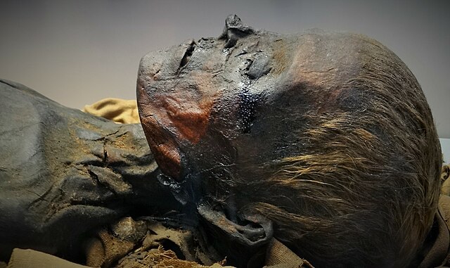
While Egyptian kings and queens are the most famous examples of mummification, the practice wasn’t just for pharaohs. It expanded over time until everyone from the poor up were being preserved for eternity.
So, where are all the mummies? Well, unfortunately, 700 years of rich Europeans ate them. For their health, of course.
From a 12th-century translation error, a massive trade kicked off, depopulating the tombs of Egypt to populate European apothecaries -– and starting an underground market in fake mummy powder.
Bitumen and mūmiyah
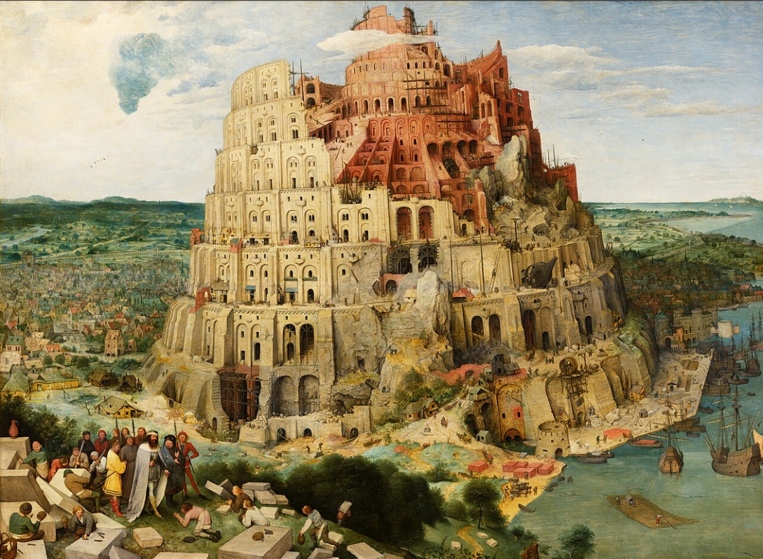
Why did Europeans think that eating mummies was a good idea? It's all to do with bitumen. Bitumen is a viscous petroleum product, which occurs naturally in a semi-solid form. Bitumen is particularly common around the Dead Sea, and is useful for waterproofing and as a glue. Archaeological evidence shows that both early humans and their Neanderthal cousins used bitumen tens of thousands of years ago. It even appears in the Bible as the mortar which was used in the tower of Babel.
By the classical era, bitumen was used in everything from shipbuilding to jewelry. People also started using it as medicine. Pliny the Elder, a Roman author and naturalist, lists 27 discrete medicinal applications for it. These include staunching blood flow, diagnosing epilepsy, treating leprosy, dysentery, and gout, and curing toothache.
After the fall of the Roman Empire, Muslim scholars took pains to preserve classical learning. By the Middle Ages, Arabic authors were considered the foremost medicinal experts throughout Europe and the Middle East. The tradition of using bitumen as medicine continued through the works of scholars like Avicenna, who prescribed it for concussions, paralysis, and more. He didn't call it "bitumen," though. He called it mūmiyah, from the Persian word mum, meaning wax.
A medieval game of telephone
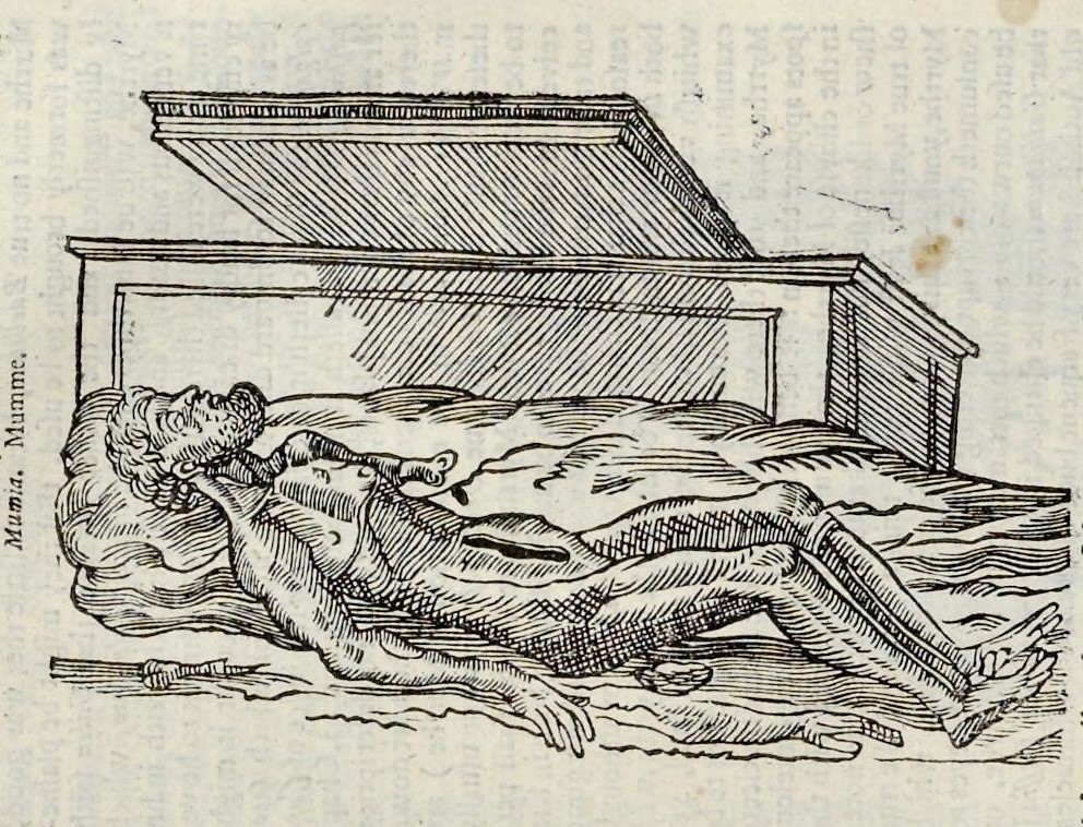
The Ancient Egyptians didn't use bitumen for their mummies. However, the dark resin they used resembled bitumen, leading many classical and medieval observers to believe that bitumen coated Egyptian mummies. So the same word came to refer both to naturally occurring bitumen and the dark waxy coating found on Egyptian mummies.
In the 12th century, an Italian translator of Arabic texts named Gerard of Cremona came across Rhazes of Baghdad's reference to mūmiyah. Gerard said the product was created when "the liquid of the dead, mixed with the aloes, is transformed and is similar to marine pitch.”
Another European, Simon Geneunsis, translated a work by Arab physician Serapion the Younger that referenced medicinal bitumen as "mumia." Geneunsis interprets the word along the same lines as Gerard of Cremona, calling it "the mumia of the sepulchers," which is formed when the aloes and spices used to prepare the dead mix with the liquids the corpse itself expels."
Meanwhile, crusaders were bringing back the bitumen medicine fad from the Islamic medical traditions of the Middle East. Unfortunately, the easily accessible supplies of bitumen in the area were limited. Shrewd Alexandrian merchants realized that there was all this mumia lying around, coating the bodies of the dead. They began raiding tombs, breaking the resinous bodies up, and exporting them to Europe.
The fact that the mumia came from corpses didn't bother people much, possibly due to the confusion between medical mumia and Egyptian mummies. Before long, mumia stopped being the substance on the mummy and became the mummy itself.
It's good for what ails you
Mumia became a wildly popular remedy in Europe, sold in every well-stocked apothecary. One influential pharmacopeia, Theatrum Botanicum, contains a long list of conditions mumia is useful for, including headaches, colds, coughs, seizures, heart problems, poisoning, scorpion stings, snake bites, bladder ulcers, paralysis, and retention of urine. Treatments involved combining mumia with other ingredients, usually a liquid like wine or goat milk.
Genoese physician Giovanni da Vigo considered mumia an essential medicine for ship's physicians and village doctors. He claimed it promoted wound healing and staunched bleeding. Sir Francis Bacon, the eminent English philosopher, and the physicist Robert Boyle, both considered it useful for wounds, falls, and bruises.
The French king, Francis I, was a habitual mummy consumer; contemporaries reported that he always carried a mixture of rhubarb and mumia on his person, just in case. Nicasius Le Febre, chemist to England's King Charles II, recommended mummy from Libya specifically.
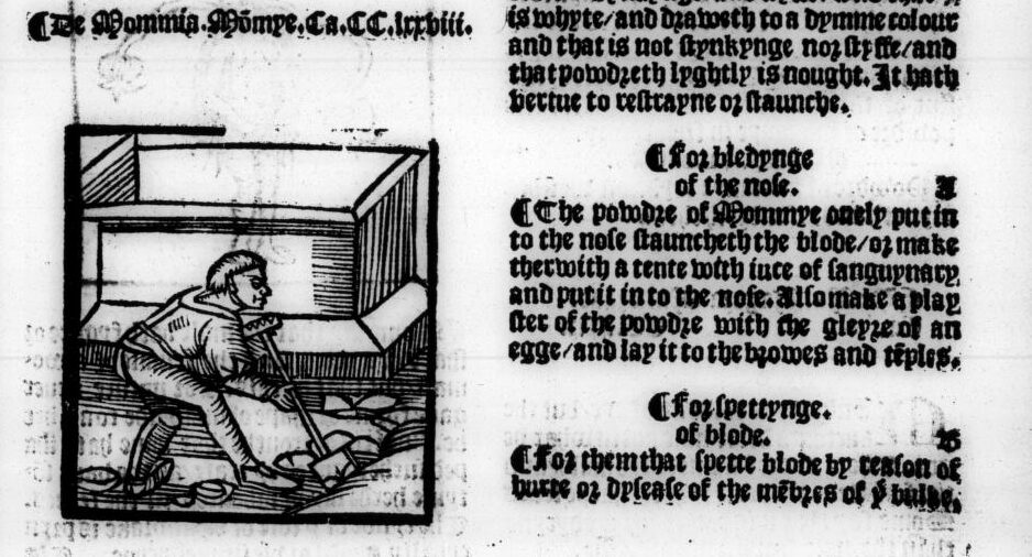
By the way, if you were wondering how it tasted, the English College of Physicians has the answer. Mummy was listed in their official pharmacopeia from 1618 to 1747, where it is described as being "somewhat acrid and bitterish."
Supply chain issues
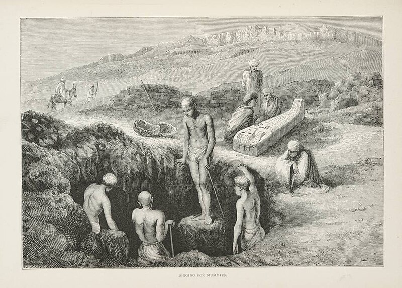
Egyptian authorities were not actually keen on all the grave robbing and corpse exporting that was happening. In 1428, authorities in Cairo captured and tortured several people connected to a mummy scheme. They confessed to robbing tombs, boiling the mummified bodies in a pot, and selling the oil which rose to the surface.
It was illegal to export Egyptian mummies out of Egypt. But enforcement could be lax, especially if you had money to grease the wheels. Englishman John Sanderson visited Egypt in 1586, where he explored a sepulcher and broke off chunks of blackened mummified flesh. He applied the correct bribes and compliments, and sailed off with 600 pounds worth of "divers heads, hands, arms, and feete."
For every literal boatload of real pillaged mummies, there was at least an equal measure of mummies created specifically for export. Many mummy sellers in Egypt found it was easier to source fresh corpses and dry them than it was to dig up old ones. These fresh corpses mostly came from executed criminals, plague victims, and enslaved people.
The Italian traveler Ludovico di Varthema wrote about the local production of mumia during a visit to the Arabian Peninsula. According to him, there were two kinds; the first was made from the dried-up remains of people who had died recently while crossing the desert. The other, nobler and more pure kind, was "the dryed and embalmed bodies of kynges and princes."
In truth, even authentic mumia wasn't made from rulers, but from their subjects. European nobles liked to imagine their healthful powder came from ancient priestesses and kings, but the remains of the poor were far more plentiful and accessible.
Paracelsus and domestic mummy manufacture
Though a fair amount of the mummy product on the market was inauthentic, the real stuff was still being sold into the modern era. One recent study analyzed the contents of an 18th-century pharmaceutical jar labelled "mumia." They found that the contents really were the remains of an Egyptian mummy from the Ptolemaic period.
But without our modern analysis tools, the question of mumia authenticity was an ongoing problem for physicians. As the supply became more questionable, some medical authorities began to wonder whether mumia being "authentically Egyptian" was even important.
Some definitions of mumia dropped the ancient Egyptian element entirely, ascribing benefits to any old preserved human flesh. The influential physician Paracelsus, who spawned a legion of followers, believed the medicinal benefit of mumia came from a transfer of life energy. To make his mumia, he left a fresh body out exposed. The best bodies were of young, healthy men who died suddenly. Other recipes in this line were even more specific, preferring a 24-year-old redheaded man who was recently executed.
There was a persistent belief that there was a vital animating force remaining in corpses, and one could benefit from this force by consuming corpse products. In the time of Paracelsus, for instance, executioners would collect and sell the blood of those they executed. People believed that drinking it promoted general health and cured epilepsy. Bandages soaked in human fat were applied to wounds, and powdered human skull was prescribed for headaches.
The broader genre of corpse medicine is beyond the scope of this article, but suffice it to say that mumia wasn't always the only human-derived medicine available.
Some reasonable concerns
Now I'm not a doctor, but I feel confident in saying that "you should eat powdered human corpses for nosebleeds" is not best practice. By the 16th century, many doctors were starting to think along the same lines.
Ambroise Pare, surgeon to four French kings, published a 1582 treatise decrying the use of mummy. He argued that most mummy sold was actually manufactured in France from the recently dead, and also didn't work. In his professional experience, it had not only failed to stop bleeding but had unsurprisingly caused the patient to have an upset stomach and bad breath.
Pare's German contemporary, Leonhart Fuchs, made similar arguments. He also laid out the series of medieval translation errors which had led to the idea of mumia. Fuchs decried the "stupid...credulity of certain doctors of our age," who still prescribed mummy.
Additionally, some commentators were beginning to recognize the historical and cultural wealth that was being ground up for tinctures. English natural philosopher Thomas Browne opined that "The Ægyptian Mummies, which Cambyses or time hath spared, avarice now consumeth. Mummy is become merchandise, Mizraim cures wounds, and Pharaoh is sold for balsams."
There was also cannibalism. Michel de Montaigne, a 16th-century French writer and early critic of colonialism, pointed out the hypocrisy of demonizing cannibalistic practices in the New World while taking medicinal human flesh at home. But most people didn't think of it as cannibalism, any more than people today would consider a blood transfusion cannibalism. Mumia wasn't food, it was medicine.
Still, as time went on, people were increasingly wondering if it was medicine they should be taking. Mumia mania peaked in the 18th century, but took much longer to fade entirely.

Consuming Egypt
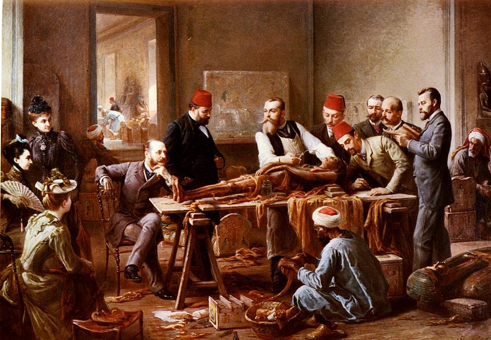
For wealthy Europeans, part of the appeal of mumia was the mystical, exotic associations. For centuries, Europeans treated the bodies of deceased Egyptians with a combination of fetishistic fascination and blatant disrespect. They were curios and collectors' items, souvenirs of exciting trips turned household decor.
Mummy unwrapping parties were popular in 19th-century Europe, where middle and upper-class men and women would watch a mummy's bandages be unwound, revealing its body as the finale of the morbid show.
The remains were consumable as a variety of commercial products. A popular paint color from the mid-18th to 19th centuries was "mummy brown." This pigment was made from ground-up mummified bodies. Art historians believe this rich, warm brown pigment appears in a number of well-known paintings, including Eugene Delacroix's famous Liberty Leading the People. The last tube of mummy brown was produced, unbelievably, in 1964.
There are also accounts, of varying reliability, that both human and animal mummies were used as fertilizer, paper (from their bandages), and fuel for locomotives. These claims are likely exaggerated, but they speak to the manner in which mummified Egyptian remains were treated at the time. As Imperial plunder, they were, literally, things to be consumed.
The end of the mummy-eating era?
By the end of the Victorian period, mumia had fallen out of popular use. But it was still available for sale, and occasionally prescribed, into the beginning of the 20th century. The last known appearance of the drug for sale is in a 1908 Merck catalogue. The German pharmaceutical advertised, "Genuine Egyptian mummy as long as the supply lasts, 17 marks 50 per kilogram."
Rich old Europeans didn't actually eat up all the mummies. Archaeologists are still finding them, for one. It's impossible to say how significantly the manufacture of mumia impacted the number of surviving mummified remains. It's safe to say, though, that nearly a millennium of looting Egypt led to the loss of untold historical and cultural knowledge.
The 1908 example is troublingly recent, but we might still be tempted to dismiss mumia as something from another, less enlightened age. Exporting ground-up mummy to eat as a health supplement is something so patently absurd that a modern reader might make the mistake of smugly holding themselves above all those involved in the practice.
It's true that we don't eat mummies anymore. But physical and cultural wealth is still extracted from exploited nations for the consumption of the global north.
Most human bones available for sale in the West, as curios or medical teaching tools, come from India, though the export of human skeletons was officially banned in the 1980s. World-class museums still display cultural artifacts and remains of colonized people for the predominantly white public to gawk at. Mummy remains merchandise.
"Herds and flocks lie on verdant pastures
Wealth and splendor..."
More than a thousand years after it was last heard, a long-lost hymn to the ancient city of Babylon has been brought back to life, thanks to AI. This remarkable rediscovery gives us new insights into this ancient city.
The hymn came from a collection of thousands of fragmented cuneiform tablets stored in the Sippar library in Iraq. The former city of Sippar lies about 70km from Babylon.
The breakthrough came when Professor Enrique Jimenez of Ludwig Maximilian University of Munich teamed up with researchers from the Electronic Babylonian Literature project. This aims to digitize text fragments from cuneiform tablets worldwide.
By the rivers of Babylon
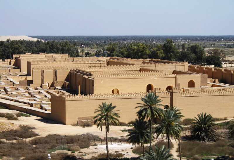
In recent years, they have started using AI to analyze the ancient fragments and recognize patterns in the cuneiform writings. What emerged was a 1,000-year-old hymn devoted to the Mesopotamian city of Babylon. Babylon was founded around 2000 BCE and was once the largest city in the world.
“Using [AI], we managed to identify 30 other manuscripts that belong to the rediscovered hymn -– a process that would formerly have taken decades,” Jimenez said in a statement.
Legend tells us that Noah hid the city's library of cuneiform clay tablets in Sippar before the biblical flood. The newly rediscovered hymn praises the city and gives an insight into the daily lives of the people who lived there.
“The hymn was copied by children at school," said Jimenez. "It’s unusual that such a popular text in its day was unknown to us before now.”
Role of women
Another striking aspect of the 250-line hymn is the numerous references to the roles of women and priestesses and the tasks they performed in the city. No other cuneiform tablets have these references.
“This is the first time we have found such explicit details about the lives of Babylonian women, especially in priestly roles,” he said.
Mesopotamian writings typically focus on wars, royalty, and the gods of the ancient world. While the hymn does mention deities, it also highlights the beauty of the natural world and the farming lives of common people.
“It was written by a Babylonian who wanted to praise his city,” explained Jimenez. "The author describes the buildings in the city, but also how the waters of the Euphrates bring the spring and green the fields. This is all the more spectacular since surviving Mesopotamian literature is sparing in its descriptions of natural phenomena.
Researchers have shared a short translated excerpt of the hymn that describes the Euphrates River and its importance to the city on its river banks.
The Euphrates is her river — established by wise lord Nudimmud —
It quenches the lea [open land], saturates the canebrake,
Disgorges its waters into lagoon and sea,
Its fields burgeon with herbs and flowers,
Its meadows, in brilliant bloom, sprout barley,
From which, gathered, sheaves are stacked,
Herds and flocks lie on verdant pastures,
Wealth and splendor — what befit mankind —
About 30,000 years ago, humans arrived in Japan's southern Ryukyu Islands, 110km from Taiwan.
The archaeological record hasn't preserved any clues as to how these Paleolithic people made the crossing to this new land. But the obstacles to doing so seem, at first glance, insurmountable without modern technology and knowledge. So in 2013, a group of Japanese archaeologists set out to recreate the trip using only Paleolithic tools.
This week, they published the results of their experiments in the journal Science.
A challenging crossing
Archaeologists find evidence of humans in the Japanese archipelago as early as 35,000 BCE. Judging from the dates at different archaeological sites, the earliest inhabitants of Japan seem to have migrated both northward from Taiwan and southward from Korea.
But from the Taiwanese coast, the low-lying islands of Ryukyu sit below the horizon. One of the strongest currents in the world, called Kuroshio ("Black Tide"), runs northward from Taiwan. It carries any lackadaisical drifters west of the Ryukyu Islands at a velocity of one meter per second. And a distance of 110km from Taiwan to the nearest Ryukyu island, Yonaguni, was no joke for people without metalworking or sails.
Yet they made it.
When the Japanese archaeologists set out to recreate this trip, they didn't have an easy time. They tried reed-bundle rafts and bamboo rafts, both of which floundered in the strong current. The bamboo also began to crack and fill with seawater, further weighing it down.

The beginning of the voyage
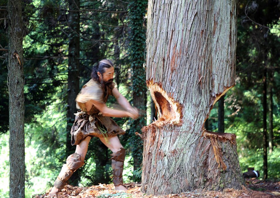
In July of 2019, the team attempted one final trip. They launched Sugime, a hand-made dugout canoe, from the coast of Taiwan in typical calm summer weather.
Construction of the dugout started in 2017. The team used replicas of stone axes found in Japanese Paleolithic sites to fell a one-meter-thick Japanese cedar tree. They peeled off the bark and carved a seating area in the center of the trunk. While dugout canoes from the Paleolithic haven't survived in Japanese archaeological sites, dugouts from the later Jōmon period (starting around 14,000 BCE) boast burn marks on the inside. In turn, the team polished the inside of their craft with fire.
The plan was simple: to row from Wushibi, on the eastern coast of Taiwan, across the strait to the small Ryukyu island of Yonaguni. A motorized ship with safety supplies would escort the Paleolithic reenactors.
Sugime's crew consisted of five paddlers, four men and one woman. For the first hour and a half of their journey, they skidded over a calm sea, with only wispy clouds on the horizon. Then the water depth dropped, and they hit the edge of the Kuroshio. The wind slammed into the current, giving rise to choppy water and an ever-present swell as high as the side of their boat. One of the crew had to pause paddling to bail out the dugout over and over again.
They kept rowing into the night. The wind dropped slightly, but the dugout kept threatening to capsize in the strong swell. There was no rest that night, and it was a constant fight to keep the nose of the dugout pointing northeastward. As the water approached a flow of 1 m/s, the dugout pivoted northward along with the current.

Just as steering the boat was a challenge, so too was figuring out where to steer it. Clouds obscured the stars, and GPS wasn't an option in the Paleolithic. Only the direction of the swell indicated which way was north.
As midnight approached, the wind dropped and stars appeared. The paddlers took turns resting. But in the early hours of the morning, clouds once again obstructed the stars. At 3:40 am, while the captain was taking his rest, one crew member thought she saw dawn on the horizon. The crew pointed the dugout accordingly.
Then the captain woke up. The dugout was traveling due north, dragging them off course from their destination. He realized that far from being dawn, the light on the horizon was from the northern cities of Japan and was reflecting off the clouds. Sugime turned eastward once more.
Exhaustion and triumph
The next day dawned bright. Still unable to see their destination, Yonaguni Island, the crew kept paddling east-southeast to combat the current of the Kuroshio. Unbeknownst to them, however, they had left the Kuroshio behind them. They were now heading due east, away from Yonaguni.
They had already exhausted all the water they had packed for the voyage. Tired and thirsty, they called in a resupply. At noon, finding themselves in calmer waters and realizing they had left the Kuroshio, the whole crew slept for half an hour.
As they paddled into the afternoon, Yonaguni still failed to appear. They steered the dugout this way and that, hoping it would peek above the horizon. It didn't. Moreover, the crew was exhausted. Some of them jumped into the ocean to rest in the cool water. But nothing prevented the onset of excruciating muscle cramps and, as evening drew close, hallucinations.

Then, just before the sun set, a bird flew overhead. Before this, the sea had been lifeless and isolated. Now, land was near, even if they couldn't see it.
The sun was so intense that the food they had brought with them began to rot. They obtained replacements from the escort ship and ate a dinner of rice balls and noodles. As night slid in, the crew rested while the boat drifted loose on the water.
The captain kept watch. He thought he saw the glint of a lighthouse on the horizon that he hoped was from Yonaguni. As it turned out, it was an optical illusion, but the swell carried the dugout gently northeastward. In the early hours of the morning, the actual light from Yonaguni's lighthouse appeared on the horizon.
When the crew awoke in the dark hours before dawn, they began the final stretch of their journey toward it.
It was not until just after dawn on the third day that the crew finally saw Yonaguni Island. They were 20km from shore and had been rowing for over 40 hours.
Five hours later, they reached land. Since their crew included Taiwanese paddlers, they had to follow immigration protocol and land Sugime at a predetermined beach. Paleolithic explorers, presumably, did not have this restriction.

Piecing together a Paleolithic voyage
The crew had made it. Dugout canoes, unlike reed and bamboo rafts, can cross the Kuroshio. But at various points during the trip, the crew's mistakes had worked in their favor. When they rested, the swell naturally carried them in the right direction. And the first hint they saw of Yonaguni was from a lighthouse, which does not feature in Stone Age archaeological sites. Was their success a fluke?
To test this, the team used the data from their paddling to simulate hundreds of dugout voyages starting from different points in Taiwan. They used both modern and Paleolithic oceanographic models to approximate the flow of the Kuroshio, varying the strength of the current between ebbs and peaks. As long as the virtual boats paddled in the right direction, they made the crossing, even when the Kuroshio was at its strongest.
But the voyage could not be completed by accident. The Kuroshio does not carry mariners from Taiwan comfortably to the shores of Yonaguni. Paleolithic humans had to identify the direction and strength of the Kuroshio and plan their voyage accordingly.
They also had to know Yonaguni was there. From the coast of Taiwan, it is not visible. Only when one climbs the mountains in the north does the little speck of island appear over the horizon. The summit of the highest of these mountains sits at nearly 4,000m.
This research in experimental archaeology shows that inhabitants of Taiwan 30,000 years ago did not drift aimlessly towards the Ryukyu Islands. They climbed mountains, they built sturdy boats, and they knew how to chart a course against one of the strongest currents in the world.
Deep in the northern Ontario bush, there is a stone covered in strange markings. No one knew it existed until a tree fell over and exposed it. Carved into the slab of rock are a series of ancient runes that archaeologists have been trying to decipher for years.
The stone was found in 2018, and pictures of it were quickly sent to Ryan Primrose, the director of the Ontario Centre of Archaeological Education.
“It's certainly among the least expected finds that I think I've encountered during my career. It's absolutely fascinating," he told the Canadian Broadcasting Corporation.
Primrose was worried people would assume that the markings on the stone slab were created by Vikings, so he has been quietly working on the mystery for seven years.
"We didn't want to release information publicly until we had done as much as we could at the time to understand exactly what it was," he said.
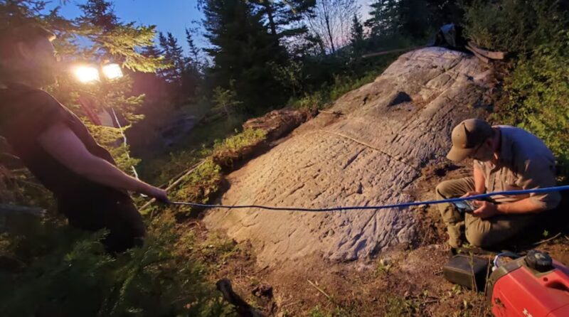
The stone slab, about the size of a small tabletop, is half-buried in the rocky ground. From a distance, it looks as though it is covered in scratches. It is actually a series of 255 runes alongside an illustration of a boat and 16 further runic symbols that have been purposefully carved into the rock.
Primrose decided to bring in runology expert Henrik Williams. He flew over from Sweden and sat under a tarpaulin for three hours with a flashlight, looking at the runes. He realized the symbols were Futhark alphabet runes, which were originally used in Scandinavia.
A confusing timeline
Etched into the bedrock is an early Swedish rune version of The Lord’s Prayer. The prayer can be traced back to 1611. This initially caused confusion. There were no Swedes in the region at that time, so who could possibly have carved this into the rock? But the prayer was republished in the 19th century, and at that time, the Hudson’s Bay Company did employ some Swedes. They had a trading post in Michipicoten, which is relatively close to the runes.
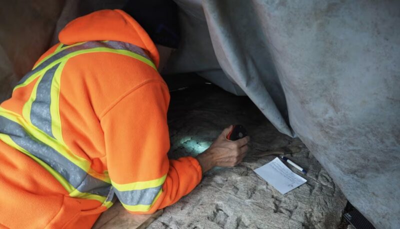
There is no way to know exactly how the carvings came to be, but Primrose and William reasonably think that someone working for the Hudson’s Bay Company is responsible. Etching all 255 runes into the rock is a task that would have taken days or weeks. Once created, they believe it might have been a central point for religious prayer or for Swedes to come together.
This timeline means that the stone is much newer than many would assume. Researchers estimate that it was carved around 1800. The team admitted they were a little disappointed to discover that the runes were not older.
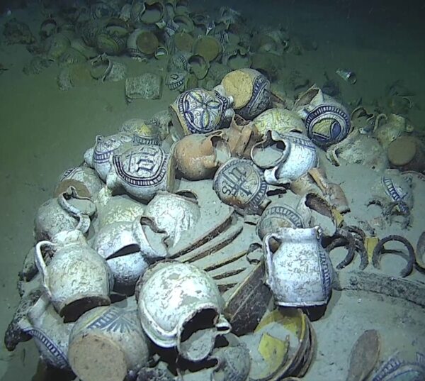
The deepest shipwreck ever found in French waters has been discovered in the Mediterranean off southern France. The 16th-century merchant ship lies an astounding 2,567m down.
The French Navy stumbled across the wreck in March 2025, south of Saint-Tropez, during a routine seabed mapping mission. When the drone's sonar picked up an unusually large structure, the curious operators sent down a remotely operated vehicle to investigate. What it captured was incredible -- the remains of a wooden ship that has laid untouched for centuries.
The wreck, now called Camarat 4, is a Renaissance merchant vessel, roughly 30 meters long by 7 meters wide. Experts believe it sailed from Italy, loaded with ceramics, cookware, and metal bars. Images show around 200 glazed ceramic jugs, 100 yellow plates, two cauldrons, and six cannons among the wreckage.
Many of the jugs bear the monogram “IHS” etched into them, the first letters of the Greek name for Jesus, or are adorned with geometric and plant-based patterns. The detailing on the jugs suggests they came from the Liguria region in Italy.
Frozen in time
Marine archaeologist Marine Sadania, who is part of the team leading the study, described the wreck as “frozen in time.” Its depth has kept it almost perfectly intact, preventing looting of any of the items. As a result, it offers an incredibly rare window into Renaissance maritime trade and shipbuilding.
This shipwreck now holds the record as France’s deepest ever discovered, surpassing the previous title holder, the submarine La Minerve, found in 2019 at 2,300m down.
Researchers plan to digitally map and study the wreck. Using high-resolution photography, they are building a complete 3D model of the site that will capture every detail, from the woodwork to the ceramic decorations. Robotic arms will recover a few select objects to gain a fuller picture of life aboard the ship; the rest will remain in place.
It seems that people 1,700 years ago enjoyed the same battles of endurance that you might find today in a country pub. Archaeologists have uncovered a marble sarcophagus from the Roman era in Caesarea, Israel. Haut-relief sculptures on the sarcophagus show a wine-drinking contest between Dionysus, the Greek god of wine, and the legendary Roman hero, Hercules.
A joint team from the Israel Antiquities Authority (IAA) and the Caesarea Development Corporation found the sarcophagus buried beneath a sand dune outside the city’s ancient walls. Excavation leaders Nohar Shahar and Shani Amit described the discovery as something out of a movie.
“We began brushing away the light sand of the dune when the tip of a marble object suddenly emerged,” they recalled. “The whole team gathered around, and as we cleared more sand, we could hardly believe what we were seeing.”
A defeated Hercules
A main panel shows a defeated Hercules clutching a cup and apparently unable to stay upright. Meanwhile, a victorious Dionysus celebrates with an entourage of mythological creatures and revelers.
Researchers believe the scene represents more than a mythological boys' contest, that it symbolizes the soul’s passage from the physical world to the afterlife.
“The figures are not only celebrating, they are accompanying the dead on their last journey, when drinking and dancing are transformed into a symbol of liberation and transition to life in the next world,” said Shahar.
Shahar also noted that this is the first time archaeologists have found the Dionysus-Hercules wine contest depicted on a burial coffin in the region. Similar scenes appeared in the 2nd and 3rd centuries, but they were typically found in mosaics, not sculpture.
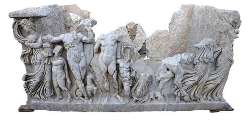
Although discovered in Israel, the artists likely used marble quarried from northwestern Turkey, since there were no local marble quarries in ancient Israel. Archaeologists think that the piece was created in Turkey, with some final details added after it arrived in Israel. The elaborate design and imported materials make it very clear that a wealthy family that “enjoyed a certain lifestyle" commissioned it "as a fitting reflection of their identity.”
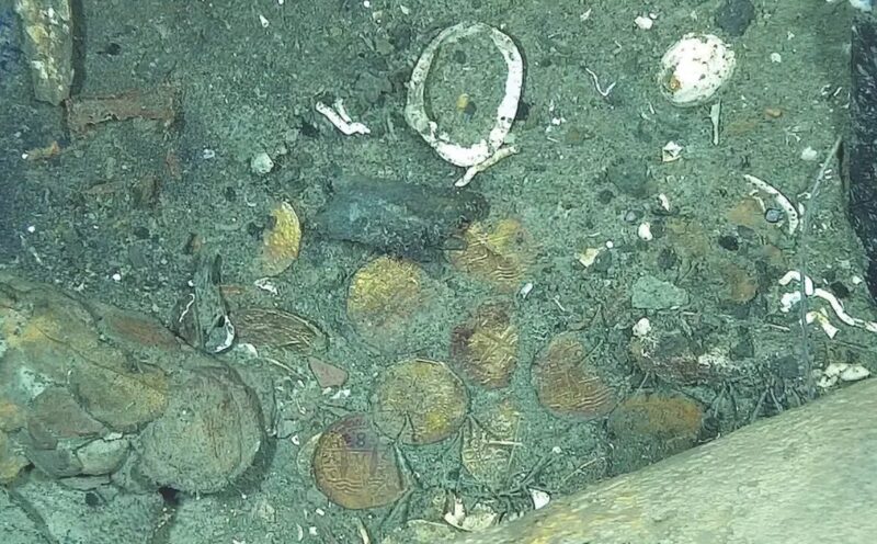
Researchers have finally confirmed that a long-sunken hulk off the coast of Colombia is none other than the San José. The legendary Spanish galleon, which vanished beneath the waves of the Caribbean 300 years ago, has been dubbed the “world’s richest shipwreck.” Now the big question is, who does the treasure belong to?
The San José was first launched in 1698 and was the flagship of the Spanish treasure fleet. In 1708, it was carrying gold and jewels from Peru to Spain that would help fund the War of Spanish Succession. As the ship approached Cartagena, Colombia, British naval forces attacked. During the melee, the gunpowder stores on the San José ignited, sinking the ship. Nearly 600 crew members perished as the ship went down with its vast cargo of gold, silver, emeralds, pearls, and other treasures.
For centuries, the wreck remained lost beneath the sea. Two groups claim they discovered the famous shipwreck. U.S. salvage company Glocca Morra (now Sea Search Armada) insists that it first found the location of the ship in 1981. Then, in 2015, the Colombian navy, working with marine archaeologists, located the actual remains of the galleon using underwater drones.
At a depth of around 600m, it is too deep for divers to access. This made it hard for researchers to confirm that it is definitely the San José. The Colombian navy has been using remotely operated vehicles to survey the wreck. The key to proving that it is the San José has been the gold coins scattered on the ocean floor.
Process of elimination
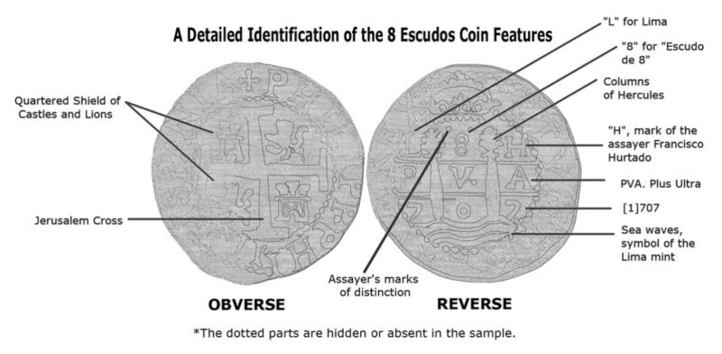
The lead author of a new study, Daniela Vargas Ariza, explained how these coins allow dating of the wreck and its demise through a process of elimination. These particular coins, known as "cobs," show mint marks from Lima, dated 1707. They also have castles, lions, Jerusalem crosses, and other Spanish imperial symbols imprinted on them.
“The finding of cobs...points to a vessel navigating the Tierra Firme route in the early 18th century," said the paper. "The San José galleon is the only ship that matches these characteristics.”
This Holy Grail of shipwrecks is now at the center of a legal battle. Colombia claims it is the sole owner of the wreck under its national heritage laws. They argue that as the ship lies within its territorial waters, it belongs to them. But others want to stake their claim over the ship and its $16 billion of treasure.
Spain contends that the San José is a Spanish ship and so it is Spanish state property. Sea Search Armada says it was the first to identify the general location of the wreck in the 1980s and so should receive some of the compensation. Indigenous communities from countries like Peru and Bolivia are also asserting claims to the treasure since most of it was pillaged from them when they were under Spanish colonial rule.
After hearings in Colombia and the U.S., the decision about who owns the most valuable shipwreck in the world will lie with the Permanent Court of Arbitration at the Hague.
Earlier this year, two amateur metal detectorists unearthed a pair of striking 1,400-year-old artifacts in Wiltshire, England. The gold-and-garnet raven's head and a gold ring with triangular garnet detailing date back to the Anglo-Saxon era.
Paul Gould and Chris Phillips made the discovery on January 8, during a metal detecting rally organized by the 9th Region Metal Detecting Group. Gould found the flattened gold and garnet ring. Shortly after, Phillips uncovered the intricately decorated raven's head. Experts believe the raven's head, which weighs 57 grams, was likely part of a larger object, possibly a drinking horn.
“This is the find of a lifetime…It's unbelievable — I'm a bit emotional," Phillips said in a YouTube video.
In early Europe, ravens were often associated with death. In German and Norse mythology, they were linked with Odin, the Norse god of war. Whether this artifact represented these themes is unclear. The use of garnet and gold was not uncommon during this era. It accurately reflects the level of craftsmanship and techniques from other notable finds, such as those of the Anglo-Saxon burial ship site at Sutton Hoo.
Following the correct procedure, Gould and Phillips properly reported the objects to the local finds liaison officer. Both items are now being cleaned and studied by experts at the British Museum.
Speaking to Live Science, Phillips said, "The finds will go through the treasure process now, which will take a while.” Anything with precious metals that is over 300 years old qualifies as a piece of treasure under the UK Treasure Act. The discovery of two objects so close together suggests the area may yield further treasures from the past.
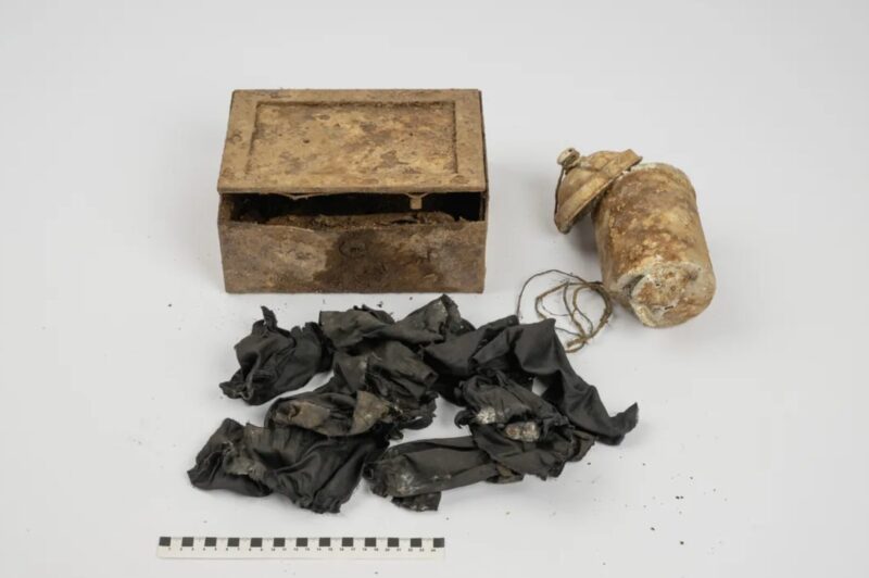
Two Czech hikers have unearthed nearly 600 gold coins in the Krkonose Foothills, near the Polish border. The pair stumbled across an old metal can sticking out of the ground and opened it to find a cache of coins that date back to 1808.
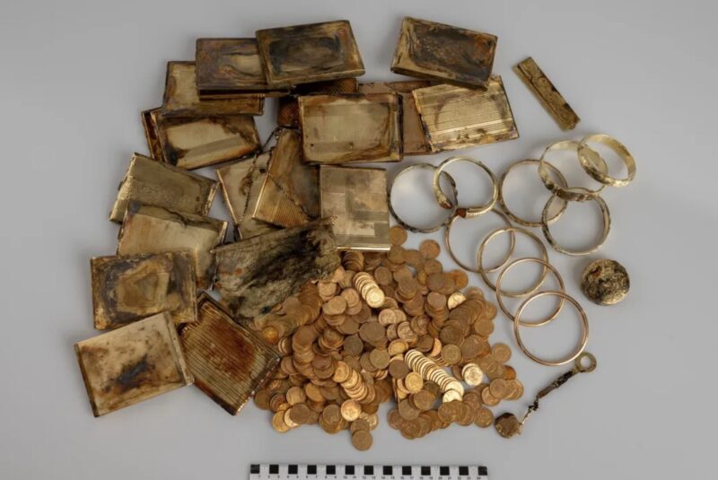
Beside the can, the hikers found a small iron box filled with cigarette cases, bracelets, combs, a key, and a powder compact. The pair took them to the Museum of East Bohemia. Its chief archaeologist, Miroslav Novak, told the Daily Mail, “I was called to say that a person who had found something was coming to see me. When he opened it, my jaw dropped.”
The 598 coins are all solid gold. Experts estimate that they and the rest of the items are worth an incredible $340,000. Novak added, “The historical value of the treasure, however, is incalculable.”
Mysterious backstory
The coins date from 1808 to 1915, with some extending into the 1920s and 1930s. They also originate from several countries, including France, Austria-Hungary, Belgium, Italy, Russia, and Turkey. All of the coins are stamped with dates, but some also contain a countermarking. This tells us that the coins were reissued in 1921, most likely in the region of modern-day Serbia and Bosnia and Herzegovina.
Why the hoard was originally buried is a mystery. One theory is that Czech or Jewish individuals concealed the valuables to protect them from the invading Nazis. Another is that fleeing Nazis might have hidden the hoard at the end of the war. The presence of coins from so many countries adds to the intrigue, suggesting a complex backstory.
“It was clearly not about the nominal value of the coins. It’s not about what the coins could buy — that’s not what mattered. It was deliberately hidden because it was precious metal,” explained Vojtech Bradle from the Museum of East Bohemia. After finishing their analysis and conserving the artifacts, the museum will display the collection to the public.
Under Czech law, individuals who discover treasure are entitled to 10% of its value. Given the estimated worth of approximately $340,000, the hikers will receive a substantial reward.
Animals that evolved in warm, tropical climes rarely decide to move to cold, snowy ones. Take any creature from the African grassland and drop it in Austria during an Ice Age, and the poor creature would surely not fare well.
Except Homo sapiens. We did just that, expanding into some of the coldest regions on Earth. New research into a 24,000-year-old site shows how technological innovations helped early humans keep warm during the Last Glacial Maximum.
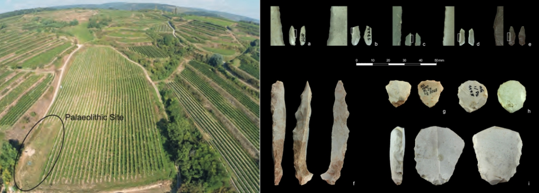
The early humans of Kammern-Grubgraben
While we tend to associate early humans with caves, Austria's Kammern-Grubgraben site is open air, with a highland on one side and a sloping river valley on another. Between 20 to 24 thousand years ago, humans frequently lived there.
Nearby sites had an even older human history -- 33,000 years. They were hunter-gatherers, who moved with the seasons, returning to the same camps year after year. Sophisticated tool users, they produced a wide range of stone tools, as well as jewelry.
The Kammern-Grubgraben site also contains a wealth of organic remains. Those remains belong almost entirely to one species: Rangifer tarandus, the caribou, or reindeer.
The people of Kammern-Grubgraben hunted caribou almost exclusively during the winter. Researchers knew the hunts had taken place in winter because the skulls still had their antlers, and reindeer shed their antlers after winter. Tooth wear also indicated winter or late autumn deaths.
Why were they only hunting caribou during the winter and autumn? Researchers believe that it was for their hides.
Sewing for survival
As the Thule people in the Arctic discovered much later, caribou hide makes clothing warm enough for almost any conditions. Their thick pelts of hollow, air-trapping hairs conserve heat like nothing else. Once the people of Kammern-Grubgraben acquired these hides, they used sophisticated sewing tools and techniques to create cold-resistant clothing. Sewing traditional fur clothing requires incredible patience and skill, but it can also be incredibly effective. Recreations of Stone-Age clothing handled even in harsh Northern winters.
In the same chronological layer as the caribou bones, archaeologists found eyed bone needles. Eyed needle technology allowed them to sew tight, fitted seams, making clothing much warmer and sturdier than simple draped pelts.
Around 24,000 years ago, the Last Glacial Maximum caused temperatures to plummet. In nearby sites that dated from before this Ice Age, archaeologists found a much broader range of animal remains, and no eyed needles. Here, the most commonly hunted animal was the mammoth, suggesting that hunters prioritized calories over clothing.
When their environment changed, the Stone Age people adopted new lifestyles and techniques to suit their new, chillier environment. This superior winter clothing allowed them to survive an increasingly harsh and unstable climate.
We imagine the ancient world as one made of stone. Marble temples, megalithic structures, and rock-hewn tombs dominate the modern image of the pre-modern period. That image is, of course, an inaccurate one. Stone is all that remains of sites whose flesh was largely made of wood and other fast-decaying plant materials.
This problem of materials is especially relevant to ancient seafaring. Up until the mid-19th century, ships were practically all wood. Worse, the bottom of the oceans tends to be a uniquely bad place to preserve things. Even vessels that sank fairly recently, such as the Titanic and HMS Erebus, are already decaying.
Because of the simple realities of rot, there are very few physical remains of classical-era ships. There is one place, however, where they can be found: the Black Sea.

The Hospitable/Inhospitable Sea
The Black Sea's unique ecological environment allows it to preserve ancient shipwrecks. Its 436,400 square kilometers fill the space between Asia and Europe, but its secret lies beneath that surface.
Ancient Greeks first called the Black Sea Pontus Axeinus -- the Inhospitable Sea. However, as the centuries went on and they established colonies along the coast, they called it Pontus Euxinus, which had the exact opposite meaning from the original name. They couldn't have known this, but these two contrasting names reflected the hidden duality of the Black Sea.
The top layer of the sea is oxygen-rich and therefore able to support complex marine life. Below 100-200m, however, all oxygen is gone. The Black Sea is the world's largest meromictic body of water -- a marine environment with two stratified layers that never mix.
The two layers exist because water only enters the sea near the surface, from rivers like the Danube and Kuban, and out through the shallow Bosphorus Strait. No water mixing happens below 150m.
Honestly, I was simplifying too much when I said there were only two layers. There are actually secret intermediate layers that keep the upper and bottom from mixing, but for our purposes (shipwrecks) there are two: oxygen-rich upper, anoxic bottom.
That bottom layer is actually most of the sea. Only 13% of the Black Sea is oxygenated. The anoxic layer is a pretty bad place to be alive, but a good place to be a shipwreck.
A hot spot for shipwrecks
The same currents and tides that wreck ships on the surface can also damage them once they've already sunk. Wrecks near rocky coasts are particularly vulnerable and are soon smashed to bits and dispersed.
In addition to those ocean forces, the shipwreck has many natural predators. Organisms like shipworms, gribble (a type of marine isopod), and other wood borers quickly attack exposed beams. Materials buried under sediment will be eaten by bacteria, which feed off sugars like the cellulose and hemicellulose in wood.
So the quiet, deep waters of the Black Sea anoxic zone present an ideal, shipworm-free environment. In 1976, Willard Bascom, an engineer and marine archaeologist, wrote about the possibility of Black Sea anoxic waters preserving a wealth of ancient wrecks.
The Black Sea is also well-situated for wrecking ships in the first place. People have lived along its coasts for tens of thousands of years. Over the centuries, its location between Europe and Asia, connected to the Mediterranean and several major rivers, made the Black Sea a locus of ancient travel and trade.
Its waters were a theater for maritime history, hosting Hittites, Thracians, ancient Greeks, Persians, Scythians, Romans, Byzantines, Huns, ancient Slavic groups, Goths, Vikings, medieval Italian traders, Ottomans, and more.
Technological limitations, however, long prevented investigation of its depths.
Testing the waters
In 2000, Robert Ballard led an expedition to the northeastern Turkic coast of the Black Sea. Ballard pioneered new deep-sea exploration techniques that led him to discover the wreck of the Titanic. Searching off the coast between the Bosphorus and Sinop, the team was also looking for Bronze Age coastal settlements.
The Black Sea Deluge hypothesis proposes that until about the 7th millennium BCE, the Black Sea was a smaller freshwater lake, and people lived on its banks. When the Bosphorus opened, the Mediterranean flowed in, transforming the lake into an inland sea. Finding evidence for this theory was a major goal of Ballard's expedition.
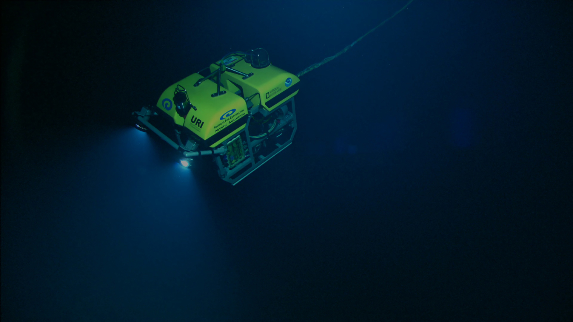
Using a combination of sonar and remotely operated vehicle (ROV) technology, the 2000 expedition surveyed the sea floor. Argus, a small imaging vehicle equipped with lights to illuminate the ocean floor, was dropped over the side and dragged behind a boat. The other vehicle was remotely operated and attached to Argus. Called the Little Hercules, researchers deployed it to recover objects or samples.
Under 100m of water, researchers traced what they believed to be an ancient shoreline, finding freshwater snail shells and a possible Neolithic settlement, which they named Site 82. Ballard and his team theorized that the regular limestone blocks were the remains of a manmade settlement.
Twenty-five years later, we still aren't completely sure how the water level in the Black Sea has changed over time. But it probably isn't as simple or dramatic as the Flood Theory posits. For half a million years, the Black Sea has been repeatedly isolated and connected as water levels fluctuated. But these are gradual processes -- there just isn't a lot of physical evidence for a catastrophic, sudden deluge.
But what about the shipwrecks?
Whether Site 82 is a neolithic settlement or just some squarish limestone, it was only one of several key finds. Up to about 85m of depth, years of bottom-net fishing have effectively destroyed the archaeological record. So they began at that depth, scanning a 50km stretch of coast between 85 and 150m.
In a fairly short time, they began getting hits. First, Shipwreck A: two clusters of ceramic vessels and a few half-buried planks, dated to the Late Roman era. Shipwreck B: more ceramic jars and submerged hull planks. The outline of this vessel is larger, and it appears to have a bilge pipe to pump water out of the ship. Based on this, researchers dated it to the Byzantine era. Shipwreck C was similar to Shipwreck A.
Shipwreck D
The promising findings offered new information on the location of an ancient trade route. But very little remained of the ships themselves; the water wasn't deep enough to preserve them. Off this coastal shelf, the sea bottom slopes abruptly downward to depths of 1,000m and more.
They turned to the trickier, deeper waters, with little initial success. With the expedition about to end, Ballard and his team made one final sweep -- and found something.
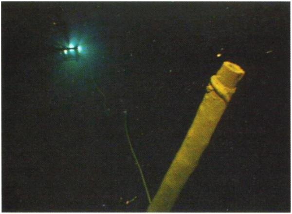
Shipwreck D sits upright in 320m of water. It's remarkably well preserved, with a deck structure, rudder, and mast rising 11m from the hull. There is even cordage wrapped around the top of the mast. Little Hercules collected a sample of the wood from the rudder area. The samples dated to 410-520 AD.
For such an old ship, it was shockingly well preserved, giving archaeologists insight into the construction of Byzantine ships. However, Shipwreck D, now called Sinop D, is most important as a sign of what else could be out there.
What else was out there?
Ballard and his team returned several times during the 2000s on further expeditions. They continued deploying Argus and Little Hercules to investigate sonar hits.
The technology continually improved, but was still a work in progress. Out of 500 hits, only 44 could be identified, and some of them turned out to be trash. The non-trash spanned a thousand years of history: An early medieval jar wreck, a 19th-century warship, three airplanes and even a WW2 Soviet destroyer, the Dzerzhynsky, named after the founder of the KGB.
Almost 10 years later, The Black Sea Maritime Archaeology Project used its ROVs in the Black Sea. A team from the University of Southampton set out on Stril Explorer, a state-of-the-art offshore survey vessel. They were there for the same ancient coastline debate Ballard investigated in 2000. It was almost by accident that acoustic and sonar data, combined with over 250,000 photographs, allowed them to find, map, and model 65 shipwreck sites.
Like the Ottoman ship above, most of them were trade vessels that sank in bad weather. They were far out to sea, along known routes. All were remarkably well preserved. One 13th or 14th-century Venetian vessel was the most complete of its type ever discovered. But the most impressive find was still yet to come.
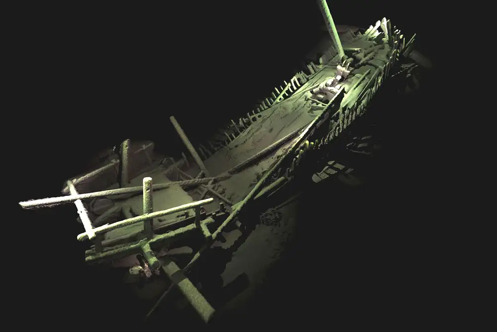
The world's oldest intact shipwreck
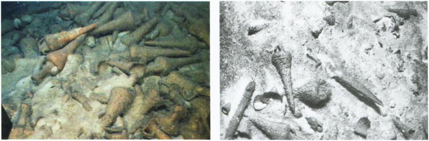
More than two kilometers under the surface of the Black Sea, off the coast of Bulgaria, lies a ship that is more than 2,400 years old. It was an Ancient Greek trading vessel, loaded up with goods meant for Greek colonies on the coast of the Black Sea.
The anoxic water has done its job; the 23m-long ship has an intact hull, with its precious cargo still hidden inside. The mast stands ready for winds that blew before the birth of Alexander the Great. There are intact benches for rowers who died before the invention of the number zero.
Because the cargo, which would usually be used to date the vessel, was inaccessible, the ROV took a small sample to carbon date. The result confirmed what the ship's design had suggested: It came from the 4th century BCE.
University of Southampton Archaeology Professor Jon Adams, who led the Black Sea MAP project, was stunned. An intact shipwreck of this age was unheard of. In fact, they could only recognize the ship's design from depictions on ancient pottery.
"This will change our understanding of shipbuilding and seafaring in the ancient world," Adams said in a press release.
This find is the world's oldest known intact shipwreck. Ships have sailed the Black Sea for over 2,400 years, though. Only a small fraction of its depths have been explored, and even older shipwrecks are still waiting to be found.
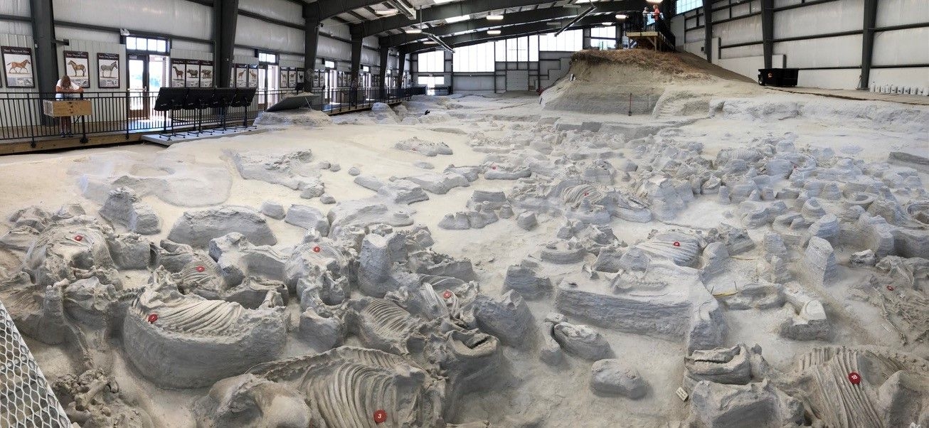
For over fifty years, a prehistoric rhinoceros mass grave has baffled paleontologists. Over one hundred rhino skeletons were found in the same spot, having all died together 12 million years ago. Now, a new study has revealed that this mass of animals, which died together, also lived together in one huge herd. How do we know? Their teeth.
Rhinos buried in ash
Located about 160 km from Sioux City, Iowa, the Ashfall Fossil Beds were created by the Yellowstone volcanic eruption 11.9 million years ago. When the volcano blew, a dense blanket of ash covered the entire region. Smaller animals died almost instantly, suffocating on the abrasive ash.
For larger, hardier creatures like the Teleoceras major, the barrel-bellied rhino, it was slower. Volcanic ash, on a microscopic level, is actually quite sharp, like tiny shards of glass. As it filled their lungs, animals slowly sickened and died. They came to the watering hole, seeking some relief in the cool water. There they died, and the wind swept more ash on top of them. What had killed them also preserved them perfectly.
In 1971, Michael and Jane Voorhies were walking down gullies in Northwestern Nebraska. Michael was a University of Nebraska State Museum paleontologist who hoped that erosion by nearby Verdigre Creek had revealed fossils.
It had. Emerging from the side of a gully was a flash of white bone, suspended in ash. Michael had found the skull of a baby rhinoceros. Excitingly, the skull was still connected to the neck, and the neck to the body.
Six years later, Dr. Voorhies came back with a crew from the University. The site is now part of a national park and is still an active dig site. The animals are suspended in layers showing their order of death: Small birds at the bottom, which succumbed first, then horses and camels, and rhinos last. There are over 20 species in total, and hundreds of skeletons, most of them rhinos.

Enamel revelations
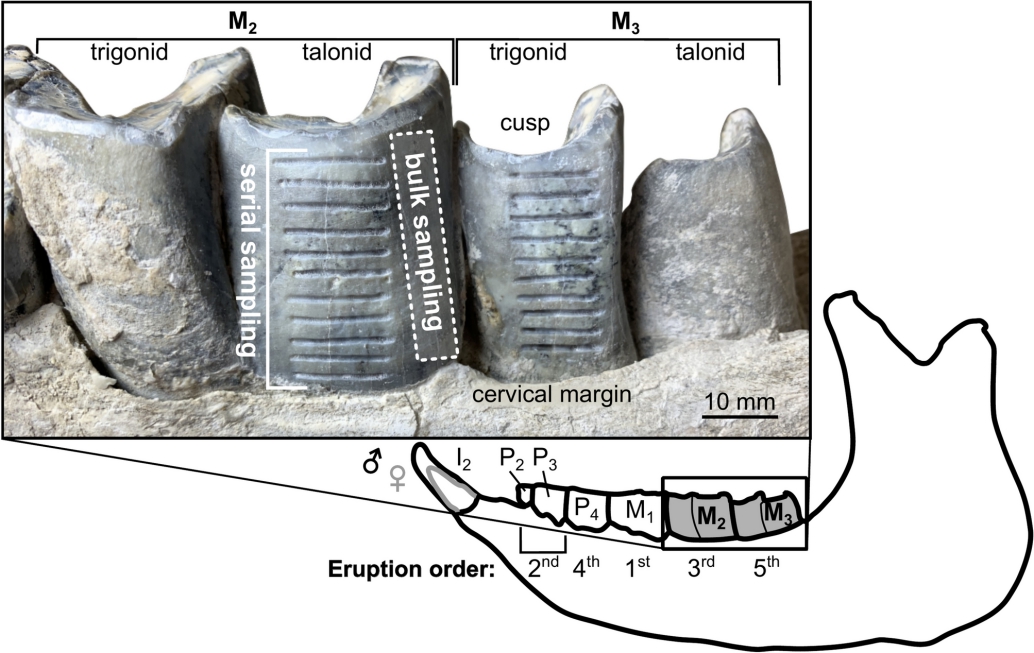
However, paleontologists weren't sure at first why the rhinos had all come together in such huge numbers. Were these separate individuals and small herds, all fleeing to the same hole? Or could they really be part of a single massive herd? Researchers at the University of Cincinnati set out to answer the question.
They took samples from the tooth enamel of more than a dozen individuals. Then they analyzed the isotope ratios present in the enamel. Atoms of the same element can have different numbers of neutrons, resulting in different "species" of a given element. Isotope analysis measures the relative amounts of these different species of element. Because different isotopes occur in different environments, and therefore different foods, isotope analysis tells scientists what (and therefore where) an animal was eating.
Using this analysis method, they were able to examine where and why the individuals were moving. Had they traveled a long distance to avoid destruction? Did they migrate seasonally, or leave for new territory upon reaching adulthood?
As it turns out, the answers to those questions are no, no, and no. All the individuals they sampled had been eating the same local food for their whole lives. Comparing their isotopic signatures to another local animal, a sabre-toothed deer, revealed a more aquatic diet. If T. Major was semi-aquatic, like modern rhinos, this would have restricted its movement, explaining the lack of migration.
The hundred-strong rhino group at Ashfall hadn't come together by chance, all fleeing the same disaster. They were one large herd, who had lived together and died together.
A stroll through prehistoric Nebraska
Before the eruption, Mesozoic Nebraska was a vast savannah, crisscrossed with streams and watering holes. Grazing animals fed on the open grasslands. The long-necked Aepycamelus, a giant extinct camel, grazed on the treetops, while small three-toed horses like Pseudhipparion gratum and Neohipparion affine munched on the grass beneath them.
The smaller grazing animals and the young of their larger cousins had a number of canine enemies to watch out for. The deadliest of them was Epicyon, the massive "bone-crushing dog" that weighed up to 170 kilograms.
Moving placidly along riparian corridors were great masses of barrel-shaped T. Major. Growing up to four meters long, they were low to the ground, built more like the modern hippopotamus. In massive herds of dozens of these fleshy, tusked tanks, they enjoyed their muddy wallows, unconcerned by the bone-crushing dogs.
The volcanic eruption was not the end of T. Major. The rhino species persisted for another seven million years, until climate change froze its wet, temperate grasslands.
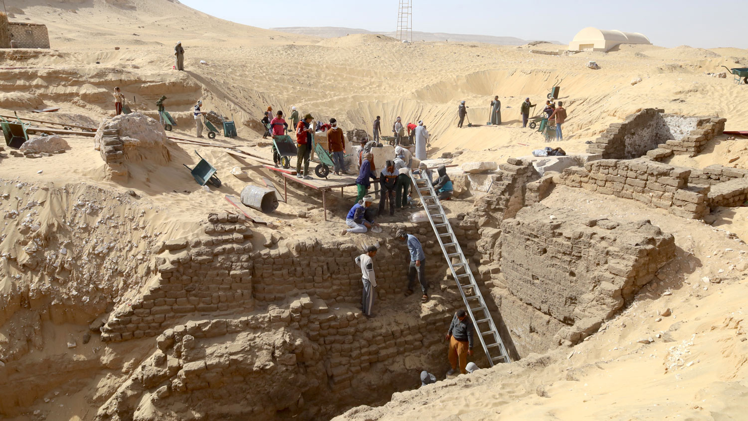
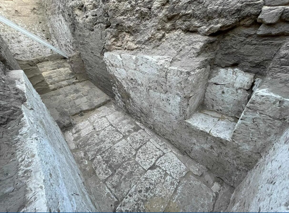
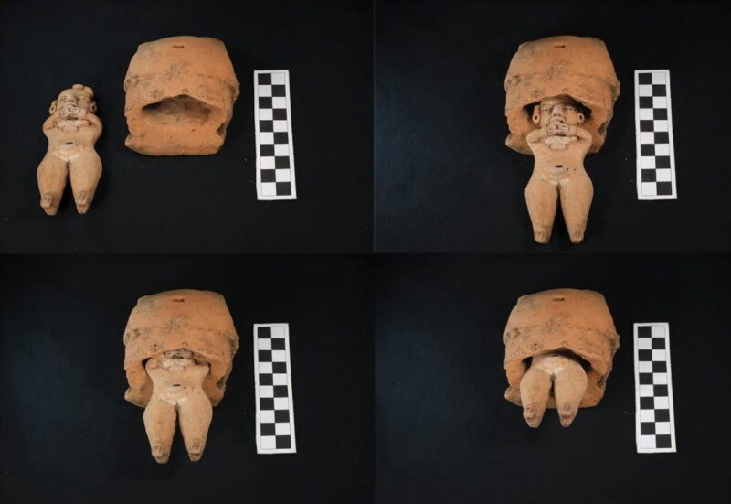
Archaeologists from the University of Pennsylvania were investigating Abydos, one of Egypt's most ancient cities, when they found a 3,600-year-old royal tomb.
From its location near the Mount Anubis necropolis and the surviving inscriptions, Egyptologists know the tomb belonged to a little-known royal family, the Abydos pharaohs. The discovery sheds light on a lost dynasty whose very existence scholars have debated.
Who were the Abydos pharaohs?
It's difficult to imagine how long the Ancient Egyptian civilization persisted. In England, there have been seven different ruling dynasties since the Middle Ages. Egypt had roughly 33 dynasties.
This makes it a little easier to understand how an entire ruling family could slip through the cracks of history. The existence of the Abydos dynasty was first proposed in the 1990s and only confirmed by the discovery of a tomb in 2014. This second tomb provides more evidence.
Egyptologists believe the Abydos pharaohs ruled from 1700 to 1550 BCE. This Second Intermediate Period marked the chaotic transition between the Middle and New Kingdoms, a time of famine, warring dynasties, and rapid regime change.
The last Middle Kingdom dynasty was when the Hyksos people swept into Egypt. They conquered the Nile Delta area known as Lower Egypt, becoming the 15th Dynasty.
Upper Egypt, meanwhile, was split in two. The 16th dynasty ruled Thebes and its surrounding area. The area around Abydos was ruled by, you guessed it, the Abydos Dynasty. The area was fairly small, and the Abydos reign short. They left few monuments behind.
Turin King List
The Turin King List, compiled by the famous 19th Dynasty King Ramesses II, only chronicles four Abydos rulers. The list detailed every pharaoh before Ramesses II.
However, the list was discovered in fragments, with some sections lost, so a degree of guesswork is involved. Pharaoh Senebkay, whose tomb was discovered in 2014, is not one of the four Abydos rulers on the Turin King List.
The new grave belonged to someone who was likely an ancestor of Senebkay, as they were buried in a similar style. Beyond that, Egyptologists can only guess.
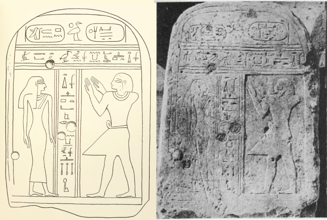
Looters stole the grave goods and the mummy and damaged the inscriptions. On either side of the tomb entrance, yellow bands once showed the pharaoh's name and images of the goddesses Isis and Nephthys. You can still make out the sister deities, but the name has vanished.
The Pennsylvania team, led by Josef Wegner, believes the tomb could belong to either Senaiib or Paentjeni. Both have monuments in the area, and researchers have not found either of their tombs.
More to find
The Abydos tomb is the second royal grave Egyptologists have unearthed this year. The first belonged to Thutmose II, husband of the famous female pharaoh Hatshepsut.
Wegner and his team will continue excavations near Mount Anubis. More Abydos dynasty and Middle Period kings may be in the necropolis, Wegner believes.
For the Ancient Egyptians, Abydos was the burial place of the god Osiris, ruler of the afterlife. This made it a sacred city and the burial site for many of the earliest pharaohs. The kings buried here are much older than Thutmose II or the famous Tutankhamun, and their lives are much more mysterious. The Mount Anubis excavations may unearth their long-buried history.
Lush greenery is as unexpected in the Sahara as it is in Antarctica. Yet both were once home to more temperate ecosystems. Unlike the jungles of Antarctica, which froze away many millions of years ago, the Green Sahara was recent enough to host early humans.
Every 21,000 years, the Sahara experiences a wet, rainy period, turning it into a woodland. The last North African Humid Period occurred between 14,500 and 5,000 years ago. During that time, an enigmatic group of pastoral people called the region home.
But who exactly were they? Where did they come from? What happened to them when their home became a desert again? All this has long been a matter of debate.
A new study in Nature reveals the results of DNA testing, suggesting a clearer origin for the Green Sahara people.
Deciphering an ancient genome
The Takarkori rock shelter is tucked against the Tadrart Acacus Mountains of southwest Libya. Humans lived here from 10,200 to 4,200 years ago. Archaeologists have unearthed a number of artifacts, the most important finds are the 15 sets of human remains in the back of the cave.
A team from the Max Planck Institute for Evolutionary Anthropology in Germany decided the most likely remains for testing were a pair of adult female mummies carbon-dated from 6,800 to 6,300 years ago. Carefully, researchers extracted genetic material from their naturally mummified remains.
Conditions in the Sahara degrade DNA, making research into population change extremely difficult. The DNA was too damaged to construct a complete genome, but researchers were able to compare specific sections of code to almost 800 individuals from modern Africa, the Near East, and Southern Europe.
The unique people of the Green Sahara
Genetic analysis revealed that the Takarkori people were part of a unique, somewhat isolated group. Their overall ancestry was North African, and significant migration in or out of their population had not occurred.
This runs counter to previous theories, which suggested northward migration from sub-Saharan Africa. Around the height of the last humid period, the Green Sahara people moved from hunter-gathering to a more sedentary herder's life. Previously, researchers believed that sub-Saharan people moving through the area had introduced domestication.
The Takarkori people. also had far less Neanderthal DNA than other North African populations. They were fairly isolated genetically, but with a moderate population of around 1,000 people, they weren't in a population bottleneck.
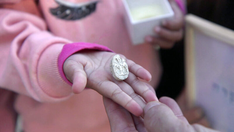
When kids are outside they pick up anything that catches their eye -- an oddly shaped rock, leaves, sticks, bugs. There are endless possibilities. But when three-year-old Ziv Nitzan was out walking with her family near Tel Azekah in central Israel, she picked up something far more unusual: a 3,800-year-old Egyptian artifact.
The small object she found is an ancient scarab amulet dating back to the Middle Bronze Age.
“Out of the 7,000 stones around her, she picked up one stone,” Omer Nitzan, Ziv's older sister, said in a statement. "Then she brushed off the sand and saw that something was different about it. I called my parents to come see the beautiful stone and we realized we’d discovered an archaeological find!"
Ancient scarab
Tel Azekah is a known archaeological site, and excavations have taken place there for around 15 years. Shaped like a beetle on one side and with engravings on the other, Nitzans' parents knew they might be looking at something old and valuable. They contacted the Israel Antiquities Authority (IAA).
The IAA confirmed the authenticity and significance of the Canaanite scarab. The Canaanites were an ancient Semitic people who lived across parts of modern-day Israel, Palestine, Lebanon, Syria, and Jordan.
“Scarabs were used in this period as seals and as amulets," explained Daphna Ben-Tor from the IAA. "They were found in graves, in public buildings, and in private homes. Sometimes they bear symbols and messages that reflect religious beliefs or status.”
Tel Azekah was an important city in the Judean Lowlands during the Middle and Late Bronze Ages. Archaeologists have discovered many Egyptian and Canaanite objects in the area.
“The scarab found by Ziv joins a long list of Egyptian and Canaanite finds discovered here, which attest to the close ties and cultural influences between Canaan and Egypt during that period,” commented Oded Lipschits, director of the Tel Aviv University excavations at the site.
How did it wind up on a hiking trail?
Lipschits also explained how the ancient artifact ended up on a hiking trail. In 1898, when excavations first took place at that site, British archaeologists found an acropolis, a citadel, and an array of artifacts. After their dig, the man who owned the land asked them to fill the area they had excavated so he could farm there.
“So the modern layers are now inside, and the old layers that used to be very deep in the ground are now on the surface, Lipschits told The New York Times. "This is why people can find all kinds of ancient items like these scarabs on the surface.”
Experts will now study the amulet further. Nitzan and her family received a certificate of appreciation from the Israel Antiquities Authority for their “good citizenship.”
In the dying years of the Roman Empire, a vassal king in the distant territory of Wales rallied his forces to shake off Roman rule. When the Saxons, too, turned their eye on his kingdom, that Welsh king joined with his northern confreres to beat them back. Eventually, he founded a model kingdom 800 years ahead of its time, complete with knights, metal armor, and even an early form of parliament.
His name was King Arthur, and unfortunately he did not exist, at least in a recognizable way. But the late medieval writers who crafted his legend would have had cause to rejoice this week. Digital archivists at the Cambridge University Library have just recovered a new fragment of their work, hidden in plain sight for centuries. It had been used as the binding for an Elizabeth property register.
How a 13th-century story became the cover of a 16th-century book
Stories of King Arthur were all the rage in the 1200s. After the self-described historian Geoffrey of Monmouth popularized Arthur's legend in the 11th century, the setting of the Round Table spread across the Channel. What had once lived in the realm of pseudo-historical tracts and Welsh oral tradition reached the courts of France.
The defining stories of early French Arthuriana were poems. Marie de France, one of the most famous female French authors in history, wrote short, often satirical verse set in Arthur's court. At the same time, the daughter of Eleonore of Aquitaine, Marie de Champagne, commissioned the first stories of Sir Lancelot and Queen Guinevere's forbidden love and of the Grail Quest.
These stories captured the imagination of the French and English nobility, culturally bound from the Norman conquest of England in 1066. In about 1200, an anonymous coalition of authors adapted them into what may be the first European fantasy blockbuster: the five-book series known as the Vulgate Cycle.
The Vulgate Cycle
Novels were a new concept in Europe. But the magical quests, epic sagas of family strife, and heart-rending character arcs of the Vulgate Cycle were so successful that they endure even today. If you've heard of the Lady of the Lake, of Lancelot and Guinevere's affair triggering the downfall of Camelot, of the Holy Grail being the cup that caught Christ's blood on the cross, then that's the Vulgate Cycle at work.
By the 16th century, though, stories of the Round Table were passé, especially in England. In the same way that a 21st-century scrapbooker might dismember an old novel, Elizabeth bookbinders yanked out a handful of pages from a copy of a Vulgate book. The copy they used dated to about 1300. They needed to bind a register of property deeds, and parchment was precious. So they folded up the Vulgate pages and sewed them into a new cover. There, the pages sat for half a millennium.
Recovering the story
In 2019, archivists at Cambridge University were sorting through the records of an estate in Suffolk when they realized that the cover of the property register contained fragments of a much older text. But it would be impossible to unfold the fragments without damaging the cover it comprised, an important historical artifact itself. More advanced methods would be needed to read the cover text, and in 2023, Cambridge began a new program to do so.
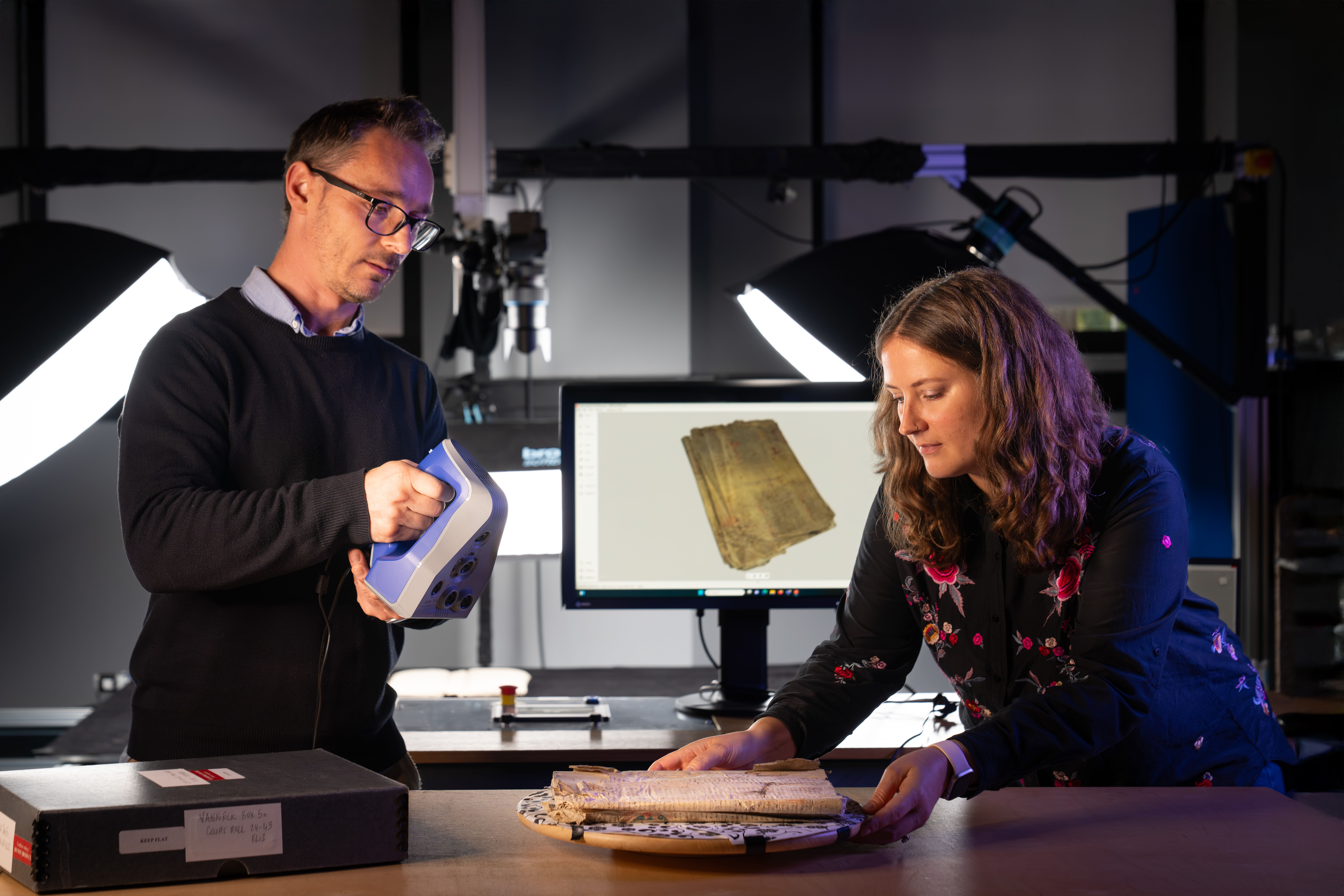
Just this week, the Cambridge Digital Library released the first results from this project. Archivists used multispectral imaging (MSI) to scan the whole text without unfolding the cover. MSI breaks images down into color categories, allowing conservationists to deblur old writing or even recover the traces of erased text.
CT scans probed through the folded layers of parchment. Finally, new techniques in digital image manipulation allowed the team to "unfold" the text and read it.
The wizard Merlin greeted them.
Merlin's magical shenanigans
Nowadays, images of Merlin are dominated by two pop culture phenomena. Either he's a spry old wizard in a blue hat who ages backward (as portrayed in TH White's The Once and Future King and its Disney adaptation, The Sword in the Stone), or he's Arthur's 20-something best friend, as in the BBC TV show Merlin.
The medieval Merlin was a lot stranger. He was born speaking like an adult, the child of a human woman and a demon. He could disguise himself however he wished and was prone to prophesying the downfall of those around him. (Personally, if my wizard advisor handed me a sword inscribed with the words, "With this sword, Sir Lancelot shall kill the man he loves most, and that man shall be Sir Gawain," I wouldn't let anyone named Lancelot or Gawain anywhere near my peaceful Round Table.)
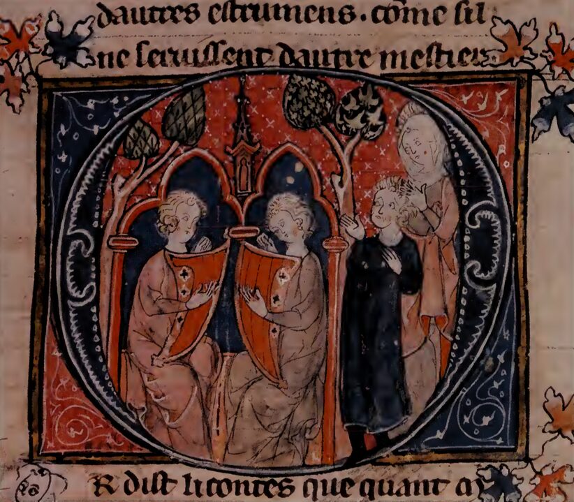
On one occasion, Merlin arrived at Camelot disguised as a blind harpist: "While they were rejoicing in the feast, and Kay the seneschal brought the first dish to King Arthur and Queen Guinevere, there arrived the most handsome man ever seen in Christian lands. He was wearing a silk tunic girded by a silk harness woven with gold and precious stones, which glittered with such brightness that it illuminated the whole room."
This is the excerpt that made up one of the two pages sewn into the cover. So far, the Cambridge Digital Library has only released the above passage, which agrees with other copies of the Vulgate Cycle. They are currently working to produce an annotated version of the whole text. Medieval scribes often edited or even rewrote the stories they copied, so it's possible this text could differ substantially from other manuscripts.
A medieval action hero

Although nowadays Arthur and Merlin are probably the most famous characters from the Arthurian canon, medieval readers had a favorite knight, and it wasn't Lancelot. It was Arthur's hot-headed, charismatic nephew Gawain.
Arthur has a relatively idyllic childhood in the Vulgate Cycle. A kindly knight raises him alongside his own son. But the children of his elder sister Morgause are less lucky. From a very young age, they fight alongside their father in wars against the Saxons. In addition to the Merlin episode, the property register cover text also includes a scene from this plot arc, in which Morgause's eldest son Gawain rides his beloved horse Gringolet into battle.
This is one of the final snapshots of Gawain as a teenager in the Vulgate Cycle. Soon after, one of Arthur's knights kills his father in battle. The young Gawain vows revenge, and although he later joins the Round Table, his vendetta against his father's killer spirals into a vicious blood feud that contributes to the fall of Camelot.
Of course, that's the version in other manuscripts. In the property register folio, none of that ever happens. Merlin dazzles Arthur's court, and Gawain rides victorious into battle. The rest is left to the reader.
When exactly did human language emerge? A new study suggests that humans have been chatting away for at least 135,000 years.
Researchers from MIT took a new approach to unravel that old mystery. Rather than look at fossils and artifacts, they studied the movement of ancient populations via 15 genetic studies conducted over the past 18 years. Three featured Y chromosome analysis (tracing paternal lineage), three examined mitochondrial DNA (tracing maternal lineage), and nine were whole-genome studies. All indicated that early Homo sapiens began diverging around 135,000 years ago.
The researchers believe it is likely that all languages stem from a single original one. This would mean that ancient humans had the capacity for language before we spread across the planet.
"All languages are related," explained lead author Shigeru Miyagawa. "The first major split among humans occurred around 135,000 years ago, so we can infer that language must have existed by then — or even earlier."
All languages linked
Previous 2017 research suggested a similar idea but was based on fewer studies. “Quantity-wise, we now have more studies, and quality-wise, we have a narrower time window,” Miyagawa said. A linguistic expert, he believes that all languages are linked. In the past, he has studied the similarities between English, Japanese, and some Bantu languages.
Some believe that language can be traced back millions of years based on the vocal abilities of other primates. But while primates can make sounds and communicate with each other, it is nothing like human language. For Miyagawa, the question is not when primates could make certain sounds but when ancient humans developed the cognitive ability to develop a language.
“Human language is different because there are two things –- words and syntax -- working together to create this very complex system," he explained. "No other animal has a parallel structure in their communication system. And that gives us the ability to generate very sophisticated thoughts and to communicate them to others.”
A second question is when we started using language socially and in our daily lives. Archaeological evidence suggests that widespread symbolic behavior emerged around 100,000 years ago. Artifacts such as engravings on stone walls show abstract thinking and the ability to convey a message or piece of information.
“Language was the trigger for modern human behavior,” Miyagawa says. “Somehow, it stimulated human thinking...If we are right, people were learning from each other [thanks to language] and encouraging innovations of the types we saw 100,000 years ago.”
DNA analysis has revealed that Stone Age people from North Africa descended partly from European hunter-gatherers. This shows that early people not only came out of Africa but, much later, some returned to it by boat across the Mediterranean.
Researchers analyzed the genomes of nine individuals from archaeological sites in present-day Tunisia and Algeria, all dating from 6,000 to over 10,000 years old. The remains showed genetic markers that linked them to Europeans.
One individual from Djebba, Tunisia, had approximately 6% of his DNA traced back to European forebears. The intermingling took place around 8,500 years ago. A woman from the same site showed similar European genetics.
It is difficult to determine exactly where European ancestry comes from. It could have come from Sicily or a small island called Pantelleria between Sicily and Africa.

Island hopping
It seems unlikely that prehistoric humans crossed the Mediterranean in a single journey. Instead, the new study suggests that they island-hopped across the Sicilian Strait. Proving this theory will, however, be difficult. Many of the islands that could have acted as natural stopping points are now completely submerged, alongside any archaeological evidence they might have held.
No boats from this period have ever been found in North Africa, but dugout canoes of that age have turned up in Bracciano Lake, Italy. This proves that ancient Mediterranean populations were capable of creating seafaring vessels that could have made the journey.
Archaeologists have unearthed five ceramic puppets from a pyramid in San Isidro, El Salvador. The figurines date back 2,400 years, and significantly, all have dramatic facial expressions.
The figures depict four women and one man, and their expressions change depending on the viewer's perspective. At eye level, they appear angry; from above, they seem to be grinning; and from below, they look scared. Researchers believe this enhanced the puppets' roles in rituals and storytelling.
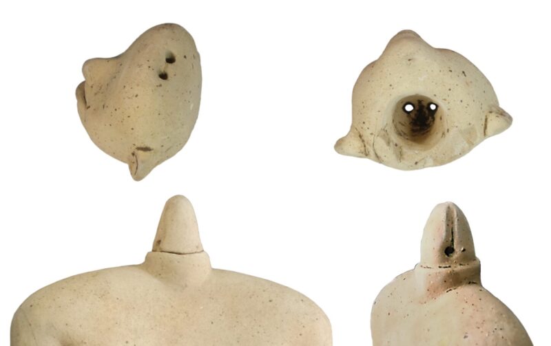
Each of the small statues has small holes drilled into it so that string can pass through, suggesting that they were operated like marionettes. Part of the smallest figure fits neatly inside the hollow torso of another and was possibly used to represent birth.
All five ceramic figurines lay near the top of the pyramid, less than half a meter below its apex. Three are about 30cm tall, while the other two measure 18cm and 10cm. The larger figures are unclothed and feature movable heads with open mouths, allowing dynamic expressions during performances.
“They are clay actors...When you hold them in your hand, sometimes they even look creepy because of their vivid expressions,” Jan Szymanski, co-author of the study, told Science magazine.
Researchers first discovered the puppets in 2022. At first, they thought the figurines were part of a burial offering, but the lack of human remains nearby suggested that instead, they served for public rituals or displays. Archaeologists have found similar figurines in Guatemala.
It seems that El Salvador was not as isolated as researchers have suspected until now. Similar items cropping up in various countries suggest a cultural interexchange or shared tradition among ancient Mesoamerican communities.
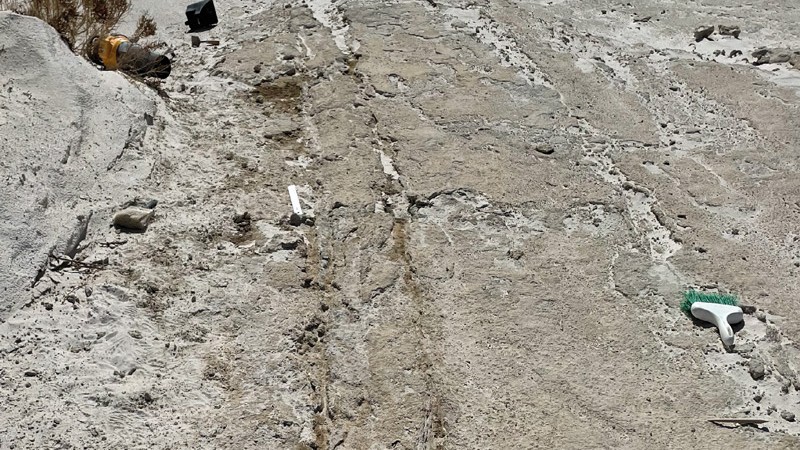
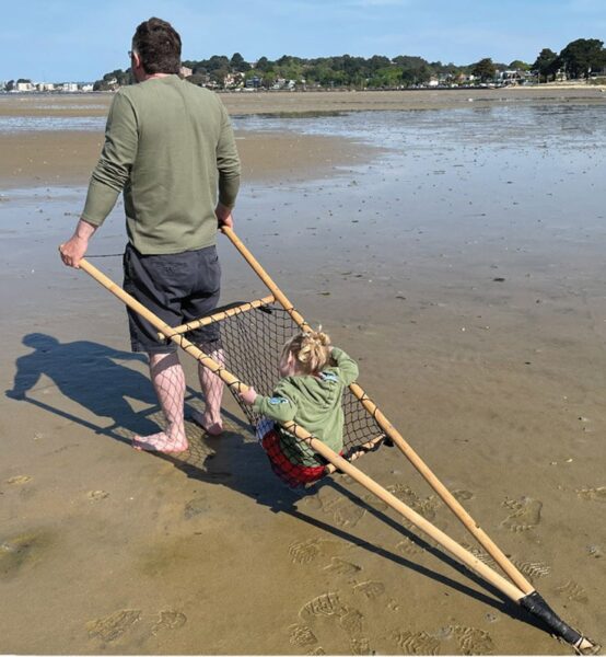
At White Sands National Park in New Mexico, archaeologists identified 20,000-year-old human footprints and parallel drag marks that they believe were left by a travois.
A travois is a simple wooden frame made from two intersecting poles bound together in an A or X shape. Heavy loads rest on the frame, which a person then drags behind them. This new finding is the earliest proof of human transportation technology in the Americas.
Indigenous people in the Great Plains regularly used travois to haul their goods and tents around. While dogs or horses pulled more modern travois, the ancient tracks at White Sands indicate a time when humans themselves dragged them from place to place. Modern indigenous people from the region agree with these conclusions.
A shopping cart minus the wheels
The presence of both adult and children's footprints beside the drag marks paints a vivid picture of prehistoric family life. Adults transported the belongings while kids walked nearby. Matthew Bennett, the lead author of the study, likened it to the modern use of shopping carts.
"Many people are familiar with pushing a shopping trolley around a supermarket...with children hanging on," he said. "This appears to be the ancient equivalent, but without wheels.”
We know that our earliest ancestors must have used some form of transportation to carry their possessions, but any wooden vehicles have long rotted away.
"These drag marks give us the first indication of how they moved heavy, bulky loads around before wheeled vehicles existed," says Bennett.
The team began excavating the site four years ago. In 2023, they dated footprints to somewhere between 21,000 and 23,000 years ago. If they are correct -- there remains some debate around the topic -- then humans arrived in North America a few thousand years earlier than we've believed.
The drag marks, some of which extended over 50 meters, were preserved in dried mud and buried under sediment. Some were single lines, others two parallel lines very close together. The team thinks this shows the two types of travois used by the ancient humans. The single lines show the tracks made by an A-shaped frame. The parallel lines show tracks made by an X-shaped frame.
To test their hypothesis, the research team constructed replica travois and dragged them across mudflats in Dorset, UK, and Maine in the U.S. The resulting marks closely mirrored the ancient tracks at White Sands.
Some sections of Great Wall of China in Shandong Province are 300 years older than previously believed, according to recent excavations. Those ancient sections date back to the late Zhou Dynasty (1046–771 BC).
Researchers believe that the joining of regional walls to create a single defensive structure against northern invasions occurred much later, in the Qin Dynasty, around the 3rd century BC.

“The layout, location, and infrastructure of the Great Wall of Qin reflect the advanced military planning and strategy of the Qin State to external threats,” project leader Zhang Su said in a statement.
Scholars previously thought that the oldest sections of the wall dated back to the 7th century BC. Recent excavations showed that was an underestimate.
Archaeologists used various techniques, including carbon dating, on a 1,000-square-meter section of the wall to discover that it was three centuries older than suspected. The study also revealed that there were distinct phases during its construction.
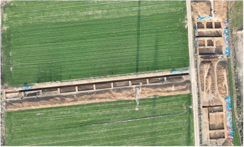
The oldest parts of the wall are about 10 meters thick and used rudimentary construction techniques. Though parts dated back to the early Spring and Autumn Period (770-476 BC) as expected, some of the foundations were much older -- as late as 1046 BC.
Sections built during the later Warring States Period (475 BC-221 BC) are almost three times as wide, spanning 30 meters at some points. These newer parts of the wall are also significantly more sophisticated.
Archaeologists also uncovered two residential structures beneath the early wall sections. These dwellings have square foundations with rounded corners -- typical of the Zhou Dynasty.
As research continues, we will learn more about the Great Wall's evolution from a series of regional fortifications to the 641km structure it became.
Eighteen thousand years ago, our Ice Age ancestors practiced both cave art and cannibalism. Human remains found deep in a Polish cave bear unmistakable signs of butchery. These people came from the same stock as those who created the famous cave paintings at Lascaux, France and elsewhere in Europe.
Archaeologists made the discovery in the Maszycka Cave in southern Poland, near modern-day Krakow. Over the last century, researchers have excavated the cave often and found human remains and bone tools. This new study focuses on 63 human bones from 10 individuals.
Of these fragments, 68 percent show clear marks of human manipulation. In over half the fragments, the individual was dissected almost immediately after death. The cannibals had extracted muscle and bone marrow and removed scalps to give them access to brain tissue.
A widespread practice
Earlier researchers noticed the cut marks on the skulls and speculated that this was due to cannibalism, but they had no proof. Now, new 3D scans of the bones allowed them to look at the cut marks and scratchings in more detail.
“The position and frequency of the cut marks, as well as the targeted smashing of bones, leave no doubt that their intention was to extract nutritious components from the dead," said lead author Francesc Marginedas.
Maszycka Cave is just one of a growing list of sites revealing this brutal aspect of late Ice Age life. Similar evidence has emerged from Gough’s Cave in England and Brillenhohle in Germany. Human skulls had been carefully shaped into cups, suggesting a ritualistic use of body parts. Remains found in France and Spain also show signs of marrow extraction.
The researchers say that the increasing number of such sites indicates that cannibalism was an “integral practice within the cultural systems of these Magdalenian groups.” The term "Magdalenian" refers to prehistoric humans who lived in Europe between 23,000 and 14,000 years ago.
Alongside their appetite for human flesh, the Magdalenians are famous for their exquisite cave paintings, such as the ones at Lascaux in southwestern France. These paintings depict mainly large animals that were once native to the area and are one of the most significant discoveries of prehistoric art to date.
Humiliating enemies?
Co-author Thomas Terberger believes that the creation of art at this time hints that their cannibalism was not due to a scarcity of other food.
“The wide range of artistic evidence points to favorable living conditions during this period," he said. "It therefore seems unlikely that cannibalism was practiced out of necessity.”
Marginedas speculates that the disrespectful burial suggests this was a form of violent cannibalism, where the aim was to humiliate their enemies.
In northwestern New Mexico lie the architectural remnants of the Chaco Culture. Starting in the 9th century AD, these ancestors of the Pueblo built multi-storied houses, long-distance trade networks, and broad roads carved straight into limestone.
When the U.S. government first started mapping the ruins in the 1980s, they assumed the Chaco roads were merely for transport. Today, archaeologists disagree. The recent discovery of a six-kilometer-long Chaco road that aligns, Stonehenge-like, with the winter solstice highlights how far our understanding of these roads has come.
Astronomical symbolism
The most famous site in the Chaco Culture is Chaco Canyon. This metropolitan sprawl features massive stone mansions known as Great Houses, more modest dwellings, temples, and burial grounds. The Chaco elites nibbled chocolate from Mesoamerica and kept macaws as pets. When they died, they were buried beside their ancestors in multi-generational crypts, evidence of some of the earliest known class divisions in America.
Chaco Canyon also records celestial symbolism. Astronomers often cite a strange painting of a fiery star as a record of the supernova of 1054 -- an interpretation many archaeologists and modern-day Pueblo dispute. Many buildings aligned with the cycles of the Sun and Moon. And one of the most famous sites, known as the Sun Dagger, manipulates the light of the summer solstice to illuminate an elaborate carving.
Broad roads
Elaborate three-meter-wide roads extend out from most major Chaco settlements. Early surveyors for the U.S. Bureau of Land Management assumed these roads served the same purpose that modern American roads do: to move people and goods from one settlement to another. But while most of the roads start at a settlement, many end seemingly in the middle of the desert.
In recent years, archaeologists have started investigating the road networks with a more open mind. The field also became a more hospitable place for Pueblo and Diné scholars. They contributed to our present understanding that many Chaco roads led to herraduras, horseshoe-shaped buildings thought to be roadside shrines. But are the shrines there because of the roads or are the roads there because of the shrines?
We certainly don't know everything about Chacoan architecture, but a paper published last month in Antiquity gave us another clue. Archaeologists used LiDAR to map a small, oft-forgotten ruin 70km from Chaco Canyon called the Gasco site. The Gasco site had the largest herradura of all, and archaeologists had also previously identified about 75 meters of road.
The new LiDAR mapping showed that the road was actually six kilometers long. And it wasn't one road but two, running parallel beside each other.
Sunrise over Mount Taylor
Both roads point straight at Mount Taylor, also known as Tsoodził in Navajo. The gentle slopes of this volcano rise to the east of the Gasco site. Uranium mining in the 20th century has left them riddled with rusting fences and radioactive debris. In 2009, though, an alliance of five tribes succeeded in protecting Mount Taylor from further mining due to its importance in local belief.
When the authors of the new paper saw the roads led to Mount Taylor, they carefully noted its orientation relative to the sky. They found that it aligns with the path of the Sun through the sky during the winter solstice.
On a hunch, they returned to the site during the 2022 winter solstice. As expected, the Sun breached the horizon right above Mount Taylor, casting the landscape in gold against the deep blue sky.
Roads, the solstice, and water
"One of the really exciting things about the work we've been doing with Chacoan roads is that they're forcing us to reconceptualize what a road might be, what a road might mean," lead author Robert Weiner told Live Science.
In fact, the roads don't just point at Mount Taylor. They start and end at water sources: a spring and the head of a canyon river. River pebbles have been found at the Gasco herradura, too, linking the roads to their shrine.
Archaeologists need more time to understand the exact relationship between these roads, the herradura, and the local villages around the Gasco site. That's something it's not clear they're going to get. Local tribal nations are at war with the federal government over drilling projects that could disrupt both the environment and the history of northwestern Mexico.
One thing is for certain: The 1980s interpretation of those roads as merely utilitarian was wrong. And it wasn't just the Chaco Culture that placed a deeper meaning in the construction of elaborate, elegant roads in the American Southwest. What's the deal with Route 66, anyway?
Archaeologists exploring a neglected corner of the Valley of Kings in Egypt have identified the tomb of an Egyptian pharaoh of the New Kingdom. This marks the first such tomb found since 1922 when the discovery of 19-year-old pharaoh Tutankhamun's burial chambers enraptured the world.
The inhabitant of this tomb has a lower profile. Pharaoh Thutmose II ruled for only five years until his death at age 30, when he fell victim to a disease that left him scarred and shriveled. His half-sister and widow, Hatshepsut, assumed the throne as his regent. As Egypt's second-known female pharaoh and an influential stateswoman, her legacy far outshone his.
Now Thutmose II is back in the spotlight.
A hidden tomb
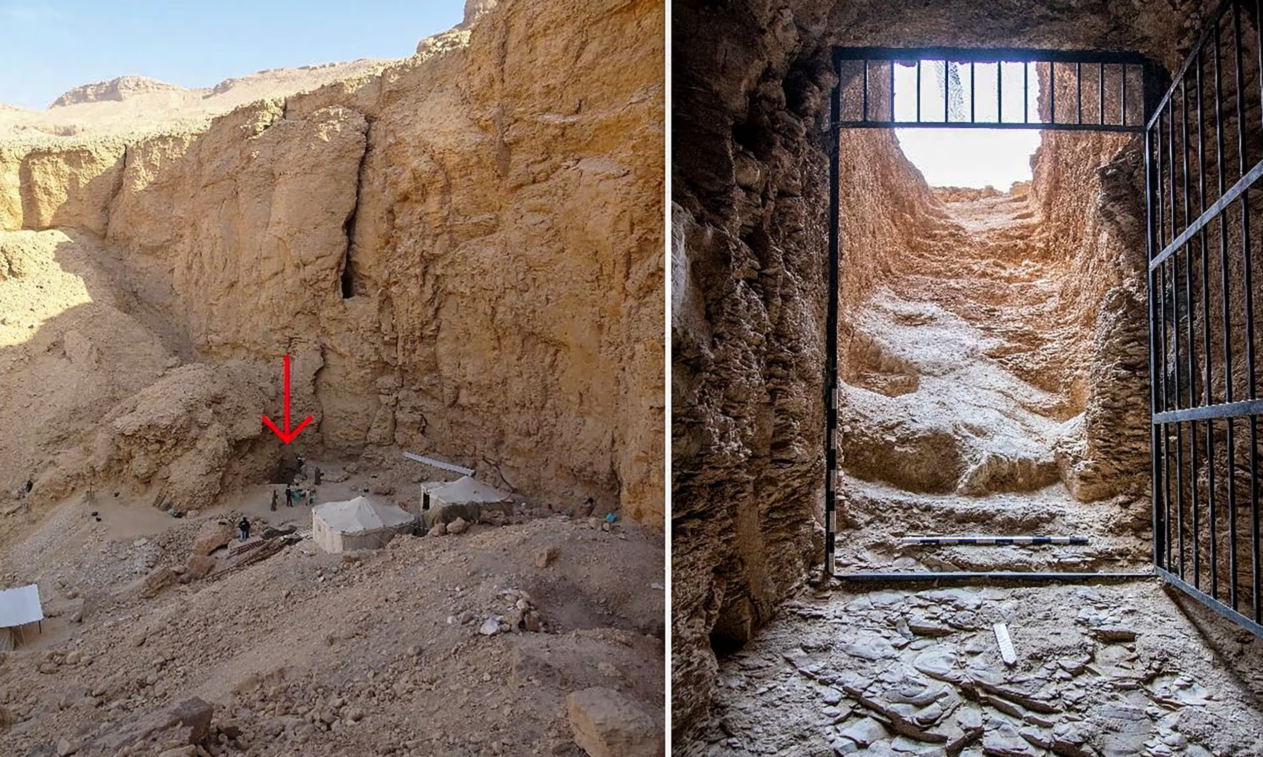
In 2022, a joint Egyptian-British expedition found traces of a staircase leading into the stony depths below a monumental cliff. After months of excavation, they cleared the passageway of rocky debris and emerged into a stark, empty tomb.
There was no sarcophagus or any of the offerings traditional to Egyptian burial sites. Instead, huge limestone chunks clogged the hallways, just like the staircase. But above it all, the ceiling shone with painted stars, and the walls showed scenes from the book of Amduat, reserved for the burials of kings. This had been the tomb of a pharaoh.
So where was he?
Fragments of the old tomb
Scattered among the limestone debris, a few broken fragments of alabaster memorialized the name of the tomb's inhabitant: Thutmose II. Others bore the name of his widow, Hatshepsut.
The debris everywhere didn't align with grave robbers, the common reason for empty tombs. This looked like an orderly evacuation following some sort of disaster. The team concluded waterfalls had pummeled the base of the cliff and flooded the tomb, probably only five or six years after the burial.
But whoever had moved Thutmose II's remains hadn't done so immaculately.
"And thank goodness they did actually break one or two things," commented Dr. Piers Litherland, the lead archaeologist on the team, "because that’s how we found out whose tomb it was.”
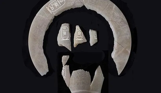
Where was Thutmose II moved?
Egyptologists have known where Thutmose II's body was since 1881. Entombed alongside other royals in the Royal Cache at Deir el-Bahri, Thutmose II had been moved to this communal crypt about 500 years after his death, along with those whose own tombs had also disintegrated.
The French Egyptologist who unwrapped Thutmose II's mummy wrote, "He resembles [Thutmose I, his father], but his features are not so marked and are characterized by greater gentleness. He had scarcely reached the age of thirty when he fell victim to a disease of which the process of embalming could not remove the traces."
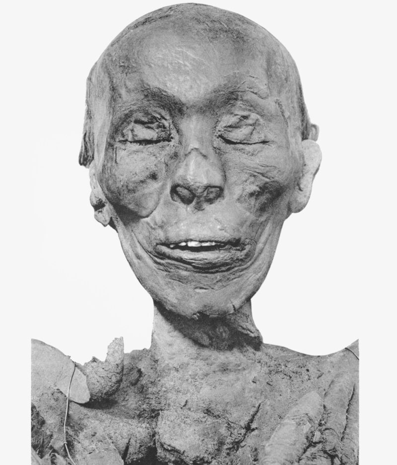
But if a flood destroyed his tomb a handful of years after his death, a second tomb would have had to house his remains and burial gifts for the intervening 500 years before his body wound up in that communal site. If archaeologists can find it, the artifacts within might cast more light on Thutmose II's brief and poorly documented reign.
Hatshepsut, his more famous widow, also stands to benefit should Thutmose II's second tomb be located. Her successor, Thutmose III -- son of Thutmose II by a minor consort -- set to erasing every record of her reign following her death. His motivation was likely revenge over her long reign, which prevented him from taking the throne.
Thutmose II's burial artifacts may contain information on both his reign and the early life of one of Egypt's most iconic but mysterious pharaohs.
Archaeologists have discovered a macabre part of the River Thames's history. For over 6,000 years, humans have been dumping bodies into the London river.
The new study examined 61 skeletons -- 30 newly retrieved ones and 31 previously studied specimens. Radiocarbon dating showed that the remains span a period from about 4000 BC to 1800 AD. A significant chunk of them dates all the way back to the Bronze Age (2300 to 800 BC) and the Iron Age (800 BC to 43 AD). This suggests that the practice was particularly common during these eras.
"These don't appear to just be bones that have steadily accumulated in the river through time,” Nicola Arthur, the study’s lead author, told Live Science. "There really was something significant going on in the Bronze and Iron Ages."
Studying skeletons from the Thames is not new. Since the 19th century, scholars have debated why Britain's early people often threw bodies into the water. One theory is that it was a ritual of some sort. In many ancient cultures, rivers were revered as sacred, and offering human remains might serve to honor deities or to seek their favor. This pattern occurs across northwestern Europe, explained Arthur, but it's still too early to conclude this was the main motivation.
A second theory: The remains may be the result of violence. Not just individual mayhem: Ancient communities would have fought over this vital resource and strategic route. Some of the skeletons pulled from the river show signs of trauma.
Although human remains are not uncommon in European waterways, the sheer number of skeletons discovered in the Thames is unparalleled.
Nurtured by the alluvial planes of the Indus river, the Indus Valley hosted one of the world's oldest urban cultures. From 3300 to 1700 BC, the Indus people built impressive cities like Mohenjo-daro and Harappa, which had the irst urban sanitation systems, developed complex agricultural techniques and massive trade networks, and produced sophisticated art.
They also left more than their share of mysteries. Who were these people, and why did they abandon their vast cities? What sort of government did they have, which allowed for rigorous urban planning but resulted in no palaces, temples, or monuments?
Perhaps the most significant hurdle for those hoping to understand the Indus people is the matter of written language. They probably had one, but that’s another matter of debate. These questions aren’t only important to archaeologists and historians. The Indus Valley civilization is the point of convergence for a number of thorny political and cultural issues.
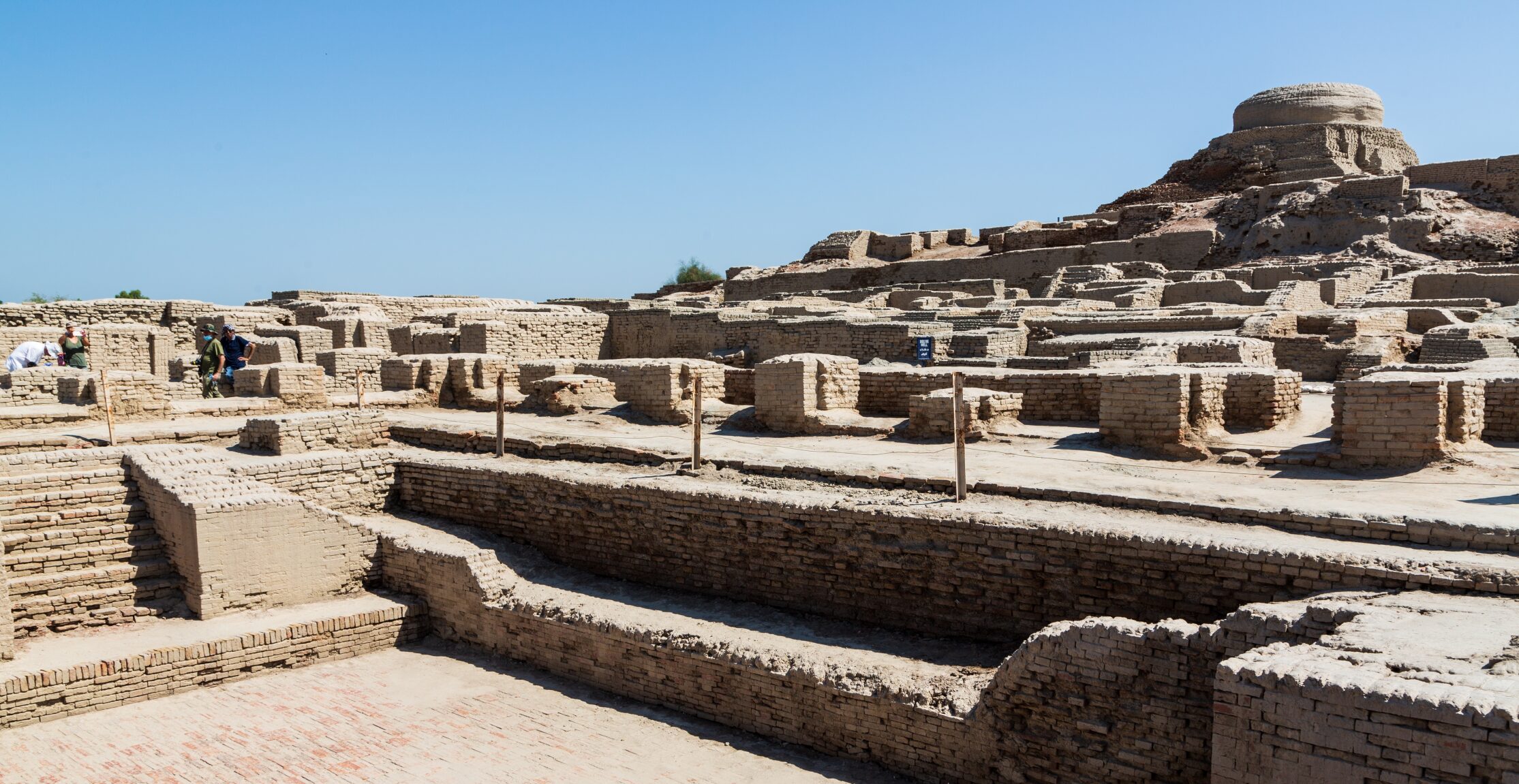
A language mystery
Several political and ethnic groups on the Indian subcontinent are eager to claim descendancy from the Indus Valley people.
Hindu nationalists argue that the Indus script is related to Sanskrit, the ancient language of Hindu scriptures. This was the language of the Aryans, who brought both Hinduism and the Vedic scripts to India. If the Indus writing is related to Sanskrit, they argue, this proves that Aryans are the indigenous people of India the popular philosophy of Hindu supremacy claims.
Another school of thought proposes the script is related to Tamil. Tamil is the classical Indian language of the Dravidian people. If the Indus language is Dravidian, this arguably proves that they are the indigenous Indians.
A recent study brought more attention to the debate. It was a massive joint venture between Pondicherry University archaeologist K. Rajan and R. Sivananthan, deputy director of the state’s archaeological department. Together, they digitized 15,000 pieces of graffiti from over a hundred sites across Tamil Nadu and compared them with the Indus script. According to their findings, over half of the signs were a match, and another ninety percent were “parallels.”
Tamil Nadu is more than 2500 kilometers away from the Indus River valley. If their archaic scripts are indeed related, it would vastly change our understanding of the ancient civilizations of the Indian subcontinent.
The possible significance was not lost on Tamil Nadu chief minister MK Stalin.
“The efforts of the state government is to ensure the right place for Tamil Nadu in the country’s history,” he said.
He issued a statement encouraging anyone to try decoding the Indus script. The successful translator will earn one million dollars.

The trouble with decoding
That’s a lot of money, but it’s a tough job. There exist over 5,000 artifacts in the script, but deciphering them won't be easy. For one thing, it might not actually be a written language. The inscriptions are very short -- most only five symbols, with the longest only 26. They might represent "proto-writing," like early Mesopotamian clay tablets that recorded mercantile transactions. They might even be more like medieval European heraldry, representing a particular group, individual, or family.
Assuming that it is a written representation of spoken language, the language it represents is completely unknown. Other famously decoded ancient languages-- like Linear B or Mayan glyphs-- benefited from known linguistic descendants in modern Greek and Mayan.
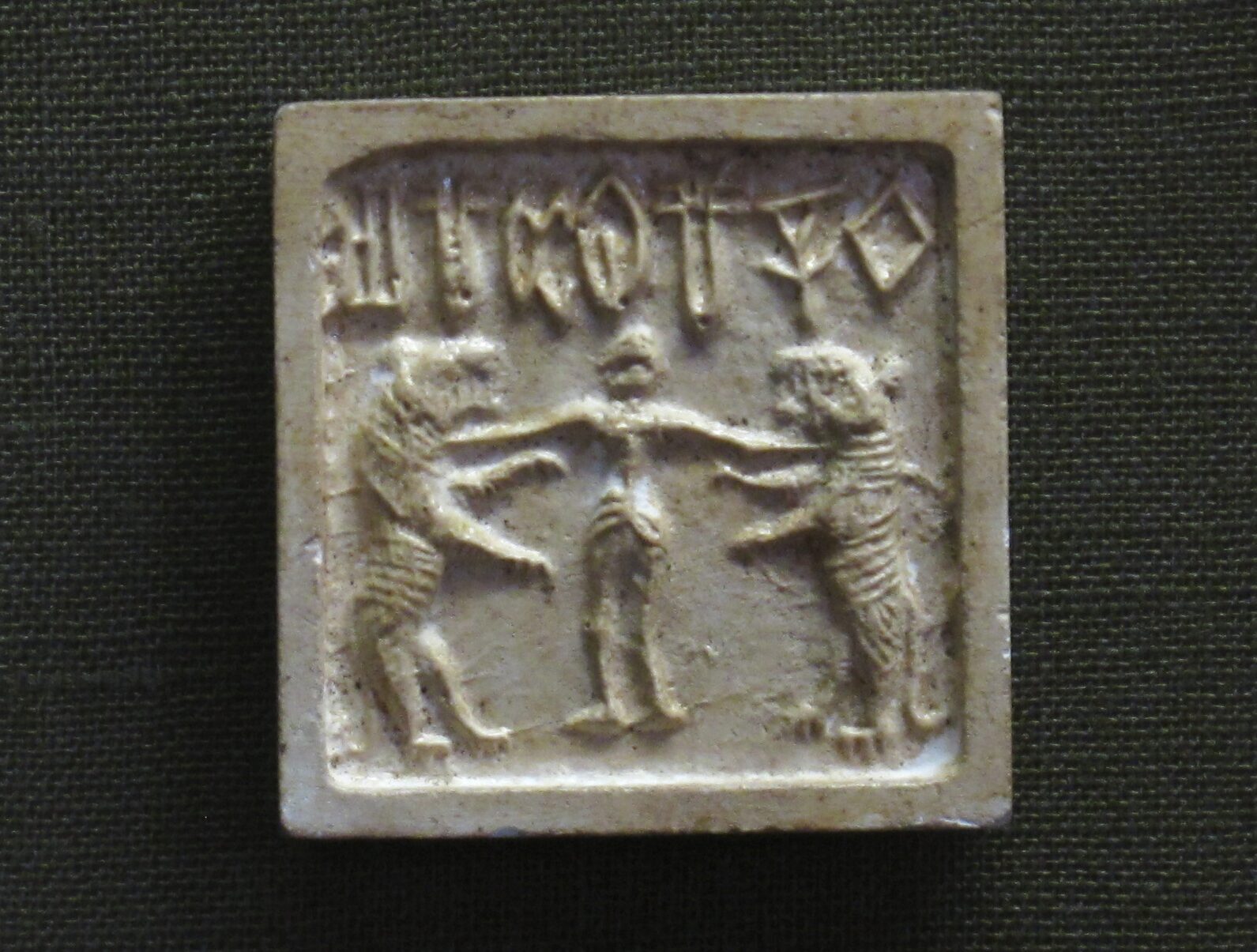
Though the Indus people traded with other literate civilizations, like the ancient Mesopotamians, no bilingual inscriptions have been found. Famously, the Rosetta Stone, written in both Egyptian and Greek, made it possible to decode ancient Egyptian hieroglyphics.
There are as many as 676 unique symbols in Indus script, but a recent computer analysis by Nicha Yadev found that just 67 of them account for 80 percent of the language. Scholars like Yadav are increasingly using computer analysis and machine learning to translate Indus script.
While Yadav has demonstrated an underlying linguistic logic to the signs, he knows that the mystery is unsolved. “We still don't know whether the signs are complete words, part of words, or part of sentences,” he admitted.
So what do the symbols mean? If you can figure it out, you will earn $1 million from the Tamil government.
The eruption of Mount Vesuvius in 79 AD destroyed the Roman towns of Pompeii and Herculaneum and is one of the most culturally important volcanic events in history. The rediscovery of the incredibly well-preserved remains in the late 18th century sparked renewed interest in classical antiquity. It has shaped fashion, art, architecture, and popular culture and has inspired paintings, poems, blockbuster films, and songs.
The eerily preserved bodies are part of what made the catastrophe so famous. But that was not Vesuvius' first major eruption. A new find of fleeing footprints preserved in stone shows another unsettling -- and far older -- record of devastation.
Pipeline work
The discovery only occurred because a gas pipeline near Naples needed updates. In an area so rich in history, any digging requires archaeologists. So researchers and the various companies worked together to preserve what the construction might uncover.
It uncovered a great deal, it turns out. Two years of work on the pipeline have generated an impressive list of discoveries. These include burials from Late Antiquity, votive ceramics from the second and third centuries BC, and a network of ancient roads. It is clear that the area was continuously used over a long period. A Roman villa had at one point been converted into a cemetery, with what researchers believe was an underground martyrium, a buried shrine for Christian martyrs.
The most dramatic find, however, has to be the footprints. Beside a small stream, dozens of tracks from humans and animals are pressed into the stone.
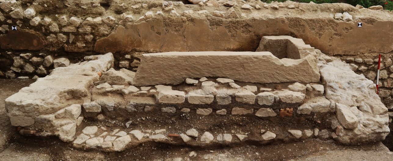
Ancient disaster
Before the Christian cemetery, the Roman villa, and the Hellenic sanctuary, there was a settlement of Bronze Age people. They lived along the banks of a stream called the Casarzano, in the shadow of Vesuvius.
Archaeologists know the footprints were made by people fleeing an eruption because they were preserved in pyroclastic deposits. This is the material ejected from a volcano, like cinders, ash, and chunks of rock and crystal, that blanket the earth during an eruption. Panicked people and their animals fled along the stream, attempting to reach a safe distance, leaving their prints in these deposits.
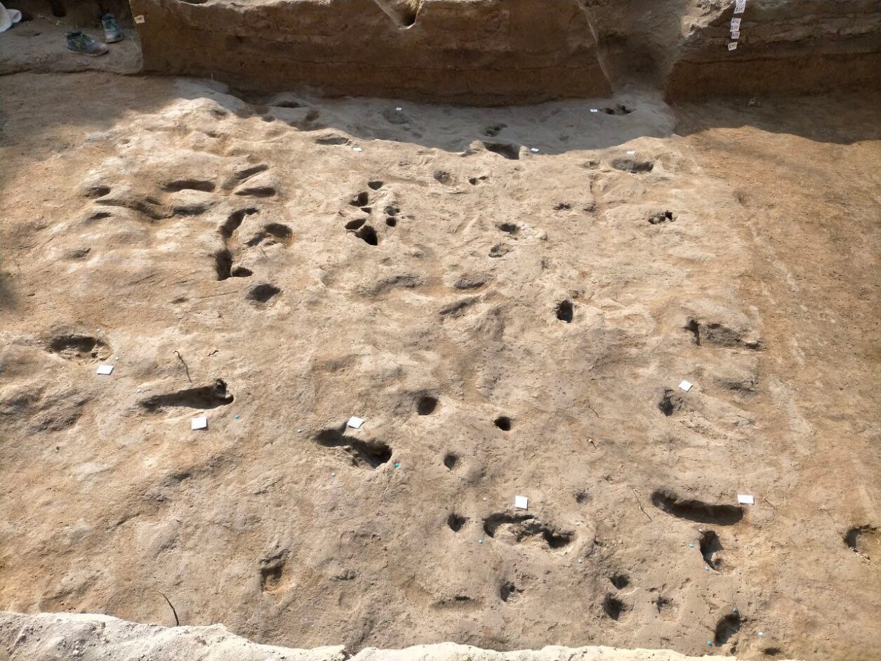
We don’t know whether the people who made those prints survived, but we do know that people returned to the area. Pipeline excavations have also unearthed the remains of a Bronze Age settlement that continued to be inhabited into the early Iron Age.
I am prepared to risk it all by admitting that I enjoyed Indiana Jones and the Kingdom of the Crystal Skull. There it is. The 2008 film didn’t get the best reception because of its overdone CGI and unlikeable characters. But the storyline -- centered on a mysterious, elongated skull from Peru -- grabbed me.
Crystal skulls are some of the most fascinating, strange mysteries out there. They arrived on the archaeological scene in the 19th century, most without stories or context attached. For many years, no one knew who made them or why. But in the early 2000s, they were proven to be fakes, so why do museums still bother to display them?
Where it all began
Our story begins in January 1924. The sound of cutting, cracking and enthusiastic voices interrupted the stillness of the jungle in British Honduras (now Belize). A group of local Mayan descendants, a teenage girl and her dear Papa were searching for something. The father, Frederick Mitchell-Hedges, was on a mission to fulfill his dream of becoming a world-renowned archaeologist after leaving his Wall Street job. And Anna, his protege and adopted daughter, wanted to make a name for herself in the field as well.
Somewhere in the bush was a lost city called Lubaantun, or “the place of fallen stones” in ancient Yucatek Maya. The site was occupied from 730 to 890 AD. At first, it did not look like much, with stones scattered everywhere and the ruins of pyramids. But it would become the epicenter of a phenomenon that took the world by storm.
On finding the ruins, young Anna took this chance to explore for herself without the supervision of her father. While peering through a crack in a sunken temple, she saw a small shiny object glistening in the sliver of sunlight. Risking the unstable ruins, she ventured into the dark and uncovered a skull. Not just any skull. Rather, it was a life-size skull of pure, clear quartz (13cm high, 18cm long, and 13cm wide.) This was her ticket to fame, and the skull soon became known as the Mitchell-Hedges skull.
A supernatural object?
The discovery overjoyed their Mayan guides. Supposedly, it had been missing for centuries and was a big part of their heritage. According to local legends, the skull was a crystallized likeness of a beloved and powerful high priest. To preserve his powers, they crafted the skull after him, believing that his essence could be transferred into the skull. Those in possession of the skull could will death on his enemies.
The most important rule was, don’t look into its eyes. It will drive you mad or even kill you. Curiously, the locals gifted Frederick and Anna the skull as a thank-you. Since then, the skull has been credited by New Agers, shamans, and UFO enthusiasts as the key to hidden knowledge and unlocked psychic abilities. They nicknamed it the Skull of Doom.
Skulls were not uncommon in Mesoamerican cultures. They played a big role in the religious, social, and artistic lives of the Maya and Aztecs. It symbolized both life and death and was mostly associated with human sacrifice, rebirth, and appeasing the gods. Skulls continue to be a major symbol of Mexican cultural practices.
An art restorer named Frank Dorland studied the skull to estimate its value. He determined it was thousands of years old, even older than the site itself. He believed it was carved out of a chunk of quartz, rubbed together, shaped, sanded down, and polished with diamonds for 150-300 years, the time it would take to make it so clear.

Where it gets weird
You would think that such a discovery would have made Anna and Frederick famous as soon as they got back to civilization. Wrong. It wasn't until the 1940s that the skull went public. So why wait? Unless the pair was hiding something.
After her father died in 1959, Anna went into full-on marketing mode. She began to promote events in which patrons could -- for $5 admission -- view the skull, feel its power, and hear about that life-changing find in the jungles of Belize. First red flag! The 1960s and 1970s were the perfect time to start such a venture, as spirituality and New Age exploration were at their peak.
If you check out Frederick's autobiography titled Danger My Ally, you'll see that it does not mention Anna's discovery at all. You’d think that Frederick would have raved about the skull or at least made its discovery public. Rather, there is only mention of acquiring a skull, saying:
It is at least 3,600 years old and according to legend was used by the High Priest of the Maya when performing esoteric rights. When the High Priest willed death, with the help of the skull, death inevitably followed. It has been described as the embodiment of evil. I do not wish to try and explain this phenomenon....
No mention
Why is there no mention of Anna and her find?
Let's look at Frederick Mitchell-Hedges. He was a restless man working in the finance sector, trying to build wealth for himself in London and Wall Street in New York City. Deep down, however, he yearned to be an archaeologist, particularly one who was well respected in the academic community.
Mitchell-Hedges left his well-paying job after saving up £4000 and became a full-time explorer. He had somewhat of a reputation, getting into relationships with wealthy women so he had access to funding for his expeditions. He even claimed that he found artifacts from Atlantis. Surely, such a person would have spoken about this crystal skull.
However, records from the Sotheby's, published in the British journal Man, show a skull -- reputedly an artifact from Mexico -- went up for auction in 1936. The buyer was none other than Mitchell-Hodges. It seemed that he bought the skull, and the whole story of its serendipitous discovery was apocryphal.
The truth comes out
When Anna was confronted with this information, she stated that her father ran into financial trouble and received a loan from an art dealer named Sydney Burney after Mitchell-Hedges gave him the skull as collateral. However, Burney double-crossed him and put it up for auction.
Yet in a letter to his brother in 1943, Mitchell-Hedges suggests that the crystal skull was, in fact, a purchase:
The "Collection" grows and grows and grows. You possibly saw in the papers that I acquired that amazing Crystal Skull that was formerly in the "Sydney Burney Collection." It is fashioned from a single block of transparent rock crystal, exactly life-size; scientists put the date at pre-1800 BC, and they estimate it took five generations passing from father to son, to complete. It is anthropologically perfect in every detail, a superb piece of craftsmanship. There is only one other in the world known like it, which is in the British Museum and it is acknowledged to be not so fine as this.
The matter was eventually put to rest in the 1970s when curious researchers from Hewlett-Packard's laboratories took up Dorland's suggestion to analyze it. Though the lab's technology could not determine its age, it did find signs of metal drills used on its teeth. Anna did not hesitate to take the skull back and refuse any more scrutiny.
Anna's later years
Anna married a man named Bill Homman and they toured with the skull until she died in 2007. Homman became its owner and he took the skull to the Smithsonian in Washington, D.C. for analysis. However, it did not have the answers he was looking for.
Jane Walsh, the main researcher behind the tests, found some interesting details. X-ray and electron microscope scans revealed polishing and tool marks consistent with 19th and 20th-century techniques, particularly those associated with rotary tools and abrasives, most likely with a diamond head. Therefore, this was most likely made in the 1930s.

Ancient civilizations, including the Maya and Aztecs, lacked the technology to carve such precise and smooth shapes from hard quartz. The fact that some skulls displayed features like perfectly symmetrical teeth suggested they were produced much more recently than claimed. Yet...this skull is on display for its expert craftsmanship rather than its historical accuracy.
It's now apparent that the elaborate tale of Anne finding the skull deep in a cave in a jungle in Belize was made up from start to finish. The inconsistencies in her story, conveniently bending the details of her father’s purchase of the skull from an art dealer in London in the 1940s and the lack of records of having been in Belize in 1924 in the first place all point to an elaborate con job.
Other skulls turn up
The Mitchell-Hedges Skull is not the first such quasi-treasure. They've been around since the 1800s. The British Museum’s crystal skull, often referred to as the Mittler Skull, was acquired in 1897 from a collector named Eugene Boban.
A French antiquities dealer, Boban claimed that it had been discovered in Mexico. Most likely, he lied about its age to get more sales. He said it was found in an ancient Aztec or Mayan tomb. Others linked it to the broader lore surrounding pre-Columbian Mesoamerican cultures. However, the lack of solid provenance and the skull's highly polished surface has led many researchers to question its authenticity as a genuine artifact.

When Dr Jane Walsh received another skull in an anonymous package, she couldn't help but analyze it. This one was not life-size but very large, around 31 pounds. It was not an accurate human skull but had more decorative embellishments. She enlisted the help of British Museum scientist Margaret Sax to help her compare the two skulls.
After rigorous tests, she said:
British Museum scientist Margaret Sax and I examined the British Museum and Smithsonian skulls under light and scanning electron microscope and conclusively determined that they were carved with relatively modern lapidary equipment which were unavailable to pre-Columbian Mesoamerican carvers...
The British Museum skull was worked with hard abrasives such as corundum or diamond, whereas X-ray diffraction revealed traces of carborundum (SiC), a hard modern synthetic abrasive, on the Smithsonian skull. Investigation of fluid and solid inclusions in the quartz of the British Museum skull, using microscopy and Raman spectroscopy, shows that the material formed in a mesothermal metamorphic environment equivalent to greenschist facies. This suggests that the quartz was obtained from Brazil or Madagascar, areas far outside pre-Columbian trade networks.
Conclusion
So, where does this leave us? They're fake, yes. But you can't help but admire the craftsmanship and beauty of the pieces. In a way, its creators got what they wanted: fame of a sort.
Archaeologists have unearthed a 4,000-year-old tomb in Saqqara, Egypt that belonged to Teti Neb Fu, a royal witch doctor. Sitting 40km south of Cairo near Giza, Saqqara is an ancient burial ground for high-ranking officials.
The team has been excavating the southern side of the site, where the tomb is located, since 2022. Saqqara is the location of the very first Egyptian pyramid and is renowned for its association with Egypt's earliest dynasties.
The burial chambers, known as mastabas, held particularly important people. Teti Neb Fu's tomb is remarkably well-preserved in some ways, although almost everything within it had been looted before it was uncovered. There were also no bones within the grave.
Instead, researchers identified who the tomb belonged to by the inscriptions and carvings on its intricately decorated walls. These not only name the man who once lay within but also give some clues about the magician's life.

Snake doctor
Teti Neb Fu lived in Ancient Egypt’s Sixth Dynasty during the rule of King Pepi II. The inscriptions show that he held several prestigious titles. These include the Chief Palace Physician, Chief Dentist, Priest and Magician of the Goddess Serket, and the Director of Medicinal Plants. These all suggest he served as both a healer and a magician, blending medical knowledge with spiritual practices to treat ailments within the pharaoh’s court.
One of the most intriguing aspects of Teti Neb Fu’s career was his knowledge of how to treat venomous bites and stings. Researchers believe this might have been his specialty because of his association with Serket, the goddess of protection, healing, and magic. Often depicted with a scorpion on her crown, she was known for healing their venomous bites.
Muhammad Ismail Khaled, the Secretary General of Egypt's Supreme Council of Antiquities, thinks the list of intriguing titles reveals a lot about the beliefs within ancient Egypt's Old Kingdom. The references to medicine, magic, and religion show that these practices, while odd bedfellows in our era, complemented each other in ancient Egypt.
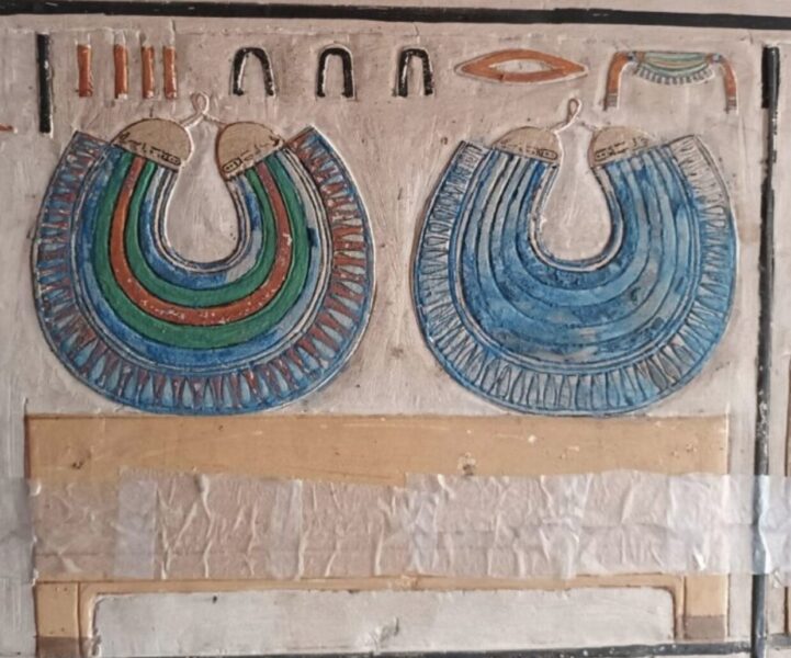
Elaborate tomb
The elaborate tomb reflects Teti Neb Fu's prestigious position. Its walls are covered with carvings of healing scenes and rituals and hieroglyphs describing his work.
“The tomb is adorned with stunning carvings and vibrant artwork, including a beautifully painted false door and scenes of funerary offerings,” the Egyptian Ministry of Tourism and Antiquities said in a statement.
The discovery of Teti Neb Fu’s life as healer and magician of the pharaoh’s court provides a deeper understanding of early Egypt. Archaeologists have previously found tombs belonging to the wives and senior officials of King Pepi I, but this is the most intriguing find so far.
Archaeologists have uncovered the long-lost site where Alexander the Great achieved his first major victory in battle. It took place against the Persians in 334 BC, and marked the start of the 21-year-old general's campaign to conquer Asia Minor.
New evidence suggests that the battlefield lies near the modern-day Biga River in northwestern Turkey.
Turkish archaeologist Reyhan Korpe has been searching for the site of the so-called Battle of the Granicus for two decades.
“The Battle of the Granicus is considered one of the most pivotal moments in world history," he told Turkiye Today. "Following his victory here, Alexander conquered...much of Asia, extending his empire into India."
The battle of 90,000 men saw Alexander's Macedonian army face the formidable Persian force for the first time. The Persian ruler Darius was warned not to meet the Macedonian army head-on, but he ignored his advisers.
This marked the first of three battles between the Persians and Alexander's army across Asia Minor. The Battle of the Granicus began the fall of the Persian Empire.
Two decades of research
The exact location of this historic battlefield had eluded searchers for centuries. Korpe and his team analyzed ancient texts, did extensive fieldwork, and even did geomorphological analysis to map Alexander's route through the region. After two decades of meticulous research, they finally pinpointed the location of the battle.
In the 19th century, German geographer Heinrich Kiepert suggested this site as the location but offered little evidence to support his claim. For Korpe, the key was finding the remains of the ancient city of Hermaion, cited as Alexander’s final stop before the battle.
Ancient sources also state that some of Alexander's men positioned themselves on a hill during the battle. Farmers have found ancient remains and weapons on a hill next to the proposed battleground.
“The most important discovery was identifying the routes Alexander took to reach the battlefield and where he camped along the way," explained Korpe. "We mapped out the exact route Alexander traveled."
Turkey's Ministry of Culture and Tourism plans to develop the site into a tourist attraction.
Archaeologists think they have identified the ship that took Vasco da Gama on his final journey into the Indian Ocean. Initially discovered in 2013, researchers believe the wreck off the coast of Kenya is da Gama’s 16th-century Sao Jorge.
The Portuguese explorer took a pioneering route from Europe into the Indian Ocean. He was the first person to link Europe and Africa via the ocean and the first to sail around the Cape of Good Hope, the southernmost tip of Africa. This was the starting point for Portuguese trade in the Indian Ocean.
Da Gama made four journeys to the Indian Ocean throughout his life. The last, in 1524, featured an armada of 20 ships, including the Sao Jorge.

Just six meters deep
The Sao Jorge sank later that year, shortly before da Gama died. If the researchers are correct, then this is one of the earliest European shipwrecks in the Indian Ocean. When originally discovered in 2013 just six meters below the surface, divers found copper ingots and elephant tusks around the submerged ship, as well as timbers from its hull.
“The provisional dates of the artifacts point to a shipwreck on the outward journey to India and a shipwreck date in the first quarter of the sixteenth century,” the researchers said in a statement.
To confirm that it is da Gama’s ship, the team will now carry out archaeological surveys of the nearby coral reefs. These stretch 25 kilometers from the beach resort town of Malindi, where the wreckage lies, to a cape called Ras Ngomeni.
Filipe Castro, a nautical archaeologist leading the study, admits that they still aren't sure if the wreckage belongs to the Sao Jorge, but if so, "it is a treasure."

There are several Portuguese shipwrecks from the same time period around Malindi. In the early 1500s Portugal started creating galleons -- ships that could be used both in war and for exploration of the Indian and Pacific Oceans. Each had three or four masts and could be fitted with artillery in several places. The design was copied across Europe and “changed the history of European expansion," said Castro.
Archaeologists have uncovered the oldest alphabet in human history. Small clay cylinders from an ancient Syrian tomb show clear markings of letters etched into them.
Using carbon dating, researchers have established that the pieces of clay and the tomb they were in date back to 2400 BC. This means the writing predates other early alphabets by 500 years. This completely changes our belief about the origins of alphabets in early civilizations. Most experts had credited the ancient Egyptians with the invention of the alphabet around 1900 BC.
“Alphabets revolutionized writing by making it accessible to people beyond royalty and the social elite," said Glenn Schwartz, who led the recent study. "Alphabetic writing changed the way people lived, how they thought, how they communicated. This new discovery shows that people were experimenting with new communication technologies much earlier and in a different location than we had imagined.”
Schwartz has led a 16-year excavation at Tell Umm-el Marra in western Syria. Tombs dating back to the Early Bronze Age contain skeletons, jewellery, and pottery. One also held the finger-sized pieces of engraved clay.
It is possible the little clay pieces were labels. They all have small perforations, indicating they were once tied to other objects.
“Maybe they detail the contents of a vessel, or maybe where the vessel came from, or who it belonged to,” said Schwartz. "Without a means to translate the writing, we can only speculate."
Schwartz presented the findings at the annual meeting of the American Society of Overseas Research earlier this week. He and the research team are investigating how smaller cities and urban areas developed across Syria. The Tell Umm-el Marra site was one of the first medium-sized centers in the region.
For over 30 years, starting in the 1940s, hundreds of tons of surplus ammunition was dumped into Lake Mjøsa, Norway's largest lake. In 2022, a military vessel used an autonomous underwater vehicle to map the dumped bombs. What they found, instead, was a strikingly well-preserved shipwreck.
The sonar image it captured excited marine archaeologist Oyvind Odegard, who was working on the project. But without more information, it was impossible to determine when the ship had been built or what secrets it held.
Exciting find
"This shipwreck is the most exciting find we've encountered so far,” said Mjøsa Museum director Arne Julsrud Berg. He has completed nearly two dozen dives in Lake Mjøsa, investigating the remains of 18th and 19th-century ships. But those lay at depths of less than 20m. This one is more than 400m down -- too deep for divers.
Instead, researchers from the Norwegian University of Science and Technology (NTNU), led by Oyvind Odegard, sent down a remotely operated underwater vehicle (ROV). It was equipped with a grabbing arm and attached to a boat by a long line.
The icy depths presented significant technical challenges on the first expedition in 2023. The robot could only capture a few seconds of video before losing power.
In late 2024, after spending the intervening year ironing out the kinks in their intrepid little robot, they tried again.
While the cold, placid lake bottom preserves sunken ships (and bombs), the surface can be treacherous. Bad weather forced researchers to pull the robot back up before it could collect a sample that would allow them to carbon date the ship.
But they did get incredible photos and video footage of the wreck, which provided researchers with tantalizing clues to its history.

Meet Storfjorden I
Researchers call the ship Storfjorden I, and thanks to new footage, they now believe it is a type of flat-bottomed vessel called a "føringsbåt." These were used to carry passengers and cargo across the lakes of Norway for hundreds of years.
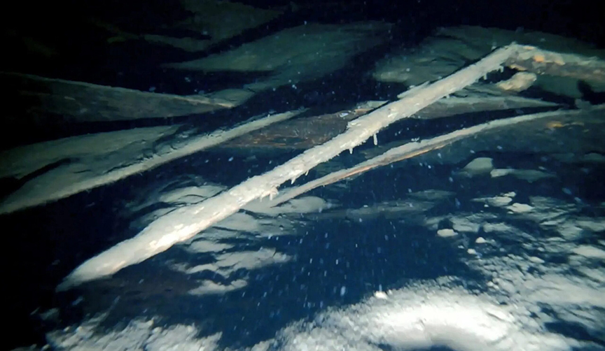
Viking or Victorian?
Although its name means Big Fiord in Norwegian, Storfjorden -- just 10m long -- isn’t large enough to be considered a ship. Initial estimates placed Storfjorden anywhere between the 3rd to 4th centuries and 1850. The same conditions which kept the boat intact also make it difficult to date. With a wreck this well-preserved, researchers can’t use the rate of decay to judge its age. So without rot and without a sample, they must use the clues of its construction to narrow down a timespan.
The boat is “clinker” built, meaning the planks are overlaid in the traditional Scandinavian style. Later vessels would be “carvel” built, a style of laying planks down flush that originated in the Mediterranean.
Starting in the late 1700s, the sawed planks for ships came from a shipyard. But these planks were cut thickly with an ax, confirming suspicions that this was an older find. But how much older? Could it date back to the Viking age?
Again, visual clues in the footage provide a tentative answer.
The boat had an upright stern, which in Norway only began around the end of the 14th century. Another hint is how it was steered. Unlike earlier Viking ships, which used a special steering oar over one side of the vessel, this føringsbåt appears to have a central rudder.
But beyond these new ranges, the precise age of the boat still remains to be seen.
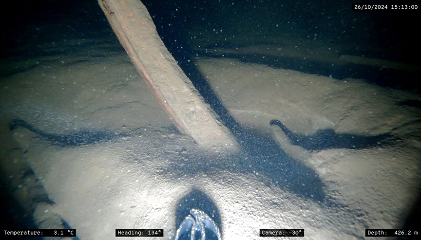
Future discoveries
Work has only just begun on the bottom of Lake Mjøsa. Odegard and his team plan to go out to the føringsbåt wreck site again next year, and it is likely only the first of many discoveries in the lake.
Another group of NTNU researchers is making a digital map of the lakebed, which integrates satellite, historical, and research data as well as other measurements.

Lake Mjøsa has been used as a waterway since at least the early medieval era and much of it remains unexplored. In his early years, the great Norwegian polar explorer Otto Sverdrup applied for a job as a ferry captain on Lake Mjøsa.
Sverdrup, who later became the greatest ice navigator of the Golden Age of Polar Exploration, did not get the job because "the company was not willing to take on a man who was unfamiliar with the difficult ice conditions on this lake," says Sverdrup's biographer, Per Egil Hegge.
Scientists have brought a vampire back from the dead with 3D printing and modeling clay. Found in an unmarked cemetery in Pien, Poland in 2022, her grave shows all the signs of a burial of someone considered a vampire.
Called Zosia by locals, the girl was buried with an iron sickle across her neck, padlocks around her feet, and a few different types of wood around her. Her remains date back 400 years.
At that time, all three items were believed to protect humans from vampires. Slavic folklore tells that sharp objects such as sickles would decapitate the dead and stop them from returning to the living world. Other such vampire burials in Poland include sickles or padlocks. This is the first time that archaeologists found both in a single grave.
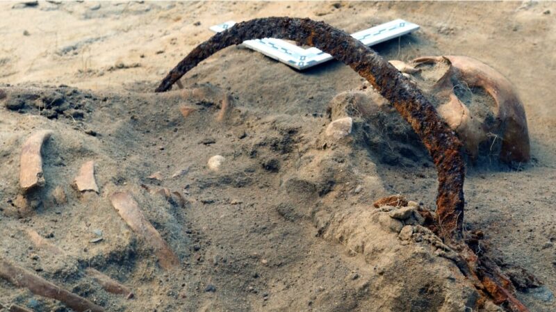
Resurrected as a human, not a monster
To reconstruct her face, archaeologist Oscar Nilsson first 3D-printed a replica of Zosia’s skull. Then he added layers of modeling clay to build up her face bit by bit. Analysis of her bone structure, gender, age, ethnicity, and weight helped replicate her exact features.
"It's emotional to watch a face coming back from the dead," Nilsson told Reuters. "Especially when you know the story of this young girl."
He said the team wanted to bring Zosia back to life "as a human, and not as this monster that she is buried as."
During the 17th century, superstitions were rife. Anyone who behaved differently, had a disability, was born out of wedlock, or was foreign could be accused of witchcraft or supernatural connections. Unusually, Zosia’s grave shows signs of relative wealth within her community, including fragments of silk and precious metals. This intrigued the researchers even more.

The mystery of Zosia
Dariusz Polinski, who led the excavations, told The Past, “She was neither ritually murdered nor was she one of the convicted in the witchcraft trial. Those individuals were treated in a different way, and they were usually thrown into provisional graves. It is possible that in her lifetime, the woman experienced a tragedy and was harmed. On the other hand, her appearance or behavior might have provoked contemporary residents to be afraid of her.”
Anthropologists, archaeologists, and forensic experts have been working to uncover who Zosia was and what she looked like. She died between the ages of 17 and 21, had Swedish origins, and suffered from a hemangioma on her chest. These are growths of blood vessels on the skin that may have been visible to others. They can cause dizziness, fainting, and extreme headaches. This would likely have been viewed negatively by those around her and added to the belief she was a vampire.
Known as the Treasure of Villena, this horde of brilliant golden treasure from prehistoric Spain reveals ancient metalworking secrets.
Amid a dazzling collection of 66 mostly golden artifacts, the two most important ones are not the most eye-catching. But this open iron bracelet and gold-decorated iron hemisphere are more than they seem.
In a recent paper, researchers at Spain's National Archeological Museum discovered that the objects were forged from meteoric iron.
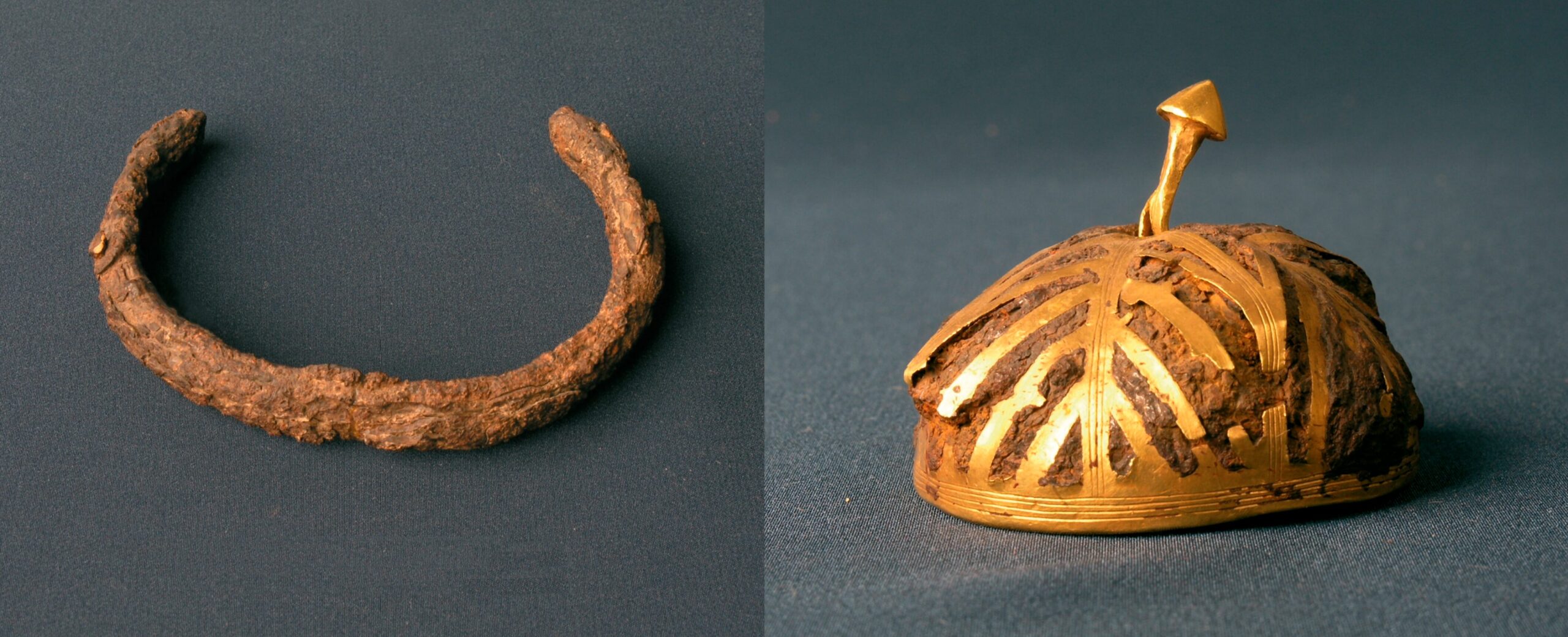
Bronze Age or Iron Age?
The Treasure of Villena, discovered in the Valencia region of Spain in 1963 by Jose Maria Soler, is considered one of the most important collections of prehistoric treasure in Europe. Yet for 60 years, researchers have struggled to accurately date the collection. Estimates spanned nearly a thousand years, from 1500 to 800 BC.
The sticking point was two worked pieces of iron, the hemisphere and the bracelet. While the gold objects that made up the bulk of the collection were dated to between 1500 and 1200 BC, smelted terrestrial iron objects weren’t produced on the Iberian peninsula until around 850 BC.
Metal from the sky
But what if these objects weren’t made of terrestrial iron? It wasn’t as unbelievable as it might seem. In fact, the oldest known iron artifacts, a set of 5,000-year-old beads from northern Egypt, also came from meteoric iron.
Iron is almost always found in the form of iron ore, which needs to be treated to extract the iron. Without the invention of this process, called smelting, Bronze Age peoples couldn’t use the iron they found. But they could harvest iron from meteorites to make weapons, tools, and decorative objects. Meteoric iron is easily distinguished from terrestrial iron: It has more nickel and less carbon.
Researchers tested the Villena iron objects by carefully taking small samples so they would not damage the precious artifacts. What they found seemed to confirm their suspicions. These ancient treasures came from a fallen meteorite.
Due to the corroded condition of the artifacts, the results aren’t completely certain, but further tests should confirm their initial analysis. If so, these objects are the first examples of meteoritic iron working on the Iberian peninsula. It would also affirm that the Treasure of Villena belongs to the Bronze Age, suggesting a date of around 1400 to 1200 BC.
Researchers think they have found a depiction of Noah’s Ark on the 3,000-year-old Babylonian Map of the World. Also known as the Imago Mundi, the clay tablet has baffled archaeologists for over a century.
Archaeologist Hormuzd Rassam discovered the tablet in 1882 in Sippar, an ancient Babylonian city in present-day Iraq. It now lies in the British Museum, and researchers finally think they have decoded it. Curator Irving Finkel says that the cuneiform writing on the tablet tells of the ancient Babylonians' beliefs and culture.
The tiny tablet has cuneiform on both sides and a map of sorts etched into it. The writing above the map tells of the creation of the Earth, and the map itself seems to give an aerial view of Mesopotamia.
On the tablet, Mesopotamia is surrounded by a double circle that is labeled the "Bitter River." At the time of creation, this was considered the boundary of the known world. Within Mesopotamia, clear markings depict the Euphrates River, Babylon, and other features.
“In this circular diagram, you have captured the entirety of the known world, where people lived, thrived, and perished,” said Finkel.
Triangles outside the double ring represent distant mountains and realms beyond that of the known world.
Mysterious triangles
The back of the tablet is covered in cuneiform, which speaks of what lies within the eight triangles that sit outside the double circle. Here, the information slips between reality and imagination. Those creating it did not know exactly what lay beyond Mesopotamia. The stories tell of giant birds and trees with jewels hanging from them instead of fruit.
Researchers think the back acts as a guide to unknown lands for any explorer who is considering a journey beyond the Bitter River. A story about one of the mysterious realms shows a striking resemblance to the biblical tale of Noah’s Ark. It says that the explorer must pass through "seven leagues...[to] see something thick as a parsiktu-vessel."
The word parsiktu was of immediate interest to Finkel. He says this word would make any Assyriologist's ears prick up. It is only seen on one other cuneiform tablet, which describes an ark built by the ancient Babylonian version of Noah. The Ark eventually crashes on the other side of a mountain beyond the Bitter River.
Finkel believes the Imago Mundi tells adventurers the journey they must take to find Noah's Ark and gives us an incredible insight into the crossover of ancient stories and cultures.
“It shows that...from the Babylonian point of view, this was a matter of fact…That if you did go on this journey, you would see the remnants of this historic boat,” he says.
Researchers have sequenced the oldest known genome in Italy. It belongs to a blue-eyed, dark-skinned, curly-haired little boy who lived during the last Ice Age.
Archaeologists discovered his skeleton in 1998 in the Grotta delle Mura cave in Puglia, the region at the heel of Italy's "boot." Carefully placed between slabs of rock, it was the only burial in the cave. The well-preserved remains of the little boy offered researchers a rare glimpse into infancy during the Upper Palaeolithic era.
The infant was 76cm (two-and-a-half feet) tall when he died. Dental analysis suggested he was around 16 months old. His remains indicate he was poorly developed, and his teeth show nine lines that are markers of stress. Clearly, the boy's short life was a difficult one.
Isotopes within the tooth enamel gave most of the information. The strontium suggested that the mother was malnourished and stayed in one place during pregnancy. A fracture in the child's collarbone indicates his birth was very difficult.
Born with ill health
DNA analysis proves that the child had ill health throughout its short life. Mutations were present in two genes, TNNT2 and MYBP3, signaling that he suffered from the genetic condition of hypertrophic cardiomyopathy which eventually leads to congestive heart failure -- his likely cause of death.
Radiocarbon dating shows the child lived between 16,910 and 17,320 years ago, not long after the Last Glacial Maximum. At this time, ice covered a quarter of the land on Earth.
The boy existed in a time of significant change, and this find offers information on ancient human migration into southern Italy. The region's climate was slightly warmer than other parts of Europe, which made it a slight refuge from the harsh conditions in other parts of continental Europe.
Genetic analysis shows the boy was an ancestor of the Villabruna cluster, a group of post Ice-Age people that lived until about 14,000 years ago. His connection to them proves that their lineage began in southern Italy before the end of the Ice Age. It is the first time that researchers have been able to say without question that the group was in the region before the Ice Age ended.
For centuries, a lost Mayan city was buried under dense jungle in southeastern Mexico. The massive site, named Valeriana after a nearby lagoon, covers over 16 square kilometers. With an estimated 6,764 man-made structures, only the Calakmul site, 100km away, rivals its size.
Despite the fact that it only lay a short hike from the town of Xpujil, the archaeological community was unaware of this ancient metropolis hiding in the neighborhood.
Tulane University PhD researcher Luke Auld-Thomas discovered it by chance. Digging around the internet, he found a laser survey completed by a Mexican environmental monitoring organization, “on something like page 16 of a Google search.”
No other archaeologist seen this. Auld-Thomas processed the data again, this time using the parameters of his trade developed by the National Center for Airborne Laser Mapping.
The result was a detailed map of a sprawling lost city.
Founded before 150 AD
Even without fieldwork, the layout gives archaeologists a glimpse of what life would have been like in Valeriana. At its peak, between 750 and 850 AD, 30,000 to 50,000 people lived there. The city center included several temple pyramids, a ball court, enclosed plazas connected by a causeway, a reservoir and amphitheater-style residential patios. Architectural details reveal that the city was founded before 150 AD, and that the entire site was part of a continuous urban sprawl.
To the southwest of the city center lies a more modest residential area. Here, ring-shaped structures revealed that the people who lived there had been producing lime plaster.
The epicenter of the site is on the edge of the area covered by available data, making it extremely likely that there are more buildings just outside the scanned section.
This discovery is a reminder that in the pre-colonial era, complex civilizations lived in the tropics.
“No, we have not found everything, and yes, there’s a lot more to be discovered,” Auld-Thomas said.
On every level, this discovery runs counter to the old colonial idea of the Americas as a lightly inhabited wilderness.
The future of discovery?
Valeriana also shows us the changing methods of archaeological discovery. Light detection and ranging technology (LiDAR) penetrates dense vegetation. It can search huge, inaccessible areas for possible sites. Until now, its prohibitive cost has limited its use. However, as Luke Auld-Thomas has proved, archaeologists can repurpose so-called ‘found’ datasets from unrelated remote sensing work.
Who knows what ancient, undiscovered wonders are still out there, hidden in old civil engineering reports and ecological surveys?
The Sverris Saga tells the old Norse story of King Sverre Sigurdsson, his rise to power, and his rule over Norway from 1184 to 1202 AD. One anecdote in the book speaks of a dead man who was cast into a well before it was filled with stones. Hundreds of years later, researchers think they have discovered the remains of this nameless Well Man.
He is only mentioned in one line of the saga but is now one of its most famous characters. This is the first time that actual remains have been linked to a Norse saga. Researchers discovered the bones decades ago, in 1938, in a well at Sverresborg Castle -- the well described in the saga.
At the time, the technology to fully analyze the bones and identify the individual did not exist. Now, a joint team from Scandinavia, Iceland, and Ireland has carried out genomic analysis, radiocarbon dating, isotope analysis, and gene sequencing of the skeleton.
The team extracted DNA from the leg bone and cranium. “We were very frustrated to find that it was almost entirely bacterial DNA,” said co-author of the new study, Michael Martin. Most of the human DNA was severely degraded. Everything changed when they got some teeth from the lower mandible. The root of one tooth held enough DNA that they could sequence the man's genome.
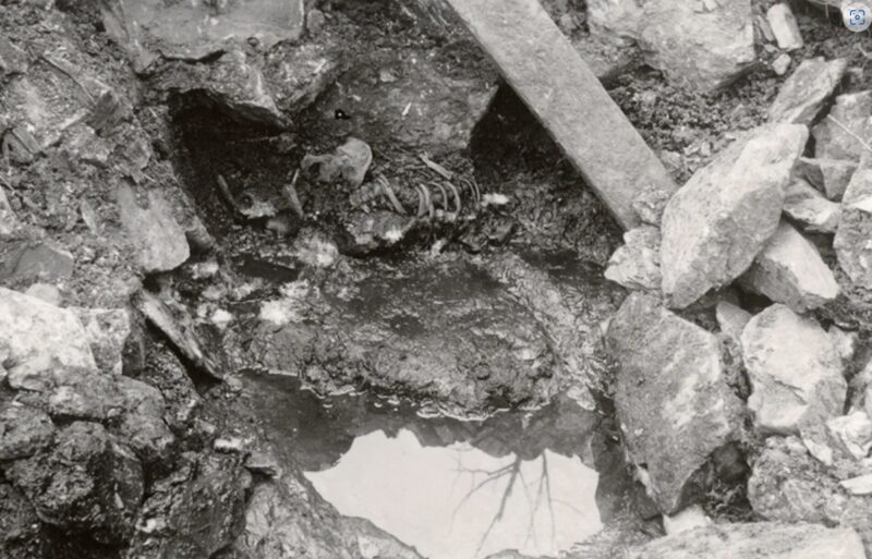
Timeline fits
The team has been piecing together information about the mysterious Well Man for six years. When he died, Well Man was between 30 and 40 years old and had blue eyes and blonde hair. His genetics trace back to Vest-Agder, a southern county of Norway. Isotopes of carbon and nitrogen suggest a seafood-rich diet.
Crucially, he died approximately 900 years ago. This timeline fits perfectly with the story of the invasion of Sverresborg Castle in the Sverris Saga.
The tale recounts that in 1197 AD, the archbishop’s fighters invaded the castle when the king was not there. They did not kill anyone but burned down all the houses and destroyed the castle and all of the king's longships. Then the archbishop’s men took a dead man and threw him into the well before filling it with stones. Co-author Anna Petersen said most scholars think the man was either important to the king in some way or they were trying to poison the castle’s water supply.
No one will ever truly know what happened. They do know that the man was dead before he was thrown into the well. How he died is a mystery. Though the saga says no one was killed during the invasion, that might not be the case.
"The text is not absolutely correct," said Petersen. "What we have seen is that the reality is much more complex than the text."
Martin agreed. “The sagas," he pointed out, "are a mix of historical fact, storytelling, political propaganda, and Old Norse religion.”
Archaeologists have mapped two lost cities of the Silk Road in Uzbekistan using drones and LiDAR. The fabled cities had lain buried under mountain pastures for centuries.
Light detection and ranging technology (LiDAR) uses laser pulses to detect structures hidden beneath vegetation. The two settlements lie five kilometers apart at around 2,000m above sea level. Called Tugunbulak and Tashbulak, they were two of the largest mountain settlements on the famous trade route between Europe and China.
Tugunbulak, the largest of the two, contains watchtowers, plazas, fortresses, and large complexes. Tens of thousands of people once lived here.
Speaking about Tugunbulak, Farhod Maksudiv -- co-author of a new paper on the find, said, “The people inhabiting Tugunbulak for more than a thousand years ago were nomadic pastoralists who maintained their own distinct, independent culture and political economy.”
Backyard find
The research team has been uncovering the Tashbulak site for almost a decade. In 2015, a forestry official commented that he had seen ceramics in his backyard that were similar to what they were unearthing at Tashbulak. This tiny tip is how Frachetti discovered the larger Tugunbulak site.
“We got down there, and right in his backyard is a medieval citadel," Frachetti told CNN. "He just didn’t know it. We go up to the mound, and we look out, and we can see mounds and pyramidal [shapes] all over the place, and we’re like, oh my gosh, this place is huge."
At first, they used foot surveys and computer modeling to figure out the layout of both sites. It took a long time, but this proved to be a silver lining. Over the years, the technology has improved tenfold, and now they can use LiDAR and drones.
Drone use is strictly regulated in Uzbekistan, and the team needed special permission to use them. This year, they finally mapped out both cities, thereby discovering the largest urban layout of any medieval Central Asian city at high altitude.
“The final high-res maps were a composite of more than 17 drone flights over three weeks,” Frachetti said. “It would have taken us a decade to map such large sites manually.”

High-altitude hubs
The research proves that the Silk Road did pass through high-altitude areas. Some have speculated that it only wandered through the lowlands. The Silk Road was such a commercial success that setting up settlements along its branching paths was incredibly lucrative, and cities began popping up along it.
Despite this, the archaeologists believe these settlements existed for a different reason. Life at this altitude would have been incredibly difficult, making it an odd choice for a simple stopover along the route. They are also much larger than other rest stops.
Instead, the team thinks they were built to harvest the nearby iron ore. They hope that future excavations will reveal who built the cities and why they were abandoned.
Underwater caves off the coast of Sicily offer new clues about the island's first human inhabitants. They may have arrived by sea, not by land, as previously assumed.
Sicily is one of the earliest islands in the Mediterranean that modern humans inhabited. How they reached it is a mystery. Though it sits just over three kilometers off the coast of Italy, crossing that stretch of water was not easy.
Most of the work on Sicily’s ancient history has focused on land. But archaeologist Ilaria Patania and her team studied submerged caves in southern Sicily instead. Tens of thousands of years ago, these were on dry land, but rising sea levels have since covered them.
Patania and her team worked closely with local divers, fishermen, and even retired tugboat captains who had spent years in the waters around Sicily. Their insights helped researchers locate previously overlooked sites. Archaeologists also collaborated with the Italian navy’s specialized dive teams to explore deeper underwater areas.
Initially discovered in 1870 and lightly investigated in the 1990s, the caves have been almost forgotten since then.
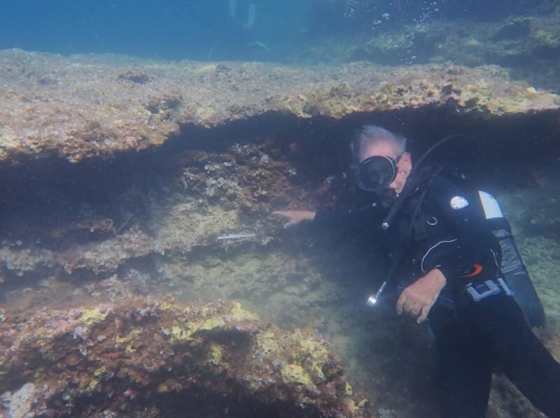
Land bridge
The team searched the underwater caves for signs of early human presence. One site of particular interest is the Corruggi cave near the southern tip of Sicily. A land bridge once connected this to the island of Malta, so early humans could have walked between the islands.
"Analyzing the remains from this site might give us insight on the very last leg of the human journey [from] the southernmost coast of Sicily and off toward Malta,” said Patania.
Inside the Corruggi cave, researchers found animal fossils, pottery, and ancient stone blades, suggest that early humans were active in this region. They may have traveled either by land, water, or both -- island-hopping across the Mediterranean.
Researchers tend to agree that ancient humans arrived in the area 16,000 years after the last glacial maximum. But we know humans had made it to Siberia 30,000 years earlier. The huge discrepancy in time scales is baffling. Many now wonder if our ancestors arrived in Sicily much earlier than we thought.
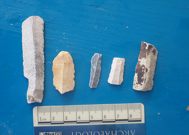
In 1934, an archaeologist was digging in the Timna Valley in the sweltering heat of southern Israel. He was trying to prove that King Solomon's Mines was no mere 19th-century fantasy adventure. He believed it was real.
Background
The fascination with biblical archaeology traces back to the Victorian era. With the Industrial Revolution came excavations and the discovery of long-buried sites like Troy, Mycenae, and Nineveh. Some of these discoveries even confirmed tales of Greek mythology and the Bible. The excitement permeated Victorian culture and led to the emergence of adventure fiction.
Enter H. Rider Haggard
The story of King Solomon’s Mines originated in H. Rider Haggard's novel of the same name. This son of a barrister could not figure out what he wanted to do in life. After failed attempts to get into both the army and the British Foreign Office, his father shipped him off to South Africa to work as a personal assistant to a celebrated diplomat. Thus, his love affair with adventure began. Africa and its ancient legends fascinated him. He published King Solomon’s Mines in 1885, and it was an instant hit.
In the novel, he introduced Allan Quatermain, an Indiana Jones-like character who also featured in subsequent novels. Here, a man named Sir Henry Curtis enlists Quatermain for his hunting skills and knowledge of a dangerous region to help find his lost brother.
Curtis’s brother disappeared while trying to find the fabled diamond mines of King Solomon. After narrowly escaping death from hostile tribes, they discover the mines, take some diamonds home, and recover Curtis’s brother. It is worth noting that Haggard placed these mines in South Africa.

Though this is a work of fiction, there might be some truth to the story. The Bible does not explicitly say that Solomon owned mines but does speak about his wealth and his access to raw materials, which he used to create riches for the First Temple. Was Haggard onto something?
Biblical analysis
King Solomon is perhaps the most iconic king in all the Abrahamic religions. He reigned sometime between 975-926 BC. The son of King David and Bathsheba, he was famous for the wisdom given to him by God, for his military prowess and diplomatic skills, for his hundreds of wives, and for his wealth. Supposedly, it “surpassed all the kings of the earth in riches.”
He built this fortune by receiving regular tributes from local and foreign figures as well as through heavy taxation. He used this money to build the First Temple.
The Bible speaks of his wealth extensively in 2 Chronicles 9:13-29:
The weight of the gold that Solomon received each year amounted to six hundred and sixty-six talents of gold, in addition to the tolls levied on merchants and what was collected from foreign trade. All the kings of Arabia and the governors of the provinces also brought gold and silver to Solomon…
King Solomon also made a large ivory throne, which he overlaid with pure gold. The throne had six steps, and a footstool of gold was fastened to it. There were armrests on each side of the seat, with two lions standing beside the arms, while twelve lions stood on either side of the six steps. Nothing like it had ever been made in any other kingdom.
Silver not good enough
He also had around 4,000 stalls for 12,000 horses and chariots and drank only from gold cups -- rejecting silver as not good enough. Much of the wealth went into Solomon’s Temple, also known as the First Temple.
But when Solomon’s reign ended, what happened to his treasure?
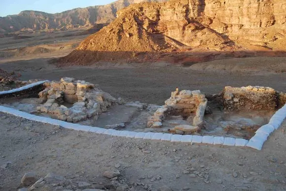
Because of Solomon’s excesses and sins, God punished him. New enemies appeared, and the tribes of Israel rejected Solomon and his successors. His kingdom split into two entities: the Kingdom of Israel to the north and the Kingdom of Judah to the south. Israel was ruled by Jeroboam, one of Solomon's former servants, while Solomon’s notoriously ineffectual son Rehoboam presided over Judah.
Both kingdoms suffered a devastating blow when an Egyptian pharaoh named Shoshenq removed all of Solomon’s wealth from his palace and the First Temple.
1 Kings 14:25–26 says:
In the fifth year of Rehoboam, Shishak, king of Egypt, attacked Jerusalem. He carried off the treasures of the Temple of the Lord and the treasures of the royal palace. He took everything, including all the gold shields Solomon had made.
Egyptians took it all
A temple pillar at Tell Basta, just north of Cairo, confirms the conquest. It states that Solomon's treasures were used as offerings to the Egyptian gods.
Throughout all these passages, there is no mention of Solomon's mines. But 1 Kings 7 explores the construction of the Temple and the materials he sourced. He cast two bronze pillars, 10 bronze carts, and four bronze wheels and axles. Solomon supposedly cast these objects "...in the plain of the Jordan, in the clay ground that lie between Succoth and Zarethan.”
This led historians and archaeologists to believe that Solomon might have used mining to sustain his wealth and maintain the Temple. So, perhaps the idea is not that far-fetched.
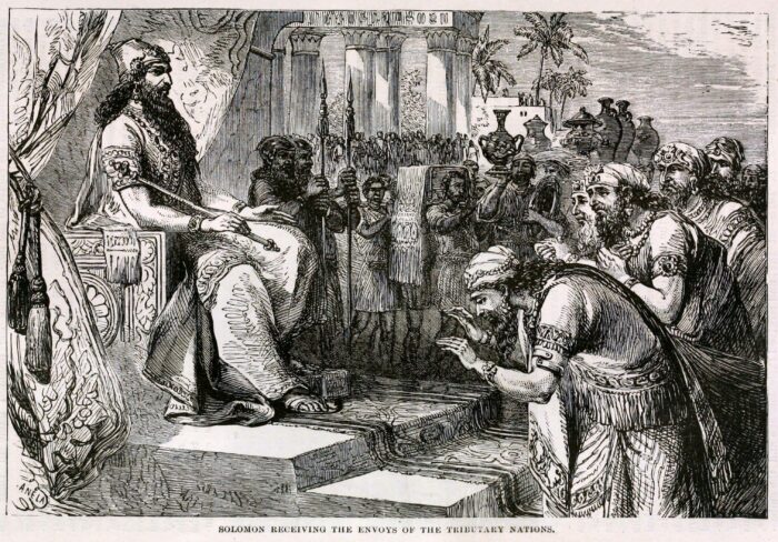
Archaeological evidence
James D. Muhly, a professor of Ancient Near East History at the University of Pennsylvania, states that there is “biblical silence” on the mines. However, numerous books on biblical archaeology do mention them, particularly Solomon’s focus on copper smelting. Solomon even bore the nickname, the Copper King.
The archaeological search for the mines began with the theories of Rabbi Nelson Glueck in 1934. He found large copper smelting slags in the Timna Valley, in the southern part of the Negev in modern-day Israel. Glueck also cited evidence of miners’ quarters.
A few years later, he excavated a mysterious mound in Tell-el Kheleifeh, between Israel’s southernmost city of Eilat and Aqaba in Jordan. This mound hid a large building complex which had a series of peculiar holes throughout the walls. Glueck believed that the building was a refinery and smelter, and the holes allowed wind to keep flames going.
He concluded that Tell-el Kheleifeh was the ancient port city of Ezion-Geber from the Bible. Here, Solomon sent ships to fetch treasures and metals.
The theory falls short
It did not take Glueck’s opponents long to poke holes in the theory. His main critic was a photographer and archaeologist named Beno Rothenberg. Rothenberg claimed that the holes in the walls were simply remnants of where beams were. Plus, mud plaster ringed the holes -- not the type of material that would survive smelting.
Rothenberg did his own investigations in the Timna Valley over the years. Though he found copper mines in the area, they dated before Solomon’s reign by a century and a half. They were also under Egyptian control, as confirmed by hieroglyphs in a temple at Hathor.
In 2013, archaeologists from Tel Aviv University excavated an area in the valley called Slave’s Hill. They found smelting camps containing pieces of clothing, food, broken pottery, and furnaces dating to Solomon’s time. However, they believe the camps belonged to the Edomites -- enemies of Solomon and Israel who lived in the Timna Valley at the same time.
Conclusion
Though the pieces seemed to go together well, the evidence suggests that King Solomon did not have copper mines, from which he cast his treasures, but likely sourced the materials elsewhere. If he did have mines, the Bible would have said so since it details all his other activities and sources of wealth. The legend of King Solomon’s Mines will likely remain a great work of adventure fiction. But this does not mean that other biblical treasures do not exist out there.
Talk to any archaeologist, and one of the first things they'll tell you is that the discipline has very little to do with bullwhips, leather jackets, or punching Nazis. But a team of scientists digging in Jordan has discovered one notable exception to the "real archaeology is not like an Indiana Jones movie" rule. They have unearthed an exceptional find buried beneath one of the film locations for Indiana Jones and the Last Crusade.
The scientists uncovered 12 human bodies entombed beneath a building known as The Treasury in the ancient city of Petra, Jordan. The 2,000-year-old remains date to sometime between the first century BC and the first century AD. The site also contained numerous artifacts.
If you've never heard of Petra, you'll probably still recognize it — the UNESCO World Heritage Site is half-built, half-carved out of the rose-colored sandstone cliffs located halfway between the Red Sea and the Dead Sea.

The Treasury, in particular, is iconic. It has graced the cover of National Geographic and was featured as the location of the Holy Grail in the third Indiana Jones movie. Today, it is a popular tourist attraction.
Suspicions confirmed
A few years ago, archaeologists discovered two tombs in The Treasury and suspected there might be more.
However, the funding and permits needed for investigations have been difficult to come by lately. So when a rare opportunity presented itself, a team led by Pearce Paul Creasman of the American Center of Research conducted ground-penetrating radar scans.
"That's when we discovered the signals which I interpreted as voids in the subsurface," Richard Bates, a professor of geophysics at the University of St. Andrews, told NPR.
The government of Jordan gave the go-ahead to begin digging. This past August, the team uncovered the 12 sets of remains in a chamber 5.5m long, 5.5m wide, and 3m deep. A film crew from the Discovery Channel was on hand when the bodies were discovered. An episode of Expedition Unknown aired on Wednesday, October 9, and chronicled the find. That's serendipitous because, astonishingly, the remains were unmolested by human hands — the bodies resting just as they were when originally entombed.
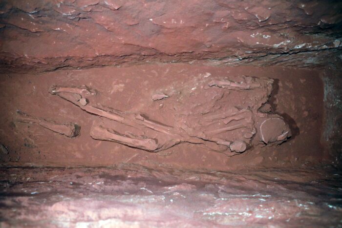
Petra was built by the Nabataeans. These desert nomads ruled a thriving kingdom in the area for 500 years until the Romans annexed it in 106 AD.
An improbable discovery
Creasman told CNN that it's extremely rare to find untouched human remains in Petra due to its location as a trading crossroads and travelers' millennia-old habit of ducking into the sandstone buildings to escape Jordan's oppressive heat.
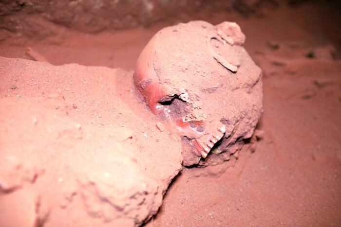
“We were hopeful of finding anything that might tell us more about the ancient people and place — human remains can be a really valuable tool in that regard,” Creasman said. “The burials in this tomb are articulated, so the bones haven’t been rummaged around and moved. That’s exceedingly rare.”
Intriguing artifact
The artifacts found with the remains are in even better condition. One of them, a ceramic cup, looks startlingly like the Holy Grail prop used in Indiana Jones and the Last Crusade. While the human remains are blessedly free of interference by human hands, several sets show signs of mold, likely owing to the porous sandstone Petra is carved from.
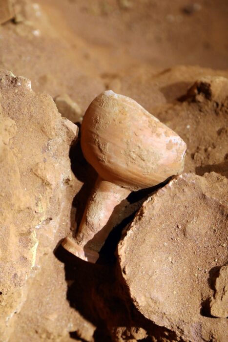
That means the team must proceed cautiously with the rest of the dig. As usual with archaeology, funding is an issue.
"The next step...is to get the money to properly exhume at least one of the bodies and do a full study on it," Bates said. "There are indications from the geophysics that there are other tombs there...A lot of where we go from here is going to be quite expensive, basically. So who knows when that's going to happen?"
Frozen in time, abandoned for 4,500 years, and under threat from an eroding coastline, Scotland’s "Pompeii" is the best-preserved Neolithic settlement in Western Europe. But despite Skara Brae's immaculate preservation, researchers still don't know why it was abandoned.
Storm reveals a forgotten village
Before its discovery, Skara Brae was nothing more than a sandy, grassy mound in the Orkney Islands off the coast of Scotland. In 1850, a powerful storm stripped the sand away, revealing bits of a small village.
One of the locals who stumbled upon the ruins was an amateur archaeologist named William Watt. Watt and his colleague, George Petrie, excavated the site and uncovered four houses. After Watt died in 1866, Petrie did not continue their work but did present his findings to the academic community.
The site was largely left alone until 1913 when, over a single weekend, someone plundered the site for artifacts. Soon after, another storm revealed more of the village.
In 1925, officials constructed a seawall to protect the ruins from the ocean. Then in 1927, researchers finally decided to investigate the site properly when the government granted access to archaeologist V. Gordon Childe from the University of Edinburgh.
Because of waterlogging and protection from the sand, the site was impressively well-preserved. The researchers found ten flagstone houses built deep into the ground. Each house has Stone Age furniture, including beds, a fireplace, and a Neolithic drainage system. Artifacts included animal bones, tools, jewelry, and pots, as well as a series of carved stone balls with rune-like symbols. Linguists have yet to crack what the runes mean.
Radiocarbon dating suggests most of the discoveries are from around 3180 BC. Around 2500 BC, village life died out. The village shows no sign of advancing further into the Bronze Age, and personal belongings were left behind.
What happened that caused the residents to abandon their homes?
Who lived there?
Archaeologists determined that less than 50 people lived in Skara Brae. The residents were most likely farmers and hunters. Researchers call them the "Grooved Ware People," after some of the distinctive objects they used. They left traces of their existence at other Neolithic sites in Orkney, including the Ring of Brodgar and the Standing Stones of Stenness.
So why did the small community leave? Some historians believe Skara Brae suffered a catastrophe akin to Pompeii. The area is prone to bad weather, and a particularly dreadful storm could have forced the residents to flee. The site was surrounded by dunes, so powerful winds could have blown sand into the village and buried the site.
Another theory is that natural erosion of the coastline threatened the village crops.
However, the site was most likely abandoned for several reasons. The transition from the Stone Age to the Bronze Age saw drastic social changes. The Bronze Age brought more sophisticated weaponry, more complex architecture, and the emergence of chiefdoms and hierarchies. Villages grew in size, and migration and trade increased. Perhaps the older residents of Skara Brae died off while the youngest moved on, looking for easier lives.
Skara Brae's abandonment was probably gradual. Straddling two time periods, it succumbed to the tides of change.
Still springing surprises
Recently, Dan Hicks of the University of Oxford tweeted several black-and-white photos from the 1929 Skara Brae excavation, setting off a group of "internet sleuths." The photos contained four women who people had long believed to be tourists. They were actually archaeologists. The internet sleuths embarked on a mission to uncover their identities.
Eventually, they found their names: Margaret Simpson, Margaret Mitchell, Dame Margaret Cole, and Mary Kennedy. All were students of Professor Childe’s. All but one became professional archaeologists. (Cole pursued a writing career.) The women were trailblazers, with female archaeologists exceedingly rare at the time.
The Permanent Court of Arbitration in the Hague will rule over who owns the world’s most valuable sunken ship.
In 1708, the British sank the San José off the coast of Colombia. The Spanish galleon still sits on the seabed over 700m down, beyond the reach of divers. Its billions of dollars worth of gold, silver, and emeralds make it the most valuable shipwreck on the planet. For obvious reasons, its precise location is not public.
The U.S. salvage company Glocca Mora found the San José in the 1980s. Since then, there has been a fierce debate over who owns the ship and whether it should be raised from its watery grave. Colombia, Spain, indigenous communities in South America, and Glocca Mora -- now known as Sea Search Armada -- all claim it belongs to them.
After several inconclusive cases, the court in the Hague will decide once and for all who owns it. Colombia claims that as the boat sank off its coast, it should be theirs. They want to raise it and put it on display.
When Glocca Mora found the ship, they wanted to share the fortune -- and the task of raising it -- with Colombia. But the two sides could not agree on who got what percentage, and the battle has raged since then.
In 2015, the Colombian government claimed that they had discovered the ship in a different location than the salvage company claimed. Since then, Colombia has insisted that the salvagers have no rights to the boat or its treasure.
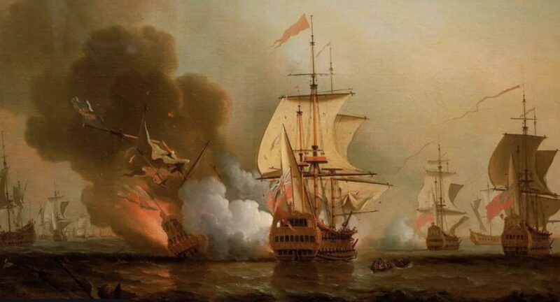
What about Spain?
Meanwhile, Spain argues that since it is their ship, it is Spanish property. Indigenous communities in South America believe they should profit from the treasure, as it was pillaged from them during colonial times.
“That wealth came from the mines of Potosí in the Bolivian highlands," said a spokesperson for the groups. "This cargo belongs to our people...They owe us that debt.”
Historians, archaeologists, and preservation groups argue that the vessel should be left alone. Over 600 people died when it sank, meaning that the wreckage is also a graveyard. Out of respect, many feel that it should be left as is.
The British never intended to sink the ship. At the time, a war raged between Spain and Britain. As a British ship tried to seize the San José and its treasure off the coast of Colombia, it fired a cannonball, which happened to land on the San José's gunpowder store. Within minutes, the ship and all its treasures sank.
The treasure's value also remains in dispute. As part of its case, Sea Search Armada estimated it is worth $7-$18 billion, but historians say such an estimate is impossible.
"If you’re talking about gold and silver coins, do we make an estimate based on the weight of the gold now? Or do we look at what collectors might pay for these gold coins?"
International law does very little to clear up the ownership argument, so for now, the decision rests with the Hague. But there are no details on when this legal wrangle will end.
Another piece of the Franklin Expedition puzzle has dropped into place. However, like most new bits of information concerning this enduring exploration mystery, it raises more questions than it answers.
Using samples from a living descendant of an expedition member, researchers from the University of Waterloo and Lakehead University struck upon a DNA match with a mandible found on King William Island, Nunavut. The remains of at least 13 expedition members have been recovered in the area.
“We worked with a good quality sample that allowed us to generate a Y-chromosome profile. We were lucky enough to obtain a match,” Stephen Fratpietro, of Lakehead University's Paleo-DNA lab, said.
The mandible is from James Fitzjames. Fitzjames stepped in to captain one of the ships after Sir John Franklin, the expedition's leader, died on June 11, 1847.
Fitzjames' mandible is one of four sets of remains from the site that show evidence of cannibalism.
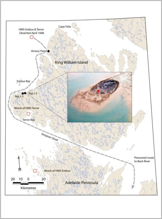
“This shows that he predeceased at least some of the other sailors who perished and that neither rank nor status was the governing principle in the final desperate days of the expedition as they strove to save themselves,” Douglas Stenton, adjunct professor of anthropology at the University of Waterloo, explained.
"Identifying Fitzjames’ remains provides new insights about the expedition's sad ending," he continued.
The team published its findings in the Journal of Archaeological Science: Reports.
A doomed expedition
The expedition, helmed by seasoned polar explorer John Franklin, set out from Britain in May 1845. Franklin aimed to find the Northwest Passage, a navigable waterway linking the Atlantic and Pacific oceans. Two ships, the HMS Erebus and the HMS Terror, held 129 men.
After two years with no word, the first of 39 rescue missions was dispatched. Yet Europeans never saw any of the 129 men alive again.
In the subsequent decades, searchers, researchers, and archaeologists have continued to uncover relics, bones, and other evidence of the expedition. A key discovery was the so-called Victory Point Note. Scribbled in the margins of a standard Admiralty form, the note is dated May 28, 1847. It indicates that the men abandoned the Erebus and Terror after the ships became trapped by crushing ice. After leaving the ships, the crew's goal was to hike south toward the Canadian mainland.
"Sir John Franklin died on June 11, 1847, and the total loss by deaths in the expedition has been to this date nine officers and 15 men…[We] start on tomorrow 26th for Backs Fish River," the message reads in part. Fitzjames and Franklin's second-in-command, Captain Francis Crozier, signed the dispatch.
Human remains from the expedition dot the western and northern coasts of King William Island. Fitzjames' mandible was recovered from a site known as NgLj-2.
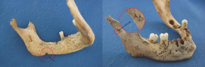
Utilizing traditional knowledge passed on by the area's Inuit inhabitants, researchers discovered the sunken wrecks of the Erebus in 2014 and the Terror in 2016. Underwater excavations of these sites are ongoing.
Armchair sleuthing
Remembering the Franklin Expedition is a Facebook group roughly 4,000 members strong. The group's participants range from casual fans drawn by the expedition's recent portrayals in works of fiction to scientists with decades of Franklin research under their belts. ExplorersWeb previously interviewed Randall Osczevski, a retired Arctic scientist who now spends his days peering at publically available satellite imagery, hoping to find clues behind the lost expeditions' final days.
And it was another of the group's members, Fabienne Tetteroo, who helped track down a possible Fitzjames descendant for a DNA match. Tetteroo connected that person with the DNA researchers.
Tetteroo had been conducting independent research on Fitzjames for two years before starting to write a book on him. The book will form part of her master's degree in Naval History from the University of Portsmouth, England. During her research, she discovered that Stenton and his team were struggling to find any of Fitzjames' descendants to test for a DNA match.
"The possibility that someone had found Fitzjames' remains but that this could not be tested was enticing. Through genealogical research, consulting a handwritten family tree, and online birth records, I found an eligible candidate for a match with Fitzjames," Tetteroo told ExplorersWeb. "Thankfully, this person was happy to participate. I've been dreaming of the day that someone would find Fitzjames, and now this dream has come true."
The timing couldn't be better — Tetteroo turned in her thesis last Friday.
A community mourns and celebrates
To a group of people who obsess over the discovery of every button, nail, and scrap of leather, the news is cause for both celebration and somber reflection.
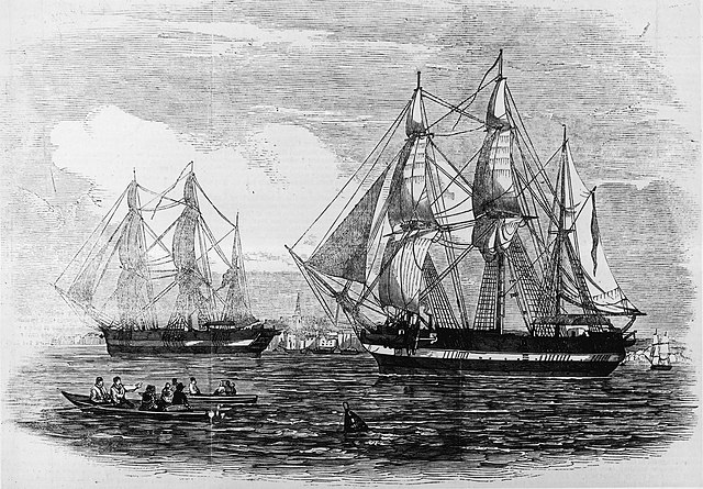
William Battersby was an institutional marketer who left that career to become a prolific Arctic historian and author of a book on Fitzjames. He passed away in 2016, but his daughter, Maddie Battersby, is a member of the Franklin Facebook group.
"[I feel] relief, disbelief, and grief; for Fitzjames, for the many families with loved ones in the expedition who died not knowing what happened to their loved ones, and for me. I grieve for my dad, who died eight years ago, and so hasn’t lived to see this development," she said.
"I just wish I could go back in time and tell him that in the future, when he’s found, thousands of strangers will cry for him. Out of sadness...because no one deserves to die like this, but also out of relief," another group member, Hannah Tackett, noted. "Thousands of people not only remember his name 176 years in the future but celebrate when he’s found again. An entire community built around this expedition...will love and grieve together."
Helping the cause
The scientists responsible for the DNA match are excited about further research but could use a little help from the general public.
“We are extremely grateful to this family for sharing their history with us and for providing DNA samples. We welcome opportunities to work with other descendants of members of the Franklin expedition to see if their DNA can be used to identify other individuals," Stenton said.
As archaeological technology improves, more puzzle pieces will fall into place. Whether those pieces will eventually assemble into a complete image is debatable.
But in the spirit of exploration against long odds, that doesn't stop a diverse group of people from across the globe — scientists and amateur Arctic detectives alike — from trying.
As the Chinese proverb goes, "When the winds of change blow, some build walls, others build windmills." In the case of several remote villages in Iran and Afghanistan, this could not be more true. For centuries, these villages have suffered harsh wind storms that sweep down the plains.
Their answer? Odd-looking structures made from clay and wood. They may not look like much, but they house ingenious mechanical designs. These are the world’s oldest windmills, called "asbads."
Though asbads have slowly been replaced by more advanced designs, some locals strive to maintain them. They are one of the world's first renewable energy prototypes.
The creator of the first windmill
Abu Lu’lu’a Firuz was a Persian slave who lived in the mid-seventh century AD. He was a non-Muslim and may have originally been a Zoroastrian priest.
Non-Muslims were banned from entering and living in the region's Rashidun Caliphate, the empire that immediately succeeded the prophet Muhammad. But because of his exceptional engineering skills, Firuz was allowed access to the capital in Medina alongside his master.
Firuz specialized in machines that could harness the wind and attract the caliph's attention. According to the History of al-Tabari, a chronicle written in 915AD, the caliph Umar ibn al-Khattab said, "I heard you make windmills. Make one for me as well."
"By God, I will build this windmill of which the world will talk," Firuz replied.
This seemed like a good set-up for political favor but it did not turn out that way. Umar established a harsh tax which Firuz refused to pay. Firuz then assassinated Umar while the caliph was leading prayers in a mosque. We are not sure what happened to Firuz after.
However, we know that his invention stood the test of time and still functions today. He created a type of windmill referred to as a panemone. This is a windmill with a vertical axis. Only a handful of them still stand.
Harnessing the wind
After taking the Muslim world by storm, windmills made their way to other parts of Asia and Europe in the 12th century. After invading Iran, the Mongols found them so impressive that they sought to kidnap windmill engineers.
Windmills started popping up in China, Africa, and Europe. Inventors modified them into different shapes, sizes, and designs. But it was only centuries later in Northern and Western Europe that windmills started to take on a horizontal axis. Eventually, horizontal-axis windmills became the most widely used design (as they are today).
A panemone windmill possesses a rotating axis positioned at 90° in the direction of the wind, while the wind-catching blades move parallel to the wind. It is a drag-type turbine. Drag refers to an aerodynamic force that acts opposite to an object's motion through the air. Drag results in less energy and poor efficiency. In Iran and Afghanistan, the panemone windmill is encased in something called an 'asbad'.

An asbad is a two-story adobe, mud, or clay structure. They are typically 20m tall and situated on a hill overlooking a village. The ground floor held millstones to grind grain or machinery to pump water. The top story had a long wall with chambers, each chamber contained six or eight wooden sails dressed with cloth or straw on a vertical axle.
The asbad takes the brunt of strong winds, converting them into useful kinetic energy. As the wind blows through the chambers, it rotates the wheels and vanes to kickstart the grinding or pumping processes below. Harnessing the wind could process a bag of over 100kg of wheat.

The ancient Persians utilized these windmills for two main reasons: to grind wheat and pump water. For the time, asbads were revolutionary and made life much easier. According to historian Robert Forbes, asbads could also chop sugarcane and other crops.
Fighting 120-day winds
The best place to find well-preserved asbads is in the village of Nashtifan in northeastern Iran. Of the 30 windmills there, five are in working order. There are also a few standing in Sistan to the south.
Since the days of the caliphate, the asbads have helped combat the region’s infamous 120-day 'Sistan Winds'. These wind storms occur from May to September and make life difficult for the villagers. They cause intense droughts and can blow at up to 100kmph. In 1991 these winds carried so much dust along the Iran-Afghanistan border that it dried up Lake Hamun. As a result, nearby villages were abandoned and people had to migrate elsewhere.

The Sistan Winds result from the interaction between seasonal winds and the landscape. Their intensity gave rise to the village's name, which translates as "storm's sting."
Heritage
While they seem obsolete compared to modern technology, the asbads play a vital role in the lives of Nashtifan villagers. They draw tourists and are a key part of the villagers' cultural heritage.
In 2002, the Iranian Government recognized the windmills as part of the country's heritage. Unfortunately, maintenance is quite difficult. In Nashtifan, Mohammed Etebari is on a mission to preserve these ancient prototypes. He meticulously cares and cleans them every day. Let's hope that someone steps up to look after these historical treasures when he is gone.
While horizontal-axis windmills are still the norm, some see the benefits of vertical-axis turbines. William Walker of Stress Engineering Services believes that vertical windmills are easier to maintain, would work better for farms, can withstand very high winds, and can reduce production costs. They cause less harm to the environment, less noise pollution, and can generate enough electricity for small-scale operations.
So, could these ancient windmills compete with modern wind turbines? According to National Geographic, an asbad could not even power a lightbulb. Whether useful for generating energy or not, it would be a great shame to let these historic windmills disappear forever.
Archaeologists have long known that humans and Neanderthals interbred, but where this took place has been hard to pinpoint. A new study may have solved the mystery.
More than just co-existence
Neanderthals and ancient humans co-existed for tens of thousands of years. It is no great surprise that they came into contact with each other. But in 2010, it became clear that they had done far more than simply cross paths. Researchers sequenced the Neanderthal genome for the first time, and it was apparent that some inter-species canoodling had occurred.
We know that interbreeding took place during the Late Pleistocene era. Using ecological niche modeling, researchers mapped the distribution of both groups in Southwest Asia and Southeast Europe during this period. They wanted to see where the two species overlapped.
This identified a potential meeting point, the Zagros Mountains, which stretch across modern-day Iran, Iraq, and Turkey. Researchers believe that the mountains acted as a corridor between the Palearctic region that played host to Neanderthals, and the Afrotropical region that our ancestors came from.
Harsh climate may have forced interaction
The topography of the mountains and its diverse life meant that the area could support quite a large human population. The harsh climate of the time may have pushed both groups into small pockets in the region.
"The border areas of two realms...operate as refuges for species from glacial environments," the team commented.
More importantly, the area aligns almost perfectly with the small amount of archaeological evidence we have. Remains from both groups occur throughout the mountains. The most famous of these sites, the Shanidar Cave in northern Iraq, has the best-preserved Neanderthal ever discovered.
Other studies found similarities between the facial features of Neanderthals and modern humans in the region, further supporting the hypothesis.
While ancient humans migrated out of Africa and traveled north across the mountain corridor, scientists know that Neanderthals were living on the Persian plateau. The research team has a single tooth and several tools that place them there.
This all ties in with the second wave of interbreeding that we know happened between 80 and 120 thousand years ago. The hook-up is still visible in our genetics.
Lying at the bottom of the cold North Atlantic, the Titanic has changed dramatically in the 112 years since it sank. New photos of the wreck show just how much the old ship has decayed in recent years.
RMS Titanic Inc. has owned the salvage rights of the wreck since the 1980s. During that period, they visited the site nine times. Recently, two remotely operated vehicles captured 24 hours of footage and over two million images of the site. The main aim was to pinpoint any artifacts at risk.

The ship's bow railing, familiar to every movie-goer as the spot where Jack taught Rose to fly, has largely fallen away in the last two years. It now lies on the ocean floor next to the ship.
At the same time, stalactites of rust are forming all over the ship, which is rapidly breaking down. No one knows how long it will last.
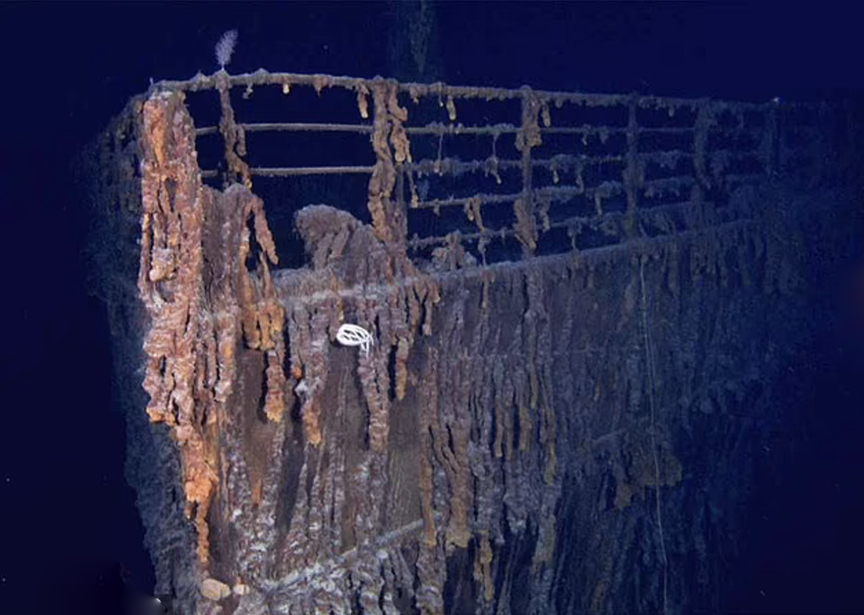
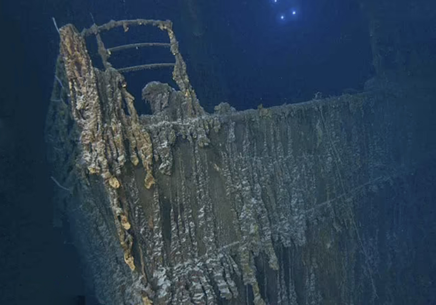
“We are saddened by this loss and the inevitable decay of the ship,” the company said in a statement. Over the next few weeks and months, we will conduct a more thorough review of Titanic’s condition and her changes over time...This evidence strengthens our mission to preserve and document what we can before it is too late.”
The steady decline of the wreck has been visible in the last few expeditions. In 2019, Victor Vescovo’s expedition to the wreck showed the officers' quarters on the starboard side had collapsed into the staterooms.
Exciting discovery
One exciting discovery of the recent expedition that is not about the deterioration shows a bronze statue of Diana. The 60cm-tall statue of the Roman goddess originally adorned the mantle of the fireplace in the First Class lounge.
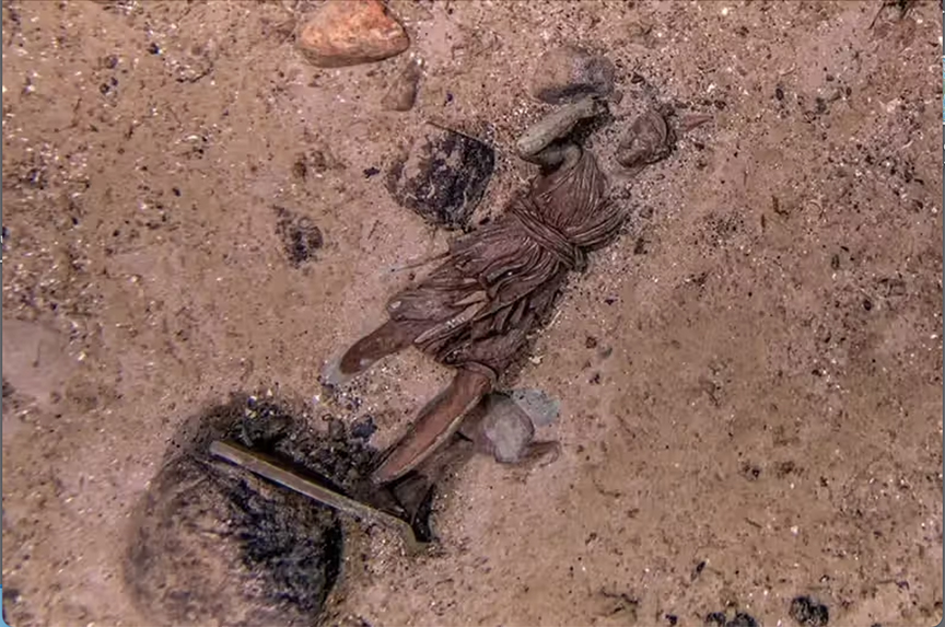
"The first-class lounge was the most beautiful, and unbelievably detailed, room on the ship,” said researcher James Penca. "And the centerpiece of that room was the Diana of Versailles."
The room was torn apart when the ship sank, and the statue landed in the debris field. It had been photographed before, in 1986, but its exact location was unknown, so its rediscovery was exciting. It is rare to find any artwork on the shipwreck. Most of the art broke down relatively quickly after the ship sank.
The team plans to return to the site next year and recover the Diana statue and a number of other artifacts.
"To bring Diana back so people can see her with their own eyes -- the value in that, to spark a love of history, of diving, of conservation, of shipwrecks, of sculpture...I could never leave that on the ocean floor,” says Penca.
It has long been thought that the Vikings in Scandinavian countries were equally aggressive. That was not the case. A new study suggests that the Norwegians were the fiercest and most lawless Vikings of all.
Remains excavated from ancient graveyards in Norway show far more skeletal trauma than those from Denmark. While 33% of the Norwegian skeletons showed past injuries and 37% showed signs of violent death, only 6% of those in Denmark died violently, nearly all by execution.
Researchers also found far more weapons among Norwegian remains. In Norway, they uncovered over 3,000 swords dating to the Viking and Late Iron Age eras. In Danish cemeteries, they found just a few dozen. The authors of the study believe this shows weaponry played a far greater role in Norwegian Viking society.
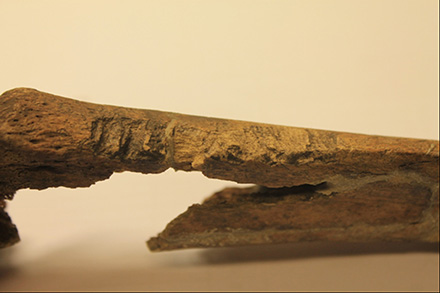
The team combined the study of the remains and weaponry with that of runestones –- the ancient Scandinavians' attempt at record-keeping.
The Danish communities showed far more social structure and authoritative figures. Their violence was relatively controlled. The deaths by execution imply that violence was meted out as punishment, whereas the high levels of injury in Norway suggest that it was interpersonal.
Danish Vikings also had large fortifications, which suggests large work forces, coordinated efforts, and an organized society. Their punishments and levels of aggression reflect this.
Norway was more lawless
In stark contrast, the Norwegians' world was more decentralized and rife with lawlessness. Ultimately, personal grievances led to personal violence. Gender played no role in how barbaric an attack was. Norwegian women and men both had similar amounts of trauma.
“The use of violence does not appear to have been reserved for Norwegian men, hinting at a level of gender equality in terms of social status," explained the authors.
"These patterns suggest that we are talking of distinct societies in the regions of Norway and Denmark,” added lead author David Jacobson.
The findings not only add to the idea that Viking communities had significantly different cultures but that societies with stricter authorities and hierarchy had lower levels of violence. This was also the case in parts of North and South America.
Four recently translated Babylonian tablets give insight into the supernatural concerns of that ancient era. The 4,000-year-old clay tablets hold 61 ominous warnings of the death, doom, and destruction that will surely follow lunar eclipses. Most of them were terrible news for the king at the time.
Andrew George and Junko Taniguchi have been translating the tablets with the help of artificial intelligence. The tablets were unearthed over a century ago in present-day Iraq and have been in the British Museum since then. They were created in the ancient city of Sippar between the 17th and 18th centuries BC. They are the oldest inventory of lunar eclipse omens ever discovered.
Among the dire predictions: a lunar eclipse in the morning “means the end of dynasty.” One in the evening “signifies pestilence.” If an eclipse begins in the south, it predicts the “downfall of Subartu and Akkad” (other regions at the time).
Mad dogs and locusts
Others warn that “rain will be cut off from the sky,” “there will be an attack on land by a locust swarm,” and “a dog will go mad, and nobody bitten by it will survive.”
Babylonia was part of Mesopotamia, and astrology played a large role in its culture. The king's closest advisors watched the night sky, matching their observations with those of celestial-omen texts.
If negative predictions threatened the monarch, his advisors killed animals and used their entrails to decipher the omen. Rituals then took place to protect against it.
For some particularly nasty omens about the king, a substitute king would be named. He would then become the target of divine wrath, sparing the actual king from harm.
“Astrological observation was part of an elaborate method of protecting the king and regulating his behavior [to conform to] the wishes of the gods,” the authors explain in the new study.
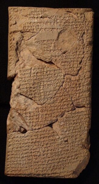
Making sense of a lunar eclipse
The translated tablets show how important these omens were to the Babylonians. They are essentially a set of instructions for making sense of a lunar eclipse. Every aspect of the eclipse held meaning. The time of day, the date, the month, the movement of shadows, and the duration all signified different omens. Any lunar event was thought to be a warning from the gods.
The study suggests that most omens conformed to people's experiences. They would connect bad things that had happened to what they saw happening in the world, or more specifically, the sky.
“Babylonian astrology was an academic branch of divination founded on the belief that events in the sky were coded signs placed there by the gods as warnings about the future prospects of those on Earth,” explained the authors.
Archaeologists have uncovered the bones of the ninth-century bishop who helped to create the Camino de Santiago. This makes him the oldest identified historical figure in Spain.
The remains were initially found in 1955 in a tomb in northwestern Spain. Multiple studies on the bones have thrown up hugely contradictory findings. The first concluded they belonged to an elderly male. Decades later, another study claimed they belonged to a woman over the age of 50. New analysis is much more specific. It suggests they belong to Bishop Teodomiro of Iria Flavia.
According to legend, Teodomiro discovered the tomb of St. James the Apostle in Santiago de Compostela. A hermit told him about a shower of bright stars; when Teodomiro went to investigate, he found the tomb. After St. James died in Jerusalem, two of his disciples purportedly took his remains to northwestern Spain.

Origin of the Camino de Santiago
When King Alfonso II heard of the discovery, he and his court marched from Oviedo to Santiago. In doing so, they created a 146km pilgrimage route that many still walk today. The Camino de Santiago is an extensive network of ancient pilgrim trails that stretch across Europe. All end at the tomb of St. James. King Alfonso II's route is known as the Primitive Way.
“After St. James the Apostle, Bishop Teodomiro of Iria Flavia is the most important figure associated with the pilgrimage to Santiago de Compostela," wrote the researchers. "He supposedly discovered the [Apostle's] tomb after a divine revelation between 820 and 830 AD.”
The new analysis combined various methods to decipher who the bones belonged to. Carbon dating, isotope analysis, bone analysis, and DNA testing all point toward a male who died after the age of 45, had a weak build, and led a fairly sedentary lifestyle.
This might sound like thin evidence on which to attribute the remains to a specific person. However, when analyzed together, a picture starts to form. Until 1955, scholars debated whether a real Teodomiro even existed. Then the tomb containing the remains was discovered. The inscription on it read, "In this tomb rests the servant of God Teodomiro, Bishop of the See of Iria."
Various studies on the remains then confused matters.
All clues point to the bishop
Now, radiocarbon dating proves the man within the tomb died around the same time as Teodomiro. Genetic analysis suggests that the person was related to the Roman, Visigoth, and Islamic populations of the Iberian Peninsula. The authors of the new study claim that this is “consistent with someone living in Spain 1,200 years ago”.
Lastly, the bone analysis points to a man who was relatively weak and not very physically active. Members of the clergy would have done very little manual labor in the ninth century, so all of this rings true.
Though no one will ever be able to prove that these remains belong to Teodomiro, the authors believe that there is a “98% probability” that they do.
Despite what proponents of pseudo-archaeology would have you believe, the past is interesting enough without bringing aliens into it.
For instance, there are plenty of history-altering, world-shaking figures whose burial places are unknown. And we're not talking about quasi-mythological figures from the Bronze Age like Agamemnon or Odysseus. Proven historical figures like Alexander the Great, Genghis Khan, and Cleopatra are all resting in places unknown.
In some cases, these lost tombs result from cultural practices. Other times, the mystery springs from secrecy, betrayal, intrigue, or a combination of all three.
The quest to find the bodies of these figures is as fascinating as the history of how they came to be lost in the first place. What spectacular funerary goods lay in Cleopatra's tomb? What could we learn from Genghis Khan's DNA? And what insights might a hypothetical set of Alexander the Great's journals hold?
So plop on your pith helmet and settle in. Lost tombs await.
Alexander the Great
There's a reason they call him "The Great." Alexander of Macedon was one of the most audacious, skilled, and well-traveled humans the world has ever known. By the time Alexander was 20, his father, Phillip II, had accomplished what no one else had ever managed — uniting the eternally battling city-states of Greece under military rule.
Phillip II didn't stop there. Bolstered by deadly Greek hoplites (heavy infantry), the Macedonian army was moments away from invading the deadly Persian Empire when he was assassinated.
Alexander inherited his father's army and promptly took up where his father left off, eventually doing what no one in the classical world thought possible — toppling the Persian Empire. Alexander then continued toward the edge of the map, eventually turning around on the Indian subcontinent after his exhausted troops threatened to mutiny. Along the way, he spread Hellenistic (Greek-like) culture across the Near East and Central Asia, an act historians agree altered the course of human history.
Alexander returned to Babylon to rule his new empire. But it wasn't to be. Shortly before his death, someone asked him who should inherit the empire. His answer, famously, was "the strongest."
Doomed empire
It was a sentiment typical of the brusque young warrior, but it ultimately doomed his hard-won empire. His closest generals almost immediately fell into civil war, eventually dividing up the spoils among themselves. Ptolemy, perhaps the most gifted of them, ended up in Egypt, making his seat in the Alexander-founded city of Alexandria.
Meanwhile, a caravan containing Alexander's body was on its way back to Macedon. In a move seemingly custom-designed to irritate his former comrades, Ptolemy had it snatched and brought to Egypt.
The corpse, initially enclosed in a form-fitting coffin of hammered gold, eventually wound up on display in Alexandria. Over the centuries, luminaries from antiquity, like Julius Caesar, Augustus, and Cleopatra (more on her later), made pilgrimages to honor Alexander's legacy and ponder their own. By the time Caesar saw it, Alexander's body was resting in a spectacular coffin with a see-through crystal top.
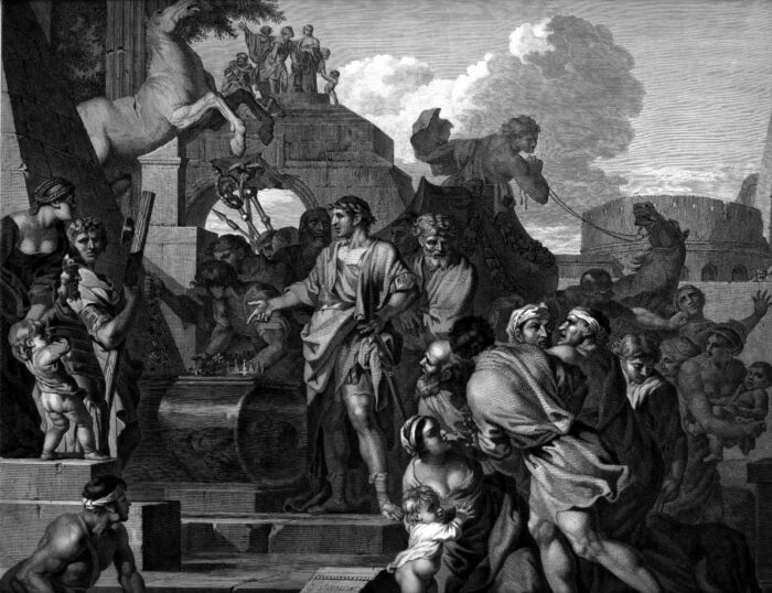
It's unclear when or how the tomb was eventually lost. In the centuries between the rise and decline of the Roman Empire, various historical figures looted the tomb for gold or relics. So it's possible a well-meaning leader secreted away the body to stop the practice. In any case, when the early Christian John Chrysostom visited Alexandria in 400 AD, no one remembered where Alexander the Great lay buried.
Excitement and disappointment
Given how often we know Alexander's body changed hands, moved, or was looted over the centuries, it's unlikely that the tomb, wherever it is, contains the wonderous treasures that delight museumgoers. But it doesn't matter. Archaeologists have been searching for it since before archaeology was an official branch of academia.
And so the hunt was on. The Egyptian Supreme Council for Antiquities cataloged over 140 official attempts to find the body, and there have doubtless been many under-the-radar quests as well.
Initial 19th-century consensus placed the tomb somewhere within Alexandria. The problem is that Alexandria has been continuously occupied since its founding in 331 BC.. It has thus endured all the earthquakes, fires, civil unrest, sackings, and religious changes you'd expect.
Alexander's tomb might have been paved over or buried during an earthquake. It might be under a Christian church or a mosque, and the people who run each aren't generally too happy to see workers with shovels and pick-axes showing up on the doorstep.
Enter Heinrich Schliemann
Everyone's favorite bumbling-yet-brilliant early archaeologist, Heinrich Schliemann, had a pet theory and petitioned a mosque to excavate but was denied. Given the lasting damage Schliemann did to Troy — and his tendency to assume whatever he stumbled upon was what he was looking for — that's probably a good thing.
In more modern times, archaeologists have expanded their search beyond the borders of Alexander's most famous city. Some Greek archaeologists have proposed that Alexander's body, not his father Phillip II's, is buried in Macedon.
Others claim that relics found in the Siwa Oasis — an important location in Egyptian spirituality and Alexander's conquest of Egypt — hold his remains. As recently as 2021, Egyptian officials claimed to have found evidence of Alexander's tomb there, though the tomb itself never materialized.
One National Geographic television host claimed that the body was stolen by merchants and taken to Venice, where it is now venerated as the body of Saint Mark the Evangelist. This possibility seems the least likely, though given the remains' long history of being snatched and used for personal gain, who can say?
And so the hunt for the body of Alexander the Great continues.
Genghis Khan requests a humble burial
We'll return to Egypt, that land of oh-so-many lost tombs, in a moment. But first, a brief side trip across Asia to examine one of history's other great lost conquerors, Genghis Khan.
Dubbed Temujin after his birth on the Asian steppes between 1155 and 1167 AD, the fierce warrior consolidated his fractious people and set to work. Horse archers are some of history's most implacable battlefield opponents, and the Mongols, under Genghis Khan and his descendants, eventually created an empire that stretched from China to Eastern Europe. The utter devastation the Mongols wrecked on the powerful Islamic empire, in particular, allowed Christian Europeans to get a toehold in the Holy Lands — another historic inflection point that still has powerful ramifications in modern geopolitics.
When he died in August 1227, he was buried in a spot he'd chosen earlier, on or near a mountain called Burkhan Khaldun, close to his birthplace. However, Genghis Khan's successors immediately kept the funeral details secret, probably to prevent rival court factions from interfering with the body.
On top of that, Genghis Khan reportedly requested no grave marker at his burial place. Only a small honor guard knew the exact location of the body, and the mountain and surrounding regions were promptly declared taboo.
A sacred mountain
As with the corpse of Alexander the Great, time and political upheaval took their toll. The Mongol Empire eventually fractured and decayed, and those who knew the burial location died without passing on their secrets. Folklore developed over the centuries holds that a river was diverted over the burial place to further hide it, or that trees were planted over it.
Due to the political unrest in Asia over the last century or so, serious searches for Genghis Khan's tomb didn't really ramp up until the last twenty years or so. Most of the questing has been done remotely and non-invasively with satellites or drones.
For instance, in 2015, Dr. Albert Yu-Min Lin used publicly available satellite imagery and crowd-sourcing to identify 55 possible burial sites. He published his findings in the journal Public Library of Science One, but the sites have yet to be excavated.
Archaeologist Pierre-Henri Giscard and scientific image specialist Raphael Hautefort unearthed another promising lead at around the same time. The two men led a team that used drones to image the top of Burkhan Khaldun and uncovered a tumulus — a heap of earth and stone piled over a burial site. The scientists claim that the 250m-long mound is of human origin and modeled after contemporaneous imperial Chinese burial mounds.
Unfortunately, Giscard and Hautefort conducted their expedition without permits — they didn't even let local authorities know they were in the area. Genghis Khan is, quite understandably, a figure of some national pride for Mongolians, and Burkhan Khaldun is still considered sacred by local populations. To date, the tumulus is still unexplored — just like Genghis Khan would have wanted.
Things end badly for Cleopatra
Cleopatra is often relegated to a footnote in the story of Rome's troubled transition from a republican to an authoritarian government — or dismissed as a classical sex symbol who slept her way into power. But she deserves better from history.
By all accounts brilliant, she was a skilled linguist who was the first member of the Greek-speaking Ptolemaic dynasty to learn Egyptian. She was also a masterful politician. With a little help from Rome, she successfully fended off a coup attempt by her younger brother. In short, she was shaping up to be one of the most capable leaders Egypt had seen in years.
However, the Roman civil war eventually spelled the end for both Egyptian autonomy and Cleopatra herself. In the wake of Caesar's assassination, rival factions coalesced around Octavian (later Augustus) and Mark Antony for control of Rome. Choosing between humiliating client-state treatment at the hands of Octavian and possible joint rule with her lover Antony, Cleopatra made an understandable, if fateful, choice.
Her last-ditch naval effort at the Battle of Actium ended in defeat for Cleopatra and Antony. The two retreated with what was left of their army to mainland Egypt to await invasion by Octavian's forces. As the wolves closed in, the two elected to kill themselves rather than fall into the invader's hands.
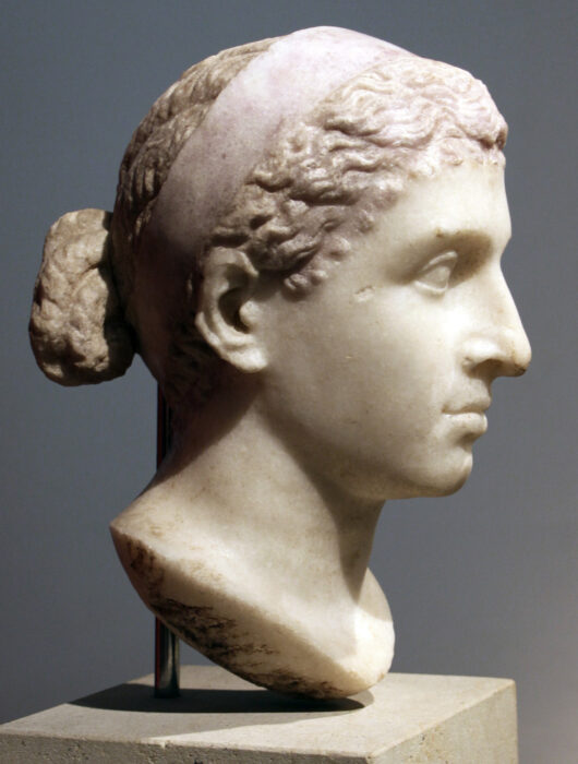
Buried together
Octavian, displaying the political tact that would soon mark him as among the most skilled of Rome's mixed bag of Emperors, allowed the two to be buried together without defiling their corpses. (It should be noted that the Roman historian Plutarch claims Antony was cremated, but sources are mixed.)
But Octavian was also nothing if not pragmatic. As an Egyptian leader from the powerful and wealthy Ptolemaic dynasty, Cleopatra's tomb was completed long before her death, and many people knew where it was at first. Octavian certainly did — he made sure to loot it of the vast treasures Cleopatra had stashed away there.
According to Roman sources, he used the gold, silks, and jewels to pay off debts, to further consolidate his power, and to bribe his troops into not sacking Alexandria. The circumstances do raise an intriguing historical question — what would the months following Octavian's final rise to power have been like without that crucial influx of wealth at just the right moment?
Egyptologists disagree
The lost tomb of Antony and Cleopatra shares much with Alexander's tomb — namely, proximity to the bustling city of Alexandria and nearly two thousand years of human history to sort through. All the difficulties of finding Alexander's tomb also apply to Cleopatra's, with the added difficulty that Cleopatra's life story didn't inspire the same kind of feverish dedication in 19th-century archaeologists that Alexander's did.
Still, modern research is promising. Egyptologist Kathleen Martinez has been hard at work on the search since 2005. She is focusing on the Taposiris Magna, a temple to Osiris lying west of Alexandria. Using traditional archaeological techniques as well as ground-penetrating radar, Martinez and her team have uncovered ten mummies from 27 tombs in the area, as well as promising coins and carvings bearing Cleopatra's image.
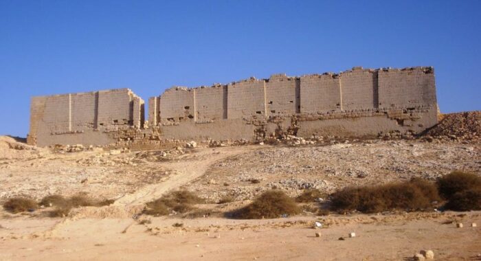
In November 2022, Martinez discovered a 1,300m tunnel under Taposiris Magna, which she believes might lead to the tomb. Excavations are ongoing.
Another prominent Egyptologist, Zahi Hawass, disagrees. At an archaeological conference, Hawass stated that Cleopatra was unlikely to be buried near a temple, as Egyptian temples were for worship, not burial.
The legacy of death
Regardless of this scholarly disagreement, of the three lost tombs mentioned here, that of Cleopatra seems the most likely to be discovered in our lifetime. All we non-archaeologists can do is watch the news.
In any case, if the millennia-long search for certain lost tombs tells us anything, it's that for those who swing the pendulum of human history, the end is often only the beginning.
A new study has revealed that Stonehenge's six-tonne altar stone came from even further afield than archaeologists thought. Neolithic people somehow moved the enormous stone roughly 750km from northeastern Scotland to southwestern England.
A new mystery
The altar stone lies at the heart of Stonehenge, buried in the center of the circle. Much like the Neolithic site it belongs to, its purpose remains a mystery.
The majority of the Stonehenge Circle is made of either sarsen (silicified sandstone blocks) or bluestone (a type of fine-grained sandstone). The sarsen stones are from the nearby West Woods. But the bluestones come from the Preseli Hills in southwest Wales, already a monumental distance to transport heavy loads with primitive technology.
The sandstone altar stone is the biggest bluestone, and researchers had assumed it came from the same corner of Wales. Fresh geological fingerprinting shows that this is not the case.
The altar stone was added to the site during the second construction phase between 2620 and 2480 BC. Last year, Nick Pearce, a professor of geography and earth sciences at Aberystwyth University, declared that the stone was not from Wales. Now, an international team from Wales, Australia, and England has pinpointed its original location in northern Scotland.
“I don’t think I’ll be forgiven by people back home," lead author Anthony Clarke, who is from Wales, told the BBC.
A shocking result
Stonehenge is a World Heritage Site, and researchers cannot chip away at the stones. Instead, they have to use historical samples. One of the study's samples was taken in the 1840s, the other in the 1920s. The team studied the mineral grains in the stone fragments to analyze their age. The chemical fingerprint showed that some minerals are two billion years old, while others are around 450 million years old.
The team compared this chemical fingerprint with rock and sediment from across Europe. The results match the Old Red Sandstone from the Orcadian Basin, a depression of sedimentary rock in northern Scotland. The basin stretches from Inverness to the Orkney Islands.
"This is a genuinely shocking result," co-author Robert Ixer said.
The findings provide fresh insight into the Neolithic period.
"Our discovery of the Altar Stone's origins highlights a significant level of societal coordination during the Neolithic period and helps paint a fascinating picture of prehistoric Britain," co-author Chris Kirkland commented.
How, and why?
How and why Neolithic people transported the rock remains a fascinating mystery. Speaking to The Washington Post, the authors said that this is a puzzle for future generations of archaeologists to solve, if it can be solved at all.
A similar mystery relating to how the ancient Egyptians moved the giant blocks from the quarry to the pyramids was recently solved using a combination of historical maps, sediment coring, geophysical surveys, and radar satellite imagery. It turns out that a 64km-long branch of the Nile that vanished thousands of years ago was still flowing when Egyptians built the 31 pyramids. They evidently barged the blocks down the Nile to the sites.
Stonehenge experts also believe that transport via boat or raft is likely. "Transporting such massive cargo overland from Scotland to southern England would have been extremely challenging, indicating a likely marine shipping route along the coast of Britain," Kirkland explained.
Stonehenge is at least 55km from the ocean, so even a water route required a lot of dragging at the end to move it into place.
While Stonehenge has been extensively studied, it is still capable of surprising researchers.
Archaeologists have discovered the world’s oldest calendar. The ancient carving of the sun, moon, and various constellations sits on a pillar in Göbekli Tepe in southern Turkey and is 12,000 years old.
Researchers believe that ancient people used this so-called lunisolar calendar to mark the changing of the seasons. Apparently, it even recorded a falling comet. If the researchers are correct, this predates any other such calendar by thousands of years.
The Göbekli Tepe site is home to the world's oldest known manmade structures. They predate Stonehenge by over 6,000 years. The site is a complex of temple-like enclosures whose exact purpose is unclear. Many archaeologists think it was central to the rituals of the time. Martin Sweatman, the author of the new study, suggests the site recorded the movements of the sun, moon, and stars.
Mysterious markings
One of the pillars has 365 V-shaped markings etched into the stone. “Each V could represent a single day," said the University of Edinburgh in a statement. "This interpretation allowed researchers to count a solar calendar of 365 days on one of the pillars, consisting of 12 lunar months plus 11 extra days.”
A V that sits around the neck of a bird-like animal may represent the summer solstice constellation at the time.
Sweatman has studied the carvings for years but didn't recognize the significance of the V symbols until someone suggested that they might be markings on a lunar calendar. Once he considered this interpretation, everything became clear.
Another pillar seems to portray the comet fragments that hit Earth almost 13,000 years ago. The comet wiped out several large animal species and triggered a mini ice age lasting 1,200 years. It was the most catastrophic impact since the meteor strike that killed off the dinosaurs about 66 million years ago.
The images show the comet fragments emerging from the direction of Aquarius and Pisces. Researchers think the carvings were created to mark the date of the comet strike and that this was an important moment in the development of ancient civilizations.
“It appears the inhabitants of Göbekli Tepe were keen observers of the sky," said Sweatman.
This is to be expected, given that a comet strike devastated their world. It might even have triggered the development of civilization by starting a new religion and by prompting advances in agriculture to cope with the cold climate.
"Possibly," Sweatman added, "their attempts to record what they saw are the first steps toward the development of writing millennia later.”
One-meter-tall humans? It sounds incredible, something out of a Tolkien fantasy. But two decades ago, scientists discovered an ancient species of tiny humans. The hobbit-sized hominins lived on the Indonesian island of Flores 700,000 to 60,000 years ago. Researchers always believed they were approximately 1.07 meters tall. A newly found bone suggests they may have been even smaller.
The new study focuses on a tiny arm bone and some teeth found at the Mata Menge site in 2016. This lies 72km away from the cave where the original remains turned up. The arm bone is 88mm long, and the incredibly small teeth indicate a smaller jaw.
These date back 700,000 years. This suggests that the hobbits lived on the island of Flores for hundreds of thousands of years and that the earlier ancestor hobbits were even smaller than their successors.
Researchers originally thought the fragment of arm bone belonged to a child because of its size, but microscopic analysis proves it belonged to an adult. Using the size of the arm bone and teeth, as well as a few other fossils from the site, the team estimates the older hobbits were just one meter tall.
The original Homo floresiensis fossils -- named after the island of Flores where they lived -- date to between 60,000 and 100,000 years. At the time, scientists nicknamed them "hobbits" due to their small stature. Why they are so small and where they fall in human evolution is a mystery. They may have been one of the last species of early humans to go extinct.
The initial discovery 20 years ago led to several theories. Some believed they were a separate species, others that they evolved from an unknown but similarly sized predecessor. Another theory suggested they were a tribe of modern humans with stunted growth.
The most widely accepted idea is that they evolved from Homo erectus, a taller ancient human species. The new study strengthens this theory. Though larger, the Homo erectus remains from nearby Java share many similarities with the Homo floresiensis fossils.
The Homo erectus fossils on Java are between 800,000 and 1.1 million years old. If this is how they evolved, “this means that Homo floresiensis experienced dramatic body size reduction from large-bodied Homo erectus,” said Yousuke Kailua, lead author of the new study. Homo erectus were about as tall as modern humans.
The little humans would have shared the island with many unusually sized species. Pygmy elephants, giant rats, and Komodo dragons would all have been present at the time they existed. Komodo dragons would have loomed as large as dinosaurs to the hobbits.
No sign of these diminutive humans has turned up anywhere else, so it seems they adapted specifically to life on Flores.
“It is thought that the main reason for this size reduction over many generations is that being small has more advantages than being large on an island,” said co-author Gerrit van den Bergh. "Periodic shortages of food are most likely the main selective force toward smaller body size."
The trend of ancient small island species is not new. Known as island dwarfism, it has appeared across the Mediterranean and Indonesia, yielding what are essentially mini-versions of ancient mainland megafauna.
“[With animals], no one has a problem with island dwarfism, but when it comes to hominins, it seems somehow more difficult to accept,” Bergh told The Guardian.
Why the hobbits are no longer with us is less of a mystery. The new discovery makes it clear that they survived on the island for a considerable time. They disappeared shortly after the emergence of Homo sapiens in the area. This “hardly seems a coincidence,” says co-author Adam Brumm.
A group of Michigan archaeologists working in Turkey found more than they bargained for when they unearthed an ancient trove of gold coins.
The coins had been hidden beneath a house in the former city of Notion, now in western Turkey, since the 5th century B.C. Each gold coin, called a daric, showed the figure of a crouching archer. At the time, the Persian Empire typically used darics to pay mercenaries for their services. According to the Greek historian Xenophon, each daric was a month's pay for a soldier of fortune.
“The discovery of such a valuable find in a controlled archaeological excavation is very rare,” Christopher Ratte, a professor at the University of Michigan and director of the Notion Archaeological Survey, explained. “No one ever buries a hoard of coins, especially precious metal coins, without intending to retrieve it. So only the gravest misfortune can explain the preservation of such a treasure.”
The researchers had no explanation for how the coins came to be left by their original owner.
When the coins were in circulation, the Greek city-state of Notion was part of the Persian Empire. Conflicts within the city-state and with neighboring states at that time prompted the common use of mercenaries.
So far as quality of life went in the Classical world, it was pretty great to be a Roman and not-so-great to be their enemy. But say what you will about the Roman tendency to push the boundaries of their empire ever outward — at least they left some truly spectacular soaking pools behind.
One of the most striking examples is the Pamukkale Water Terraces, located in the Menderes River Valley in Turkey. Pamukkale is a Turkish word roughly meaning "cotton castle." When you see the photos, you'll know exactly why the term applies so well.
Right place, right minerals
The Pamukkale Water Terraces cover an area of roughly 2,100 square meters. Seventeen hot springs bubble up at temperatures between 35° and 100°C, enhancing the shimmery, unforgettable natural formation.
The steaming waters are super-rich in calcium carbonate. When the hot, calcium-heavy liquid reaches the surface, it de-gasses carbon dioxide, eventually leaving behind a crust of calcium carbonate ledges. Geologists call such formations a travertine terrace.
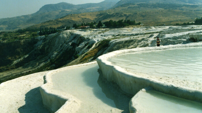
Hot springs exist the world over, from Japan to Scandinavia. But few spots match the Pamukkale Water Terraces for geological beauty. It takes a rare combination of factors to create a travertine terrace — hot enough water, springs that bubble up from a slope, and the perfect combination of minerals in the water. Mammoth Hot Springs in Yellowstone National Park is another example.
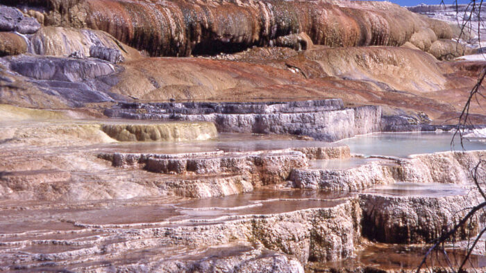
Hot but not too hot
But the water at Mammoth Hot Springs is dangerously hot, and sulfurous to boot. It wouldn't make a pleasing place to take a dip. Travertine terraces that throw in a precious fourth factor — friendliness towards the perpetually aching human body — are even rarer.
Terme di Saturnia in Italy is one such spot. For centuries, the tiny town of 300 has drawn visitors from around the world to its scenic pools.
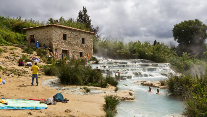
In that regard, Terme di Saturnia shares a lineage with the Pamukkale Water Terraces. As a Mediterranean country located at the crossroads of Europe and Asia, Turkey has been continually populated since the Late Paleolithic. It's likely that our Stone Age ancestors made liberal use of the Pamukkale Water Terraces to soak their tired muscles, as you would too if your life consisted primarily of either running from or chasing dangerous animals.
Nearly 3,000 years later, the combination of beautiful scenery and relaxing hot pools still attracts us. But as we'll see, such attraction comes at a cost to the landscape.
Early temple
The water terraces lie within the historical kingdom of Phrygia, which, according to Greek mythology, produced the legendary kings Midas and Gordias (of the famous knot). Modern archaeological digs indicate that the Phyrgians first built a temple there sometime in the 7th century BC, though likely people also lived there during the earlier Iron Age.
The original temple was a tribute to a Phrygian mother goddess named Cybele. Local spiritual traditions around Cybele purported that only her eunuch priests could survive inhalation of the gases emitted from the springs and surrounding caves.
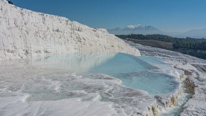
During the Hellenistic period — a time when Greek culture spread across the Near East, thanks to the efforts of Alexander the Great — the region was colonized by the Seleucid Empire, a nation of Western Asian Greeks founded by a former general after Alexander's untimely death.
The Selecuids built the city of Hierapolis sometime between 281 and 261 BC, using the site of the original temple as a starting place. (Hierapolis means "holy city.") After the city's founding, Cybele worship was absorbed into newcomers' religion, and the springs, terraces, and temple became associated with Hades and his consort Persephone. Greek doctors swiftly incorporated the waters into their healing practices, and people traveled from all over the ancient world to visit the site.
The Romans step in
But as always, when discussing hot springs and antiquity, we can't forget the Romans. The ever-expanding society took control of the region in 133 BC. A series of powerful earthquakes leveled Hierapolis during the reins of Emperors Tiberius and Nero. But the Romans never saw a pile of Hellenistic stones they failed to rebuild in their own image.
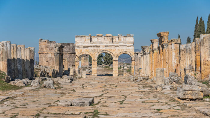
The Romans swiftly got to work building Roman-style baths, amphitheaters, gymnasiums, fountains, colonnaded streets, and other examples of their famous infrastructure. With the Pamukkale Water Terraces as a stunning focal point, Hierapolis became a thriving artistic and cultural center on the eastern fringes of the late Republic/early Empire.
Many luminaries of Roman society came to call Hierapolis home, including the famed Stoic slave-turned-philosopher Epectitus.
Rise and fall and rise again
The apostle Paul founded a church in Hierapolis during his ministry. As the influence of the early church spread over the centuries, Christian traditions gradually replaced the Hades-centered worship that had, in turn, replaced the mother goddess Cybele.
By 500 AD, Hierapolis and the Pamukkale Water Terraces were an important Christian site within the Byzantine Empire. But the coming turbulent centuries were not kind to the region. Persians sacked the city in the 7th century, and another earthquake destroyed what the Persians left behind. Inhabitants rebuilt again, only to see the city sacked by European crusaders in 1190.
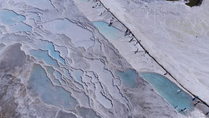
In 1354, a final earthquake completed the job. The last remnants of the ancient city toppled over, and time and elements covered the once-grand walls with sediment and stone.
Luckily, the same geologic activity that created the Pamukkale Water Terraces managed to spare the natural feature even as it toppled the structures mankind had built. As archaeologists in the late 1880s began excavating Hierapolis, contemporary travelers and tourists also rediscovered the Water Terraces. Perhaps inevitably, hotels sprang up, and foot traffic over the decades did the damage that centuries of earthquakes had been unable to do.
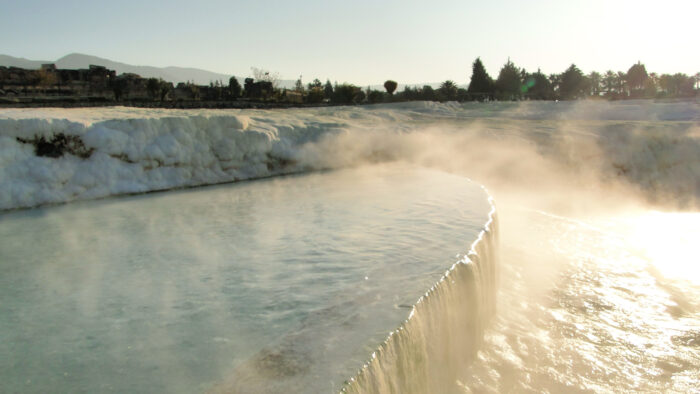
Luckily, Hierapolis-Pamukkale became a UNESCO World Heritage Site in 1988. Most of the hotels were torn down, and traffic in and around the Pamukkale Water Terraces was severely limited. While still a major tourist attraction today, the Terraces appear on track for preservation into the coming centuries and — hopefully — beyond.
The eruption of Mount Vesuvius in 79 AD has become the most famous volcanic eruption in history. This is largely thanks to Pompeii, the Roman city destroyed during the eruption and frozen in time, every resident cast in the position they perished in. But now, archaeologists have discovered two citizens of Pompeii that the eruption did not kill. It seems that two natural disasters struck the city at the same time.
During the eruption of Vesuvius, earthquakes also tore through the city. Italian archaeologists now believe that the eruption did not kill everyone. Some died from the earthquakes.
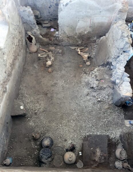
The Roman historian Pliny the Younger witnessed the eruption from a distance. His is the only first-hand account we have of the event. In his letters, he speaks of earthquakes, but there has been no evidence of them killing people until now.
“[The] earthquakes…that night became so intense that everything seemed not only to be shaken but overturning,” he wrote. "It was the first hour of the day, but the light was still faint and weak...The chariots we had ordered to be brought out, though on level ground, were shaken back and forth and did not remain steady in their places, even wedged with stones."
Until now, archaeologists have struggled to distinguish between damage caused by the earthquakes and the volcano because of the scale of the damage. The remains of two men have changed this.

Disaster puzzle
Experts agree the cataclysmic event at Pompeii had two main stages. First, ash clouds and pumice hit the city, caving in roofs and suffocating the townspeople. Then came the pyroclastic flow, a scalding hot cloud of gas and volcanic material. The mystery is when the earthquakes occurred.
“These complexities are like a jigsaw puzzle in which all the pieces must fit together to unravel the complete picture,” said archaeologist Domenico Sparice.
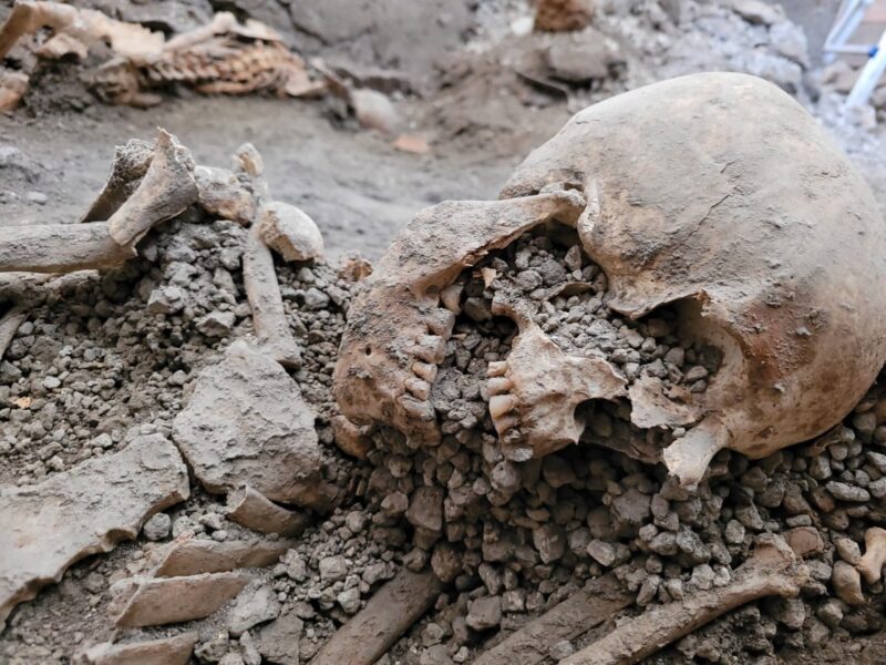
The two men, both around 55, took shelter in a large house in the city's center. Neither show signs of asphyxiation or dying from the immense heat. Instead, both died from blunt force caused by the collapse of the building they were in. Their skeletons show several bone fractures.
The researchers excavated the room where the skeletons were found, then carefully analyzed the layers of ash and pumice to untangle what occurred within the room. It turns out that the men's deaths occurred before the pyroclastic flow that entombed Pompeii.
"It was not just the collapse of structures associated with the accumulation of pumice or the impact of pyroclastic flows that represented the only dangers to the...inhabitants of ancient Pompeii,” concluded the archaeological team in a statement.
Archaeologists have been restoring the UK's oldest chalk figure, a 3,000-year-old outline of a horse, northwest of London. The Uffington White Horse dates back 3,000 years to the late Bronze Age.
Over time, the horse, carved into an Oxfordshire hillside, has been narrowing. Grass grew over the edges of the figure, shrinking parts of its head and neck to half their original width. This year, it received a much-needed facelift.
Work on the 111m long figure started last year. The team trimmed back the encroaching grass to what they think was the original outline of the horse and repositioned some of the top layers of chalk.
During the restoration, archaeologists took soil samples from the lowest layers of the horse. The first modern researchers in the 1990s dated the figure to the late Bronze Age, using soil samples. Since then, analytical techniques have improved significantly. The team hopes to get a more accurate date for the horse's creation using Optically Stimulated Luminescence. This technique uses the crystalline material in the soil to determine its last exposure to sunlight.
Why a chalk horse?
Though we know roughly when the horse was created, why it was built remains a mystery.
“It could have been a way of marking territory or as a tribal symbol,” suggests archaeologist Adrian Cox.
The horse is part of several ancient remains on White Horse Hill and the surrounding area. Uffington Castle, an Iron Age fort, stands at the top of the hill. It is approximately 220 meters by 160 meters and surrounded by a chalk bank. Excavations have found Iron Age structures within the fort and nearby burial mounds. Coins and pottery lie within those mounds, some of which date back to the Neolithic era. Others may have been used up to the time of the Saxons.
The first records of the abstract white horse come from the Middle Ages. It was listed as one of the Wonders of Britain, alongside sites like Stonehenge. Some believe the horse was a symbol of fertility or marked the territory of a nearby community. Others debate whether it's a horse at all. It may be a dragon, they suggest. Dragon Hill lies below White Horse Hill and is home to the legend of Saint George, who slew the dragon.
Over the centuries, the shape of the horse has changed slightly. Now it is a fairly abstract chalk design, but aerial images show that a more traditional horse shape seems to lie beneath it. Whatever its purpose, the chalk figure has been meticulously cared for since its creation.
Tended for centuries
Between the 17th and 19th centuries a "scouring festival" took place at the horse every seven years. Local people tended to the outline of the horse, cleared plants, and put down new layers of chalk. They then rolled cheese down the hill and feasted within the for, some 170m away. In World War Two, it was fully covered to stop enemy planes from using it to help their navigation.
“Through the efforts of generations of local people, the horse has been cared for, allowing it to survive for thousands of years to become an iconic feature of this landscape,” said Cox.
In the 14th century, the plague wiped out 50 million across Europe and Asia. It remains one of history's most fatal pandemics. But this was not the first time the bubonic plague hit Europe. It also caused the disappearance of Scandinavian populations thousands of years earlier.
Dubbed the Neolithic Decline, huge numbers of northern Europeans started to die out 5,000 years ago. This continued for 200 years. What happened has always been a mystery. A 2019 study proved that the bacteria that caused the plague was present in the region at the time. But no one could decipher how much this caused the downfall of Europe’s first farming communities.
The new study analyzed the teeth and bones of 108 individuals from Sweden and Denmark. All remains date between 5,300 and 4,900 years ago.
"Eighteen of these individuals, 17 percent, were infected with the plague when they died," said lead author Frederik Seersholm. "Furthermore, our results suggest that the youngest plague strain we identify might have had epidemic potential."
The team identified three different strains of the pathogen. The first two were found in a few remains. But the third was more prolific. The researchers believe this is the strain that had such a devastating effect. The fact that one individual in six carried the plague indicates that the disease was widespread in Scandinavia at the time.
Better farming = more people = spread of disease
The Neolithic period featured an agricultural revolution. Farming came to Europe 9,000 years ago and flourished for 5,000 years. These first farmers originated in the eastern Mediterranean and had fairly advanced farming techniques, settlements, and monumental tombs such as Stonehenge.
Then, it was as if someone had pressed pause. For the next few hundred years, the settlements were abandoned, ritual burials stopped, and some agricultural knowledge disappeared.
But as farming blossomed 5,000 years ago, so did communities. Populations increased, and people began to live close to one another. Once a single member contracted the plague, it would, in theory, have spread quickly.
Seersholm acknowledges that this pandemic may just have been a contributing factor and that other circumstances could also have played a role.
In 1250 AD, a cluster of earthen mounds by the Mississippi River swarming with artisans, farmers, and even astronomers was the place to be. It was known as Cahokia.
By 1350, it was a ghost town.
Why?
Located across the Mississippi River east of modern-day St. Louis, Cahokia was in its day the largest North American city above Mexico. Its 20,000 souls belonged to a group of Algonquian-speaking tribes from across the lower Midwest. They survived by farming.
Generations of archaeologists have carved away at the soil in the U.S. state of Illinois to find out what happened in those hundred years to cause the thriving town's demise. Researchers have now discarded one of the most popular theories, that severe drought caused crop failure. Prairie grasses, the theory went, then moved in during the drought, replacing crops like maize and squash with inedible roughage.
The tidy hypothesis followed other tales of civilizational extinction. But according to the U.S. Bureau of Land Management (BLM) and Washington University in St. Louis, it didn’t happen.
"Given the diversity of their known food-base, the domesticated landscape around Cahokia may have been resilient in the face of climate change and capable of producing more food than was required by Cahokians," the researchers wrote in a paper published last month.
Scratch the most popular theory of their mysterious disappearance.
View this post on Instagram
No catastrophes
Soil samples extracted from deep underground reveal that no catastrophic crop failure occurred. The study’s co-authors counted carbon isotopes in the soil from throughout the Cahokian period. If particular isotopes kept showing up in layer after layer of soil, they would paint a picture of consistent soil composition over time. In turn, this would indicate whether drastic changes in cultivation had taken place.
The study revealed a consistent presence of Carbon-12 and Carbon-13 across samples. No major death of one dominant plant species — or growth of another — had occurred.
"We saw no evidence that prairie grasses were taking over," said archaeologist Natalie Mueller, who led the study.
However, that doesn’t mean a drought didn’t happen — it just means the Cahokians may not have perished under its pressure.
Co-author Caitlin Rankin of the Nevada Bureau of Land Management said the Cahokians were good enough engineers to keep crops irrigated through dry cycles. They were such skilled builders that Monks Mound, an iconic prehistoric earthwork, is the largest pyramid north of Mesoamerica.
So why did the Cahokians abandon their proud city? One separate theory, also using soil cores, focuses on flooding along the ancient Mississippi.
Rankin and Muelle aren’t sure yet. For now, they suggest that the abandonment happened slowly.
The discovery of bones in a Tibetan cave 3,280m above sea level suggests that the little-known Denisovans lived on the high, arid plateau for millennia.
Researchers found over 2,500 bones in the Baishiya Karst Cave, which is one of just two places where we are sure the Denisovans lived. The elusive hominins were contemporaries of both Neanderthals and Homo sapiens. There is evidence that they interbred with both groups.
The few known Denisovan remains lie within only three caves. We have no idea when or why they died out, which means that every discovery about them is invaluable. Their presence on the harsh Tibetan Plateau gives an insight into the ancient humans' ability to survive a wide range of climates and diets.
The recently discovered bones include one Denisovan rib that dated to between 48,000 and 32,000 years ago. This is the same time that Homo sapiens were spreading across Eurasia. We already have evidence that these ancient humans lived in this area 190,000 years ago. The new fossil suggests they endured two cold periods and a warmer interglacial period between the Middle and Late Pleistocene eras.
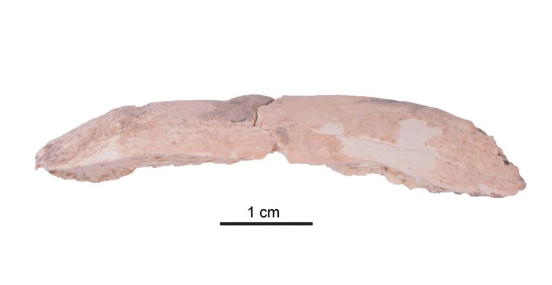
Good place to live, despite altitude
"The fossil and molecular evidence indicates that Ganjia Basin, where Baishiya Karst Cave is located, provided a relatively stable environment for Denisovans, despite its high altitude," said Frido Welker, co-author of the study. "The question now arises when and why these Denisovans on the Tibetan Plateau went extinct."
Nearly all other bones within the cave belong to animals and indicate the diet of these ancient humans. Unfortunately, the bones were in such small fragments that they were nearly impossible to identify by sight. Instead, the researchers analyzed the bone collagen using mass spectrometry to figure out what species they belonged to.
The vast majority came from blue sheep, small birds, wild yaks, equids, woolly rhinos, and spotted hyenas. The markings on the bones show how adept the Denisovans were at hunting and using all parts of the animals they caught. Markings on the surfaces show they stripped all meat from the bones and removed all the bone marrow. Many fragments had also been fashioned into tools.
The study “reveals new information about the behavior and adaptation of Denisovans both to high altitude conditions and shifting climates," said one researcher. "We are only just beginning to understand the behavior of this extraordinary human species.”