BY WILL BRENDZA
Texas is getting its very own long-distance cross-state thru trail thanks to one ambitious outdoorsman with a vision. The Cross Texas Trail (xTx) would extend 1,500 miles from Orange to El Paso, winding along some of the Lone Star State’s most scenic landscapes, passing towns and many historical sites, gaining roughly 56,000 feet in elevation along the way.
The nonprofit organization behind the xTx describes it on its website as “the future Pacific Crest Trail of Texas.”
Veteran trail hiker, bike-riding adventurer, and Texas native Charlie Gandy is leading the charge in establishing the xTx. The former Mesquite and East Dallas resident first had the idea when he was hiking the Tahoe Rim Trail (TRT) in June 2024.
He saw the power that cross-state trails had to connect people, uplift communities, and transform the individuals on them. He was a few days into his hike when it hit him.
“I could see a route across [Texas],” said Gandy. “I just wasn’t sure how I was going to get it done at that point.”
While people could technically hike the route now, Gandy hopes to have it officially established in the near future. At that point, it will be open season for thru-hikers, bikers, and horse riders who want to traverse the state of Texas by trail.
Currently, he’s asking for help from hikers, bikers, and equestrians who can help “ground proof” sections of the trail. Then, in spring 2026, Gandy intends to thru-hike the entire trail himself, and he’s inviting anyone to join him on the adventure.
xTx: The Pacific Crest Trail of Texas
Gandy graduated from the University of Texas and worked under the governor before starting several businesses of his own. He’s a serial entrepreneur, but he also has a history in the nonprofit world. He founded BikeTexas.org, the first statewide bike advocacy group in Texas. Now, he’s also founded xTexas.org.
In his spare time, he’s also an avid and fairly accomplished hiker. “I’ve hiked all of the fourteeners in Colorado and almost all of them in California and elsewhere,” he told me.
He revealed his plans for the xTx at the Texas Trails and Active Transportation Conference in September. He called the initiative kind of a wild ride, but said the response from both the hiking community and most of the locals he’s heard from has been positive.
“This is a big, hairy goal that I get to undertake,” Gandy said. “It kind of has a life of its own.”
The trail will be a mix of singletrack and about 40% gravel roads. It will showcase the diverse environments, scenic landscapes, and cultural variety that span the largest state in the contiguous U.S.
Gandy also hopes the xTx will draw visitors who will bring business to the communities it passes through. “It’s a new opportunity to have a different type of customer in town,” he said.
Crossing Texas: no easy endeavor
xTx Thru-Hike: the route
Miles 0-200
Miles 200-500
Miles 500-1,200
The Home Stretch
Getting xTx Thru-Hike across the finish line
xTx Thru-Hike: regional breakdowns & highlights
Eastern Piney Woods to Hill Country
Ecosystems
Towns
Central Hill Country to Big Bend
Ecosystems
Towns
Western Desert Section & Big Bend
Ecosystems
Towns
What to bring on the xTx Thru-Hike
Hazards on xTx Thru-Hike
Heat & hydration
Snakes & insects
People
This story first appeared on GearJunkie.
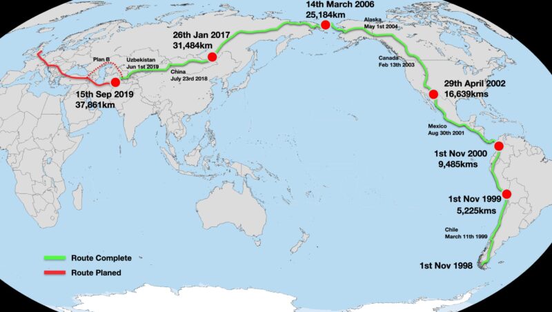
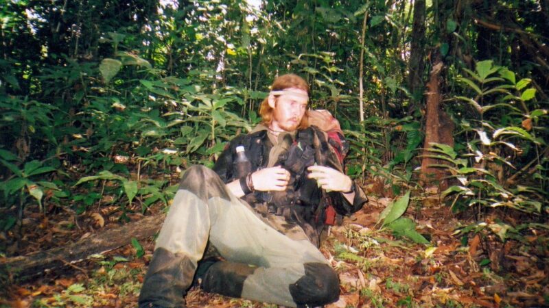
British adventurer Karl Bushby is nearing the end of his extraordinary journey to become the first person to walk an unbroken path around the world. Beginning on November 1, 1998, from the southern tip of Chile, Bushby has trekked over 47,000km across four continents, 25 countries, six deserts, and seven mountain ranges. Now he is starting his final year on the road.
His odyssey, known as the Goliath Expedition, has spanned 26 years, with approximately 13 years spent actively walking and the remainder consumed by bureaucratic challenges, pandemics, visa restrictions, and financial difficulties.
Two rules
Bushby has two self-imposed rules: he cannot use any form of transportation on his route, and is not allowed to go home until he is finished. Logistical problems have occasionally forced him to put his trek on hold for up to three years and fly to Mexico or elsewhere to cool his heels. But always, he picked up where he had left off and did not use anything but his two feet on the route itself.
His path took him through multiple conflict zones, including the infamous Darien Gap between Colombia and Panama. Crossing the 320km stretch of jungle took him two months and included an 18-day detention in Panama before he was allowed to proceed.
Continuing northward, Bushby crossed Central America and entered the United States in 2002, eventually reaching Alaska in 2005. In March 2006, he achieved a significant milestone by crossing the Bering Strait on foot with French adventurer Dimitri Kieffer. The duo spent 14 days navigating a frozen 241km section to cross into Siberia, a supremely difficult task over broken, swiftly moving ice. Here, Russian border authorities detained them for not entering at an official port.
Difficulties in Russia
Bushby's progress through Russia was slow due to visa restrictions. He had to leave the country every 90 days, since his tourist visa only allowed him to stay in Russia for 90 days of every 180 days.
In 2008, his journey came to a standstill. He lost sponsorship for a few years and could not travel to Russia, so he set up camp in Mexico until he found more funding. In 2011, he resumed his trek, once again in 90-day stints. Then in 2012, he was denied a further visa, and in 2013, he received a five-year entry ban from Russia.
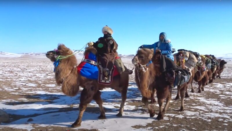
Determined to continue, Bushby headed to the U.S. and walked 4,800 km from Los Angeles to the Russian Embassy in Washington, D.C., to protest the decision. His efforts weren’t wasted. In 2014, the ban was lifted, and he once again found himself in Russia. From there, he continued through Mongolia, where he joined with other adventurers (including Angela Maxwell, also on a solo walk around the world) to trek across the Gobi Desert with camels.
After 1,130km, several disagreements fractured the group, and Busby continued into China by himself. In 2018, he crossed Kazakhstan and then made his way through Uzbekistan and Turkmenistan. Here, his journey came to a premature halt when he could not secure a visa to his next country, Iran. The pandemic also set in around this time. He once again retreated to Mexico.
An odd Plan B
In 2022, facing insurmountable obstacles in Iran and Russia, Bushby devised an odd plan B for someone who had spent well over a decade walking. He was going to swim across the Caspian Sea with Angela Maxwell, but even this plan took two years to pull together.
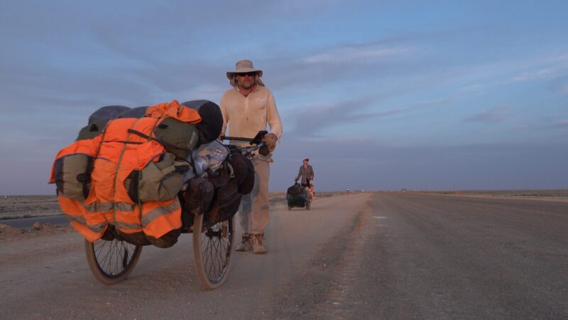
Bushby and Maxwell flew to Bukhara, Uzbekistan, and walked across the Kyzylkum Desert to the Caspian Sea. With limited swimming experience, they embarked on the 288km swim from Kazakhstan to Azerbaijan in October 2024. Over 32 days at sea, they spent 27 days swimming through dangerously rough seas and high winds. Safety boats accompanied them. They swam for three hours in the morning and three hours in the afternoon and slept aboard the boats.
But swimming was not the hardest part of this challenge. Bushby admitted, “I’m definitely not a swimmer, nor do I like swimming.” For both of them, this was completely outside their comfort zone.
For the last six months, Bushby has been picking his way from Azerbaijan to Turkey. Speaking to Turkiye Today, he said, “Other travelers told me Turkey would be one of the most beautiful and welcoming places. And they were absolutely right. People constantly invited me into their homes...The hospitality has been amazing.”
One year more
Now he is just days away from Istanbul and is trying to secure permission to cross the Bosphorus, “It’s only 1.5 kilometers, but it’s symbolic,” he explained. "Crossing it would bring me from Asia into Europe, the final phase of the journey. From there, I’ll walk across Europe and reach the Channel Tunnel in France, eventually walking back home to the UK."
Once he crosses the Bosphorus, he is confident it will only take him one more year to get back to the UK. “It’s been hard being away. And the U.K. has changed so much — I left when Tony Blair was Prime Minister. Since then, we’ve had five or more PMs. I might not even recognize home when I get there.”
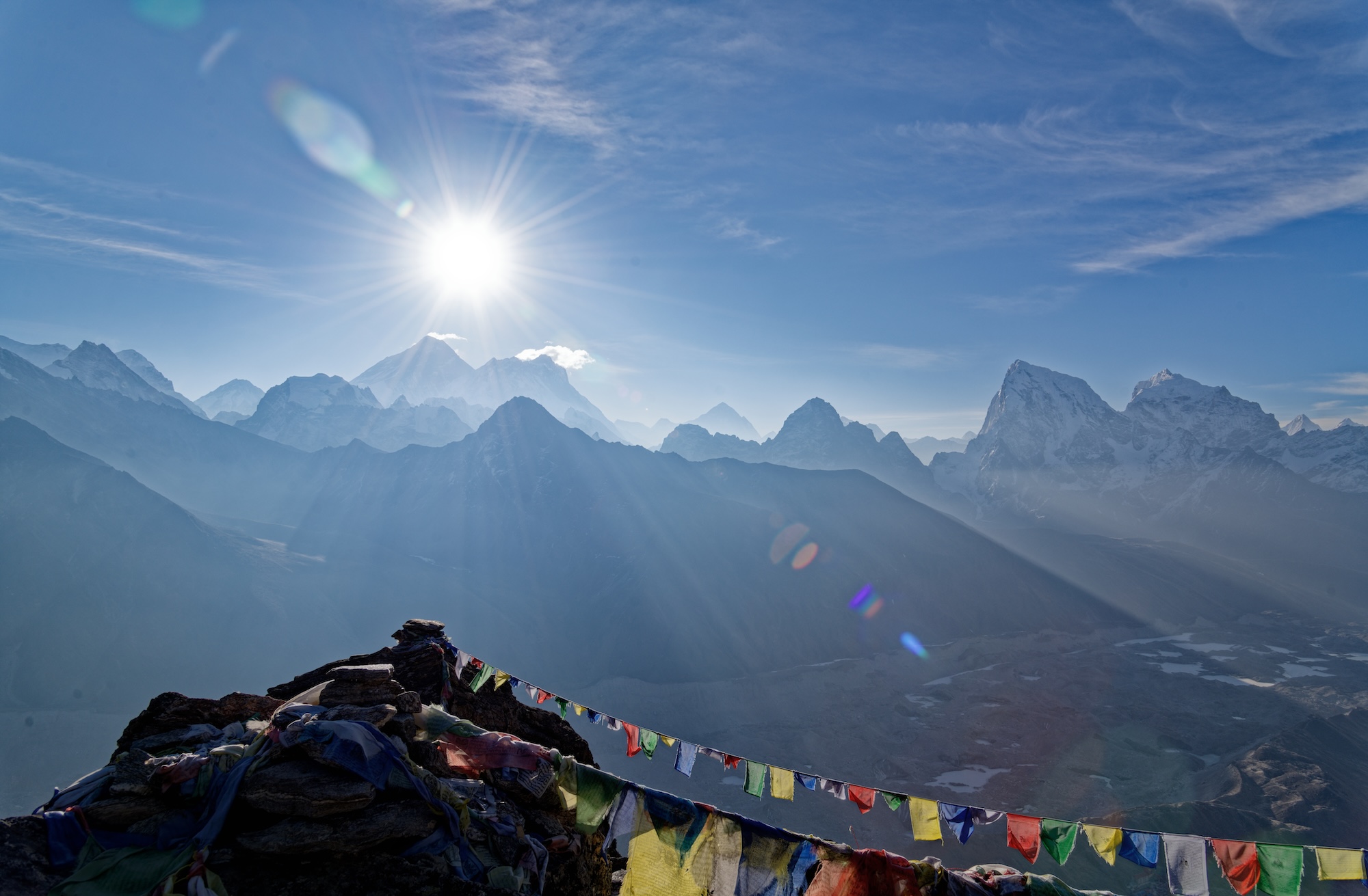
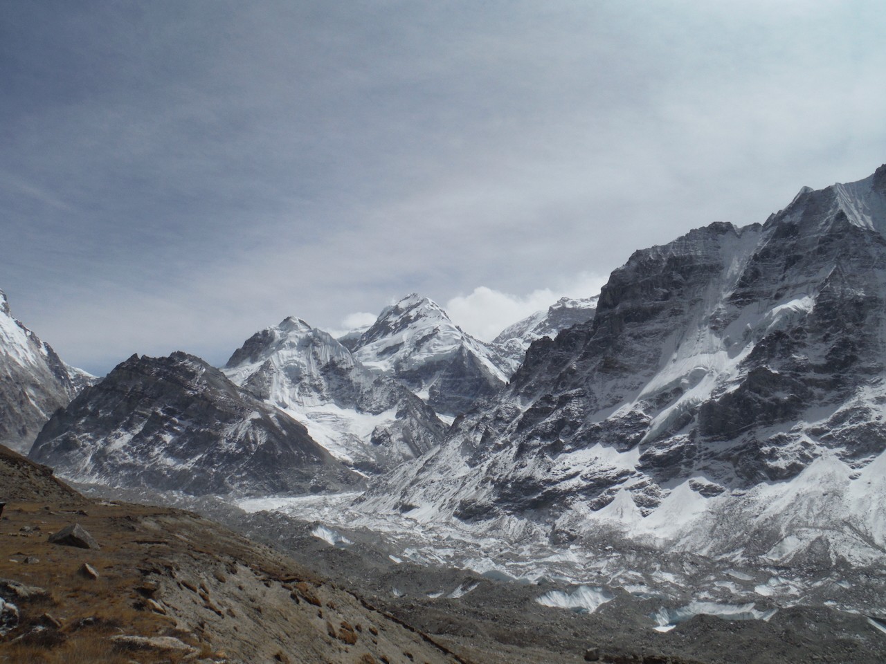
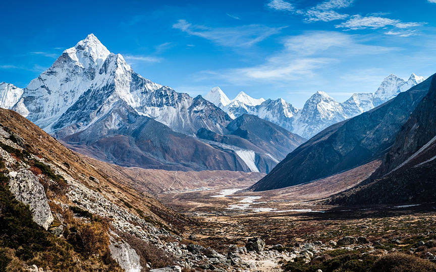
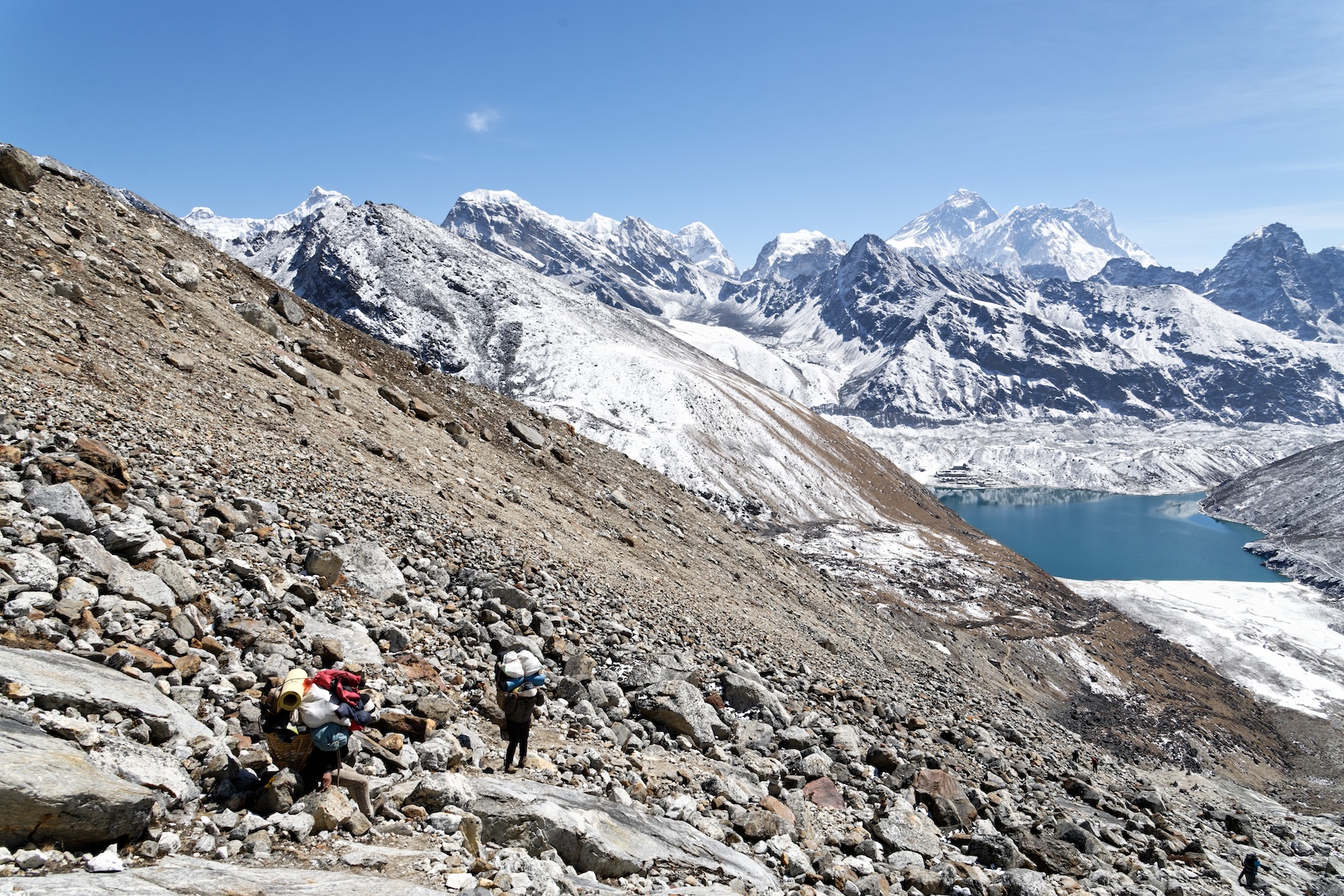
Nepal's Great Himalaya Trail runs 1,750km across the entire country and passes over some of the highest trekking passes in the world. Here in Part II, we examine the route and hear from those who have completed the GHT. You can check out Part I here.

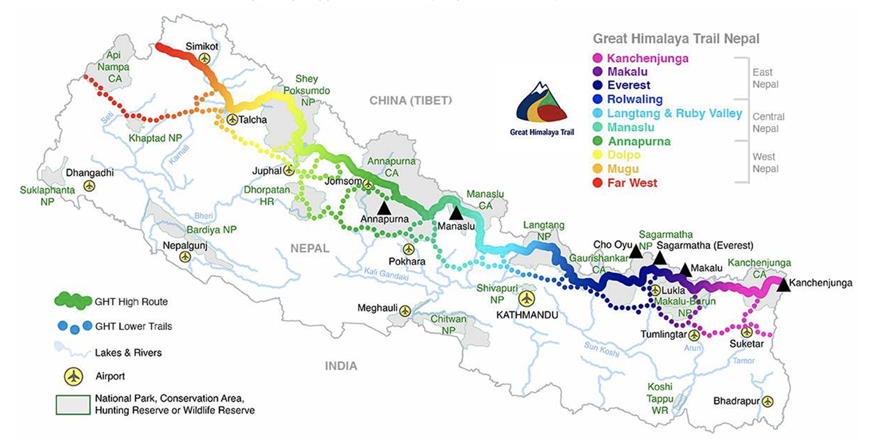
Rolwaling
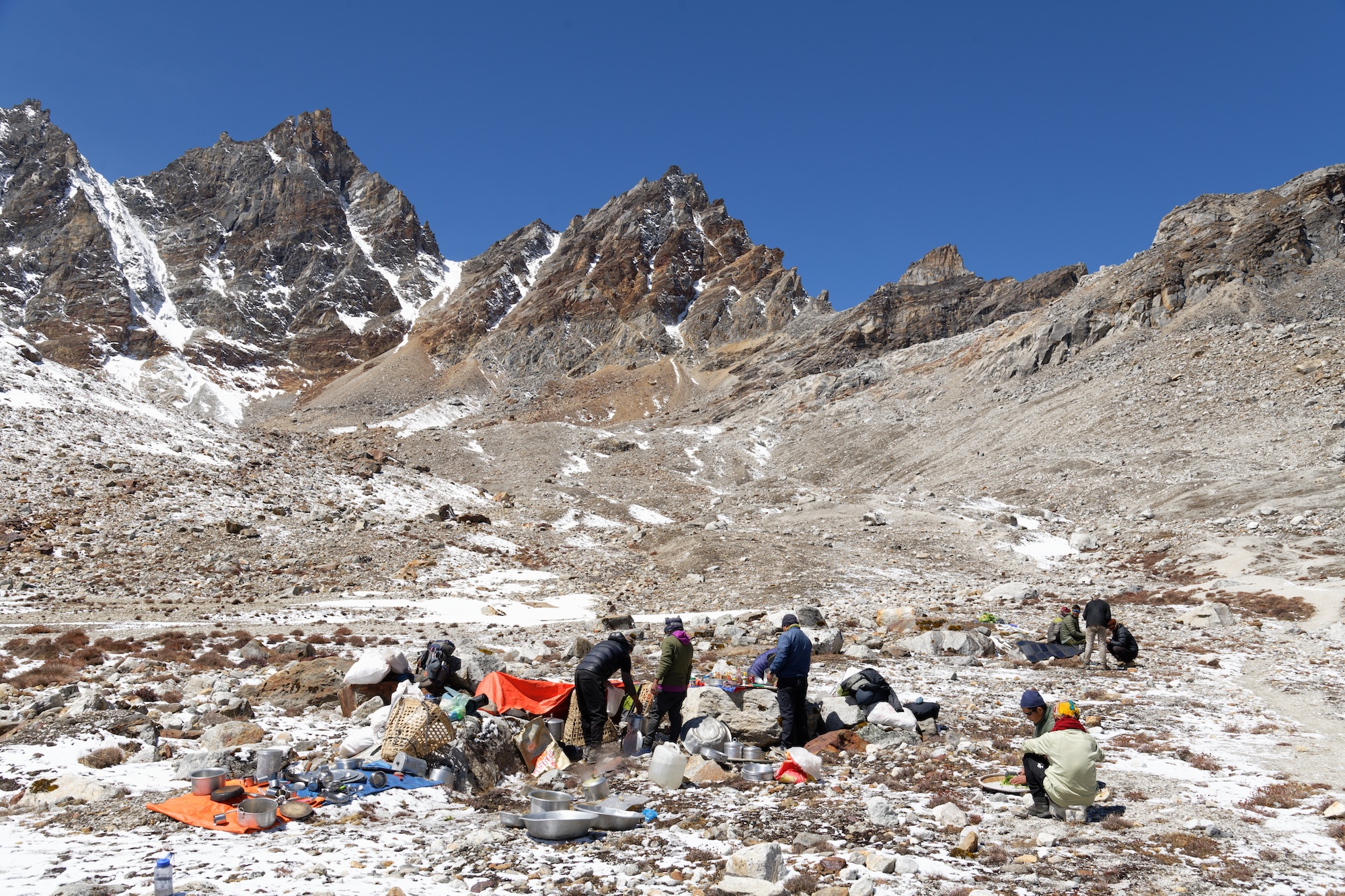
Tashi Labsta (5,760m) is quite technical and can require fixing ropes. Rockfall can be a problem here. Like Sherpani Col, weather and snow/ice conditions might require a flexible schedule. World Expeditions takes two days on the approach to assess the weather and camp high (5,665m) before the crossing. The pass is close to Thame, roughly 10km away, but 2,500m above the village!
Route finding on both the approach and the pass can be tricky if there’s snow. The “glaciers on the eastern side of the pass are hazardous and crevassed,” Boustead explains on his GHT website. Boustead also notes that food can be hard to come by in Rolwaling, so independent hikers should stock up before the pass.
After the saddle, most trekkers descend to the Trakarding Glacier for a cold night’s camping. Jasmine Star, who hiked half the GHT in 2016 and the other half in 2019, described the descent as the most challenging section.
“It’s hard on the way down," she says. "There are some immense boulder fields after the pass. They go on for like a day, day and a half before you reach a proper trail again.”
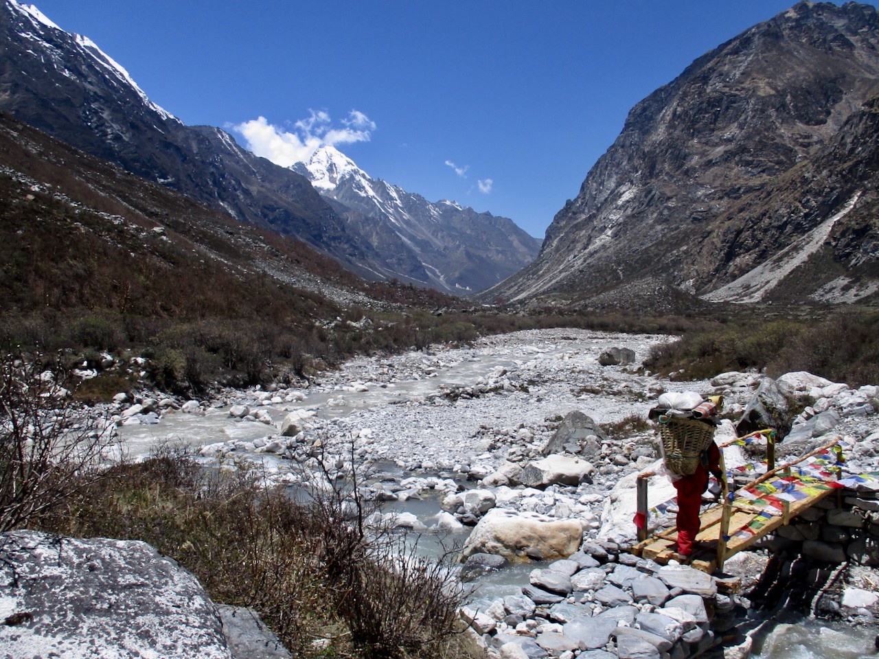
The next five to seven days are more relaxed, following rivers and meandering through remote villages in Rolwaling. This section of the GHT finishes at Sano Jynamdan.
Langtang and Ruby Valley
The trail then winds through the villages of Listi, Bagam, Kyangsin, and Dipu. This section is “Nepali flat,” meaning undulating without any big climbs. Then, it’s back to ascending, with a 1,000m+ elevation gain to Kharka and then another 500m to Panch Pokhari at 4,074m.
After a couple more days of gradual ascent, there’s the first high pass in some time. Tilman’s Pass (5,308m) involves some scrambling, and loose rock may cause problems, but it should be doable in a day.
After a night camping just below the pass, the route joins the main Langtang Trail. This means teahouses, relative luxury, and a well-trodden, clearly marked trail. Depending on fitness, speed, and weather conditions so far, hikers can expect to be between 60 and 80 days into the GHT at this point, a little over halfway through.
The next few days are known as the Ganesh link of the GHT, connecting Langtang to the Manaslu and Annapurna regions.
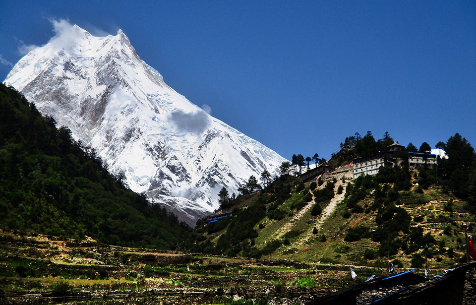
Manaslu and Annapurna
The trail now drops like a stone to 1,503m at the small village of Syabru Besi. The next few days follow a similar pattern. The trail climbs to ridgelines and then descends into valleys and basins (later dipping even lower to 970m), with small villages scattered along the route. This area is the Ruby Valley.
Over several days, you gain altitude again, culminating in a crossing of Larkye La at 5,140m. Along the way, you skirt the edge of the Kutang Himal, a natural barrier that marks the border between Nepal and Tibet. With more elevation, there’s also the return of mountain panoramas, with views of Himalchuli (7,893m), Peak 29 (7,871m), and Manaslu (8,163m). In clear weather, there are good views of Annapurna II (7,937m) from Larkye La.
The trail follows the Marsyangdi River downstream, descending quickly. Leaving Manaslu behind, you enter the Annapurna region. The Annapurna circuit is popular, and the trail is clear, with plenty of places to stay along the route.
You gain altitude again toward Thorong La (5,416m), the highest point in the 300km Annapurna circuit. This pass is a long, arduous day. Tour companies offering Annapurna Circuit treks usually list it as the longest day, with a pre-dawn start to avoid the notorious Thorong winds and 9 to 12 hours of hiking required. It’s not technical, but a long, gradual slog, with several false summits and then a 1,500m descent to Muktinath.
With the Annapurna range now behind you, it’s on to Dolpo.
Dolpo
The Dolpo-pa, a semi-nomadic ethnic group of Tibetan descent, inhabit 24 villages in this region. It’s a remote, rugged bit of the Himalaya with few trees, but the trail is mostly well-marked.
“The GHT provides many variations of ethnicities, religions, and cultures, but the Far West is particularly different,” guide Bir Singh Gurung explained. "Dolpo has its own pre-Buddhist beliefs, such as Animism (Bon) religion and pure Tibetan culture."
Gurung has guided in the Nepalese Himalaya since 1999. He said this was his favorite section of the GHT “because of its remoteness, the wilderness, rich culture, and the landscapes.”
After Muktinath, the trail leads to Kharka, before two sub-5,000m passes bring you to the village of Santa. Another day or two takes you to Lalinawar Khola (river), at the base of 5,550m Jungben La, with great views of Hidden Valley and Dhaulagiri, and 5,120m Niwas La. After quite a few days at lower altitudes, these passes can prove challenging, but both can be completed in around seven hours at a steady pace.
After the passes, the trail descends to another river, Chharka Tulsi Khola. The path flicks between the two sides of the river as you move up the valley. Another high pass rears up ahead, Chan La (5,378m), but it has an easy gradient and is not technical.
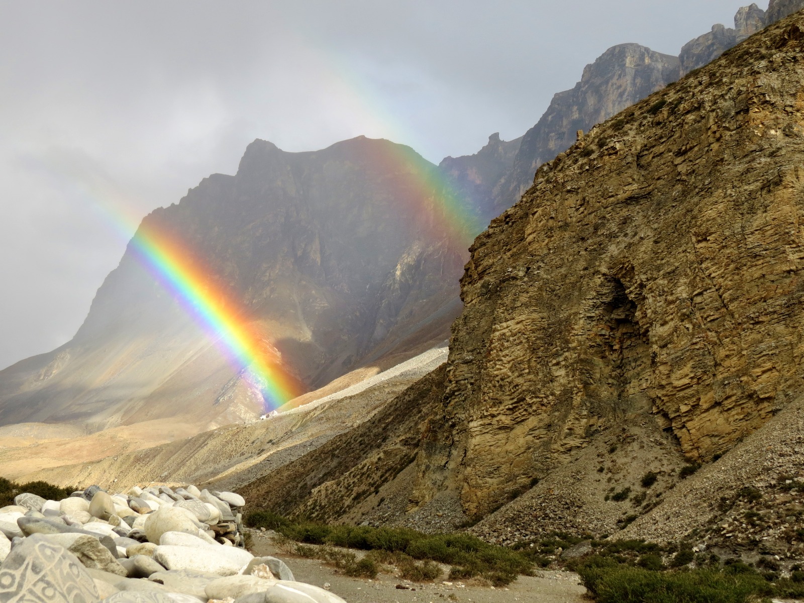
Descending to the trading village of Dho Tarap, the trail soon climbs again to Jyanta La (5,100m) en route to Saldang, the administrative center for Upper Dolpo. From there, it’s an easy day to Shey Gompa, an 11th-century Buddhist monastery.
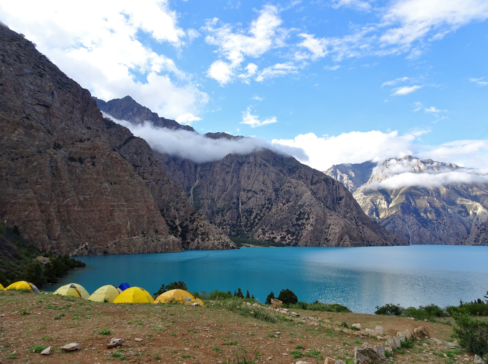
The next two days follow the trail across 5,350m Nagdala Pass to the famously beautiful Phoksundo Lake.
The Far West: Rara Lake & Yari Valley
From Phoksundo Lake, you enter Nepal’s Far West, the least visited region in the country and the final segment of the GHT.
Crossing Kagmara La (5,115m) is a long, two-day effort, but the next five or six days are fairly easy. The trail drops and winds through a few villages on the way to Rara National Park and Rara Lake, the largest lake in Nepal.
Depending on your pace (and your start date), the monsoon rains could begin around this time. If so, expect heavy deluges, muddy boots, and leeches.
From Rara Lake, there are two GHT options: From Gamgadhi to Simikot and the Yari Valley, or cross-country to Kolti and Chainpur and on to the Mahakali Nadi River in India. World Expeditions elects to take clients on the Gamgadhi to Simikot and Yari option because “this route travels closer to the center of the Great Himalaya Range.” But independent trekkers will find either route interesting and little visited.
Assuming you take the “upper” route, you leave Rara Lake for Karnali. Following a familiar pattern for the next week, you climb over ridges and then descend into basins and valleys, never surpassing 4,000m and sometimes dropping below 2,000m. At Shinjungma, the main trail branches away, heading further north toward the border with Tibet. It eventually finishes at the town of Hilsa.
How long does it take?
Finishing times vary considerably. The Great Himalaya Trail website suggests 120-140 days, World Expeditions schedules 150 days (including getting to and from start and end points), and some speedy independent travelers knock it over in around 100 days.
Difficulty, fitness, and training
World Expeditions rates the GHT a 9/10 on their difficulty scale (the highest rating of any of their treks), grading it as an intermediate mountaineering expedition. While they don’t require mountaineering knowledge, they do check fitness levels and previous hiking experience when people wish to sign up.
Heather Hawkins completed the GHT (guided and supported by World Expeditions) with her adult children. Heather is a marathon runner, and she describes the whole family as having a good fitness foundation, with plenty of hiking and bushwalking under their belts. Only her son had climbing experience, but the tour company provided training with jumars, crampons, and using fixed ropes before they hit stage two of the GHT and the high, technical passes.
“We were with climbing sherpas, and I felt very safe and well looked after,” Hawkins said.
Likewise, Jasmine Star (also guided and supported) had great base fitness before taking on the GHT. She had previously finished Bhutan’s famous Snowman Trek and had some mountaineering experience. Star managed a mountaineering lodge on Mount Hood in the 1990s and had previously climbed Mount Rainier.
“The eastern half is very hard because of all the snow,” Star said. "Sleeping, walking in snow, snow on high passes. It’s draining. The West is easier. We had three people start on the full traverse [from east to west], and one asked to be evacuated by helicopter after 27 days, which was very tricky. Different people joined for various sections of the traverse, including six people for stage two. Some suffered altitude sickness and quit to hike out to Lukla after Amphu Labsta.”
Stage two (Makalu & Everest) is the consensus crux of the route. Professional guide Soren Kruse-Ledet trekked most of the route in 1998, but from Mount Kailash in Tibet to Kangchenjunga in Eastern Nepal, and now guides sections of the GHT.
“Stage two is the most challenging as it includes Sherpani Col and West Col,” Kruse-Ledet said. "Both of them are over 6,100m, plus an additional three passes over 5,000m. It’s high altitude, remote, and technical."
He went on: "I have had situations where clients or staff have experienced altitude sickness, which can have quite a sudden onset. We’re trained and prepared to manage these situations, but we are keenly aware of the risks. But, while challenging, it is also exceptionally beautiful. You experience views of Everest and Makalu in a part of the Himalaya that doesn’t see many other travelers."
Kruse-Ledet doesn’t think the GHT is beyond most fit, outdoor people.
“I think it’s challenging because of the length of time that you’re on the route. The difficulty is not necessarily the physical aspect but the psychological challenge of having to walk nearly every day for five months. Overall, I would describe this as a difficult trek for committed and experienced walkers.”
Guide Bir Singh Gurung concurs: “Mental and physical fitness is necessary. Socially [it is different], it is a diet you are not familiar with, and comfort levels are different. You need great willpower and determination. Experienced trekkers with basic mountaineering skills are ideal.”
Vince Gayman completed the GHT guided and supported in 2018.
“I had limited mountaineering experience,” Gayman said. "I had done some glacier travel with crampons and had climbed a couple of our local peaks with ropes and an ice axe, but nothing very extensive. For someone with no experience and traveling without guides, [stage two] would be VERY challenging."
Independent vs. guided
There are several things to consider when choosing between independent and guided GHT hikes. The first may be cost.
Boustead estimates costs for independent trekkers as follows:
Go solo as much as possible: $13,500
Twin-share with minimum guiding: $7,250 per person
Solo “as much as possible” is key. Restricted Area Permits (RAPs) are required for some areas. These are for a minimum of two foreigners (making a true solo journey considerably more expensive) and require a local guide. Those completely adverse to a guide reportedly hire one to pass certain checkpoints and then release them in between. Please note that we are not advising people to do this.
At the time of writing, RAPs are required for 15 areas of Nepal: Upper Mustang, Upper Dolpo, Lower Dolpo, Tsum Valley, Manaslu Areas, Gosaikunda Municipality, Nar and Phu Trek, Khumbu Pasang Lahmu Rural Municipality Ward Five, Humla, Taplejung, Dolakha, Darchula, Sankhuwasabha, Bajhang, and Mugu.
Guided tours are, of course, much more expensive. Tour companies charge $25,000-$30,000 for a fully supported traverse (including guides, porters, accommodation, food, permits, and transport to and from the GHT).
Other things to consider include how much gear you want to/can carry, your tolerance for complex logistical planning (where to stay, how much money to carry, what permits you need, etc.), your desired pace, your fitness/alpine experience, and your route-finding abilities, particularly on the high passes and if the weather is poor.
Pace might seem a minor consideration, but larger groups move much slower, and for the speediest independent hikers, even a single guide can prove a drag.
“Some of the high passes require a fixed rope for safety,” Gayman explained. "This makes for slow going, especially with a large team carrying lots of gear. Needless to say, there is quite a bit of stop-and-go to keep everyone safe. For us, the weather was amazingly good and the views spectacular, so the pace wasn’t a problem.
Thru-hiking is a distinctly American term, but long-distance hiking routes aren’t limited to North America. The Great Himalaya Trail (GHT) might eventually encompass a continuous route through Bhutan, Nepal, and India. But for now, the Nepali GHT already offers an almighty 1,750km journey across the entire country and passes over some of the highest trekking passes in the world. Here, we examine the route and hear from those who have completed or guided the GHT.
History of the GHT
Hiking long-distance across the Nepali Himalaya is not new. Locals have covered vast distances since time immemorial, and foreign hikers have completed traverses starting in at least the 1980s.
Notable early long-distance hikers included Peter Hilary (son of Edmund Hilary) Chhewang Tashi, and Graeme Dingle walking from Sikkim, India, to the K2 Base Camp in the Karakorum in 1981, and Hugh Swift and Arlene Blum's nine-month traverse from Bhutan to Ladakh, India between 1981 and 1982.
More recently, in 1997, Frenchmen Alexandre Poussin and Sylvain Tesson hiked an impressive 5,000km in six months, from Bhutan to Tajikistan.
There have been numerous runners who’ve tackled large distances, too. Richard and Adrian Crane ran from Kanchenjunga to Nanga Parbat in 1983 and in 2023 Rosie Swale-Pope ran 1,700km across Nepal. But both of these trips deviated a long way from what is now the GHT. Swale-Pope ran in Nepal’s mid-hills, and the Crane brothers went far enough south to cross into India.
The modern GHT is a relatively new concept. Between 2008 and 2009, Robin Boustead traced a path over 162 days, linking trekking sections that became the most commonly used route.
The high route
There’s both a high and a low route through Nepal. Hikers can easily switch between them, depending on the weather and their tolerance for high-altitude passes. Often you can adapt the route to suit you. This is a network of trails rather than a singular route. But here, we’ll concentrate on one version of the high route.
Most trekking companies divide the route into three regions, East, Central, and West Nepal, and seven (or more) stages: Kangchenjunga, Makalu & Everest, Rolwaling, Langtang & Ruby Valley Link, Manaslu & Annapurna, Dolpo, and finally Nepal’s far west, Rara Lake and Yari Valley.
Hikers tend to start in the east in early March. This is a couple of weeks earlier than the typical trekking season, and it will still be cold with plenty of snow, making for a tough start.
But there is a good reason to start so early. Hikers need to complete the highest passes before the monsoon rains arrive in mid-June. This is also why most people start in the east rather than the west. The GHT’s highest, most difficult passes are bunched in the east and would potentially be more dangerous later in the year.
East Nepal: Kanchenjunga
It’s quite the slog just to get to the eastern starting point of the GHT, though it won’t tax your legs. From Kathmandu, you fly to Bhadrapur, tucked into the far south-eastern corner of Nepal on the border with West Bengal, India. From there, it’s a long drive as far north as the roads will take you to Chiruwa. The drive usually takes two long days.
After Chiruwa, you’re on foot, continuing north, parallel with the Indian border, toward Kangchenjunga in Nepal’s northeast. You start low, at around 1,600m, acclimatizing gradually as you push north. Three to four days of hiking brings you to Ghunsa (3,430m), the last village in the area that is inhabited year-round.
Over the next three days, hikers ascend quickly, climbing scree and lateral moraine to Kangchenjunga Base Camp at 5,143m. This marks the furthest east you’ll travel. Hikers then retrace their steps back to Ghunsa before the first pass of the GHT: Nango La.
At “only” 4,776m, Nango La is not terribly high, but this early in the season, it can still be tricky, with deep snow. Once over the pass, you drop over 1,000m, heading to the village of Olangchung Gola. It’s possible to do the pass and reach Olangchung Gola in one extremely long day, but most hikers choose to find a camping spot once they’ve descended the pass.
Makalu and Everest, the crux
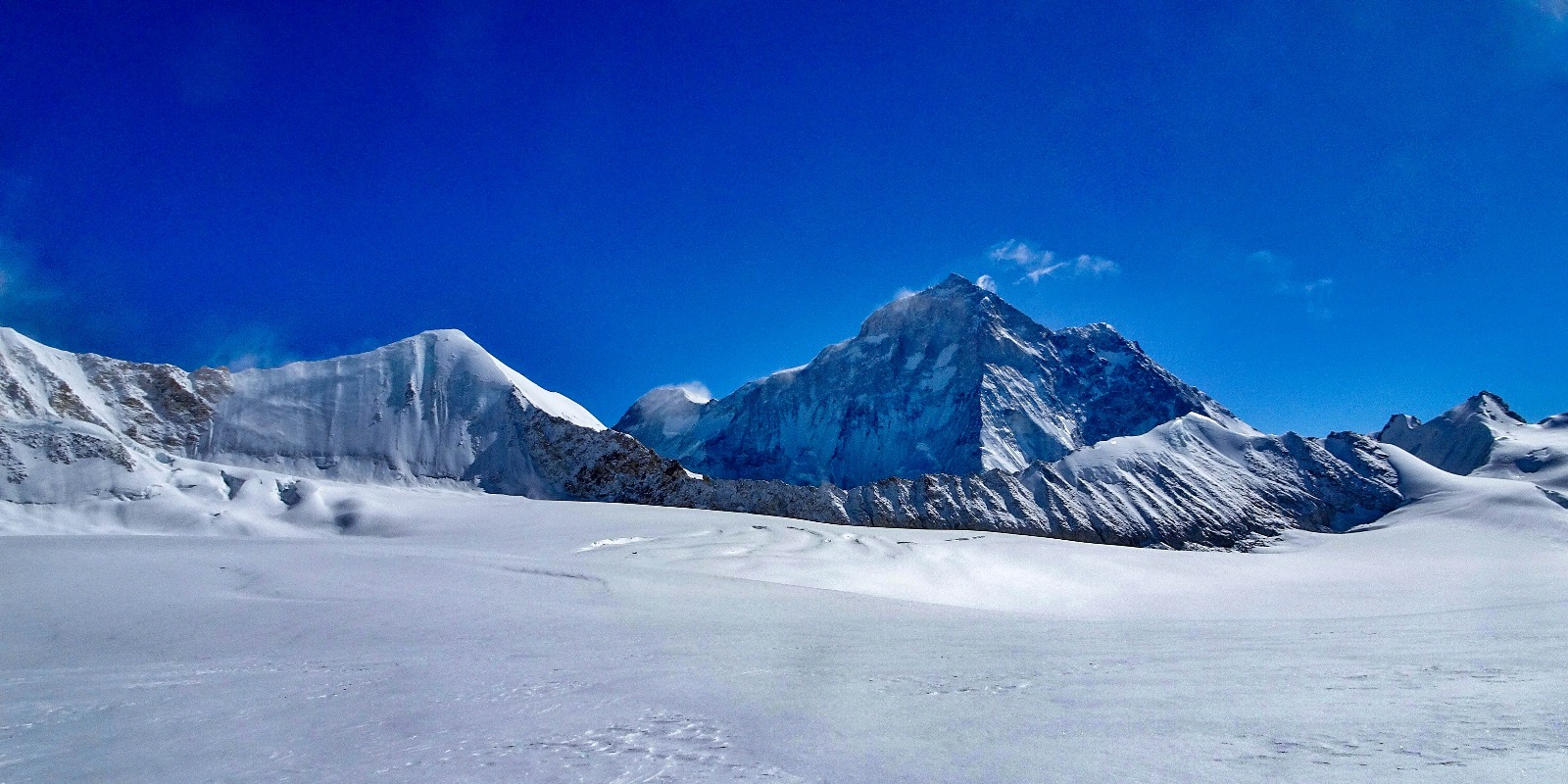
Another reasonably complex pass, Lumbha Sambha, follows Olangchung Gola. Most people camp at a “base camp” and leave before dawn the next morning to cross the saddle of the pass at 5,160m. Expect deep snow and spectacular views of Makalu to the west and Kangchenjunga and Jannu to the east.
Once down from the pass, you’ll hike at a lower altitude for the next few days before gradually climbing toward Makalu Base Camp at 4,870m. From there, it is on to Swiss Base Camp at 5,150m.
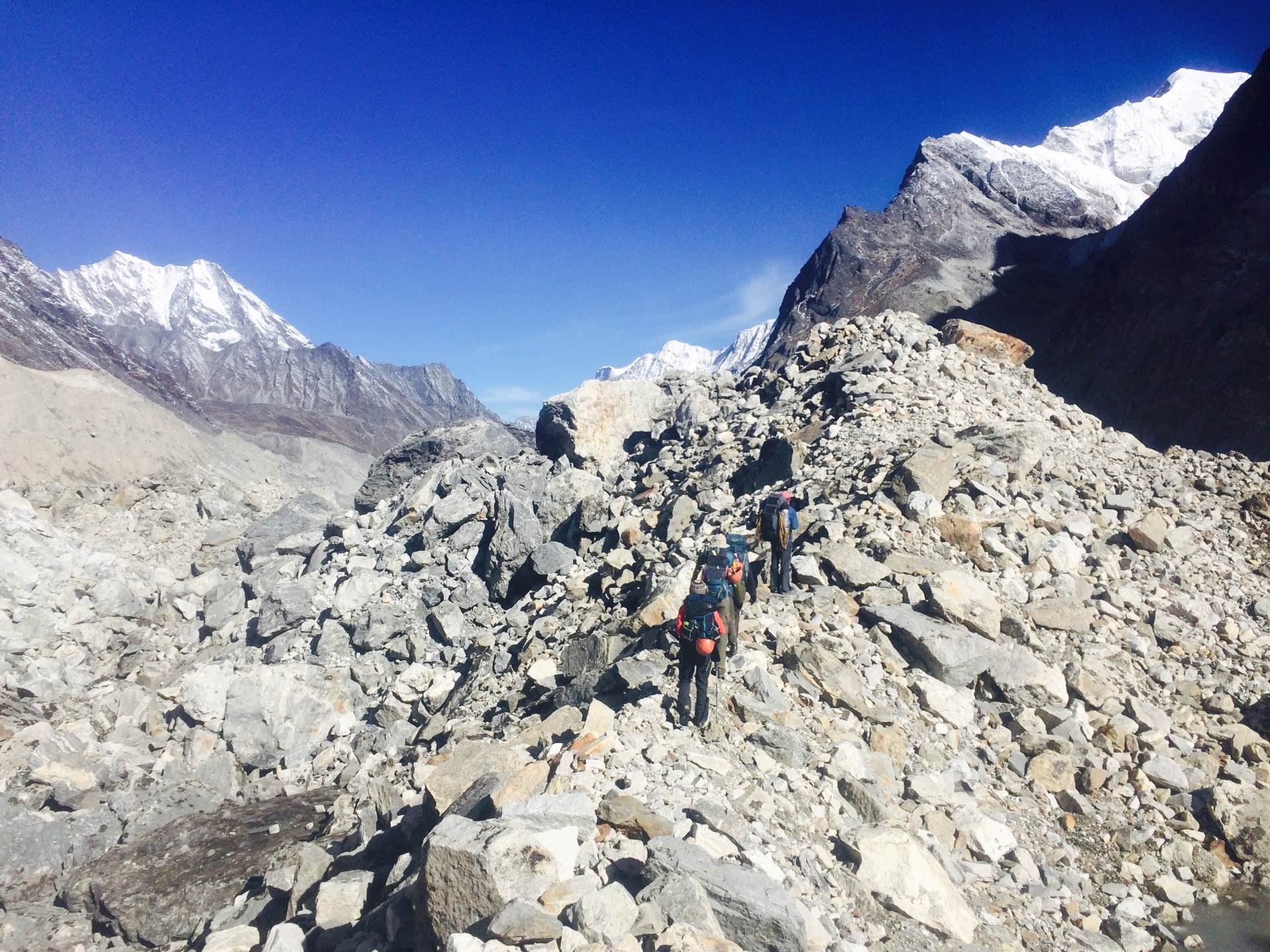
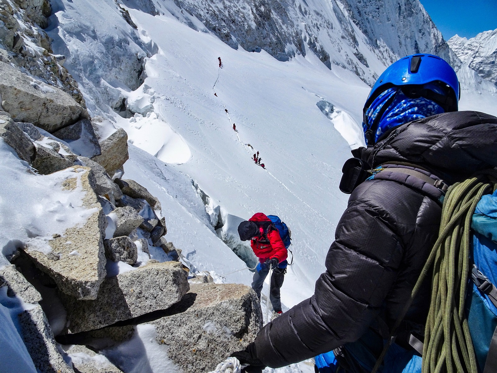
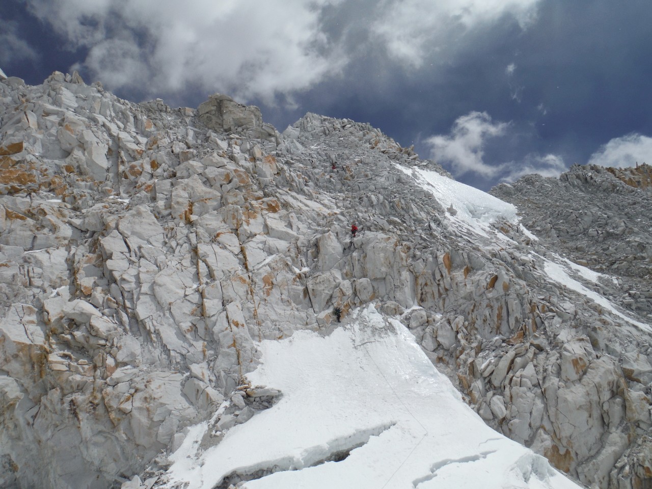
Next comes the crux of the entire traverse: Sherpani Col and West Col.
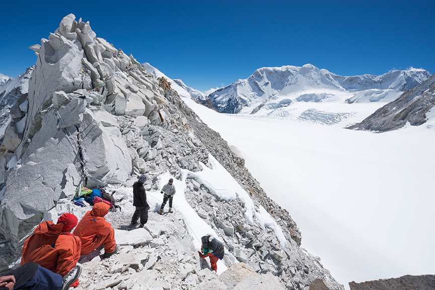
This crossing should not be attempted in poor weather. It’s wise to take a couple of short days on approach to monitor the weather, acclimatize, and prepare your legs. The route requires crampons and ropes. Some sections require rappeling, and basic mountaineering is a plus. Few people cross Sherpani Col unguided.
It’s best to camp close to the pass. Expedition companies typically stay near the glacier's snout at 5,688m, leaving only 500m of altitude gain to Sherpani Col at 6,155m.
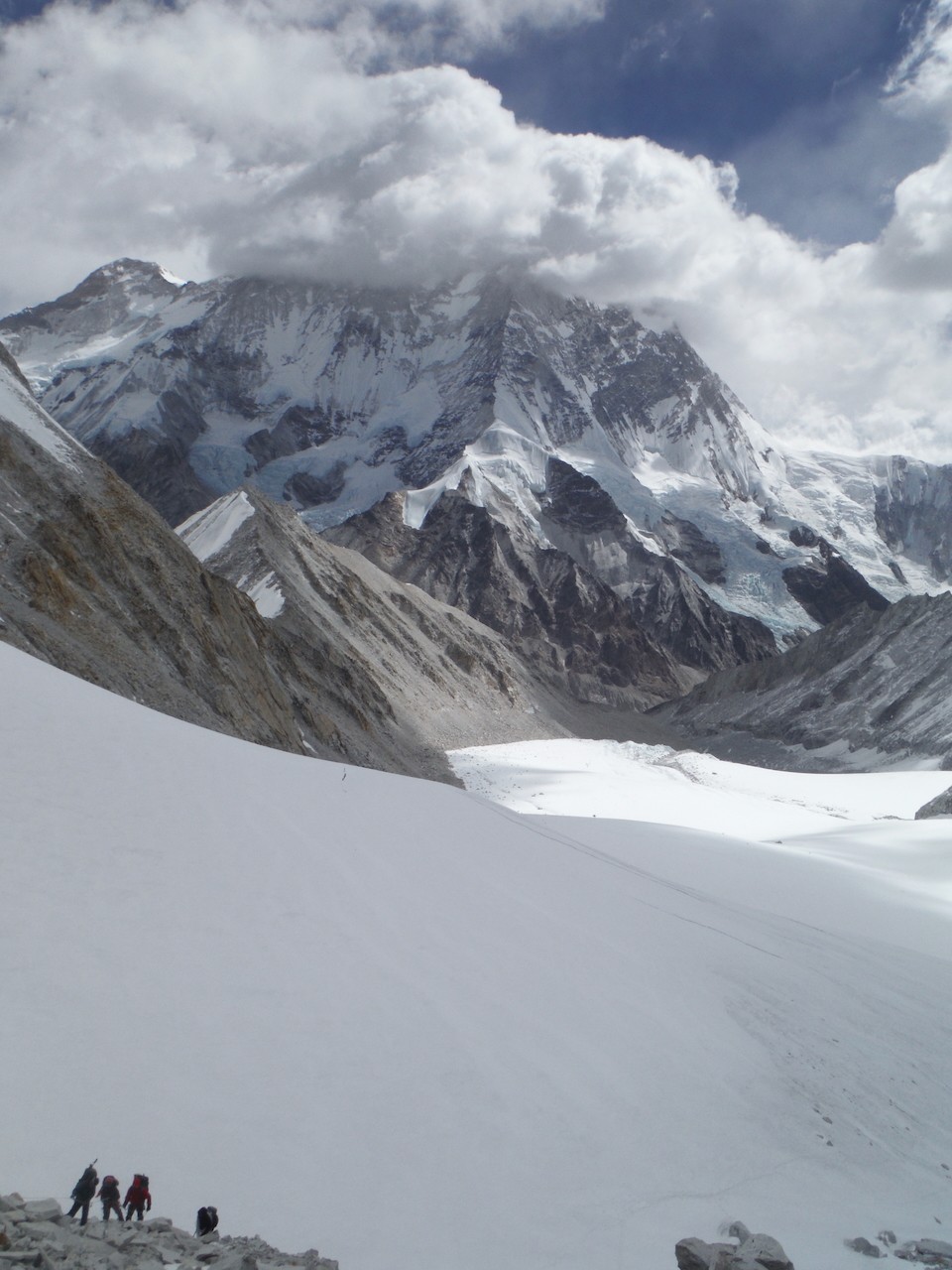
Sherpani Col
The ascent to Sherpani begins on a gentle snow slope but soon transitions to steep, loose rock. Once on the col, it’s a steep descent (with dangerous loose rock) requiring ropes to the flat glacier that links Sherpani and West Col (6,143m). It’s only a couple of kilometers between the cols, but in deep snow above 6,000m, it can be an energy-sapping slog.
Getting across in one day, especially for large guided groups, is rare but not impossible. Heather Hawkins, who trekked the GHT in 2016 as part of a tour, described the crossing as the hardest of her 152 days during the traverse.
“I had worried about this pass before the trip, but it was a fantastic, challenging day. It took 13 hours through deep snow and across hidden crevasse fields, but we crossed in one day. It was hard because of the altitude, and the weather deteriorated toward the end of the day, but by then, we were preparing to camp.”
Conditions are everything, and the earlier in the day you start, the firmer the snow is, and the more likely you are to cross both cols in a day.
World Expeditions, a tour company specializing in the GHT, builds in at least a day of flexibility for the crossing:
“If conditions are favorable, and the group is moving at a good pace, we may attempt both cols in a day. But in all likelihood, we’ll be camping at Baruntse Camp 1 on the West Col at 6,100m on the first night. [We then] descend the col to the Honku Valley the next day.”
The descent from West Col to the Hongku Glacier is not as steep as from Sherpani but still requires fixing ropes. From here, you’ll receive spectacular views of the Khumbu, provided the weather plays ball.
Rappelling down high passes
The next day is more relaxed, hiking across the moraines of the Hongku Basin, but it doesn’t last, the 5,000m+ passes come thick and fast till Rolwaling.
Amphu Labsta, 5,845m, is lower than the cols but a difficult glaciated pass with a narrow, exposed ridgeline. The descent requires fixed lines and rappelling. Hawkins regards this as the most technical section of the trek.
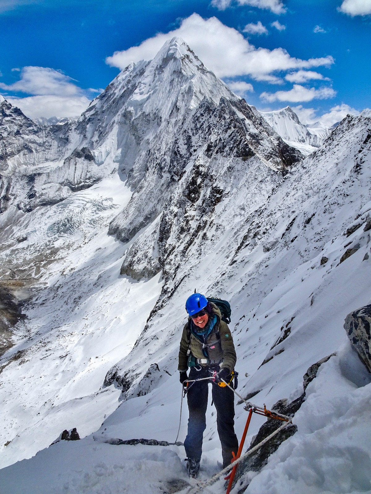
From Amphu Labsta, you descend to Chukung and then Dingboche. After some pretty remote trekking and camping, this is a return to civilization, with tea houses and (likely) many other hikers.
From Dingboche, you scramble up to cross 4,759m Cho La and then descend to the Ngozumba, the longest glacier in Nepal (the Khumbu is the largest). After crossing the glacier, you arrive in picturesque Gokyo. Here, you can take a day hike to Gokyo Ri for perhaps the best view of Everest without climbing a major peak. The trek up is brief but unrelenting, a one to three-hour slog depending on your fitness, ascending from 4,750m to 5,357m.
Whether or not you do Gokyo Ri, you’ll make a steep ascent leaving Gokyo. Renjo La (5,360m) is steep but not difficult in good weather. The descent is via huge stone steps. In good conditions, you can do the pass and descend to the village of Thame (famously, the childhood home of Tenzing Norgay and recently hit by catastrophic floods) in one long day. However, most groups either camp en route or stay in one of the tiny Sherpa villages along the way.
From Thame, there is one final big pass before Rolwaling and an extended period of lower-altitude hiking.
You can read Part II of the Great Himalayan Traverse, covering the route from Rolwaling to the Tibetan border and the differences between guided and unguided hikes, here.
On Jan. 1, 2025, adventurer, writer, and BBC presenter Alice Morrison will set off from the Jordanian border to cross the Kingdom of Saudi Arabia on foot. Expected to take five months over two winters, the north-to-south trek will pass through deserts, mountain ranges, and cultural sites before ending at the Saudi border with Yemen.
Saudi Arabia began issuing tourism visas in 2019, and Morrison jumped at the chance to explore it.
“I have been studying Arabic and the Middle East for 45 years, but Saudi has always
been closed to me. Now, I get to explore the heart of Arabia. I want to get past the politics and meet the people," Morrison said in a press release.
Women-centered adventuring
The politics of Saudi Arabia — and relatively limited opportunities for women in the country — will make for an adventure that explores the social as much as the physical terrain. Morrison will make a point of seeking out Saudi women to interact with. She'll be accompanied at various stages by Princess Abeer Al Saud, racing driver Mashael Obadain, guide Sara Omar, and a group of Saudi's first female wildlife rangers. Morrison is fluent in Arabic.
View this post on Instagram
 Adventurer (@aliceoutthere1)
Due to the extreme temperatures in Saudi Arabia during much of the year, Morrison will split her expedition over two separate winters.
Extensively traveled in the Middle East and North Africa, she has past experience trekking long-distance with camels. She's also cycled the length of Africa and walked across Jordan. Her book Walking with Nomads chronicles the effects of climate change on Saharian nomadic people.
"I am a mid-life woman (61), and I hope my adventure inspires others to get out and follow their dreams. I couldn’t have attempted this at 25; I needed the life experience to get me here," she said.
The Saudi Arabian trek will become a BBC series and a book when she's finished, but she'll certainly be making posts along the way. You can follow along here.
The body of a 27-year-old bushwalker who went missing last week has been found at Tasmania’s Federation Peak. Authorities have not yet released his name.
The man set out to hike the 72km Eastern Arthur Range Traverse last Tuesday. He had intended to finish over the weekend. When there was no word from him by then, a friend raised the alarm on Monday afternoon.
Five ground crews and a helicopter began a three-day search, and one of the ground teams found his body on Wednesday. They spotted a beanie hat, gloves, and backpack rain cover. This led them to the location of the body at the bottom of a cliff face on one of the approaches to Federation Peak. They believe the man perished in a fall.
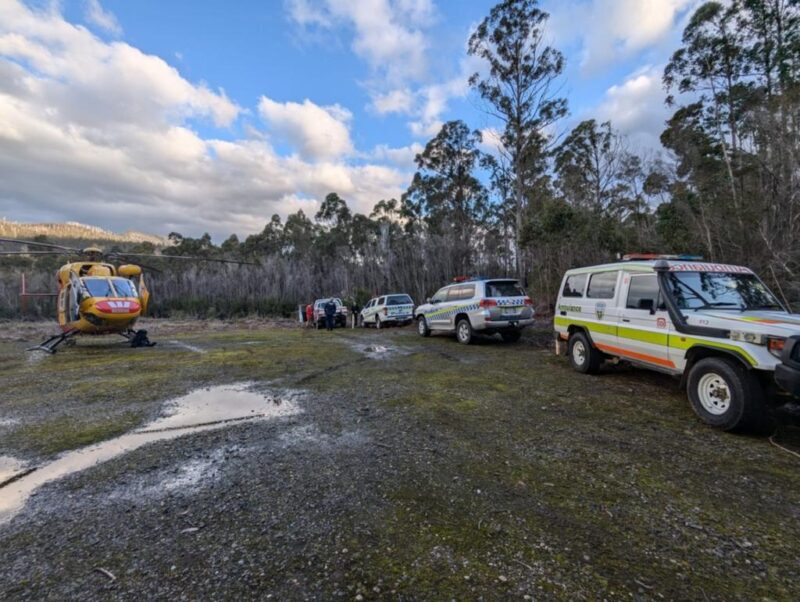
Searchers have not yet managed to retrieve the body because of its difficult location and the high winds, which grounded the helicopter.
The bushwalker was experienced and had a military background but was not carrying a personal locator beacon or satellite phone.
The Eastern Arthur Range Traverse is not an easy route. It usually takes experienced hikers between six and nine days to finish.
“This walk is for physically capable and highly experienced walkers who are confident with navigation, cliffs, and rock scrambling, pack hauling, and extreme weather," said the Tasmanian Parks & Wildlife Service.
Lately, winds in the region have reached up to 100kph, and the rain-slicked trail has made for difficult, even dangerous walking. In the last 10 years, police have made 20 recoveries in the Federation Peak area, including six deaths.
Nicholas Bourne, a British runner who ran the length of Africa 26 years ago, has dismissed the controversy over "Hardest Geezer" Russell Cook. Bourne would like to see Cook celebrated rather than embroiled in a debate over who was first.
Cook, 27, arrived in Tunisia on Sunday after running from the southernmost to the northernmost tip of Africa. On Instagram, the flamboyant runner with the scraggly red beard called himself “the first person to run the full length of Africa.”
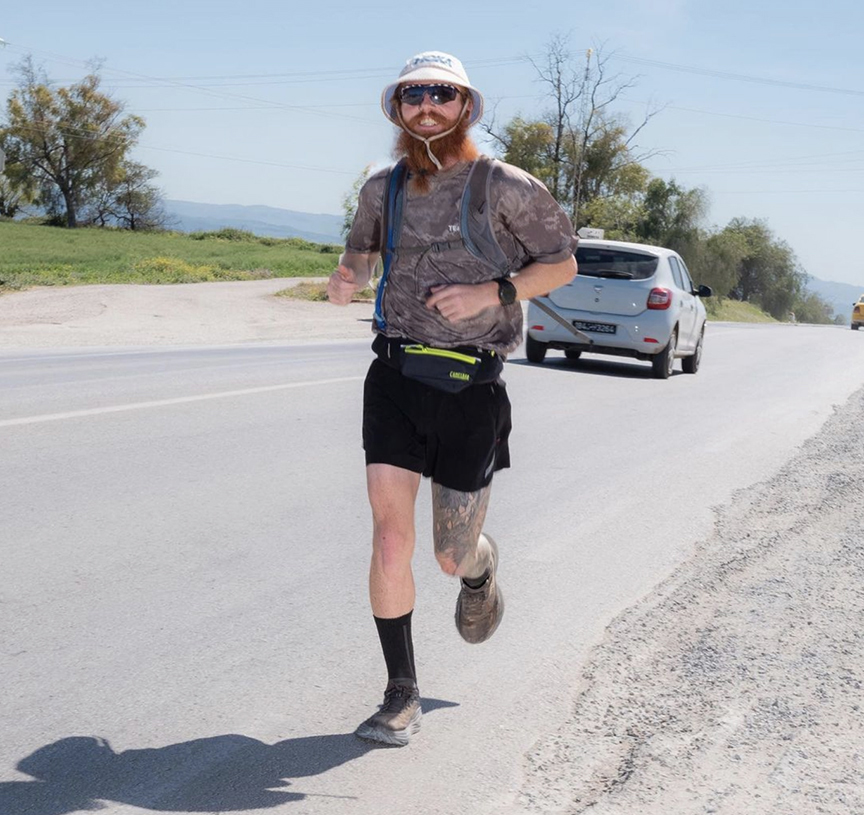
The claim has caused controversy. As he drew near the finish, the World Runners Association (WRA) released a statement saying a Danish man named Jesper Olsen ran from Egypt to South Africa from 2008-2012.
The WRA ratifies around-the-world runs by examining logbooks, data, and GPS to make sure claimants are genuine. It also defines continental crossings. By its standards, ocean to ocean, with a minimum distance of 3,000km, counts as a continental crossing.
Definition dispute
The debate centers around what constitutes the length of Africa.
Some say the length of a continent is a straight line as the crow flies along its longitude or latitude. In Africa, that's 8,000km on a north-south axis.
But Cook’s team defines the “full length” as covering any route between the southern and northern extremes. A huge following defends this common-sense definition.
To add further confusion about who was first, it emerged that another man had run from South Africa to Egypt and was recognized by Guinness World Records. In 1998, Nicholas Bourne, then 28, ran for 10 months and finished by the pyramids in Cairo.
The WRA is preparing a new statement recognizing Bourne as the first. But Bourne himself thinks the controversy is overblown.
“The term 'storm in a teacup' springs to mind," Bourne told ExplorersWeb. "My feelings are congratulations to Russ because what he’s done is absolutely phenomenal. To run that distance and in that time, I have a very good understanding of how hard and difficult it is."
He believes there wouldn’t be this debate if Russ Cook had just claimed that he was the first to run from the southernmost tip to the northernmost tip of Africa, but that is beside the point.
“It’s so difficult with all the things that get thrown at you,” said Bourne, a former model who now runs a sports management agency. "Russell had some incidents of being held up by people with machetes and running through war zones. I totally understand what he's been through."
What's important
Bourne wants people to focus on what's important, such as the $1 million that Cook raised for charity.
The debate has stirred good memories for Bourne. He’s gone through old pictures and reminisced about all the people he met during the adventure.
Bourne went back and cycled the same route in 2015. What struck him most was how the cities had grown since his run in 1998, especially in Kenya.
What does the WRA say?
Marie Leautey is a member of the WRA and ran around the world in 2022. She also commends Cook’s achievement. But she says he is not the first in the WRA’s eyes.
She compares it to running across America. Many runners do different routes, some from San Francisco to New York, others from Los Angeles to Miami. They are all considered running across America.
“If I said I have run from Seattle to New York, it would be self-evident that I have run, in effect, a transcontinental length of the continent,” she said. "And people would not go into the details of where the crow flies, or the length of, the lines of latitude, etc.
“I would struggle to understand why this [would be any different in Africa]," she added. “Because the north-south axis of Africa has been run so few times (three as far as I now know), it would be easy and deceitful to [claim a] 'first in history' for every route a runner takes.”
Along with one distinctive Led Zeppelin song, the ravaging natural beauty of Iceland anchors the country in the popular lexicon. Lava flows, hot springs, glacial expanses, and meltwater lakes — they all proliferate in the land of fire and ice.
It’s become popular for tourists and trekkers alike. But at 500km from east to west, at an arctic latitude, don't expect a casual winter traverse.
Just ask James Aiken, a multi-discipline athlete who recently used every tool in his considerable kit to punch out the challenge safely and rapidly.
Aiken packed a sled with every practical contingency from ski wax to ice axes and planned for 35 days on the 530km hump. When he pulled into Þorlákshöfn, an improvised endpoint due to a hazardous river crossing he encountered midway, he was 14 days ahead of schedule.
View this post on Instagram
“When I finally stashed my pulk to finish the trip, it still weighed 45 kg,” he said. “But it’s like that on a pulk journey. You begin with all the supplies you might need because all you know is that you have to be self-sufficient. What you don’t know is what will happen along the way.”
That can be especially true during winter in Iceland’s exposed highlands. Sudden squalls commonly create whiteouts, and North Atlantic wind can rip across the continent at almost hurricane force.
The terrain itself can also cause havoc. Spindrift makes fragile cornices that overhang countless cliffs in choppy lava fields. Snow bridges often provide the only practical river crossings, and deep snow can make a skier feel like they’re stuck in mashed potatoes.
'Micro-navigation'
Aiken knew all this from one previous experience skiing across Iceland in winter, as part of a team in 2022. He also understood that planning and navigation would be critical. He’s an experienced skier, trekker, surfer, and especially sailor — which gave him a distinct orienteering edge.
View this post on Instagram
“I’ve sailed all my life, so I really love navigation. When I find myself in a semi-mountainous region in a whiteout, and it’s down to compass nav, I feel quite comfortable,” he said.
He explained that the ability to “micro-navigate” efficiently kept him safe and on schedule. Iceland’s compact, varied landscape can make for slow progress no matter what. And when snow cover makes some features obscure or invisible, the demand is much higher.

“A weird skill is looking at a map or chart and...to create a working reference of what the next hour is going to look like, so you’re not getting the map back out every three minutes. That way, you can keep your speed,” Aiken said, adding: “You’re dealing with all these little features in Iceland. So if you’re doing this in a white-out, you could quite easily ski off a five-meter drop.”
'Expensive taxi'
Of course, Aiken didn’t rule out that some emergency could occur. But he wanted to avoid calling in a rescue at all costs.
View this post on Instagram
“Have you ever heard of The Coldest Crossing?” he asked me. “Four young English guys tried to ski across Iceland in winter, and they got rescued three times in two weeks. Unacceptable.”
Averse to endangering others, Aiken sought a stronger solution.
A previous partnership with Arctic Trucks gave him the safety cushion he needed. The company re-engineers 4x4 vehicles to perform in winter. Aiken arranged an option to call in a paid rescue with experienced drivers if he needed it.
"I essentially gave myself a very expensive taxi," he joked. "But it was better than making people risk their lives."
Ambitious but resourceful
It's part of a pattern that proves Aiken's recognition of social value — another faculty he said was key to his success. He kept an open line of communication (mainly via Garmin InReach) to friends at the Iceland Meteorological Office. They helped him corroborate upcoming weather events and even advised him on eruptive conditions at Lake Askja, which lies in the caldera of an active volcano.

“You can’t do these things without local knowledge,” Aiken said.
Not everything went according to plan. Weather and snow conditions a few kilometers from both ends of the trip prevented a full ocean-to-ocean unsupported traverse.
Forty-five-knot winds once broadsided him in his tent. That’s plenty to destroy or carry away equipment, and could be a disaster in a remote area. All Aiken could do was reorient his snow wall and hang on.
Later, he abandoned his original endpoint when a dicey snow bridge made one river crossing too perilous.
View this post on Instagram
For Aiken, the trip constitutes one more step in the right direction. A sensible adventurer, he’s more concerned with longevity than statistics. The joys of the outing revolved around the simplistic charms of life on the trail.
View this post on Instagram
“I want to be ambitious but resourceful at the same time,” Aiken said. “If you just keep pushing yourself a little bit each time, you really move forward. Then in ten years, you’ve achieved quite a lot.”
One American skier is well on his way to finishing what’s arguably Sweden's most famous ski route.
Few set out to cover all 1,300 kilometers of the “White Ribbon" (or "Vita Band" in Swedish), an ambitious enchainment that traces Scandinavia's mountainous backbone.
Chicagoan Elijah Ourth is one contender.

The adventure photographer kicked off his journey in early January, and yesterday reported he’s reached Hemavan — the route’s snowy, spiky 700km halfway point.
Despite stiff challenges from storms and deep drifts, Ourth sounded plucky in an Instagram update. After churning through stubborn powder at 1 kph in Gäddede, he was excited for a pizza-tasting respite.
View this post on Instagram
Notably, Ourth is not tackling the trail in its traditional solo, unsupported style. But a team or group strategy has become more common in recent years.
This approach actually reflects the trail’s genesis in 1997, when Torkel and Annica Idestrom undertook their “Around Sweden expedition.” (Anecdotally, the White Ribbon’s first passage actually happened backwards — from northern Treriksröset, where all three Scandinavian countries meet, to Grövelsjön in the south.)
The route's website counts 97 total White Ribbon finishers since 2010. It hosts an unusually strong contingent this year. Ourth thinks it's a record winter for attempts.
One recent solo, unsupported skier to complete the trip was Sara Wanseth. The former Secretary General of the Scandinavian Outdoor Group knocked out the White Ribbon in 60 days in 2022. As Lundhags reported, she triumphantly posed on the bright yellow pylon of the famous Three Country-Cairn when finished.

Ourth now no doubt anticipates that same validation — but doesn't seem to be in a rush to experience it.
"I’m really looking forward to being even more in the high mountains and above treeline which is the environment I really like, and is super pretty! And it will be fun to get to share some parts with my friends who are along," Ourth told ExplorersWeb.
View this post on Instagram
Emma Schroder, 30, has completed her walk around the coastline of Britain. The entire 6,100km route took her two years and three months.
She initially started in 2020, but a few days later, the UK plunged into its COVID lockdown, so she headed home and waited. In July, 2021, she restarted.
Setting off from Lulworth Cove in Dorset, southwest England, she walked clockwise around country. Her method of staying on track was simple: She always kept the sea on her left.

She immediately regretted her chosen starting point: a steep uphill that led her to some precarious cliffs. But her sense of humor allowed her to make light of difficulties. Moments later, a man walked past her and took the downhill section like a mountain goat, while dressed in a suit and bowler hat. Later, she saw another man sprinting up the cliff and her first thought was, “What a psychopath.” Then she realized that she herself was on the first day of a two-year hike.
Inevitably, the hike included low points. A few weeks in, she drank some suspect stream water, which made her very ill. She had to stop and nap every hour as she slowly made her way across a beach in "the manner of a particularly lethargic snail.”
Six times she burst into tears while walking, but later realized that she was just hungry. Another time, she tried to take a shortcut and ended up adding 11 extra kilometers to her day. She ended up in tears three more times when she got lost, and then chastised herself for somehow messing up her "keep the sea on your left" rule.

A two-year walk also brought with it everything the British weather has to offer, from storms and seemingly endless rain to blistering summer heat. In 2022, there was so much rain that her constantly wet feet began to develop trenchfoot.
As a solo woman, she also had to consider her safety. At times, wild camping gave Schroder the willies, as her imagination ran wild. A sudden breeze sounded like someone touching her tent and any rustling outside became a potential axe-murderer. It pushed her out of her comfort zone and showed her courage and resilience that she didn’t know she had.
The aim of the walk was not to complete it as quickly as she possibly could. In fact, she admits she actually walked quite slowly.
“I have also now completed my Lands End to John O'Groats walk in record time -- maybe the longest anybody's ever taken to do such a walk,” she joked when she reached the northern tip of the UK.

She found a lot of joy in simple things -- coastal landscapes, people on the beach, kind offers from strangers. Usually, she camped, so she welcomed the occasional bed.
Schroder carried everything she needed with her, resupplying along the way. Her backpack generally weighed around 15kg. Most of the walk was solo, although friends and family joined her for sections. At other points, she met others who were trekking the coastal pathways and walked with them. One particularly kindred spirit was Juls Stodel, who recently completed her own walk around every bothy in the UK.
When she finally finished on Oct. 8, she admitted, “It's been the hardest but most rewarding thing I've ever done.” Yet she is already planning her next trip, and the possibilities seem endless.
Her jaunty website -- cheekily entitled mylegshurt.co.uk -- lists a few good-humored highlights from the trek:

The Nepal Tourism Board's vague announcement banning independent trekkers has brought confusion and anxiety to international outfitters and especially to would-be hikers getting ready to fly to Nepal.
There is uncertainty about whether the measure applies only to solo trekkers or also to independent (non-guided) tourists in groups of two or more. And to what extent will the Khumbu region possibly skirt this mandate?
Below, we try to provide some answers for those intending to visit Nepal after April 1.

The official document
First, here is the official document from Nepal Tourism Board (NTB):

What does it mean?
- As stated, note that the measure applies to ALL independent trekkers, not just solitary individuals. Any foreign trekker has to hire a guide in order to hike the "protected mountain areas" of Nepal. These areas would include several national parks such as Sagarmatha National Park, Langtang NP, Shey Phoksundo NP, and Makalu Barun NP, and Conservation Areas such as Annapurna's, Kangchenjunga's, Manaslu's, Api-Nampa's and Gauriskankar's. Here is a list of all protected areas of Nepal, including its lakes, hills, historical sites, and wildlife sanctuaries.
- The guide's services must be arranged through "authorized trekking agencies registered with the government of Nepal". That specification requires caution by those hoping to obtain the TIMS card first, then find a private guide, hoping to save some money. Official agencies will take care of everything, including the TIMS card, but at a higher price. Sources from NTB estimate that a guide changes $25 to $50 a day, but possibly much more for longer treks. That amount may be unaffordable for visitors on a shoestring budget. Group fees vary, depending on the trek. The popular Annapurna circuit costs from $850 to $1,100 for those joining a group guided by a local agency. If an individual trekker, a couple, or a small group hires a private guide, the fee is likely higher.
- Not surprisingly, the fee for the TIMS card has doubled. Now, it is 1,000 Nepal rupees for SAARC citizens (residents of South East Asia), and 2,000 rupees for the rest (except for diplomats, who are exempt from payment).
- Authorities justify the new restriction as a safety measure, but there is no mention of how this improves safety. In recent days, NTB members noted some incidents suffered by independent trekkers in the past that could lead to a "misperception" of Nepal as unsafe. However, it seems pretty obvious that the measure, agreed on with local operators and unions, is mainly to increase revenue.
- NTB promises to provide further details "shortly," but it is already rather late. Most trekkers planning to go to Nepal this spring have already bought their plane tickets. Some of them are on a tight budget. Those who are still uncommitted might discard Nepal in favor of other destinations where they can explore freely.
How about the Everest region?
Dawa Steven Sherpa of Asian Trekking told ExplorersWeb that the Khumbu Valley remains unaffected. Home to some of the most stunning mountain scenery in the Himalaya, including Everest and Ama Dablam, the municipality doesn't require TIMS cards. Instead, it levies a regional fee, to be paid on arrival in Lukla and combined with the entrance fee to Sagarmatha National Park.

Billi Bierling of The Himalayan Database is unsure whether this Everest exemption will continue in the future. "It was like that until last year, but I am not sure how the new regulations will apply," she said. "You never know in Nepal."
To learn more, ExplorersWeb asked some Sherpa mayors in the Khumbu.
"Individual tourists are heartily welcome and free to travel in the Khumbu region," Laxman Adhikari, ward chairperson of the Khumbu Municipality, told us. "All they have to pay is 2,000 rupees for a municipality-managed Trek Card, and 3,000 rupees to trek in Sagarmatha National Park."
The Khumbu Trek Card, a local version of the TIMS card, began last year. Issued by the Pasanglhamu Rural Municipality, it is mandatory for all foreign trekkers. Sagarmatha National Park requires another fee for entry.
These do not require visitors to be accompanied by a guide, in part because the Trek Card has a tracking system. The Khumbu region is one of the most popular in Nepal. Its many routes include the trail to Everest Base Camp and the Kala Pattar. The path to Gokyo Lakes, at the foot of Cho Oyu's south side, en route to the coveted Three Passes trek is also in this part of Nepal.

Reactions
The Trekking Agencies Association of Nepal (TAAN) has applauded the measure, but among stakeholders and trekkers, opinions are not so enthusiastic. Many point out that trekking is free in most other mountain areas of the world. Others believe that self-sufficiency is at the core of the trekking experience and do not wish to be guided around.
Some recall is not the first time Nepal has foisted peculiar new rules without warning shortly before the beginning of the spring season. A few years ago, it suddenly became forbidden to photograph members of other mountain expeditions.

"Don't push it," The Kathmandu Post headlines an op-ed piece. It advocates letting visitors decide whether they want a guide or not.
"Nepal has long been touted as one of the cheaper adventure destinations in Asia, yet it is getting costly, even by South Asian standards," the paper wrote. "Time may thus have come to rethink how the country projects its image as a tourist destination [but] we cannot chop and change our rules for incoming tourists without having a long-term vision for Nepali tourism."
As 2022 dawned, more than 100,000 Russian troops were stationed on three sides of Ukraine. Russian escalation in the long-running conflict with Ukraine seemed imminent, although many thought that Vladimir Putin was saber-rattling. Then on February 24, Russian troops descended on the country.
Against the buildup to this chaos, a young Ukrainian soldier, Alina Kosovska, had planned a long wilderness trek in the dead of winter. On January 8, Kosovska set off from the village of Velyky Berezny, in northern Ukraine. On her back was a hefty pack, stuffed to the brim with food and gear. Ahead lay over a month of solo hiking in midwinter on Ukraine's Transcarpathian Route. A 400km trail that takes the highest and most challenging sections of the Carpathian Mountains that lie within Ukraine.

A lesser-known trail
Unlike established trails such as the Appalachian Trail in the United States, the Transcarpathian Route is underdeveloped, with few outside visitors. Although not brimming with technical peaks, the route is wild, remote, and a significant challenge for a solo hiker in winter.
Undeterred, Kosovska, whipped herself into shape by running marathons. She also tested her key pieces of equipment in winter conditions, where reliability matters far more than during warmer seasons.

The Ukrainian soldier donned snowshoes and initially headed north, before looping south in the direction of the Romanian border. The burden of a heavy pack worsened when snow conditions became tricky. In the deep, soft forest snow, Kosovska found the going tough. She slowed down to less than 1 kph in places.
"There is a lot of snow there," she said. "It is not covered with an ice crust and it is difficult and long to walk on it, especially uphill."

Pushing through the slow days
At ExplorersWeb we cover a whole range of winter expeditions, from Antarctic sledding to winter treks in North America. When the pace slows and days of slogging through deep snow pile up, the only thing to do is to grind on. Quite often, we see adventurers fail, sometimes through a lack of experience in these conditions, and other times due to an unwillingness to ride out the monotony.
Kosovska's average pace was 1.5kph, and her longest day was 12 hours. Undeterred the Ukrainian soldier pushed on without faltering.

Every 20 to 60km, Kosovska had the opportunity to restock her mobile pantry at villages en route, although this depended on the area. On one section through the Chornohora range, which included climbing Hoverla, Ukraine’s highest peak (2,061m), the determined mountaineer had to push 100km without resupply.
“It is the most difficult because you have to walk almost 100km carrying all food, fuel, and supplies.”

Dropping off medical supplies
As well as collecting supplies, Kosovska made use of shepherd huts as a break from camping. There are typically three types of huts in the Ukrainian mountains: kolybas, where cheese dairies operate in summer, hunting cabins, and tourist shelters.
As in many parts of the world, there is a tradition to leave dry firewood, supplies, and medicine for future travelers. Kosovska took it upon herself to leave first aid kits in each of the huts she visited.

Few people are known to have attempted this route in winter, and these attempts are not well documented. Although navigational markings are reasonable in summer, the route Kosovska followed is less clear under a winter blanket. This also makes it more technically challenging.
However, Kosovska is the director of a charitable foundation and volunteer mountaineering group and guides tourists in the Carpathians when on military leave. This experience of the same mountains in summer no doubt helped her through the trickier sections.

A return to service
After 37 days of snowshoeing, covering some 400km, Kosovska arrived at the end of the trail in Dilove, near the Romanian border. It was February 14, just 10 days before the invasion. She had just completed the first known winter crossing of Ukraine’s Transcarpathian Route. She did it the hard way -- solo, in the coldest months, and against the backdrop of war.

Since finishing the trek, Kosovska resumed her military role as a drone operator in aerial reconnaissance.
Despite some leave to guide in the mountains in the past month, she will be heading back to the front lines in January. "I have been doing this since 2015 and will continue to do it as long as necessary," says the resolute young Ukrainian.

On Friday, March 11, 2022, winter explorer Emily Ford and Diggins — a retired sled dog and her adventure companion — pulled the plug on the final days of their 320km ski trek along the Minnesota-Ontario border.
They had fewer than 50km to go and were just two days out from the intended endpoint of Grand Portage, the area where several streams coalesce into Lake Superior.
Open water
The Duluth native explained that she had initially planned to reach Grand Portage by skiing the Pigeon River, which began near the trip's 270km mark. But when she and Diggins arrived at Pigeon River's banks, they found it "open and flowing" — it was thoroughly intractable.
Ford signed off on the trip without any palpable regrets:
This was a fantastic trip. I did what I set out to do: traverse the Boundary Waters by ski and paw. I am so incredibly proud of myself and Diggins! We saw one of the most spectacular places in one of the most spectacular seasons. No. We lived in it!
The Duluth native is a passionate advocate for, in her words, "getting kiddos into the outdoors". She uses her expeditions to fundraise for children's wilderness trips.
The adventures of Emily Ford & Diggins
Ford and Diggins's 28-day tour began on February 11 in Crane Lake, Minnesota. It was the duo's second epic winter trek in less than a year. The plan was to ski, skijor, and snowshoe from northwestern Minnesota across the Boundary Waters Canoe Area Wilderness (BWCAW) to Lake Superior, at the state's northeastern tip.
Their first expedition, and the one that put Ford's name on the adventure map, followed the 1,900km Ice Age Trail in Wisconsin. Because of its length and remoteness, the Ice Age Trail rarely sees a complete thru-hike even in summer. Ford is only the second person to walk the Ice Age Trail's entire length in winter.
Breaking Trail is a short film about Emily Ford and Diggins's 2021 expedition that premiered at the Banff Film Festival last November. The documentary is available to stream (for a small fee) through The Banff Centre and will show at select venues throughout 2022 as part of the Banff Festival's World Tour.
Most long-distance hikers are familiar with the thru-hiking Triple Crown of the United States’ Appalachian Trail (AT), Continental Divide Trail (CDT), and Pacific Crest Trail (PCT). But while thru-hiking continues to gain traction in the U.S. and Canada, the countries’ North American neighbor has lagged behind.
Both the Continental Divide and Pacific Crest trails have a terminus at the Mexican border. Mexico itself, however, has no thru-hiking scene to speak of.
One woman is looking to change that.
Mexican thru-hiker Zelzin Aketzalli completed the Triple Crown in 2019 on the CDT. In April of that year, she started it at a unique place, with a unique idea in mind — to see if she could extend it into Mexico.

Route research: Continuing the CDT in Mexico?
Aketzalli’s CDT thru-hike started 136km south of the U.S. border, in the Mexican state of Chihuahua.
“I started there because I wanted to see if it was possible to continue the route along the Continental Divide through Mexico and then connect to the Continental Divide Trail in the United States,” she told christiancentury.org. “I got a taste of what a Mexican portion of the CDT would be like.”

Quickly, though, she realized that northern Chihuahua was too dangerous for thru-hikers, so she shifted her focus to Baja California.
The long, narrow peninsula is already home to the world-famous Baja 1000 off-road race. Aketzalli saw hiking potential in it, though, based on an ancient missionary route.
The Camino Real: Aketzalli seeks to build a path along this ancient conduit
Catholic Jesuits oversaw the construction of the Camino Real from 1697-1768. The trail connects Loreto at the southern end of the peninsula with El Descanso in the north. Road construction and erosion have significantly blurred the original route, but much of it is still visible.
Aketzalli said research for a thru-hike based on the Camino Real is “almost finished”, but that significant obstacles still lie ahead. Routefinding challenges like avoiding roads while stringing water sources together stand in the way, as do bureaucratic roadblocks.
The project would be the first of its kind in Mexico, where Aketzalli says that thru-hiking is all but nonexistent.
“No one even knows what it is; it doesn’t really exist in Mexico as a sport or as a concept. That’s why education and promotion are my first challenges and objectives in Mexico,” she said. “I think the biggest obstacle will be introducing the people of Mexico to this type of sport. Another is getting support from the government for these kinds of trails.”

She also hopes the possible 1,100km route will focus attention toward the environment and empower Indigenous communities by economic proxy. For her, thru-hiking is a spiritual undertaking. She hopes that her work can help other Mexicans feel the same way.
“I have had many spiritual experiences on my hikes. For the Nahua people of Mexico, Mother Earth is called Tonantzin. She takes care of you because you take care of her,” Aketzalli explained. “Walking the Camino Real offers us a chance to explore and better understand our relationship to our land and history.”
You can follow Zelzin Aketzalli on Instagram.
As borders reopen, long-distance cycling has become more popular than ever. It's low cost, eco-friendly, and allows you to go almost anywhere -- even Antarctica.
ExplorersWeb has rounded up six exciting long-distance bike tours happening right now. Some of the cyclists are athletes. Others are relatively new to life on two wheels. Their expeditions range from round-the-world marathons to extreme Arctic adventures.

Arctic World Tour
Italian cyclist Omar Di Felice started his journey on February 2. He is cycling 4,000km through eight arctic regions. Di Felice began with the first winter bike crossing of Kamchatka, the wild peninsula in the Russian Far East. He covered that 740km in five days.
Next, he is cycling 1,200km from Murmansk, Russia through Finland and Sweden to Tromsø in northern Norway. That section is already underway. On February 14, he crossed into Finland.
From Tromsø, he will cycle short sections in Iceland and Greenland before shifting to Western Canada. From there, he will cycle to Alaska.
Siberia 105°
Stefano Gregoretti and Dino Lanzaretti began a 2,000km expedition through Siberia on January 13. First up, an ambitious 1,200km ride from Oymyakon to Verkhoyansk. These two villages are the two coldest settlements in the world.
But after just 620km, they aborted on February 4. The duo had struggled from the start. In the first few days, they had problems with the gearboxes on the bikes. Then strong winds forced them to push their bikes, even downhill. It's unclear whether that was because of the strength of the wind or the ungodly wind chill.
Their only options were to abort or to wait out the weather, but their one-month Russian visas would expire before they could complete a postponed expedition. They chose to abort.

Chains and Chords
Louisa Hamelbeck of Germany and her American boyfriend Tobi Nickel are making their way “around the world with bikes and a guitar”.
They left Salzberg, Austria last June and plan to cycle for the next two to three years. Since setting off, they have pedaled through Austria, Slovenia, Croatia, Montenegro, Albania, Greece, and Turkey. From Turkey, they flew to Florida and have now reached New Mexico.

It took them 82 days to travel the 3,250km to their first big milestone: Artemida, near Athens, where Tobi’s father lives. Here, they spent six weeks seeing friends, researching the next few sections of their route, and servicing their bikes.
They wanted to go to the U.S. by boat but they are traveling on the cheap. They found it impossible to find an affordable ship that would take their bikes. In the end, they cycled to Turkey and flew to Miami on December 9.
Explore for Huntington
Dimitri Poffé is biking 15,000km across Central and South America. As the title of his project suggests, he is doing this to raise awareness of Huntington’s disease, for which he tested positive three years ago. Unfortunately, the disease runs in Poffé's family: His sister has had it for eight years, and he lost his father to it 15 years ago.
Currently, he is asymptomatic but he knows that he will develop symptoms between 35 and 40. The diagnosis “was a trigger to realize a dream: to go around the world.” He has chosen Central and South America because the disease most affects that region of the world.

Poffé set off on October 3 from Mexico City. He plans to pass through Guatemala, El Salvador, Nicaragua, Costa Rica, and Panama before cycling through South America.
He reached Guatemala on January 20 and has spent a month exploring the country on two wheels. His next stop is El Salvador.
Migratory Bikes
Camille Pages and Antoine Jouvenel are cycling from the south of France to Nepal. Carrying 40kg each, the French duo will cross 19 countries and cover 20,000km.
Both were relatively new to cycling when they started planning their expedition. They quickly realized that they had a lot to learn.

After a COVID delay, they began their “cyclo-nomadic adventure” in July 2021. Nine days later, they reached Italy. Here the inexperienced pair faced some of their most challenging routes, including Izoard Pass (made famous by the Tour de France) and the Dolomites.
So far they have cycled through France, Italy, Slovenia, Croatia, Bosnia and Herzegovina, Montenegro, and Albania.
Voies Recyclables
Brewenn Helary and Lea Schiettecatte want to complete a zero waste, zero carbon, trip around Europe. Voies recyclables translates to ‘recyclable paths’.
Their circumnavigation of Europe will cover 15,000km. They set off on February 12 from their hometown of Iffendic, in France. Their round-Europe trip will take them through 20 countries.

Since the pandemic, four long-distance hiking trails have opened around the world. They all differ in distance and difficulty but are ideal for working off your shutdown restlessness.
The Red Sea Mountain Trail: Egypt
The Red Sea Mountain Trail (RSMT) opened in 2019. At 170km, it is mainland Egypt's first long-distance hiking trail. For the gateway beach resort town of Hurghada, the trail is also a community tourism initiative that aims to preserve the endangered Bedouin culture.
The RSMT is a network of ancient routes that the Bedouin have used for centuries. The Khushmaan clan of the Maaza, Egypt’s largest Bedouin tribe, manages it.
“We want the Red Sea Mountain Trail to diversify Hurghada’s tourism and create a space for slow, immersive travel in which the Bedouin can communicate their rich knowledge of their homeland to outsiders,” Ben Hoffler, one of the founders of the trail, told Afar magazine.

Completing the full 170km would take most hikers 10 days. The trail is so new that currently, no hiker has completed the full distance. Though many would see 15-20km a day as a manageable distance, the walk is not easy. There is not a well-trodden path to follow, there is considerable elevation gain, and some sections require exposed scrambling.
Everyone who wishes to tackle the trail must do so with Bedouin guides. For centuries, these nomadic desert tribes have been the only people to walk through these mountains. The guides aim to show visitors the “wisdom and beauty of Bedouin heritage”.

This month sees the first-ever group trying to complete the full thru-hike. So far people have only completed smaller sections. For those who don’t have 10 days to spare, or who want a less demanding trail, you can choose shorter, flatter guidedcircuits.
The founders of the trail have also created supplementary ‘hiking hubs’. Each hub consists of a web of secondary routes that fork off of the main trail, and centers around a specific mountain massif.
The six hubs can add a further 600km to the journey. The Red Sea Mountain Trail Association is already exploring the idea of expanding the main path into a 1,000km route that follows the Red Sea and provides economic support for other clans and tribes.
The Michinoku Coastal Trail: Japan
In March 2011, a 9.0 magnitude earthquake and tsunami ravaged the northeast coast of Japan. It is the fourth largest earthquake since records began in 1900 and it claimed over 18,000 lives.
In the decade since, Japan has been rebuilding its communities, but one initiative in the Tohoku region has gone relatively unnoticed. Among all the reconstruction, they have also built a new hiking trail.

The Michinoku Coastal Trail (MCT) stretches for 1,000km along Tohoku’s eastern coastline. Michinoku is the ancient name of the Tohoku area. Officials hope that the trail will increase tourism in the little-known area and help with the region's long-term recovery.

The MCT officially opened in June 2019 but it remains relatively untouched because of COVID travel restrictions. The route connects Hachinohe in Aomori Prefecture with Soma in the Fukushima Prefecture.
This off-the-beaten-track route “follows the Pacific Ocean coast over grassy promenades, through forests, along remote beaches and soaring clifftops and to fishing ports, some tiny with a few one-man boats and others with fleets of ocean-going trawlers," Paul Christie from Walk Japan told the BBC.

Completing the full trail takes anywhere from 6 to 12 weeks. Those daunted by the prospect of a three-month trek can do smaller sections. The route runs through four prefectures of Japan: Amori, Iwate, Miyagi, and Fukushima.
The Michinoku Coastal Trail website breaks these down even further into 28 smaller hikes. It explains which ones are best for newbies, and which are more challenging.
Grampians Peak Trail: Australia
The Grampians Peak Trail runs 160km through Grampians National Park in Victoria, Australia, from Mount Zero in the north to Dunkfield in the south. The Victoria government bills it as a “challenging" 13-day hike.
The trail traverses several mountains and bypasses waterfalls, sandstone rock formations, grasslands, ravines, and eucalyptus forests. Some of the highlights include the Grand Canyon, the Major Mitchell Plateau, and the summits of Mt. Difficult, Mt. Abrupt, and Mt. Sturgeon.

Even though you summit several mountains, the trail was not built as a sporting route or place to see who can complete it the fastest.
Known as Gariwerd to the Djab Wurrung and Jardwadjali, who have lived here for over 22,000 years, the Grampians feature aboriginal rock art, as well as abundant wildlife -- 40 different mammals, 28 reptiles, and countless birds. There are also over 1,000 plant species, including 130 types of orchids.

Navigation is tricky. The route crosses large rocky expanses without a worn trail to show the way, only sporadic yellow markers.
After a decade of work and a cost of $33.2 million, the GPT finally opened in November 2021. Eleven new campsites, deep within the park, offer simple amenities. Water is available either at these campsites or at designated nodes, identified on the trail website.
The Walk of Peace: Slovenia and Italy
The Walk of Peace trail stretches 270km from the Alps to the Adriatic Sea, along the World War I front line between Slovenia and Italy.

The Walk of Peace opened in April 2020 and follows the Isonzo Front, which saw 12 battles between Italy and the Austro-Hungarian Empire from 1915 to 1917. Over 350,000 soldiers died here. The trail aims to restore the historical sites in the region.
In part, the trail is a history lesson for active students. Mountains and rivers compete with museums and memorials that give trekkers insight into what the region endured during World War I.

The Walk of Peace begins in Triglav National Park. From here, hikers follow the Soča River through Solvenia’s wine country. Leaving Brda, the trail meanders through the Karst region before descending toward the Adriatic. The endpoint is Trieste, Italy.
The main trail splits into 15 one-day sections and is accessible for hikers of varying abilities. Two further trails and a myriad of smaller paths branch off from the main route. One subtrail leads to Kranjska Gora, a winter sports hotspot. The second ends at the town of Bohinjska Bistrica. Smaller paths loop to historical sites.

Throughout the walk, peace and natural beauty contrast with the setting for wars fomented by kings, politicians, and their generals.
The Island Walk: Canada
Prince Edward Island is Canada's smallest province, but that doesn't mean it's short on attractions. Cradled in the Gulf of St. Lawrence by New Brunswick and Nova Scotia, it's famous for its red soil, beaches, and seafood.

It's also the fictional home of Anne of Green Gables and produces outstanding potato crops.
Now, it features the country's newest hiking trail. The 700km Island Walk spans the picturesque island's entire perimeter in 32 sections. Hikers can finish it in a month of longish day hikes.

Along the way, inland and coastal passages reveal beaches, farmland, intermingled hardwood and softwood forests, and cozy towns. The scenic highlights look like they're ripped right out of a coffee table book.

Partnering inns and hotels along the way help travelers with various logistics like luggage transfer services and kitchen access.

Hiking the trail requires notably minimal equipment -- basically, a day pack and a comfortable pair of shoes. Bicycle rental services are also available.
The Island Walk season generally starts in May and ends in October. July and August are heavy tourist months on Prince Edward Island, so note that accommodations might be in peak demand at that time.
The trail officially opened in November 2021. For more information, including FAQs and a section-by-section breakdown, go to theislandwalk.ca.
On February 2, ultra-distance Italian cyclist Omar Di Felice hopped on his bike to start a long, cold ride.
In total, Di Felice's westbound route will cover 4,000km of arctic terrain, from Kamchatka to Alaska. His Arctic World Tour will include stages in Scandinavia, Iceland, and Greenland. He hopes to inspire people to travel by bicycle and point out the impact of fossil fuel emissions on arctic landscapes.
Di Felice's route and trip details
Di Felice hopes to complete the cycling in three weeks. Currently, GPS tracking shows that he's already covered a good chunk of the 800km he planned to ride between the capital of Petropavlovsk-Kamchatskiy and Ust'-Kamchatsk.
He will then proceed to Murmansk, Russia, near the Norwegian border. Stages between Tromsø, Norway, through Finland and Sweden, will take him another 1,500km. Di Felice will then go island-hopping; short stages in Svalbard, Iceland, and Greenland follow.
Finally, he will travel (by some means other than cycling) to Whitehorse, Canada, for a long final stage ending at the Yukon-Kuskokwim Delta in Alaska.

Di Felice has a specially-outfitted touring bike to crunch through the snow. Along with his 4,000km on the bike, he's imposing a rule to supply and support himself locally when possible. Even if it's well below zero, he plans to pitch camp if he can't find indoor accommodation.
You can follow Di Felice via social media channels. He plans frequent updates, with episodes featuring locals and arctic scientists. The ultra-cyclist wants to highlight his interview subjects' experience living in areas under changing climatic circumstances.
Di Felice has previous experience with cold-weather cycling. He already circumnavigated Iceland this winter via the 1,294km Ring Road. The trip took him 19 days.
One year ago, 10 elite Nepali climbers raced for and made the first winter ascent of K2. This year, the game will be less epic, but even more dangerous than K2: climb Cho Oyu in winter from the Nepal side. And now a second team has joined the fray.
Led by Pioneer Expedition's Mingma Dorchi Sherpa, the new team is heading to Cho Oyu's south side with the same goal as the expedition led by Gelje Sherpa: to open a new route for commercial climbs.
Competitors

Mingma Dorchi confirmed to Stefan Nestler that both teams will climb separately, although he was willing to collaborate with Gelje's team on the last stage of the climb.
There can be only one commercial route
This final teamwork may or may not happen, but the commercial race will be anything but peaceful. Pioneer Expedition is a thriving local outfitter, eager to recover the market share it lost when one of its key figures, Lakpa Sherpa, left to form his own company, 8K Expeditions, last year.
Gelje Sherpa's venture began as a personal project, supported by donors through a GoFundMe account. It has since come under the wing of Nirmal Purja, owner of Elite Exped, which is now the expedition's main sponsor.

This time, the prize is not so much the summit but rather a viable route, capable of fixing from bottom to top. They also need locations for higher camps where they can stock supplies and oxygen and bring clients with no technical alpine knowledge. The team that opens the route will likely fix the ropes for all expeditions visiting the mountain during peak season. That company will also gain prestige with potential consumers.
The race may be on, but as always, the mountain will have the last word. The South Face of Cho Oyu is a major challenge even for a large, strong team on oxygen and fixing on the go. It would be a mistake to take success, or even survival, for granted.
Recovering from the savage dog bite that marred her first attempt in early December, Alice Morrison has completed the 675km Jordan Trail. She and her guide, Muther Al Titi, took 40 days to complete the route, which combines several existing trails into a single mega-trail that passes through 75 villages.
Morrison started in the north at Um Qais and headed south to the Red Sea.

She had initially planned to finish in 35 days, but on her first day a dog bit her and left her with a deep wound in her leg. After healing for nine days, she restarted on December 12.
After completing the hike, she admitted, “This has been much tougher than I imagined.” The first 10 days after her restart were particularly challenging. She had assumed that she would find the terrain fairly easy after her previous expeditions across the Atlas Mountains and the Sahara. She soon realized that she had underestimated the trail.

The hills were steep, and rather than switchback their way uphill, her guide felt that “Jordanians...like to go straight,” and preferred the direttissima approach. Torrential rain meant that they sometimes trudged with “a kilo of mud on each boot”.
Morrison was not doing the hike to break any records or forge a new route. Several people complete the Jordan Trail each year, and many more do pieces of it.
The trail appeals to a hiker's inner archaeologist, passing through the ancient ruins of Petra and the sandstone slots of Wadi Rum. David Lean's visuals of Wadi Rum in the famous movie about Lawrence of Arabia supposedly started Jordan's nascent tourist industry.

The documentary Why Do I Hike? tracks Croatian filmmaker Nikola Horvat as he tackles the Colorado Trail and attempts to answer that existential question.
A veteran thru-hiker, Horvat has walked from Canada to Mexico, completed the Pacific Crest Trail, and established the Croatian Long Distance Trail. After collaborating on two documentaries during the PCT and CLDT, he decided to go back to school to study video production.
Throughout the course, other students asked him time and again: “Why do you hike?” He realized that over time, his reasons have changed. He set out to learn other hikers' reasoning.
A one-man effort
Though the film features many hikers, this is a one-man endeavor. He walked, shot all the footage, and carried all the equipment. His backpack included a camera, tripod, two lenses, a GoPro, and a drone. Once he had completed all the filming, he edited everything himself.
“I wanted this movie to look like a million-dollar film with at least 15 people involved. The truth is, my budget…was $0,” he told The Trek.
On the trail, he reflects on what he learned during previous long-distance hikes. Walking from Mexico to Canada, he gained self-respect. By creating the Croatian Long Distance Trail, he made something for others while “discovering secrets of my own abyss.”

Horvat splits the film into five chapters. Each chapter is an answer to his film's question. The first chapter is nature, followed by time, community, and mental health. The final chapter is a summary of Horvat’s thoughts and what he wants from his life.
This is not a documentary trying to convince others to hike. It is purely one man's thoughts. In each chapter, Horvat intersperses his narration with comments from other hikers. What soon becomes clear is that there is a common thread of reasoning that brings hikers back to the trails each year. In the first chapter, Horvat says “every time I venture into the wilderness, I feel as if I am returning to the place I belong.” Other hikers mirror his sentiments.
A hiking community
Although many hike alone or in small groups, everyone featured has a similar community mindset. They are kindred spirits, who bond through their love of the outdoors. This community helps them become the best version of themselves. “In the wild, people respect and listen to each other more,” says one hiker.
On the topic of mental health, many hikers comment on the therapeutic value of hiking. “A bad day hiking is probably one of the better days of your life,” says one. It is a form of escapism where you can once again find joy in the small things.
At one point, you see Horvat overcome with excitement over a bottle of sugared water. He has been looking forward to it for three days.
Occasionally, the documentary tries to tackle more deeper questions about life, and meaning. Horvat muses that humanity is “an assemblage of molecules that unite the chaos of the Big Bang.” This may not resonate with everyone, but most of the film will.
Set to a backdrop of beautiful landscapes and music, the documentary might give you one more reason to get out there.
Karlis Bardelis has resumed his human-powered, round-the-world journey. His circumnavigation started in Namibia in 2016. With a friend, he rowed across the South Atlantic Ocean to Brazil. Then in 2018, he restarted in Brazil and cycled on a tandem bicycle to Lima, Peru, with his then-girlfriend. They pedaled the 5,400km in 102 days.
Bardelis next left La Punta, Peru in 2018 and rowed 26,000km across the Pacific to Malaysia in 715 days. He became the first person to row from South America to Asia.
In Malaysia, COVID-19 put the next leg of his challenge on pause. Finally, after waiting a year and a half, he has been able to restart his journey.

Damaged boat
Bardelis flew back to Malaysia on December 7, and has spent the last three weeks planning. He had to quarantine for a week before he could visit his boat after 16 months in storage. The boat was in one piece but when he checked inside the cabin, he found water.
“I felt quite down discovering the interior conditions”, he wrote. Before leaving, he had arranged with those storing the boat to keep it under a roof. Clearly, it had stood outside for at least part of the time. Luckily, most of the electronics still worked. After fans dried out the interior for a few days, Linda was almost ready to back on the water.
He initially had planned to row across the Malacca Strait and into the Indian Ocean. But at this time of year, winds would have been against him the whole way, making the row almost impossible. So instead, from December 20-23, he cycled 850km across Malaysia to Kuala Perlis, the new starting point of his row.

The rowing begins again
On December 30, he rowed for nine hours to the island of Langkawi. He spent a few days at the Royal Langkawi Yacht Club, making the final few adjustments to his boat before reembarking.
The final part of his circumnavigation splits into four legs. The first, which began on January 2, is a relatively short row from Malaysia to Sabang, Indonesia. Bardelis hopes to complete this in eight days.
Here, Bardelis hopes that a friend will join him for the 50- to 60-day row to the Northern Maldives. If not, he will continue solo.

From there, the Latvian will island-hop to the South Maldives. Then he may have to wait a bit for good weather before leaving. At that time of year, conditions in the South Indian Ocean may be too dangerous to row in.
When weather permits, he will row from the Maldives to Tanzania, which he plans to reach in early July. He then cycles to Namibia for the final leg. “Once I reach Namibia, the circle will be complete,” he says.
You can track his journey here.
After weeks of uncertainty, Gelje Sherpa has confirmed that Nepal's Cho Oyu expedition is going ahead. "We are starting on January 20, even if we are miles away from our targeted amount in fundraising," he said.
Gelje will have a team of 14. "Nine will climb the route and the rest are Base Camp and kitchen staff," he told ExplorersWeb.
He added that he is determined to go ahead despite the doubts of some that he could raise enough money or find a suitable new route. "This will be also a challenge against doubters."
A strong team
His team includes a group of strong Nepali climbers, not all of them Sherpas.
"Tenging Gyaljen Sherpa, who was with me during the attempt on winter Everest in 2018-19 [led by Alex Txikon] is coming," he said. "There are also members of the recent winter K2 expedition, although none [except for Gelje] from the summit team."
Among them are Lakpa Dendi, who climbed with Atanas Skatov, who died in a fall while descending from Camp 3, and Gesman Tamang, the Seven Summit Treks Sherpa who was one of the few to use no supplementary oxygen while leading climbers to the summit of Annapurna. He then starred in a long-line helicopter rescue of three stranded climbers.
Interestingly, Gesman Tamang has already summited Cho Oyu. Like Gelje, he was part of the team supporting Nirmal Purja on his "Project Possible" speed climb of the 14x8,000'ers. Tamang prepared everything on Cho Oyu from the Chinese side while Purja was on Manaslu so that the two could then launch a fast push right before the mountain closed to foreigners. Gelje was not there on that occasion.

Other members of Gelje's team include Pasang Tendi Sherpa, Tashi Sherpa, Chandra Tamang, Phuri Kitar Sherpa, Ashot Wenjha Rai, and Karma Sherpa.
IFMGA guide Vinayak Maya, who attempted winter Manaslu last year, has also shown interest but is not yet confirmed, Gelje said.
Two goals
"Our aim is to find the safest route to the summit of Cho Oyu from Nepal," Gelje said. The long-term idea is to turn that line into a future commercial route. This will let outfitters launch expeditions up Cho Oyu without the bureaucratic problems and frequent closures on the Tibet side.
At the same time, Cho Oyu is one of the last hurdles in the way of Gelje's quest to become the youngest 14 8000'er summiter ever. His deadline is November 2022. He has just Broad Peak (which he plans to climb in summer) and Cho Oyu to go.
With Tibet still closed to foreigners, a route from Nepal is his only chance to succeed. The summit would be also crucial for Lakpa Dendi as well. He is well on the way to completing his own "14" quest.
Although the expedition is starting late, the Sherpas already have their strength and natural acclimatization to altitude on their side. Now it's all about the weather and the challenges of that new, more technical route up Cho Oyu.
Over 141 days, Brendon Prince circumnavigated mainland Britain by stand-up paddleboard. He covered 4,203km, took over 8 million strokes, and tackled 7-metre waves. The 48-year-old became the first person to SUP around Britain, completed the first known SUP from Lands End to John O’Groats via the coast, and made the longest ever SUP journey.
He began his journey in Torquay, in southwest England. He paddled up the west coast, around Scotland, and then down the east coast back to Torquay. Prince told ExplorersWeb that his favorite sections were between Kintyre and Oban in Scotland because of its beauty, and the beaches in Northumberland and Norfolk because of the wildlife.
He particularly enjoyed seeing British landmarks as he paddled. “Blackpool Tower, the bridges in Newcastle, paddling past Dover Harbour: They're exciting because they're big landmarks," he recalled. "I love nature and I love natural coastline. But let's face it, once you've seen a limestone cliff, they all look pretty similar.”

No support boat
Prince undertook this circumnavigation in part to emphasize water safety. He was previously a lifeguard on the Devon coast. Five years ago, he had to drag three people from the water on the North Cornish coast, and none survived.
“It made me think that what I was doing wasn’t enough,” said Prince. "I wanted to do more to prevent drowning and most importantly, to educate people."
Prince wanted to prove that his project could be done safely, without a support boat. He did have a support vehicle on land, which was valuable for logistics and as a backup when he landed on the trickier beaches. But once he was on the water, Prince was completely by himself.
Sometimes, he made only 10km for 10 hours of paddling
Bad weather plagued him throughout the journey.
“I had 22 days [when I was] not on the water at all and I had another 30 days where I did under 10km in a day, even though I was paddling all day,” he said.
“One day I started paddling at seven in the morning and a guy was walking his dog. It got to about five that night, and the same guy came out to walk his dog again. He stopped and he shouted, 'I can't believe you are still paddling.' I had only covered about six kilometres the whole day.”
The northwest coast was particularly challenging. The man-made sea defenses in the area deflected the power of the sea, and the rebounding waves forced him to stay farther out to sea.

Longest day: 78km
He had initially thought that he could complete the journey in 90 days if the weather was good. And he is still certain that is a good estimate. The weather just wasn't on his side. But despite the lost time and the short days, he averaged 10 hours and 40km a day on his board. On his longest day, he made 78km in 17 hours of paddling.
The bad weather brought big waves and swells. He became better at reading the weather and as his hours at sea accrued, so did his level of expertise.
“I’m not the paddler I was when I started,” Prince said. “Unless I had a 40 mile-an-hour wind in my face, I paddled. By the end of it, I was just going out and getting on with it. Big seas just don't really worry me in a way that perhaps they did six months ago.”
Prince planned his route carefully and started in the areas that he had regularly paddled. He had done 100km paddles around Cornwall and Devon previously. He knew that crossing the Severn, Scotland, and the northwest coast would be the hardest sections. Starting in the south meant that by the time he reached these cruxes, he had hundreds more hours of experience under his belt.

Careful planning
By the time he got to Scotland, the big waves did not faze him at all.
“I was surfing down every wave that came through," he said. "There was a seven-metre swell, with the wind at the top of the wave and then no wind in the trough. It's great fun.”
A one- to two-metre chop was more dangerous because it continuously threw him from the board. On two occasions, Scotland winds rolling off the mountains caught him off guard. He solved this by heading further out to sea.
Over the 141 days, the physicality took its toll. Prince switched between six different paddle strokes to “keep my body fresh”. Although he ate 10,000 calories a day, he lost 13kg. The changes to his body became very evident.
“Regardless of how much you eat, your body reshapes itself," he said. "I lost a lot of bulk because I didn't need strength, I needed stamina. I lost a lot from my legs. By the end, they were useless for walking up steps or going for a run.”

The aftermath
The effort even affected his hands. By the end of the four-and-a-half months, they were like claws.
“I couldn't really open and close my hands because they were wrapped around a paddle for so many days," he recalled. "Only now have my hands got back to a level where I can open a jar.”
Later, his wife was upset that he kept the state of his hands a secret. “But if you articulate it, it's real and it brings you down. And that is something I couldn't afford.”
Prince took great pride in his unwavering positivity. Every day, he made a conscious effort to keep a smile on his face and power through. “Never moaning gets you through anything,” he said.

Over the last 12 months, ExplorersWeb has documented incredible adventures in climbing, cycling, running, walking, skiing, and anything involving force of will and dedication to a dream in the outdoors. As this year comes to a close, we present our countdown of the Top 10 Expeditions of 2021.
Hiking on well-trodden trails isn't usually our bag, but Sammy Potter and Jackson Parell — who go by the trail names of Buzz and Woody - recently pulled off the Triple Crown of thru-hiking all in one calendar year, and at an age when most adventurers are still in metaphorical nappies.
The Triple Crown involves a roughly 12,000km journey and completion of the three major long-distance hiking routes in the U.S. -- the Appalachian Trail (AT), Pacific Crest Trail (PCT), and Continental Divide Trail (CDT). When they finished off the PCT at the end of October, Potter and Parell became the 11th and 12th finishers of the Calendar-Year Triple Crown, and at just 21 years old, the youngest to boot.

Completing just the 5,000km CDT, the longest and arguably hardest trail, takes four to six months for the average hiker. Many weekend warriors only tick off shorter sub-sections of the overall trails. Potter and Parell finished all three in a little over 10 months.
The Appalachian Trail for starters
Starting with the AT on January 1, 2021, the pair opted for a winter payload of 15kg packs, which is heavy by ultralight hiking standards. They started in Georgia and headed north until diverting off-trail in March to avoid snow in the section above Pennsylvania. The two Stanford University students had at this point finished just half of the AT. While Parell and Potter acknowledged that this part of the route was passable, they needed to keep to a strict schedule to ensure a timely return back to Stanford by mid-autumn, so they switched trails.

Deciding to head out west and pick up the CDT in New Mexico, Parell and Potter then sped north. Now in the warmer desert climes of the CDT, the young pair could shave off around 3kg from their packs by ditching heavy winter sleeping bags and other cold-weather items. This permitted longer days on the trail.
By April, though, the east coast had started to warm up, so the now well-grizzled hikers changed tack again. They set their sights on Pennsylvania and completing the second half of the AT. Parell and Potter managed to finish this at the end of May, becoming the first to do the trail in 2021. Neatly, their completion date was also the 100th anniversary of the day the AT was first proposed in an article by American forester Benton MacKaye.
Flip-flopping between trails
With one trail down, it was back to the PCT. All this trail switching is making my head spin, but it didn't seem to bother Parell and Potter, though they have acknowledged that so much trail time was mentally as well as physically draining. How much of that came from the constant change of plans is hard to put a finger on, but it can't have helped.
The practice of switching between sections of different trails to hike sections with more favorable conditions is known as "flip-flopping" and is common among many chasing the Triple Crown within a calendar year.

In 2001, Flyin’ Brian Robinson was the first to finish the Calendar-Year Triple Crown. Since then, fewer than 10 others have followed suit. The first woman to do so was Heather "Anish" Anderson in 2018. The first to do the Calendar-Year Triple Crown without 'flip-flopping' was Matt "Squeaky" Hazely. He hiked each trail in its entirety before moving on to the next one.
Although now into summer, the weather was still a concern for our friends Buzz and Woody. This time, it was the threat of wildfires. By July, they had finished the North California section of the PCT, but not without "100+ degrees for days on end, with cloudless skies and shadeless trail." How close the pair got to fires is uncertain, but they did report one close call with fire, and some days with only a couple of hundred metres of visibility because of smoke.
Come mid-July, it was back to New Mexico, northbound on the CDT all the way to the Chief Mountain finish of the CDT in Montana. Here, they arrived a few weeks ahead of schedule in late September. By now, Parell and Potter had suffered. The CDT had taken its toll. "This was probably the hardest of the three trails for us to be on — not because of the terrain or trail conditions, but mentally. In the desert section, the wide expanses and seemingly endless views of sand felt real lonely at times."

Never-ending terrain and the finish line
Their struggles with the immensity of the terrain are no shock when you consider that Potter was a thru-hiking novice before 2021. Parell had only the relatively modest El Camino de Santiago under his belt. Apparently, Potter's previous record hike was a 300km jaunt carrying "a pack full of canned beans, three pairs of sweatpants, and a cast-iron skillet for cooking". Oh, how ultralight hikers must weep at the thought of such a kit.
They hoped that the extra time they gained by completing the CDT a little early would be a cushion from the snow that would soon hit the Cascade Mountains on the next section of the PCT. And so it proved, with only small flurries of the white stuff during September.
Northward they powered, completing the northern terminus of the PCT on the Canada-U.S. border. However, to ensure completion of a continuous hike from Mexico to Canada, Parell and Potter returned to a section in Northern California they were forced to skip due to wildfire-enforced trail closures in July. But again fires closed trails, so instead they completed a 65km road walk around the missing section, celebrating the finish of their Calendar-Year Triple Crown atop Mt. Etna in California. Buzz and Woody made it in a time of 295 days.

Twenty-four pairs of shoes and one cavity
Now we said at the beginning that thru-hiking isn't the usual cup of tea for ExWeb, given the lack of technical terrain, the food and equipment support, and the well-maintained trails. But you only have to look at the stats to see this was quite a journey. Parell and Potter reckon that they burned through three million calories, 12,000km, at least 1 million feet of elevation gain, 7 bear encounters, 24 pairs of shoes, and 1 tooth cavity. That requires some seriously slick logistics, excellent durability and fitness, and of course some luck with the weather gods. To complete this at the age of 21 demonstrates a level of maturity and commitment to adventure that we deem worthy to place in this year's top 10 expeditions.
The only nitpick is that Potter and Parell flip-flopped between trails for logistical reasons and to ensure more amenable weather conditions. A purer approach would be to complete each trail in one push. Easier said than done, though.

Alice Morrison both began and paused her trek of the Jordan Trail on December 3. She set off from Um Qais with her guide Muther Al Tit. Later that day, after 25km, a dog bit Morrison’s leg and left her with a deep wound. Suddenly, the walk was on hold.
She knew that dogs in the area could be aggressive. Her guide warned her, “If they come close, then take a stone and threaten to throw it. If they come really close, then throw it to one side of them.”
When they stumbled across five aggressive sheepdogs, they threw stones to deter them. Initially, this seemed to work, but one dog quietly crept behind them as they spoke to the farmer who owned them. Minutes later, Morrison let out a yelp as the stealthy dog bit her.

After they cleaned the wound and gave her various vaccinations, doctors recommended that she rest for at least a week. And so, nine days later, on December 12, she restarted her walk.
The Jordan Trail
Often touted as the Inca Trail of the Middle East, the 675km trail traverses Jordan from north to south. Morrison plans to complete the route in 35 days, finishing at Aqaba on the Red Sea.

The Jordan Trail only opened in 2017 but was long in the planning. In 1984, British couple Toni and Di Howard were inspired to visit Jordan after watching Lawrence of Arabia. They saw the beautiful and austere Wadi Rum valley, which Lawrence evocatively described. The couple became determined to help develop tourism in the area. Aqaba, the trail's endpoint, was also an important part of the T.E. Lawrence saga: It was the town that he and the Bedouin took back from Ottoman forces in a surprise attack after a grim, near-waterless march through the desert.

After years of exploring, they proposed the Jordan Trail in the 1990s. Sixteen years later, the idea received funding.
The trail connects multiple existing routes into a mega-trail across Jordan. It passes through 75 villages and towns. Trekking this trail is more than a fitness challenge: It is a walk through history and exploration. Since its inception, thousands of people have done pieces of the trail, although only about 20 per year attempt the full thing.

More than one long-distance expedition -- and many, many runners -- have had such a mishap. On December 3, the very first day of her 675km Jordan Trail expedition, Alice Morrison suffered a serious dog bite that has put her journey on hold.
At the end of a good 25km day, Morrison and her guide Munthir Al Titi came upon a pack of aggressive sheepdogs. Munthir tried to deter them with stones, which seemed to work. Their owner, a farmer, then came out of his home to call them away. But Morrison did not notice that one of the dogs, which had attacked another hiker the day before, sneaked up from behind and gave her a vicious bite on the leg.
The bite was very deep. While the initial pain was excruciating, shock and adrenaline soon muted the feeling. Her calf was "bleeding heavily, and lumps of fat and meat from inside my leg had dropped out onto the ground," she said.
Munthier cleaned her wound, and the farmer rushed the pair to the hospital. Here, she received a series of rabies shots and a tetanus injection. Afterward, a guide they knew in Um Qais gave them lodging, food, and additional first aid. A couple of doctors also visited and advised her to stay off the leg for at least a week.
As of now, she is in Amman, staying with a helpful family. She wants to continue her trek on Sunday, December 12, if the leg mends well enough by then. Despite this experience, she does not seem to blame the farmer or his dogs.
Early on December 3, Scottish adventurer Alice Morrison and her guide Munther Al Titi set off from the Jordanian town of Um Qais to trek the 675km Jordan Trail. Her route goes from north to south, starting from Um Qais and ending at the Red Sea.

Morrison is no stranger to deserts. The self-styled Indiana Jones for Girls has trekked the Sahara, the Atlas Mountains, and the length of the Draa River. But the idea of hiking the Jordan Trail was a happy accident. While googling in search of her next big expedition, she stumbled upon the official Jordan Trail website. She had never been to Jordan and saw this trip as an opportunity to "finish this COVID-ridden difficult year with something positive and exciting."
After some logistical issues with flight bookings because of the pandemic, she managed to nab a flight to Jordan.

The trail runs from Um Qais to Ajloun, As-Salt, Wadi Zarqa Ma'in, Al-Karak, Dana, Petra, Rum, then finally the Red Sea. It will take approximately 35 days.
Unlike her previous expeditions, she will not use camels. The terrain is too rugged for them. She will carry a 15kg backpack and presumably she will resupply at some of the 75 villages along the way. The plan is to ring in the New Year on the last leg to the Red Sea.
She will give updates on her podcast, Alice in Wanderland.

Jonas Deichmann, 34, has completed his round-the-world triathlon. Over 14 months, the German athlete swam 456km, ran 5,000km and cycled 21,000km. He crossed 18 countries and covered the distance of 120 Ironmans. COVID restrictions made his journey even more difficult and forced several route changes.
Deichmann began his triathlon by cycling from Munich to Croatia. Here, he started his swim leg. For 54 days, he swam for eight hours a day along the coast of Croatia, eventually covering the 456km. He admitted that swimming is his least favorite of the triathlon disciplines. As he got out of the water in Dubrovnik, Deichmann commented, “I don’t want to do that again…I am and will remain a cyclist.”

"An amazing way to have a miserable time"
He thought that the next stage would be in his comfort zone, although cycling through a Russian winter would not be easy, even for an experienced rider. But COVID restrictions forced him to change his route. His original plan had been to cycle through the Balkans, Turkey, Russia, and China. But when he arrived in Istanbul in mid-December, he discovered that Russia had closed its borders.
After waiting for 13 weeks, he finally got a visa for Russia and made Vladivostok the endpoint of his cycle. He had to cover the Russian section in 60 days, the length of his visa. Battling extreme cold and winds, his speed varied from 18km an hour to 30km an hour. “Cycling across Russia in winter has been an amazing way to have an absolutely miserable time,” he said.

On May 18, he reached Vladivostok. Once again, he had to rethink his route. He wanted to hitchhike across the Pacific on a cargo ship, then run across the U.S. But American borders were closed and finding a boat to take him was practically impossible. Eventually, he flew to Mexico just before his visa ran out.
11 pairs of running shoes and 3 flat tires
He began his running leg in Tijuana. He covered 5,000km, pulling a cart with his supplies, and arrived in Cancun on October 5. Deichmann aimed for “consistency, not speed” so that he would make it to the end. He wore out 11 pairs of running shoes and had three flat tires. Everyone from police units to mariachi bands and running groups joined him for sections.

On October 29, Deichmann flew from Cancun to Lisbon to start the final leg of his journey. He cycled 4,000km across Portugal, Spain, France, and Switzerland before crossing the border back into Germany. As a special highlight, he stopped in Aedermansdorf, Switzerland, where his family lives. He hadn't seen them for 14 months, and they gave him a welcome party.
With fewer daylight hours, he had limited cycling time but tried to cover 160km a day. In Seville, he felt “sicker than I have in years”. He took three days to recover, then upped his daily mileage to 200km to catch up. He arrived back in Munich on November 29.

Deichmann already knows his next big challenge, which he hopes to do in 2023. Though he says that it is “strictly secret”, he did admit that it would not include a swimming leg. And after 14 months of pushing himself to the limit, he says “I will also give my body 14 months of recovery.”
Watch a grown man carrying a shovel dressed as a train engineer run a marathon through muddy swamps, dense brambles, and people’s backyards.
You read that right. The short film Run the Line depicts Beau Miles “following his nose on something half-cooked that’s only half there” — in this case, a long-abandoned train line near his home in southeastern Australia.
Miles totes no electrolyte packets, no nutritional goo, no form of instant sugar. He has no smartwatch, no system for measuring distance. He doesn’t even wear running clothes. A pair of work pants, a cutoff plaid shirt, and a scarf get the job done.
Why the shovel? According to Miles, it’s to shove aside blackberry brambles when the going gets thick. It's a curious tool for the job, but it makes the ruddy-complected runner's anachronistic kit uncannily complete.

The objective: “Run” a semi-rural 43km train line that once carried timber between Noojee and Warragul (outside Melbourne) from the early 1900s until 1958.
Beau Miles hunts history on the traces of a trail
Why pursue such a bizarre objective? According to Miles, his aim was to perform first-hand (or boots-on-the-ground) historical research.
“I think it’s easy to forget about eras before our current one,” Miles says. “Especially when they get lost under layers of new suburbs and development. There comes a time when you have to actively search out history. Running what was last run by big steel wheels — what a cool idea! At least, I think it’s a cool idea.”
Noting that the route has not existed for over 60 years, the chipper Australian understandably predicts some obstacles. Hijinks ensue.

Almost as soon as he sets New Balance to train track at the station in sleepy Warragul (population 1,476), he runs into his first bottleneck: a small house, right where the track used to be.
He considers his options.
“Yeah, I don’t know,” Miles begins, “if I was sitting there having my cup of tea and a bloke wanders through looking like an idiot train driver with a shovel, I’m probably going to get up and say ‘get out of here. You’re not supposed to be here, train drivin’ man.’”

Trespass as exploration, and 'bush tucker'
He resolves to go around, but it won’t be his last time weighing the pros and cons of attempting to harmlessly violate personal property. Trespassing is the zany exploit’s principal antagonistic behavior, and the marathon-distance run proves to require it on a nearly constant basis. (The film counts the last fence Miles jumps as number 176.)
“My thinking was, if I was continually moving and being mindful of the animals, I wasn’t doing anybody any harm,” he says.
At one point, the police respond to phone calls from anxious residents and conduct a notably non-threatening interrogation.

The encounter tests Miles’ mettle little, if at all. He simply churns through the landscape, eating leftover mush packed in multiple upcycled peanut butter jars in his backpack. At one point, he chomps down wild mushrooms growing beside the road. “That is a good bit of mushie,” he exclaims. “A good bit of bush tucker.”
He’s delighted to discover that fence number 68 is not electric, stating, “That’s good for my balls.”
“I want to be engaged with what’s around me,” he says. “I don’t want to be distracted by the trail, or the lack of one. This is my new kind of running — which in some ways isn’t running at all. It’s exploring. And I bloody love it.”
Revelations with a magpie
Reflecting at the end of the adventure, Miles finds himself talking to a curious magpie at Noojee station. “I spent years and years going to the ends of the earth trying to find adventure,” he confides to the bird. “It’s right under my nose here. Under all these multilayered things in my own backyard.
I guess that’s the big takeaway here. Explore your own backyard.”
From the West Highland Way to the South West Coastal Path, Britain's famous walking routes have something for everyone.
Now a new web of pathways has emerged. The network of 7,000 walking paths covers over 100,000km across the UK and connects 2,500 of Britain’s cities, towns, and villages.

Daniel Raven-Ellison, a geographer and National Geographic Explorer, started the project. He had been pondering the idea for a year, and in the first three months of the UK’s lockdown, he created Slow Ways.
Raven-Ellison wants to encourage people to walk between the places they might otherwise drive to. By removing the need to plan intercity routes, he hopes that people will embrace a slower, greener, healthier way to travel. The project is also bringing life back to historic but forgotten walkways.

Though Raven-Ellison began Slow Ways, it is by no means a solo endeavor. During the first lockdown, he put out a call to walkers across the UK. He wanted them to help create walking routes using online mapping tools.
Within a month, the project had 700 volunteers. "We had about a year's worth of time volunteered in a single month," Raven-Ellison told the BBC. "I couldn't believe how many people signed up, and how much time they were willing to invest in the project."
The volunteers used existing paths to map 7,000 Slow Ways. Every route logged by a walker added to the ever-growing Slow Ways map. By 2021, the project had over 80,000 volunteers. They are now walking, reviewing, and verifying all 100,000km of mapped walkways.
You can access the maps and route planner here.
It's 217 kilometres from the lowest point in the Americas (Badwater Basin, 86m below sea level) to the base of the tallest mountain in the contiguous United States (Mount Whitney, 4,421m). Naturally, two of America's sufferfest heroes recently took the hard way up and the dangerous way down.
The mission: bike the distance through the blistering desert, then summit Mt. Whitney's 13km, 1,870m Mountaineer's Route. Then ski back down.
After introducing the objective, professional skier Cody Townsend says, "I've got one other person who's just dumb enough to do this with me."
Enter the world's most famous rock climber, Alex Honnold.
It's the latest installment in Townsend's The Fifty video series, which chronicles his tour of the 50 most famous ski descents in North America (according to the guidebook, Fifty Classic Ski Descents of North America).
Honnold's first line in the video: "I legitimately haven't skied in a couple of years, I don't think." Then he makes a dad-tastic rock climber joke.
Hijinks and danger ensue, as the two athletes defy the weather to visibly struggle through the task. They endure some legitimately hairy moments. Some activities they're clearly not good at: Alex Honnold grasps the concept of french fries vs. pizza, but that's about it.
Can they complete their charge? "Only one way to find out," says Honnold.
Jonas Deichmann started his round the world triathlon in September 2020. He has just completed his third leg -- a 5,000km run across Mexico.
He began by swimming 456km along the coast of Croatia in 54 days. Swimming is his weakest of the three disciplines. “I don’t want to do it again,” he admitted.
Although his specialty is cycling, he had to draw on all his experience during his 17,000km ride across the Balkans, Turkey, and Russia to Vladivostok.
“The Russian winter makes life as a cyclist a fierce experience,” he said.

Deichmann completed that bike leg in May but found himself stuck in Vladivostok. Finding a boat to Mexico was “practically impossible”. His plan had been to catch a lift on a cargo ship, but because of Covid-19, none allowed passengers.

Eventually, he only had a few days before his Russian visa ran out. He had to fly to Mexico, something he had wanted to avoid. Even this had its logistical difficulties. His flight routed via Tokyo and there was a strong chance that he would get stranded there. But in the end, he reached Mexico.

After two days of preparation, he began his run in Tijuana. Over 117 days, he ran 5,060km, pulling a 20-kilogram cart with his supplies and gear. He ran roughly 45km each day and tried to keep a pace of six to seven-minute kilometres. If he noticed himself going faster, he deliberately slowed down, to maintain "consistency, not speed”. He completed his run in Cancun on October 5.

In the first few days of the run, he struggled in the 40˚C temperatures. He adapted to avoid the hottest hours of the day. He began early, took a long midday break, then started running again in the afternoon.
Besides the heat, pulling his trailer up “long steep mountains” was his greatest challenge. In all, his run had an elevation gain of 45,000m.

Deichmann gained a huge following in Mexico. Running clubs and solo runners joined him for sections of his journey. Even the police department in Juchitan got involved. Sometimes, over 100 runners accompanied him.
“I love the company...but there are also days when it is just a bit too much," he admitted on Instagram. "Running alone can be very nice. Ideally, I like a few days company and then a few days alone.”
Deichmann had assumed that as a cyclist, he would enjoy the bike sections, but the Siberian weather took its toll. Although running was “a lot harder on my body”, he has enjoyed his time in Mexico most so far.

After 11 pairs of running shoes, three flat tires, and eight kilograms lighter than when he left Tijuana, Deichmann is now resting in Cancun. He is using the time to work out the logistics for his final leg, a 4,000km cycle from Portugal to Munich. He is now looking for a boat that can take him across the Atlantic.
Since this is hurricane season, the only realistic option is a cargo ship. "My beloved bicycle Esposa is already waiting in Europe and will be ready whenever I arrive in Portugal,” he said.
Chloë McCardel, 36, has completed her 44th crossing of the English Channel. This breaks the record for the number of crossings by a single swimmer.
The Australian swimmer started her swim in Kent on Wednesday and arrived 32km later at Pointe de la Courte Dune, France after 10 hours and one minute of swimming. It was her seventh crossing of 2021.
McCardel has been racking up Channel swims for over a decade. Last year, she exceeded the men’s record of 34 Channel crossings. Alison Streeter, who swam the Channel 43 times, held the previous record.

Over the years, McCardel has spent over 450 hours in the frigid waters of the Channel. Her longest single swim was a triple crossing that took almost 37 hours. She has been actively working toward the record for the last five years.
It hasn’t been easy. She has suffered many jellyfish stings, battled hypothermia, and even ended up in hospital after one of her attempts. She swam her previous crossing just days after recovering from a chest infection.
A survivor of domestic abuse, McCardel credits swimming the Channel for rebuilding her confidence and sense of identity. She told the Guardian that the stretch of water has an “almost magical pull…I call it my spiritual home.”

Now that she has broken the record, she admits that she is unlikely to return. After years of marathon swimming, she suffers from pain in her muscles, tendons, and ligaments. She feels like her body is telling her to stop, and she has achieved her goal.
"I'm really happy to just retire as queen," she told Radio National, "Forty-four is a lot. I don't feel any compulsion to go back, there's no other record in the Channel that excites me."
The hardest part was COVID interruptions and online trolls; the best part, the people she met.
Karen Penny, 55, began her circumwalk of the UK on January 14, 2019. Eleven pairs of walking shoes, five backpacks, and 32,000km later, she has completed her walk around mainland Britain, Ireland and over 100 islands.
She has walked the entire distance without a support team, carrying a 15 to 22kg backpack with her camping gear and some food.
She had initially planned to walk the distance continuously. From her home in Gower, Wales, she wanted to go clockwise until she made it back to her front door. COVID-19 swiftly brought an end to that. “The pandemic was a real curveball,” she told ExplorersWeb.
First lockdown
She trekked the Welsh Coastal Path to Fishguard, then hopped on a ferry to Ireland. After covering its perimeter clockwise, she returned to mainland Britain and continued up the west coast. She walked every day for 15 months and was on the Shetland Islands when word came of the first UK lockdown.

“I really couldn’t have been much further from home,” she said. Penny had five days to return home before the lockdown began.
From March 20 until the beginning of August, she stayed at home. From the freedom of walking to only leaving the house for an hour a day was a shock to the system. Looking back, she now feels that the lockdowns “reintroduced me to being at home and not walking, which was actually quite helpful.”
She had intended to pick up her walk in the Shetlands, but restrictions remained in place in Scotland, so she had to change her route. This time, she set off from her house in the opposite direction. Her new endpoint was Shetland. She did the South West Coastal Path and rounded the Isle of Scilly. On her first day on the Isle of Wight, the second UK lockdown was announced. This time, she had just 24 hours to hurry home.

Restart after the second lockdown
Six months later, she set off again. Restarting on the Isle of Wight, she then covered the Channel Islands and walked up the East Coast until she was back on Shetland. One of Penny's biggest challenges was the logistics of the walk. Tier systems in the UK meant that she relied on family and friends to update her on changing COVID regulations.
Despite all the changes and pauses, “it all worked out perfectly in the end. I was able to walk the South West Coastal Path in the summer and see beautiful parts of Britain in the best weather.”
Penny was walking to raise money and awareness for Alzheimer’s Research UK. Over two and a half years, she raised £110,000. She was inspired to do the walk after watching her husband's parents suffer from the disease.
ExplorersWeb spoke to Karen Penny about her trek:
Had you done any walking before this?
In 2017, I decided to walk from John O'Groats to Land's End. I...spent three months walking. That was really an experience. I didn’t even know how to put the tent up at that time. Before that, I had walked the border between Wales and England. I love walking, it’s been pivotal in my life.

Worried parents
What did your family think when you told them what you wanted to do?
My husband has always been extremely supportive. We have a very strong relationship and that's really the foundation of me spending so much time away from home. My son is also very supportive. My parents were the ones that I had to impress and convince. They were just so worried, from the day I left until the day I got home.
Quite a few people joined you on your walk. Any particularly memorable companions?
In Ireland, I got off of the ferry and didn't know anyone. Five months later, I had had the most amazing experiences all around Ireland. People constantly looking out for you and taking you in in horrible weather. I left Ireland with a huge number of friends. And that happened all the way around Britain.
There was a gentleman in Suffolk, Charlie, who heard me on the radio. His partner contacted me and asked if it would be all right for him to walk with me for a day. He was 79 and had been locked down for so long.
Four days later, Charlie was still with me. Every day, he went home on the bus and he'd arrive the next day with his map around his neck, ready to walk again. It was just a wonderful experience. This journey wasn't mainly about being out in the wilderness and living on a piece of bread and a blob of cheese.

The trolls
Did you come across anybody who did not understand why you were doing it?
Sadly, it's mostly people behind a computer who are anonymous and just want to say something antagonistic. Some people wrote, "How on earth is this woman walking around Britain? Why isn't she working?" Others say really unkind things: "She’s been walking for ages, I thought she might have lost some weight doing this." People were commenting about my presentation, how I looked, that my equipment wasn't very good.
Ultimately, I'm just an ordinary person doing something quite different. If you don't have anything nice to say, then maybe don't say anything at all and keep your opinions to yourself. I have to say that this was just one percent of people. The rest were really kind.
Were you camping most of the time?
There were a few factors -- COVID issues or how remote an area was. In Wales and areas where I knew people, I had a lot of help. When I got to Scotland, it was really remote. There are very few people living there and you just have to get by. They were the toughest months.
It was winter. You're carrying your winter gear, extra food, your rucksacks have gone up by about five kilos. It's snowing. It's poor weather and you're in the tent at four in the afternoon and you're there until eight in the morning.
The kindness of strangers
Then out of nowhere, somebody will appear in a car and offer you a bed for the night. Once, I got driven back the next day to the spot where I'd been picked up. I asked, how do you remember where you picked me up? He’d actually marked it with a cross to make sure I didn’t miss any miles. After the second lockdown, from Essex onward, it was mostly camping. Fortunately, the restrictions on campsites were lifted on May 17.

Did you carry a certain amount of food and water at all times?
I was a good size fourteen when I left, and at some points in the walk, I went down to size eight. In more remote places, I ended up living on cheese rolls and a lot of custard creams. But not for long: You're talking five days before you see you see civilization and shops again. At other points, I passed shops daily.
I'm probably not a very good advocate for how to walk properly. The more you drink, the more you need to go to the toilet. In busier areas, I ended up not drinking enough during the day, then drinking a lot when I stopped at night. My body adapted.
I always had two half-litre bottles of water on me, and I always kept them topped up. In Scotland, I used water purification tablets when I was filling up my bottles from streams. I always managed to find water.
Expanding interests
What surprised you the most while you were walking?
When you do a walk like this, you become interested in things that you've never had any previous experience of. Things like bird watching. I saw an albatross, a really unique bird. Had I not been doing something like this, I would never have seen that.
I now love steam trains because I met a volunteer group restoring old-fashioned steam trains in Preston. I actually stayed on a train in Glenfinnan. That's where they filmed Harry Potter. There was a museum there, and they said, look, why don't you just sleep the night in the cabin on the steam train. I was in my element.
I love being outside and taking photographs. My biggest regret, I think, is only having a smartphone. I would have loved to have had some decent camera equipment. My photos are lovely enough but it would have been wonderful to have really good high-resolution photographs of the journey.

Highlights and lowlights
Was there a highlight for you?
Definitely the people I met. Going into the care homes, particularly before COVID, and actually sitting down, spending time with people who live with dementia and Alzheimer's. Speaking to the carers, who do such an amazing job looking after the people we love.
What about low points?
The low points go back to what I mentioned earlier -- people who don't even know you making hurtful comments. You can't help but be affected by it. Obviously, some just let that go over their heads. But I was taking them quite personally and it was upsetting.
Also, my husband and son came to spend Christmas in 2019, then they went home. I was still in that holiday season in the middle of Scotland in the pouring rain, and you get lonely.
Did you have a favorite area?
Scotland, it's just the most wonderful, unique place. It's so remote. I was there through autumn and winter. So you've got the snow on the hills, you turn a corner, there's nobody about and you see this red stag just standing, looking at you. The rainbows over the lochs. The weather is all over the place, but it's just stunningly beautiful. It's the unspoiled places that I suppose I'm drawn to.
On July 31, 23-year-old trad climber Anna Taylor took off from Penzance, Cornwall to do something unusual: complete the 83-route circuit found in Ken Wilson's Classic Rock book.
Not only that, but she would also access each climb by bicycle and solo 68 of the routes. The bike path Taylor followed wends from Cornwall through Wales, the Lake District, Scotland, and finishes on the Isle of Skye.
On September 30, Taylor announced her triumph — and relief — at having completed the feat. She's the first woman to do so.
10,000 metres, 2,500 kilometres, and miserable conditions

Taylor entered her project tour as an experienced trad climber but a nascent cyclist. She exited the Classic Rock challenge with a little over 10,000 vertical metres and 2,500 cycling kilometres under her belt.
Notably, gritstone legend Neil Gresham showed up to support and belay Taylor in the final stretches. She described "a fun, mildly epic adventure sliding around on the Cioch, and the Cuillin Ridge was, to put it frankly, f**king grim. It wasn't quite the scenic finale I had in mind, but was quite a fitting ending in the sense that virtually nothing about this trip has ever gone according to plan."
The young Briton noted her favorite and most formative experiences on the journey, too:
"There's been some good and very memorable moments though. Climbing The Long Climb on the Ben in a bubble of mist feeling like I was the only person in the world was ace, as was the watery fight to get out of The Chasm (though that was perhaps more of a type 2 fun sort of day). Routes like The Devils Slide on Lundy and The Clean Sweep on Hells Lum were also highlights, and all that definitely made up for the times I was frozen, wet and off-route, or regretting my life choices cycling up endless hills."
Is 'fair means' a trend?

The accession of climbing routes by fair means is having something of a moment. In July, German expeditionists Stefan Glowacz and Phillip Hans took off on the 'Wallride' route development tour through the Alps, covering 2,500km by bike and foot exclusively.
On September 20, Paralympian Andrea Lanfri cycled over 470km from Genoa, climbed up Capanna Margherita (4,554m), and returned to the base before cycling back to Genoa. He completed the first leg in under 19 hours.
And just earlier this week, the Swiss-Italian alpinist team of Simon Gietl and Roger Schaeli finished linking the Alps' Six Great North Faces using human power alone, trekking, biking, or paragliding to and from each climb.
Even in light of this recent trend, after her trek across the British Isles, Taylor seems well-poised to hold her own in a largely male-dominant fore. And the young female ascentionist did most of it alone, on the cusp of a gloomy, slick shoulder season, and across the sparse British gritstone pate.
"For now," she wrote, "I'm just appreciating being warm and dry, and I'm pretty relieved to have got this over with before it starts snowing."
For a closer look at Anna Taylor's two-month, 83-route accomplishment, check out her social channel, @anna_taylor_98.
View this post on Instagram
A millennial from Texas just became the first person to cycle across Iceland in less than 24 hours.
Payson McElveen, a rising star in mountain and gravel biking circuits, burned through the 413km ride in 19 hours, 45 minutes, setting a new speed record for the route.
It's no joke to travel the route by any self-propelled means, but McElveen’s time is ridiculous. The terrain is rugged, the remoteness is intimidating, and the weather during his ride on September 11 was awful.
All that and, according to McElveen, setting the record wasn’t really the point. He’s no stranger to all-out Fastest Known Time attempts, but this time, he just wanted to challenge himself and enjoy the terrain.
View this post on Instagram
“The competitor in me will always enjoy racing to throw down a fast time, but this project was less about an FKT effort and more about just seeing if it was possible to ride across the whole country in less than a day,” he told VeloNews. “Ever since the success of the White Rim FKT in 2019, I’ve been thinking about other geographically focused routes to do a big effort on. To me, those are the challenges that inspire me most these days: Start at one landmark and ride as fast as you can until you literally run out of road or trail. In this case, that was hitting the ocean on the south side of the country.”

The Iceland FKT route
McElveen’s north-to-south route took him through the country’s interior highlands — mostly stark volcanic desert, veined sparsely by high-clearance access roads. The challenge would be steep under any circumstances. Most of it proved to be deep gravel, and it required occasional river crossings, which the cyclist forded in neoprene socks.
Chris Burkard, the adventure athlete and photographer, helped McElveen come up with the idea and has explored Iceland extensively. For VeloNews, he pointed to the pure difficulty of McElveen's ride itself, but also to a certain esoteric significance that underpinned it.
“More than just an athletic achievement, Payson’s ride pays homage to thousands of years of overland travel through this wild country and in many ways is impossible to truly describe to anyone who hasn’t sunk their tires deep into its remote and endless gravel roads,” Burkard said. “Having personally ridden through it, around and across it, slogging thousands of miles of Icelandic gravel –- I know a thing or two about Iceland’s terrain by bike, and this achievement can only be compared to a near-mythical achievement. Fitting for Iceland, to say the least.”
View this post on Instagram
Through adversity, catharsis
The grim weather compounded the Iceland FKT challenge. McElveen rode into a persistent headwind for most of the day, got soaked by over seven hours of rain, and endured temperatures as low as -1˚C.

“It’s funny how our ‘weather window’ would qualify as the worst riding weather you’d probably have all year elsewhere,” McElveen said. “Iceland’s weather is some of the most dynamic in the world, especially in September. I would strongly recommend riding in the warmer, drier months of the summer, and take more clothing and food than you think you need.”
He wasn't kidding about the food. Knowing that no food was available on the route, McElveen ate a 7,000 calorie breakfast before he took off.
In the end, the young cyclist's invincible psych won out. To hear him tell it, Iceland's sublime beauty carried him through the grueling task of setting an Iceland FKT as much as his strategy and persistence.
Iceland is the most beautiful country I have ever been to, but with volcanoes, glaciers, desert, and weather that will make you feel extremely small and vulnerable. After this ride, I have a full appreciation for giving this wild country the respect and admiration it deserves.
Rosie Stancer and Pom Oliver have successfully crossed the Aralkum desert by foot. Their unique 600km expedition over the former sea bed of the dried-up Aral Sea ended successfully on September 6, after 17 days.
Their initial plan had been to haul their specially designed carts all the way. But after a week amid thorny desert shrubs -- perhaps the camel prickle endemic to Central Asian deserts -- “the wheels took a real hammering and we got multiple punctures,” Stancer told ExplorersWeb.
Eventually, they had to send the carts back to the town of Aral for a wheel change.

At the same time, Oliver had become quite ill, so she returned to Aral for about 10 days with the carts. During that time, Stancer “had to go it alone with a horribly heavy rucksack.”
From cart to backpack
The main reason that her backpack weighed so much was the amount of water that she had to carry. When they initially set out, their carts weighed 100kg each, because of their water needs. They planned to resupply with water occasionally, but carrying everything in a pack meant that Stancer needed a source of water every third day.
Logistically, this was difficult. “I had to very carefully work out my time and distance," she said. "I just had to walk the length that was required to meet the target drop-off points. The idea of being stranded somewhere without water is very stressful.”

Once, as Stancer was walking, “it looked like a dust storm was rolling in.” The dust storms in the area are ferocious.
“The moment you get an inkling, you start planning," she said. "You keep walking but your mind is whirring. You're thinking right, this is what I'm going to do. I'm going to have to make camp extra securely before the wind gets up and the storm hits, and secure the tent with sandbags.”
Luckily, the wind changed, and the dust storm dissipated. But weather continually challenged them during their three-week expedition. Temperatures soared above 50˚C, which caused their tongues to swell so much that it was almost impossible to eat.
“You could only drink and you had an unquenchable thirst," said Stancer. "We had to ration the water because of the weight.”
Anthrax Island
Since the Aralkum Desert used to be the Aral Sea, any water they did come across was salty. It was also toxic. Nearby Vozrozhedenyia Island was an old testing ground for biological weapons. Often, they passed the carcasses of camels, wild horses, and cattle that had died of thirst or other afflictions.

The pair didn’t visit Vozrozhedenyia Island but they did take precautions in the region. Both wore masks and had to take antibiotics due to lingering strains of anthrax and possibly bubonic plague and smallpox, which Soviets had been experimenting with.
“It was around that leg of our journey that Pom was feeling very unwell, and I was feeling extremely sick too,” said Stancer.
In part, they did the trip to highlight the region's destruction. They passed rusting ships and seashells, now hundreds of kilometres from water. But they also saw incredible beauty. “Some of the salt pans were so vast and shimmering they reminded me of a Shirley Bassey dress," Stancer told ExplorersWeb. She also loved the beautiful desert starscapes.
Occasionally, they came across little villages. Previous fishing communities had to “carve out a life for themselves”, as the Aral Sea diminished.
Yet they felt that things might be improving a little. A new dam had opened up fresh waterways, and fish numbers have risen slightly in the Small Aral Sea.

Treated royally
Local people were surprised by their endeavor, first, because they were women, and second, because they were on foot. At the same time, they were “incredibly kind, always offering us the little that they had,” said Stancer. One man seemed so alarmed to find Stancer walking by herself in the heat that he leaped out of his truck, arms laden with cold water and bread.
The scariest moments invariably happened at night. Some people she met “were not exactly sober”. One evening, when Stancer was alone, she “got a grilling through my tent flap by what seemed to be a government official.” The unexpected visit shook her.
Stancer's family status may have helped her avoid too much bureaucratic obstruction. Local media coverage reported that she was the Queen's sister. Not quite true: In fact, the two are cousins.
Logistically the trip was not easy, with COVID restrictions adding to the general prickliness of that ex-Soviet part of the world. To get into Kazakhstan, they needed special permission.
“We had to go right to the top and get letters from the government,” she said. They stayed in Kazakhstan because Uzbekistan would have been even less supportive.

As a former polar traveler, Stancer didn't take well to the extreme heat. Sickness and unexpected use of a backpack led to drastic weight loss. She weighed just 41kg by the end of the trip. Wearing a heavy backpack in the heat rubbed the skin off her back. Then her shirt meshed into the flesh.
“My body was completely wasted, and I don’t know how I was kept one foot in front of the other,” she said.
Now back in the UK, she is recovering quickly.

Long-haul expeditions around the world have restarted. Some have reached their final stages, while others are trying to out-manoeuvre lingering pandemic restrictions.
Out of Eden Walk
Since 2013, Paul Salopek has been walking the original migration route of humans from Africa to the tip of South America. In total, it will take him around 15 years to complete. It is the ultimate slow journalism story.
Eight years on, Salopek is now in Shanghai, preparing to walk across China. He estimates that it will take him 18 months to traverse that vast country.
He entered China through Myanmar, where COVID-19 forced him to put his Out of Eden walk on hold. While waiting out the pandemic, he witnessed first hand the fallout from the recent military coup.

Speaking to National Geographic, he said that when he made it to Yangon to extend his visa he “inadvertently stepped into a world of bewildering anguish”. Initially, he felt that it would be disrespectful to continue with his cultural city walks. Eventually, he concluded that “walking the world should include both the desolating and beautiful”.
Now for the first time in 17,000km, he flew rather than walked from Myanmar to China. Continuing on foot was too risky. Leaving the country has weighed heavily on him. “It is a terrible thing to abandon your friends in such situations…you can walk away from a lot of things in life. Grief and shame aren’t among them.”
Around the world with a cat
Dean Nicholson left Scotland to bikepack around the world in 2018. Three months later, a stranded kitten adopted him. Since then, they have traveled the world together, Nicholson cycling and Nala on his shoulder or in her specially made basket. So far, Nicholson has been to 20 countries and Nala to 12.
After returning to the UK in 2020 to get visas for Russia, they went to Austria at the end of last year. Since then, they have been exploring the area waiting for restrictions to lift. Hauled up in Gmunden, they have been taking short excursions into the surrounding mountains. To pass the time, Nicholson has been marketing merchandise of his and Nala’s journey. The duo has reached almost celebrity status.
Today, Nicholson revealed that he now has all the paperwork needed to apply for an Article 50 permit to continue his journey across the EU. His current goal is to make it to Thailand.

UK Circumwalk
Karen Penny, 55, is walking 17,000km around the coastline of the UK. She started in January 2019 and expected the walk to take three-and-a-half years. She now thinks she will finish on September 21, 2021. Despite a few months off waiting for COVID restrictions to ease, she is almost a year ahead of schedule.
She has already walked around England, Wales, and Ireland, and is finishing her walk in Scotland. She is now on her tenth pair of walking boots. For the entire journey, she has carried all her supplies and equipment in a backpack. She resupplies as she walks through towns and villages. She has estimated that she camps nine out of 10 nights. The rest of the time, passersby and friends offered her a place to stay.
She is currently walking to Aberdeen. Here, she will catch a ferry to the Shetland Islands on September 14. In her final week, she will tackle the various Shetland Islands. Her endpoint is the island Muckle Flugga.

7,000km across Italy
Elia Origoni restarted his 7,000km walk across Italy in July. He was forced to stop his expedition in May to recover from injuries sustained in an avalanche. Seven weeks later, he was ready to head back to the Sentiero Italia.
He has walked through 14 regions of Italy and is currently in the Chiareggio Valley. He began the first week of September in San Fedele Intelvi, Lombardy, and walked up the Bocchetta di Nava. An unexpected problem here was the lack of water. The map indicated a water point but it was dry. He had to ration the small amount of water he was carrying. Luckily, he reached a village and was able to top up his supplies.
As the summer tourists left the mountains, the new month brought solitude for Origoni. It also signaled his last month of walking. He aims to end his walk in Trieste.

Running from the UK to Nepal
Rosie Swale-Pope, 75, started running from the UK to Kathmandu in 2018. The pandemic forced her to stop in Turkey and eventually return to the UK. Her plan had been to re-start in Turkey as soon as possible. When it became clear that restrictions would not allow this any time soon, she decided to restart the entire journey and take a different route.
On June 25, she left Brighton, UK, her rough plan is to run to Norway, head north to Russia, then make her way through China and Tibet before ending in Nepal. After a month running in the UK, the North Sea forced her to momentarily stop her on foot journey and fly to Bergen. For the past few weeks, she has been working her way up the west coast of Norway towards Førde.

BY NABRAJ GHIMIRE
At age 28, Gelje Sherpa has already climbed 11 of the 8,000'ers, including eight as part of Nirmal Purjas’ 2019 blitz of all 14. He is also famous as the youngest of the 10-man Nepali team that summited winter K2 on January 16, 2021.
Gelje climbed Everest in 2018 and again in 2021 as part of an Everest-Lhotse double-header. He now has only Kanchenjunga, Broad Peak, and Cho Oyu to do before he completes the 14x8,000'ers.
If successful, he will become fourth Nepali to do all of them. And if he can do the last three within the next year and a half, he will also become the youngest member of this exclusive club. Mingma David Sherpa, Gelye's superstar working partner at Elite Exped, currently owns that record.
But Gelje's story goes beyond records and numbers. It's a tale of survival and growth through a difficult childhood, a series of mountain tragedies, and one of the most dangerous jobs in the world.
ExplorersWeb had the rare chance to interview one of this younger generation of Super Sherpas shortly before Gelje left to guide on Manaslu.
In his father's footsteps
What's your family background?
I was born and raised in the Solukhumbu area with my three siblings. I lost my mother when I was a small child. My father had seasonal work as a porter for Westerners and that is how we made our living.
Because of various obstacles, I couldn't continue my education after primary school, which I always regret. After that, I started to follow in my father's footsteps.
At age 14, I went with my father to Mera Peak in the Everest region. I gave climbers warm water below the summit. I got the job by accident. The real cook was sick.
I remember receiving $700 in tips for my work. Those tips were the magnet that drew me to the industry. At 16, I started to work as a porter and later as an assistant guide.
While I was a guide, I got married. My wife’s relatives helped me get a job as an Icefall Doctor. I did it for five years. I enjoyed it for the first few years because I didn’t know anything about the Khumbu Icefall. Later, I discovered how deadly and untrustworthy that place is. I was delighted when I was promoted from Icefall Doctor to 8,000m climbing guide.
The 8,000'ers
Every mountaineer I met asked me if I'd done Everest. I wanted to climb it one day and I started to hunt for an expedition company [to build up my resumé]. In spring 2017, I had the chance to go to Kangchenjunga as a high-altitude guide. We had to turn back at 8,200m because of bad weather.
That autumn, I had a chance to summit Manaslu. It was my first 8,000'er. Later in 2018, I also went to Everest for the first time.

Why are you heading to Manaslu as a guide rather than focusing on completing the remaining 8,000'ers? You're in a race to become the youngest to summit them all.
I wish I could do that but I need to earn some money to make my project come true. Because of COVID-19, we have lost most of our income, so to support my family in Kathmandu, I have to work. Rent, my children’s education, and their food are more important than record-setting.

Kangchenjunga later this fall
What are your plans after Manaslu?
I am planning to climb Kangchenjunga on a commercial climb later this autumn as a climbing Sherpa. I am doing it this way to save money for Cho Oyu and Broad Peak. Money issues are currently keeping me up at night. [Editor's note: The only commercial climb on Kangchenjunga this fall is Alpenglow's.]
Currently, the Chinese are not allowing foreign climbers into the country. How do you plan to climb Cho Oyu?
The Nepal/China border has not yet opened. Even the few Chinese who visited the Nepalese mountains last spring are having a hard time returning home because of rising COVID rates in Nepal. I will try to obtain a diplomatic permit through the Ministry of Tourism. If that doesn’t work, I may try from the Nepal side. But there is no official route and I would need at least a dozen Sherpa friends to support me. I am hoping to make this happen in spring or fall 2022.
What about Broad Peak?
Hopefully, that will be in summer 2022.
Once you complete the 14x8,000'ers, and especially if you do get the "youngest" record, how do you think it will affect your life?
This will open new windows of opportunity, and elevate my profile and career from where they are today. It would lead to more publicity and hopefully allow me to form [my own outfitting] company.
It will also help many other Sherpas like me who come from remote corners of Nepal looking for opportunities in Kathmandu. I will work on developing our Sherpa porters and climbers and make an elite team of adventurists while creating employment. In Nepal, I will be a role model for the younger generation and will pursue motivational speaking and social work as well.

Vocation, not avocation
If money were no issue, would you still work in high-altitude mountains?
I have to speak the truth: Definitely not! I've been doing this hard job mainly to earn a living. It's also true that after climbing all these mountains, part of me has fallen in love with them and I couldn’t just walk away. My life will continue to evolve, but the mountains will always be part of that.
But I can’t say how important these mountains will be to my children’s generation. I hope they have the chance to enjoy other meaningful but less strenuous careers. It is not necessarily my goal for my children to follow in their father's footsteps.
Is there one mountain you got a lot of personal pleasure out of climbing?
Nanga Parbat. It’s a killer mountain, but the views are great and its climbing history is so memorable. The loss of Sherpas on Nanga Parbat while climbing for the Germans [in 1934] makes me proud to be a Sherpa. They died together with their employers and didn’t run away from the problems.
And from the top of Nanga Parbat, you can see the beautiful villages, greenery, roads, temples, and valleys all the way down. I have always found this in stark contrast with the summit of Everest, where all you can see is layers and layers of mountains.

Winter K2
How do you remember the day that you were on the summit of K2 with the other nine Nepalis? What was it like, how did each section feel, the arrival at the summit...?
I first went to winter K2 in 2018-19 with Alex Txikon. We reached near Camp 3, so I already had some idea about K2 in winter. In 2021, we decided at the last minute to go to K2 because we realized that summiting it in winter was going to be a race among mountaineers.
We were pretty confident in our ability to attack it collectively under the leadership of Nirmal Purja. We joined forces with Mingma G's team and also with Sona Sherpa's Seven Summit Treks' group. This made 10 of us, which gave us even more confidence that we could solve this great problem in high-altitude mountaineering.
But passing through the Bottleneck was not easy. The blue ice was so thick and strong. Around 100 to 120m of it was so hard that my crampon teeth could barely go half an inch deep. I was tired, and it was so cold.

On the summit day, we kept 10 to 12 minutes maximum between climbers, since it was not ideal to wait longer for each other and get frostbite. Our team reached the top together and sang the Nepalese anthem, which brought tears to my eyes.
After the summit, I rushed back to Base Camp with Sona, since sleeping with frostbitten cheeks wasn't the best idea. Nirmal Purja was concerned about my safety on the way down, but I assured him as well as I could.
Teamwork was the best part of our success and one of the things that we Sherpas take pride in. Although we normally climb as guides and porters for Westerners, this time we climbed on our own, as climbers. This record is for Nepal and will always make Nepal and Nepalese proud.
The day we returned to Kathmandu, we went to a formal event at our Prime Minster's residence. The welcome and love we received from the Nepalese people will always make this one of the most memorable days of my life.
In Pakistan, we also met their Army General and their President Dr. Arif Alvi at his residence. It was a beautiful part of the K2 story which I won’t forget.
Triumph and tragedy
Sadly, the tragic loss of Ali Sadpara, John Snorri, and Juan Pablo Mohr soon overshadowed your team's amazing success. Any comments?
While coming down from the summit, I gave Ali Sadpara my first-hand impressions. I said that his team had fewer people and it could be very difficult for Ali's team to attack K2. But he might have thought to himself, Why can’t I make it when you little Sherpas can?
This led to the bitter experience of losing him. I will always remember that I had tried him to stop but failed.
It was a very hard time for us: At the same time that we were celebrating in Kathmandu, Pakistan was losing its hero and was in pain and sorrow. We didn’t know whether to laugh or cry.
There were also rumors that the Nepalese cut the fixed ropes, which was just false. We had no time to think of anything other than returning safely to camp. We are a Buddhist people, and our karma does not allow us to do such things. That was a huge public underestimation of Sherpa ethics. We have supported generations of Westerners and proved our loyalty and honesty.
Hard times
How are you doing in these difficult times for mountain tourism because of COVID?
We are living a basic life from small savings that came from winter K2 and other expeditions. COVID has hit my family hard, but who should I tell this to? Nepal's government? Tourism organizations?
At the end of the day, you climb the mountain yourself, so I also have to manage this on my own. The government in Nepal does not understand the hard work that we do for our country. There is no support in this hard time for any tourism worker.
This doesn’t make climbers happy. Sadly, some are leaving Nepal for life in other developed countries. If I didn't have some small savings, I can imagine how hard it would be financially for me.

Sherpas use supplemental oxygen while guiding because they are at work. But if they were climbing for "fun", they could do some amazing alpine-style climbs. What do you think about this?
It is already clear that Sherpas do not necessarily need as much oxygen as their clients. Just look at the records of Ang Rita Sherpa, Babu Chhiri Sherpa, or Nirmal Purja. We are born and raised where less oxygen is present in the air we breathe daily. But for the safety of our clients, we climb with oxygen. As a joke, we call it English air.
No Sherpa wife wants her loved one to climb
What does your family think about your profession?
My wife doesn't want me to go to the mountains, she says I should find other opportunities. She knows that mountaineering is not an easy game and how hard the work is. She sees this from my pictures or from the news about some Sherpa’s accident. It happens often.
Every Sherpa spouse knows how much losing someone affects the whole family. If you look at history, even Ang Lambu, the wife of Tenzing Norgay, wanted to stop him from joining the 1953 British expedition. They had an argument in their home in Darjeeling. But in the end, Ang Lambu had no option but to let him go. I guess no Sherpa wife is happy to send her loved one to the mountains.
When I go climbing, my wife does special prayers in our home and lights prayer candles for my safety. Sometimes she buys a captive fish and frees it in the river for my sake or releases pigeons in temples.

Meeting Nirmal Purja
How did you meet Nirmal Purja ?
In spring 2019 on Annapurna, I was part of a Seven Summit Treks team and first met Nirmal Purja. I was considered a possible teammate on Nirmal Purja's project and went to Dhaulagiri directly from Annapurna. Dhaulagiri was the mountain I always wanted to climb, so I asked Purja if I could join his team. He said yes. That was the beginning of my real race with the 8,000'ers. After that, we went to Makalu, and after Makalu, we went to Pakistan. I have earned my family's livelihood through his company for several years.
The Khumbu collapse and the earthquake
Have you had many close calls in the mountains?
On April 18, 2014, I was just half an hour away when that avalanche killed 16 Sherpas in the Khumbu Icefall. That year, I was working as an Icefall Doctor. After the accident, I worked on the rescue and management of the dead bodies.
Then on April 25, 2015, again on Everest, a 7.8 earthquake struck Nepal. I saved myself from the avalanche that came from Pumori into Base Camp by hiding under the dining table in camp. At least 22 people died that year also. The avalanche gave me a mild head injury, but I was lucky to be alive. There were dozens of dead bodies beside me.
Once on Dhaulagiri, we went down overnight from the summit to base camp. The whole thing was in the dark, and I accidentally clipped into an old rope. But I was still clipped into a new one, which saved me [when the old rope broke]. At night, it’s hard to identify the old ropes, as they all look pretty similar in snow.
Till this day, God has looked after me very well, but you can’t trust mountains.
The quest
Do you think you can break the record of your friend Mingma David, who climbed the 14 8,000'ers by age 30 years and 166 days?
I wish I could, but I am still looking for sponsorship. Finances are my problem because I am just a Sherpa climber. Also getting a permit for Cho Oyu from China will be complicated.
Currently, I am 28 years and 10 months old, which means I have more than a year and a half to break this record. If things go well, I am pretty confident I can manage it.

ABOUT THE AUTHOR
Nabraj Ghimire is from Kathmandu, Nepal. He is an entrepreneur and freelance journalist specializing in travel. He holds Bachelor's and Master's Degrees in Humanities and Social Science and is the owner of a trekking agency and a guest house in Nepal's capital.
For the 49th time, Jane Dotchin has set out on a seven-week pilgrimage along rural byways from her home in Hexham, England to Inverness, Scotland.
How many 80-year-olds do you know who travel 1,000km overland each year? Age is just a number for Jane Dotchin from Hexham, England, who has done such a trek annually since 1972. This year, her 13-year-old pack pony, her disabled Jack Russell terrier, and a few personal items were all she needed for the trip.
Dotchin puts on her eyepatch and an orange safety vest, packs her kit and Jack Russell terrier Dinky onto her horse, and sends it. From her home in Northumberland, near the Scottish border, she’ll ride all the way north to Inverness. It’s a tradition that started decades ago for Dotchin, with a deferred animal care request and an inkling of freedom.
“My mother would look after my other ponies, but she wasn’t that keen on looking after my Haflinger stallion,” she told Scotland’s STV News. “So I rode him down to Somerset to see a friend, which is about 300 miles [480km].”
Despite cultural changes and age challenges, the active octagenarian never lost her inspiration and remarkable trail psych.

Highland trail riding: Dotchin goes north, old-school
Dotchin’s pilgrimage, which started this year on August 31, will take around seven weeks. She and her pony, Diamond, do 25 to 30km days, mostly on single-track roads. She declines to use maps, sticking to routes she knows (presumably quite intimately) and visiting friends along the way.
“It is nice to go and see [people] again,” she said to STV News. “I ring them up in the morning to say I’m going to be there in the evening. I don’t warn them too far in advance, because if the weather suddenly changes or I decide to stop early then they can be left wondering where I’ve got to.”
Her process is simple: eat a simple diet of porridge, oatcakes, and cheese. Resupply along the way, never carrying too much at once — boil water from streams when it’s necessary. Sleep in a tent, tether the horse, dig a hole in the ground when nature calls.
It’s fascinating to think of an 80-year-old woman in England acting out the dreams of John Muir, but there she is. Her one compromise appears to be that she does carry a rudimentary cell phone — however, she only uses it in emergencies, and a single charge often lasts six weeks.

Along the way, Dinky the Jack Russell frolics in grass patches despite her deformed front legs. She sleeps with Dotchin like a “hot water bottle” while Diamond rests and grazes on a long tether nearby.
A public service announcement from Jane Dotchin: don’t litter!
Over the years, Jane Dotchin has made one alarming observation: trash is now everywhere. Cumbernauld, North Lanarkshire, just outside Glasgow, especially sets off her litter radar.
“It’s appalling, in particular single used barbecues which are left lying all over the place,” she told STV News. “Cumbernauld is the fly-tipping capital of Britain. There are some lovely people there who let me camp, but some of it is so disgusting and shameful.”
Regardless, she carries on. She also notes that camper vans are more and more prevalent on the UK’s narrow single-track roads. She’s happy to share but notes that some van drivers don’t seem to realize just how much space they take up.
“I was forever just about getting swept off the roads by them,” she said.
Still, her love for the countryside and a worthy adventure endures. And in 2020, The British Horse Society recognized it, giving her its Exceptional Achievement award.

Many thru-hike the Kungsleden, Swedish Lapland's 500km "King's Trail." But Louis-Philippe Loncke did it unsupported — and on short rations.
Unsupported long-distance hiker Louis-Philippe Loncke is no stranger to carrying very, very heavy packs. He carried a 48kg pack on an 800km traverse of the Pyrenees last year, and once humped a spine-crumpling 62kg across Tasmania.
But for his recent project in Swedish Lapland, Loncke decided to do something new: cut weight. It’s very rare to complete the 500km Kungsleden ("King's Trail") without support, but Loncke did it with just a 31kg backpack. To turn the trick, he would have to cut down on his food reserves severely. And if he were going to do that, he’d have to lose weight for the trip.
Check and check: Loncke brought 12.5kg of food for the entire 19-day trip. By the end, he weighed 75kg, down from his usual 82kg.

The Unsupported Kungsleden trek: plenty of time
It was quite a lot of weight to cut for a thru-hiker, whose calorie demands are generally massive. During the trip, Loncke routinely cranked out 30km days. But Monster Pack Man’s food store looked like it came straight out of the back of the dorm room cabinet: meals in pouches, bars, nuts, and powders had to suffice.

And in the end, they did. Starting on August 25, Loncke walked and paddled the route without much of a hitch. He brought a packraft to float a total of 18.2km of the trip, completing the required lake crossings.

Comparatively unencumbered, he hiked the rest. And despite a muscle tweak in the middle of the trip that forced a rest day, he even found time for “side trips”. The 34km in detours included a summit of Kebnekaise, Sweden’s tallest peak at just under 2,100m.

The Belgian news outlet RTL has aired a feature (in French) with Loncke on the trip.
Dawa Steven Sherpa had never dreamed of traveling to Africa. Least of all, to forge a new route up its highest and most popular peak. And yet, he has just returned home after pioneering a new route to the summit of 5,895m Kilimanjaro from Kidia village.
The adventure was not the result of a business venture, as one might think. Dawa Steven is CEO of Asian Trekking and has a business mind. This is the same shrewd guy who opened a bakery at Everest Base Camp. But the African adventure came thanks to his increasing environmental work.
"One of the international foundations I work with put me in touch with a group of people working with Kilimanjaro National Park," he told Explorersweb. "They had been thinking for years of a potential new route near Kidia village that they could develop in a limited, sustainable way."
Dawa Steven and his group identified some possible lines up the mountain, then set off to try the one that looked best.

A whirlwind tour
"Of course, it's nothing like climbing in the Himalaya," Dawa admitted. "The point here is to find a good potential trail up this changing landscape, find the points with fresh water, distribute the potential camps, and so on."
He climbed with three park rangers and a representative of the foundation. "Two other people eventually turned around," he said. "But the route is meant to be climbed in seven days [in order to acclimatize on the way], and we completed it in just three and a half." Dawa Steven's whirlwind trip to Africa lasted just five days in all.
The route starts at Kidia village, then follows a different line all the way to Stella Point (5,756m). This lies at the edge of the crater, close to the summit. They left GPS tracks of their route with the parks people. It's now up to local officials to work on the future trail.
The Dom Perignon route?
Interestingly, Kidia village is located on the southern, Tanzanian side of the massive peak, between the starting points for the popular Marangu and Machame routes. These are dubbed the Coca-Cola route and the Fanta route.
Kidia intends to be exactly the opposite. "While 200 people may set off from Marangu and Machame every day, the idea is to limit this Kidia route to a maximum of 20 a day," he says. "This will allow locals to manage the route in a sustainable way."
The plan is to make it profitable as well since the permit will be more expensive. It then becomes a sort of premium option for those wanting to stay away from the crowds.
According to a 2017 post on the blog ClimbingKilimanjaro.com, some people had summited Kili from Kidia in the 1980s. The area was also used as a way down in 2000 because of construction work on the Mweka trail.

Back to Nepal - and a new environmental project
Now back home, Dawa Steven is focusing on his campaign to clean the Base Camps of all Nepal's 8,000'ers.
"I have Manaslu, Annapurna, and Dhaulagiri left," he said. "Then I want to work with local authorities to protect villages in the Khumbu from floods by breaking glacier lakes."
In recent years, flooding from the expanding glacial lake at the base of Lhotse has damaged several villages, as the 2016 video below demonstrates.
Rosie Stancer, 61, is trekking 600km across Uzbekistan's Aralkum Desert. If successful, she and her teammate will be the first to trek across the world’s newest desert. The Aralkum is the baking salt flat left behind after 90 percent of the Aral Sea dried up in the last half-century.
Stancer, the Queen's cousin, is walking with Pom Oliver, her previous teammate to the North and South Poles.

Stancer pointed out that no one has previously crossed the Aralkum simply because until recently, it was underwater. “There’s nothing heroic in [crossing a desert first],” she says.

The Aral Sea initially covered 68,000 sq km. It used to be the fourth-largest inland body of water in the world. But it was shallow, surrounded by desert, and had only two feeder rivers, the Amu Dayra and Syr Dayra. In the early 1960s, the Soviets diverted both of these to irrigate a cotton industry. Cotton is a thirsty plant, not the ideal crop where rainfall is scarce. Desertification began, and soon the Aral Sea shrank into two much smaller lakes; the North Aral Sea and the South Aral Sea.

An anthrax island
Stancer and Oliver began their west-to-east desert crossing on August 21. Their route follows the fringes of both Aral remnants before they pass Vozrozhedenyia and Barsakelmes Islands and nature reserve. Their final stretch meanders through the small communities along the original eastern shoreline of the Aral Sea. They expect the crossing to take four to six weeks.
They are hauling their supplies on specially designed carts with big, low-pressure tires that can handle both soft sand and sharp stones. Laden with gear, food, and water each cart weighed around 100kg at first. Even in late summer, temperatures may reach 40˚C.

They will also carry masks to protect themselves from severe dust storms. The dust in this area notoriously contains large amounts of pesticides and fertilizer, and Vozrozhdeniya used to be a testing ground for Soviet biological weapons, including anthrax. Both women are taking medication to help protect themselves from “a whole cocktail of nasties out there”.

Self-amputated her toes
Though Stancer is an experienced explorer, she told Cervest, “This is my first expedition [where] I genuinely do not know what we will find and what we will learn.”
Previously, Stancer completed five polar expeditions. During her solo trip to the North Pole in 2007, she had to self-amputate two toes because of frostbite. In 2018, she led a team along the length of the Wahiba Sands in Oman.
Rosie Swale-Pope, 75, has reached Bergen, Norway during her latest attempt to run 8,500km from England to Nepal. Swale-Pope kickstarted the run on June 25 in Brighton, then made her way to the east coast of England.
Despite being in her eighth decade, Swale-Pope seems to relish her journey as much as ever. "Can't wait to meet more of you wonderful people along the way," she wrote on social media three weeks ago.
Swale-Pope flew to Norway on August 19 and reunited with her beloved cart, dubbed Ice Chick. The cart was sea freighted from Immingham Docks on the east coast. Now on the west coast of Norway, Swale-Pope will run north to the county of Finnmark. Here, she hopes to cross the border into Russia.

Despite the jump in latitude, the temperature and weather in Norway are currently similar to England. But as she heads further north and into autumn, Swale-Pope can only hope that Ice Chick won't be describing her.
In every sport, there are key moments where people seem to do the impossible, events that catapult someone’s name into the history books. In marathon swimming, one such moment came 60 years ago, on August 22, 1961, on Lake Michigan.
One of the five Great Lakes in North America, Lake Michigan borders the states of Wisconsin, Illinois, Indiana, and Michigan. The vast lake has a total surface area of 58,030 sq km, a maximum width of 190km, and a maximum length of 494km.
The 60th anniversary of Ted Erikson’s remarkable swim across the lake gives us an opportunity to relive this landmark event and delve into the history of marathon swimming.

Even before 1961, several swimmers tried to make the 50km across Lake Michigan from Chicago to Michigan City. In the late 1950s, Joe Griffiths attempted it four times. After years of huge waves, seiches (standing waves that can form in an enclosed body of water), storms, and relentless currents, his fourth attempt sent him to hospital. “I’ll never talk about crossing that lake again,” he declared.
Around the same time, Harry Briggs stubbornly attempted the same route. In 1960, after his third try, he gave up. Writing about the ordeal, he noted that “a rare degree of cooperation from nature” would be required for anyone to cross the lake. The challenge was not just the distance and the waves. The temperature of these big northern lakes was frigid, even at the end of August, when these swims often took place. No one wore wetsuits.
Ted Erikson tackles Lake Michigan
Jim “The Courtesy Man” Moran (a billionaire car dealer and philanthropist) had sponsored Griffith’s attempts to cross the lake. When Griffiths decided against a fifth attempt, Moran offered a cash prize of $3,675 to the first person who could swim from Chicago to Michigan City. On August 21, 1961, six swimmers lined up to take on his challenge. One of them was 33-year-old Ted Erikson.
A localized storm threw up five-metre waves. By 2 am on August 22, just one swimmer remained. While everyone else had succumbed to the horrendous conditions, Erikson had battled on. During the night, the water was so rough that his support team lost sight of him for 15 panic-inducing minutes.
The wind and currents pushed him off course. In total, he swam 70km, a whopping 20km more than intended. It took 36.5 hours, but eventually, Erikson clambered onto the pier at Michigan City to a cheering crowd of over 10,000 people. He had set two world records: he was the first person to swim across Lake Michigan and had spent the longest time in the water during an endurance swim.

Steven Munatones, a renowned open water swimming champion and coach, put the achievement into perspective for ExplorersWeb: “Erikson’s swim lands somewhere between extraordinary and mind-boggling…At that time, swimming at these distances was just being explored by the world’s pioneering marathon swimmers.”
What makes this all the more impressive is that Erikson was completely unknown in the world of marathon swimming.
We asked Erikson about his open-water swimming experience. How had he prepared for this great swim? His answer was surprising:
“I’d always loved the water and spent almost every day swimming a mile or so,” Erikson explained. He had considered tackling long-distance swims before but the cost had always stopped him: “I had insufficient financial resources to do it on my own, the Moran contest gave me the opportunity."
Early long-distance swimmers
The 1950s and 1960s saw a huge uptake in marathon swimming, with numerous firsts, but it was by no means the beginning of the sport. Ten-thousand-year-old Egyptian wall paintings show men swimming using what archaeologists believe to be a primitive form of breaststroke. Similarly, mosaics and paintings from Pompeii depict swimmers in the open water. The Japanese are known to have organized outdoor swimming races as far back as 36 BC, and the Romans held races in the Tiber, with crowds of people lining the banks to watch.
When discussing key events in marathon swimming, Munatones first pick is “Skyllias and Hydna swimming 14.5km in Greece in 480 BC.”
As the story goes, Skyllias and his daughter Hydna swam 14.5km to cut the anchor ropes of a Persian fleet in the Battle of Artemision. This first historical record of a marathon-length swim has proved to be quite prophetic. Women have continued to excel in marathon swimming. It is currently one of the only sports where women achieve similar or even superior results to their male counterparts.

Though there are earlier examples of long-distance swimming, the feat that first drew international attention occurred on August 25, 1875. Matthew Webb crossed the English Channel in 21 hours and 45 minutes. It was his second attempt at the crossing and he was determined to finish.
Covered in porpoise oil as primitive insulation, he set off in the choppy waters. He was stung by jellyfish and pushed off course multiple times. By the end, he was so exhausted that friends were getting ready to jump in and save him because his strokes were so weak and irregular. But he finished, and he returned to England as a celebrity.
In 1926, 19-year-old Gertrude Ederle became the first woman to swim the Channel. She cut a staggering seven hours off Webb’s time, and two hours from the then-current record. She finished in 14 hours and 34 minutes.

The neverending cycle of new challenges
This began a pattern. Webb was the first man to swim the channel, so Ederle became the first woman. Ederle swam from France to England, so Florence Chadwick swam from England to France.
The challenge then became to complete a round trip. Antonio Abertondo was the first to swim from England to France to England with no breaks, in 1961. Not to be outdone, Ted Erikson decided he could do it faster. So in 1965, he became the second person to complete a two-way crossing and broke the speed record in the process.
As well as speed records, swimmers wanted to tackle freezing temperatures and sought out ever more dangerous bodies of water. In 1967, Erikson became the first person to complete one of the most dangerous swims possible. He swam 50 km from the Farallon Islands to the Golden Gate Bridge. This swim was not repeated for 47 years. To this day, Erikson regards it as his proudest achievement.

In 1987, Lynne Cox completed her most famous swim, a 4.3 km crossing of the Bering Strait in 3°C water. Ten years later, Susie Maroney swam 150 km from Havana to Florida. The waters were so dangerous that she had to swim in a shark cage. It wasn't until 2013 that the route was completed without a cage, by Diana Nyad. Nyad had tried for years but ultimately succeeded at age 64.
This cycle continues on almost every waterway in the world. Swimmers strive to find new routes across oceans, rivers, and lakes. Building on the successes of those who came before, swimmers continue to push boundaries. In 2019, Sarah Thomas completed the first four-way crossing of the English Channel.
An Olympic sport
Today, marathon swimming is more popular than ever. “Its inclusion in the Olympic program was the greatest catalyst for marathon swimming around the world,” Munatones told me.
First included in the 2008 Beijing Olympics, marathon swimming has gone from strength to strength. Ten-kilometer races have cropped up all over the world, garnering thousands of participants. Though very different from Webb and Erikson's solo swims, it demonstrates the exponential growth of the sport.

As new generations of swimmers take to the water, they have many things their predecessors did not. GPS trackers, accurate weather and temperature forecasts, jellyfish ointment, shark shields, and a wealth of knowledge to draw upon. The sport may have changed, but boundary-pushing records, such as Erikson’s swim across Lake Michigan, continue to inspire.
Ultra-endurance athletes, alpinists, and adventurers seem to have really come into their own during the COVID-19 pandemic. It feels like a new Fastest Known Time is set on some popular route every week. This week is no exception.
For the second time in just over a year, the FKT on the popular Monte Rosa Traverse in the Swiss Alps has fallen.
The new record, set by Frenchman Benjamin Vedrines, stands at 9 hours and 18 minutes, more than four hours faster than the previous record of 13 hours and 39 minutes, set by Nico Hojac and Adrian Zurbrügg in July 2020.
Hojac and Zurbrügg’s effort on the Spaghetti Tour in turn bested Andreas Steindl and Ueli Steck’s time of 14 hours and 35 minutes, set in 2015.
Védrines completed the feat alone, starting early on the morning on Aug. 14.
The Spaghetti Tour usually takes days to traverse. It involves climbing 18 snow-covered peaks above 4,000m.
On August 17, 2021, veteran endurance runner Anna Troup of Henley, England staked a new record time for women on the Pennine Way. Troup knocked out the 435km trek in 72:46:37, a little over three days. In doing so, Troup secured the grail from the previous title holder, Sabrina Verjee, with 1.5 hours to spare.
Troup's Pennine Way Record

Troup had that new record in mind when she set off from Edale on August 14. The ultra runner adhered to strict arrival and departure times at each pitstop along the way — at first.
But in the early hours of Tuesday, August 16, Troup's actual time began to trail behind target, owing to a bout of illness and an essential 40-minute nap near the third and fourth stops of her trip. At Byrness, Troup's actual time lagged one and a half hours behind her stretch target. By 7 am, she was a full 2 hours and 4 minutes off.
But perseverance prevailed in the last two stops. Sources say that Troup "stormed down" the Cheviot Summit section and picked up speed throughout her descent.

Troup's latest achievement improves upon her personal Pennine Way best by a substantial margin. Just six weeks ago, Troup completed the route in 80:28:35. This week's victory bests that June time by nearly 7 hours and 42 minutes.
She joins fellow Briton John Kelley, who reclaimed the men's Pennine Way FKT last May with a searing time of 64:40. For additional information and shots from Troup's Pennine Way effort, look to her IG.
Ian Clinton, Simon Chalk, Jordan Swift, and Matt Mason have become the first crew to row across the North Atlantic Ocean from New York to London.
All four rowers are serving, or are former members, of the Royal Marine Commando.
They set off from Brooklyn Bridge on May 31 and crossed the finish line at Tower Bridge yesterday. It took them 72 days to cover the 5,572km route. They set themselves the target of completing the journey in 70 days, but bad weather meant that they just missed out.

During their entire row, they grappled with some of the worst conditions on record in the North Atlantic. They spent a total of 24 days on their para-anchor. Member Jordan Swift told CNBC that the physical aspect of that challenge hadn’t been that bad. The biggest difficulty was the emotional ups and downs from all the setbacks because of the weather they faced.

Of the four, only Mason and Chalk had previously rowed across an ocean. Mason completed the Atlantic Rowing Race (now known as the Talisker Whisky Atlantic Challenge) in 2014, and Chalk is one of the world’s foremost ocean rowers. He has rowed the Atlantic seven times, the Indian Ocean twice, and holds multiple Guinness World Records in ocean rowing. He was in the first Atlantic Rowing Race in 1997 and went on to manage the race in 2003.
Some have dubbed this route "the world's most dangerous row". Just 57 people have made it across the North Atlantic. The crossing has been attempted 72 times, with 29 successes and 43 failures, including six deaths. Although others have rowed across the North Atlantic, Ocean Revival is the first team to make it from New York to London.
The body of Esther Dingley has been found in the Pyrenees by her partner of 18 years, Dan Colegate.
Her family confirmed that Colegate found her body and equipment on August 9 in a rugged area around the Pic de la Glère, in the French Pyrenees near the border with Spain. Colegate has searched relentlessly for her since her disappearance.
Following the discovery, her family said that an accident is the likeliest explanation of what happened to her. A full investigation is underway.

Two weeks ago, two Spanish hikers came across a skull while walking in the mountains. DNA testing confirmed that it belonged to Dingley. The rest of her body could not be found, and French police told The Guardian that it appeared that an animal had moved the skull to that location.
Colegate and Dingley met while studying at Oxford University. After graduating, they moved to Durham, in northeast England. They lived a fairly normal life until Colegate nearly died after an operation in 2014. They then decided to go on a year-long campervan tour of Europe, filled with hiking and cycling.
Six years later, they were still on the road exploring. “We are genuinely happy now,” they told the BBC a few days before Dingley disappeared.
Over the years they lived in France, Switzerland, Austria, Italy, Slovenia, and Lichtenstein. They hiked and cycled thousands of kilometres across Europe, spending many summers in the Alps or the Pyrenees. They spent most of the time together but occasionally went on solo trips for a few weeks. It was on her last solo that Dingley vanished eight months ago.
"Just one more hike," she told him
In November 2020, Dingley was solo hiking through the Pyrenees while Colegate was house-sitting in a French farmhouse 160km away. During their month apart, they spoke most days. Dingley was about to come home but told Colegate, “Just one more hike because the weather is still so good.”
Dingley didn’t contact him on the day that she said was the absolute latest that she would return. It was very unlike her. He started to panic and reported her missing, trying to convince himself that she would be found quickly.
“As that first day ticked by, the prospect that she wasn't going to be found so easily began to creep over me like a cold sweat,” he told the BBC. The last day that she was seen or spoken to was November 22, three days before she was supposed to return. Within that week, Colegate said, his world fell apart.

Unable to sit and do nothing, Colegate went to the Pyrenees and began to search himself. However, between December and March, deep snow covers everything and progress is impossible.
When spring came, he returned to the mountains. Since March, he has hiked 1,130km through the mountains and ascended 100,000m, trying to cover every accessible corner of Dingley’s route.
When his friends told him that it was like looking for a needle in a haystack, he disagreed. “You can find a needle in a haystack," he told them, "if you’re willing to study every strand, one at a time.”
Nevertheless, this week he sadly found the needle he had been looking for. Some of her equipment was with her remains. However, her yellow tent was not there.
Here at ExWeb, when we’re not outdoors, we get our adventure fix by exploring social media and the wider interweb. Sometimes we’re a little too plugged in, and browsing interesting stories turn from minutes into hours. To nourish your own adventure fix, here are some of the best links we’ve discovered this week.
Fire and Ice: Debra Gwartney, the wife of the late nature writer Barry Lopez, recalls the final few months of Lopez's life, during which wildfires forced the couple from the place that Lopez has called home for the past half-century. A moving piece.
Love and Loss in The Mountains: Continuing the slightly morbid theme, this piece covers the ups and downs of one man's grief after losing his wife in an avalanche in the Canadian Rockies. “You always think you’ll save the ones you love when the moment comes. But he didn’t save her.”
Did the Pandemic Finally End the Modern-Day Ski Bum? In the United States, ski town restaurants are in dire need of workers, but ongoing housing crises are making it impossible for staff to live where they work. This mirrors a trend across Europe where high-earning city slickers are flocking to the countryside to work remotely.
Broken Dreams on Everest

The Real Story of Sandy Hill Pittman, Everest’s Socialite Climber: Vanity Fair revisits Jennet Conant’s 1996 feature on Sandy Hill. The socialite nearly died in the storm that killed eight fellow climbers on Everest. Hill, then-wife of MTV creator Bob Pittman, used her energy, glamour, and instinct for the media spotlight to scale some of the world’s highest peaks. But did she take it too far?
Everest a Year Later: False Summit: After a lifetime of wanting, in 1996 Jon Krakauer made it to the world's highest point. What he and the other survivors would discover in the months to come, however, is that it's even more difficult to get back down.
Gaucho: Rebels of The Estancias: The gaucho has been an iconic figure for centuries, emblematic of South America’s untamed landscapes. Yet a shift in farming culture combined with new economic demands means that extinction threatens the lifestyle of these cowboys of the Southern Hemisphere.
The 61-Year-Old Shepherd Who Shuffled His Way to an Unlikely Ultra Win: In 1983, 61-year-old Cliff Young showed up at the 1983 Westfield Sydney to Melbourne Ultra Marathon. He wore his first-ever pair of running shoes and windbreaker pants with hand-cut holes for ventilation. The outcome went down in Australian running folklore.
Fishing Camels of The Aral Sea: Under the Soviet Union, a disastrous irrigation program turned the Aral Sea into a toxic desert. Photographer Laurent Weyl visited the fishermen of Tastubek to document their story.
On August 1, James Armour completed his self-imposed challenge of running, swimming, and cycling the length of the Outer Hebrides in Scotland.
It took the 25-year-old Scotsman 52 hours and 52 minutes to traverse the entire 308km. The Outer Hebrides lie on the edge of the North Atlantic. The archipelago has 119 islands, 14 of which are inhabited.
Seasickness from big waves
In total, Armour swam 32.9km, ran 92.2km, and cycled 183.5km. He began the first swim at Barra Head lighthouse and almost immediately felt seasick. Perhaps counter-intuitively, seasickness is common in open-water swimming.
“They were huge slow waves that would pick me up and take me down and I started to feel very nauseous,” he said. To make matters worse, the tide turned and pushed Armour eastward. He had to swim an extra two kilometers to counter the effects of the tide.

After making it to Vatersay, he ran 25km to Barra before starting the second swim of the challenge, which brought him to Eriksay. Here, he set off on a 100km cycle to Berneray in North Uist.
The longest swim was 10km through the Sound of Harris. Armour describes the choppy sea as soul-crushing: “I felt absolutely dead, I had no energy left to keep warm and I thought there was no way I could get across...I felt so empty.”
He pushed on. During the swim, his tongue became so swollen because of the saltwater that he could barely speak. At one point, about 60 seals started coming toward him. Armour was okay, but the support crew member in a kayak alongside him was scared, as the seals kept bumping into the small boat.

In total, Armour had six swim sections, two bike legs, and three runs. He had to amend his route slightly, as about one-quarter of his running route had no trail and wandered through waist-deep heather. He completed the journey with an 80km cycle to Achmore and a 60km run to his endpoint in Port of Ness.
Armour is the first known person to complete such a journey on the Scottish Islands.
Since 2015, the Transcaucasian Trail Association (TCTA) has been developing a 3,000km hiking trail across the Caucasus Mountains. The finished Transcaucasian Trail (TCT) will consist of two 1,500km sections spanning Georgia, Armenia, and Azerbaijan.
The northern route follows the Greater Caucasus Mountains and connects the Black and Caspian Seas. The southern route spans the Lesser Caucasus Mountains from the Black Sea to the Aras River.
While the trail is still being developed in Azerbaijan, there are currently hundreds of kilometres of trail open to the public. The TCTA hope that a 1,200km route from northwest Georgia to southern Armenia will be fully open by 2022.
Through Armenia
Likewise, an 832km traverse across the entire country of Armenia will be available by next year. This will will be the first section that spans an entire country. Recently, a three-person team just finished thru-hiking the route, adding waypoints and making small adjustments. One of them, Tom Allen, tweeted details of their successful trek.
Meagan Neal, a director of the TCTA told BBC Travel that she wants hikers to experience the “richness of the Caucasus, culturally, geographically, linguistically”. The region includes over 40 indigenous languages.

The rich number of species along the trail has made it one of the world's 34 biodiversity hotspots. The TCT passes near Elbrus (5,642m), dense forests, alpine meadows, and volcanic plateaus, as well as a 1,500-year-old church and other ancient architecture.
Snow covers the trail for six months a year, so volunteers did their work exclusively in summer. Initially, many trails in the Caucasus were unmarked and difficult to follow, so they added signage and linked different hiking trails across the three countries. Regional politics added to the weather difficulties: Sections of the route had to be diverted because of conflict between Armenia and Azerbaijan. The COVID-19 pandemic added further delays. Work has resumed at last.

Some sections now open
Currently, trails are open to the public in Upper Svaneti–Racha in Georgia, and in Dilijan National Park, the Gegham Mountains, and Vayots Dzor province in Armenia. These sections take between 5 to 10 days to complete.
The full route needs about three months to hike. It will pass through more than 20 national parks, several UNESCO sites, and many protected areas in the three countries.

In February, Elia Origoni started a 7,000km walk across Italy. All went smoothly until May 29, when he was caught in an avalanche. He suffered three broken ribs, injured ankle ligaments, and nerve damage in his feet.
Rather than hurrying back on the trail prematurely, Origoni went home to rest and repair. One month after the accident, he was back on his feet and hiking the trails around his home.
“The climbs that I used to run are now taken calmly and slowly," he said. "A little by bike, a little on foot. What matters is to keep the body moving.”
On July 18, just seven weeks after the avalanche, he picked up his old route. He started walking from Passo della Forbice and immediately saw signs warning him that winter avalanches still blocked the way. Origoni headed to the site of the avalanche to look for some equipment he lost in the slide. He found his poles and glasses, but not his phone or sleeping pad.
He proceeded along a ridge toward Pradarena Pass. For the first few days, he tired more quickly, and climbs were more taxing. He took his time, often stopping to stretch and massage his legs.

Healing but not yet perfect
After a few days, his strength improved. “[It's] not yet like a month and a half ago, but that's okay,” he said.
Over the next week, he hiked between the mountains of the Modena, Regio, and Parma Apennines, then entered the Ligurian Alps.
Origoni has now almost reached the end of the Apennines. He will finish this section at the Bocchetta d’Altare, the lowest pass in the range and the geographical point connecting the Alps with the Apennines.
This Thursday, he starts walking in the Alps and is looking forward to being in the "soft" Alps, which will be easier on his legs. By the weekend, he arrives “where the real Maritime Alps begin: Colle di Nava, San Remo, and Laterza”.
Former Olympic 400m swimmer Neil Agius of Malta has broken the record for the longest non-stop, unassisted swim. The 35-year-old swam 125.6km from Linosa, Italy back to Malta in just over 52 hours.

He started stroking on June 28 and swam through two sunrises and two sunsets to arrive in Xlendi, Malta at 10pm on June 29.
He initially intended to swim 153km from Tunisia to Malta, but his crew were unable to leave Tunisia because of bad weather. So he changed his route at the last minute. Thirty-two supporting crew split among half a dozen boats kept an eye on him during his swim.
The entire swim was live-streamed and drew over two million viewers, according to Maltese sources. Agius used the publicity from the swim to highlight plastic pollution in our oceans.

He swam unassisted and without a wetsuit. During the first 30km, waves hit him constantly from the front and side. Currents gradually become more favorable, and in the last 25km, his average pace picked up from 2.5kph to 3.2kph.
Australia's Chloe McCardle set the previous world record for a current-neutral, single segment natural route in an ocean in 2014. She swam 124.4km from South Eleuthera Island to Nassau, Bahamas in 41 hours and 21 minutes. Before Agius’s attempt, she told Times of Malta, “I really wish him the very best.” Because of his shortened route, Agius bested her distance by barely more than a kilometre.
Adding another layer of excitement to the feat, Agius’s girlfriend proposed to him just before he started. He said yes.

The ever-determined Rosie Swale-Pope is on the road again, on her latest attempt to run 8,500km from Brighton, England to Kathmandu, Nepal.
Swale-Pope set off from Brighton on June 25 and headed north. Behind her, of course, she is dragging/cajoling her beloved cart and living space, dubbed Ice Chick.
"Life on the road again, you just can't beat it!" a chipper Swale-Pope told her social media following. "All I need is Ice Chick and a good pair of trainers."

Swale-Pope has reached the outskirts of London and is heading toward the East Coast of England to catch a ferry to the Netherlands. She plans to reach Bergen, Norway (not clear if this will be on foot). Then she heads north across Russia, China, Tibet, and finally Nepal.
But with coronavirus cases rising in many countries across Europe and parts of Asia, life on the road might not be plain sailing, even for the world's most positive long-haul runner.
Six years ago, Dianne Whelan began a 24,000km journey across Canada’s Great Trail. The route combines 487 different walking trails and multiple waterways and is the longest trail in the world. When she reaches Victoria B.C., she will become the first person to complete it. Previously, one man completed all the hiking sections.

A filmmaker by trade, Whelan has been collecting footage of the journey since day one. Along the way, other cinematographers have come to help her film. Friends and family have done sections of the trail with her.
Since speaking to ExplorersWeb in October 2020, she has finished the final hiking section and has now begun the final 370km paddle north from Vancouver and eventually to Victoria, B.C.
She had initially planned to start canoeing from Hope, B.C. down the Fraser River to Vancouver. She had to adapt her route, as the Fraser was “too swollen with snowmelt and debris”. Instead, she continued hiking to Vancouver. Luckily, the Fraser River was not part of the Great Trail. Rather, it was an extra section that she added.

The final 1,000km of hiking started with the biggest climb, 1,524m elevation over Grey Creek Pass. She tackled it in winter, and snow and ice made it a challenge. From here, she hoped that the heavy snow would let her ski and pull a sled. Instead, it had started to melt. So she backtracked to Nelson and paddled to Taghum.
Whelan has paused at various points to film or edit the footage. The key to Whelan’s success has been flexibility. This has been even more crucial since the pandemic. She had to keep track of local restrictions and where COVID cases are high. She tried to pick isolated routes but which also allowed her to resupply.
In April, intermittent sections of gravel destroyed her sled. At the same time, further travel restrictions forced her to stay with her support van until restrictions eased.

Her outlook has changed over the last six years. “When I left, I had a set schedule," she says. "By day 10, I had not even completed what I thought I could do in one day. So I lit a small fire and burned [the schedule]. And I stopped measuring my journey by how many kilometres I did in a day. That’s the day I dropped the rabbit suit for the turtle shell…It is not about the fastest way, it is about the most meaningful way."

Those quirky Kiwis are at their goofy antics again. This time, one man has suffered blisters, a sore gut, a bleeding nose, and jelly legs while running 100km in a pair of gumboots.
George Black, a 24-year-old real estate agent, left from rural North Canterbury, on the central part of the South Island of New Zealand. He ran through Hawarden’s Peaks, Amberley, Rangiora, and eventually finished in Christchurch’s Hagley Park, 100km north. A symphony of supporters greeted him. He says he undertook his peculiar quest to raise proceeds for farms that had suffered from recent flooding.
Earlier this month, the Canterbury region suffered extensive damage when floods ravaged the area in record rainfall. Many farmers had only just rebuilt after Cyclone Debbie.
Wearing a pair of size 8 Red Band gumboots, Black left at 4 am, long before sunrise, and ran in his clodhoppers for 12 hours. His feet were “destroyed”, he admitted afterward, with cuts, scrapes, and plenty of blisters. “I’m absolutely buggered, and so are my feet,” he said.
Black used to run 10km along backroads near his family farm. Last March, he increased his distance dramatically, running 75km from the farm to Christchurch. But that was in sneakers.
Once he’d run 75km, he felt confident about adding another 25km. “I thought I would put on some gumboots to make it harder,” he said.

“I’m just running 100km in gumboots, and it’s not going to solve the world’s problems,” said Black before his wacky run.
His supportive Mum drove alongside him for much of the journey, providing regular sock changes and water breaks.
Explorers are constantly looking for new adventures and world firsts to accomplish. One mouthwatering, still-undone route is the longest continuous walk in the world.
In 2019, reddit user cbz3000 played around on Google Maps to find the longest route that you could walk without having to cross an ocean. Stretching 22,387km, it runs from Cape Town, South Africa to Magadan, Russia.
It crosses 16 countries: South Africa, Botswana, Zimbabwe, Zambia, Tanzania, Uganda, South Sudan, Sudan, Georgia, Egypt, Jordan, Syria, Turkey, Romania, Belarus, and Russia.
The route ascends a total of 117,693m and descends 117,686m –- the equivalent of 13 Mount Everests. Google estimates that it takes 4,492 hours (187 days) to walk the entire distance, but in Google's infinite wisdom, this is 24 hours a day, no breaks! More reasonably, if you walked eight hours a day, the walk would take 562 days to complete, not including rest days.
In the 1970s, Dave Kunst became the first person to walk completely around the earth. It took him four years. Steven Newman was the first to walk solo around the world. Fyona Campbell walked for 11 years across America, Africa and Europe, and Rosie Swale Pope ran around the world in 2003. The idea of walking across the world is not new, but this route is.
Perhaps the reason that this has never been attempted is the risk that accompanies it. The route is littered with visa restrictions, war-torn regions, civil wars, and unstable governments. Besides politics, anyone who attempted it would need exceptional skills to tackle the constantly changing terrain and temperatures.
Two years ago, ExplorersWeb reported on another straight-line route that two scientists suggested might be the longest continuous walk. But that was only 11,000km. This current one is twice as long.
A 28-year-old woman had to be rescued less than five kilometres after beginning her walk around the UK.
The unnamed Coventry woman set off from Minehead, Somerset and ran into trouble when rising tides trapped her below steep cliffs.
She had planned to walk the 1,014km South West Coast Path, but deviated off-trail to the beach below. By the time she realized her error, the rising tide had trapped her and she had to call for help.
A lifeboat drew close to shore, and rescuer Karla Thresher swam to meet her. She explained to the trekker that the only way off was to swim to the boat. The woman swapped her huge backpack for a lifejacket and swam to the boat. Thresher followed, grappling with the sizeable pack.
Uninjured and undeterred, the woman was supposedly going to begin her trek again the following day.

Recreational walker numbers have spiked in the UK in recent years, and so have rescues. "Lots of people have just read books about coastal walking and think: 'Oh, I'll give that a go'," said Thresher. She adds that rescues are particularly common along this section of coastline.
Depending on the route, a walk around Britain covers 4,300km to over 10,000km. The exact number of people who have walked the entire distance is unknown, but one website suggests that 53 have completed the route in one go.
French swimmer Arthur Germain began his 784km swim along the entire length of the Seine today.
The 19-year-old son of Paris's mayor, Anne Hidalgo, left from the river's source in Burgundy at noon on Sunday. He expects to cover 15 to 20km a day and reach its outlet at Le Havre in 52 days.
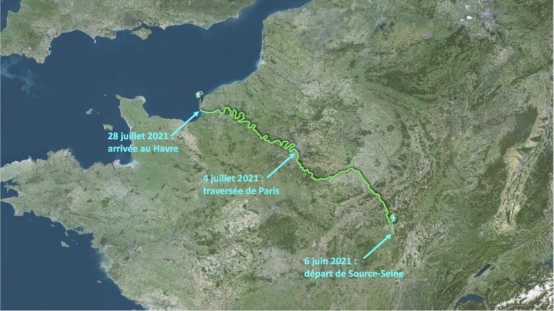
No one else has ever swum the entire length of the Seine. As an added wrinkle, he will pull a kayak behind him with gear and supplies, so that he can camp en route at least part of the time.
Germain wants to draw attention to pollution in the Seine. He himself was vaccinated against leptospirosis, a bacteria found in the river's water, before leaving.

In the wake of the May 22 tragedy in Gansu Province, in which 21 runners died of hypothermia when a storm hit, the Chinese government has banned all long-distance and off-road races.
These include races through deserts and mountains, and even wingsuit flying and other extreme sports that China considers "insufficiently regulated."
During the ban, the government will reassess safety measures and standards for such newly population competitions.

Since the tragedy, the race organizers have endured strong public criticism for their neglect and lack of transparency. They have begun to offer settlements to the families of the deceased, but the families, preferring answers, have refused.
Jonas Deichmann started his round-the-world triathlon in September 2020. He swam 456km in 54 days along the coast of Croatia, although he admits that he isn't a great swimmer. “[The swim] had its good moments, but I don’t want to do it again," he said.
Then he hopped on his bike -- he's better at that. Last week, the German athlete finished his 10,000km cycle across Russia to Vladivostok.
Overall, his self-imposed triathlon covers 40,000km. He is trying to do it with a minimal carbon footprint. Over the distance of 120 Ironmans, he will not use a support vehicle. He will hitchhike his way across any oceans on sailboats.
As usual over the 16 months for many of us, COVID restrictions threw a wrench into his travel plans. He wanted to cycle across the Balkans, through Turkey, then Russia, and China. From here, he was going to sail across the Pacific to San Francisco and begin running 5,040km across the U.S. to New York.
He duly cycled through the Balkans and a substantial way across Turkey. But when he arrived in Istanbul in mid-December, he discovered that the coronavirus had closed the border between Istanbul and Russia.

While he worked the bureaucracy to get into Russia somehow or other, Deichmann continued to train in southern Turkey. He waited 13 weeks. In the end, the German Triathlon Union, the German-Russian Forum, and the Russian Olympic Committee managed to obtain a Russian visa for him. This meant he could enter Russia through Bulgaria, Romania, Moldova, or Ukraine.
"Good luck, crazy boy!"
“Now the route to the Pacific is free of any bureaucracy and I can concentrate on riding my bike,” Deichmann said when he began pedaling to Vladivostok, the new endpoint of his cycling leg. As he cleared the Russian border, customs officials zestily sent him off with the words, “Good luck, crazy boy!”
Because of the time limit on his visa, he had to make it all the way across Russia in 60 days.
In the first week of cycling in Russia (and week 26 of the challenge), “the Russian winter makes life as a cyclist a fierce experience,” he noted. It only got harder as he crossed the Urals into Siberia. He had hoped to tackle Siberia in winter over frozen roads, but the delay forced him to travel in early spring.
It was warmer but at times impossibly muddy. Because of heavy traffic on the main roads, he had to switch to smaller unpaved byways, “which became a mud desert”. The mud got into the machinery of his bike, which made disconcerting grinding sounds as he pedaled. In every city, he took his bike to a car wash. But the next day, it was filthy again.

Still, he averaged about 190km a day. “Mentally, this stretch is almost more difficult than swimming," he said. "I ride eight hours a day and absolutely nothing happens.”
In the first few weeks, his main difficulty was the wind. At first, a tailwind nudged him along at 30km an hour. But after two days in Siberia, he faced headwinds, and his average speed plunged to 18km an hour. Once he battled through not only wind but a snowstorm and extreme cold. “Cycling across Russia in winter has been an amazing way to have an absolutely miserable time,” he said.
Food poisoning
The weather was not his only challenge. A week into Siberia, he caught food poisoning at a truck stop. “I had a delicious dish with chicken and soon realized that this was a mistake,” he said. The next morning, he felt like he was going to collapse so he spent a day recovering.
He reached Vladivostok on May 18. He is now trying to source a ride across the Pacific. From there, the next stage of his route is unclear. He was going to run across America but U.S. borders remain closed. He is now considering running 5,000km across Mexico from Tijuana to Cancun.
He sheltered the hypothermic competitors in a cave and gave them food and clothing.
As the events of the ultra-marathon tragedy of May 23 continue to unravel, a humble hero has emerged from the chaos. Zhu Keming, a shepherd, braved the freezing winds and rains to save the lives of several competitors.
Zhu Keming was having a pleasant Saturday morning tending his sheep when suddenly high winds and hail forced him into a nearby cave that he used in emergencies.
He kept food and dry clothes in there, but he didn’t think he'd need them that day. Not long after, his eyes spotted a distant competitor struggling with a cramp in his leg. He ran through the rain and helped the man to safety. Soon, more runners found refuge in the cave.
But the most remarkable rescue was that of competitor Zhangye Xiaotao. He had fallen unconscious after sending an SOS via his GPS tracker. Xiaotao was reportedly on the mountain for two-and-a-half hours before Zhu found him. The shepherd had ventured out to help other runners and came upon Xiaotao. He quickly brought him to the cave to warm him up. Zhu lit a fire and gave the three men and three women he saved whatever warm clothes, food, and blankets he had.

Public rage about the loss of life continues in China. The event organizers in nearby Baiyin city had ignored the adverse weather warnings for the 100km cross-country race. Some believe that this was due to their desire to improve tourism in the depressed mining towns by turning them into prime spots for extreme sports.
The race stopped at two pm after competitors sent out pleas for help via social media. However, many competitors did not receive the notice. Had Zhu not been there, there would have been more than 21 casualties.
As a result of the tragedy, five other races have been canceled.